• 検索結果がありません。

shallow Water ’06

N/A
N/A
Protected

Academic year: 2021

シェア "shallow Water ’06"

Copied!
12
0
0

読み込み中.... (全文を見る)

全文

(1)

B r e a k i N g WaV e s

shallow Water ’06

a Joint acoustic Propagation/

Nonlinear internal Wave Physics experiment

s i N c e t h e e N d of the Cold War, the US Navy has had an increasing inter- est in continental shelves and slopes as operational areas. To work in such areas requires a good understanding of ocean acoustics, coastal physical oceanography, and, in the modern era, autonomous underwater vehicle (AUV) operations.

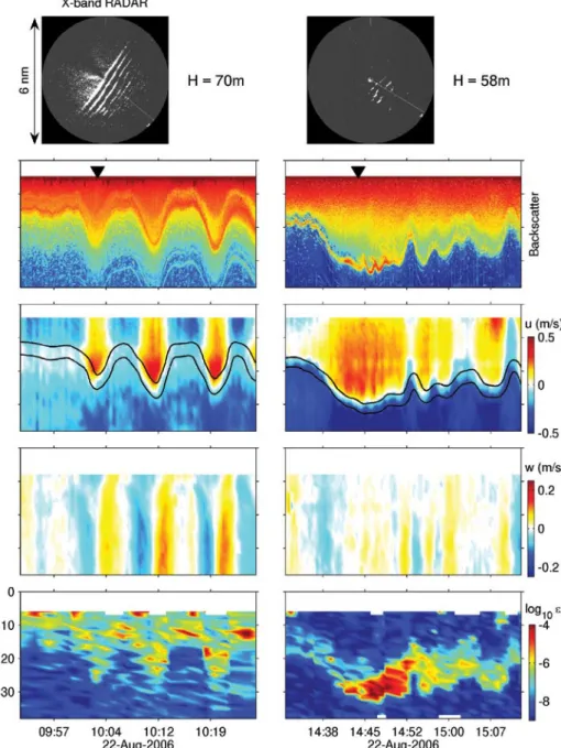
Each area presents challenges for both the scientist and the Navy. In physi- cal oceanography, a complex interplay among winds, rivers, tides, and local bathymetry drives a nonstationary, shelf- break front and the nonlinear inter- nal wave (NLIW) field. These strongly affect acoustic systems but are not adequately understood. A key oceano- graphic challenge is to model the fully four-dimensional ocean from the large- scale circulation down to fine scales, which include NLIW packets, internal tides, jets, and density fronts. Both Navy

acoustics systems and Navy opera- tions need the “local ocean weather” as well as the “ocean climate” as part of the routine forecast, but the former is not yet available.

In ocean acoustics, the Navy wishes to operate both at low frequencies (100–1000 Hz) and mid frequencies (1000–10,000 Hz), which poses ques- tions on a variety of spatial and temporal scales. For low-frequency acoustics, it has become obvious that fully three-dimen- sional (spatial) oceanography is neces- sary for propagation prediction. A bit more surprisingly, it appears that fully three-dimensional (spatial) acoustics codes might be necessary as well, a big divergence from the two-dimensional slice between source and receiver that has been adequate for ocean acoustics to date. At medium frequency, the effects of NLIWs on sonar systems are predicted

to be large and critical, but precious little experimental data combining acoustics with a well-characterized coastal ocean is to be found. Another challenge is to try to extrapolate the routinely measured

“single bounce” acoustic paths (those with one surface or bottom interaction) to predict how multiple-bounce sonar systems would perform.

In using autonomous vehicles, rapidly and efficiently sampling the oceanogra- phy, particularly the temperature field, so as to optimize the placement and performance of acoustics systems is a major technical hurdle to be cleared. The Navy is increasingly interested in using AUVs and gliders for such work, as they can operate persistently over large areas, comparatively inexpensively.

To pursue these questions, the Office of Naval Research (ONR) spon- sored a large, multidisciplinary, multi- B y d a J u N ta N g , J a m e s N . m o u m , J a m e s F. Ly N c h , P h i L a B B o t, r o s s c h a P m a N , P e t e r h . d a h L , t i m o t h y F. d u d a , g L e N g aWa r k i e W i c z , s c o t t g L e N N , J o h N a . g o F F,

h a N s g r a B e r , J o h N k e m P, a N d r e W m a F F e i , J o N at h a N d . N a s h , a N d a r t h u r N e W h a L L

This article has been published in Oceanography, Volume 20, Number 4, a quarterly journal of The oceanography society. copyright 2007 by The oceanography society. all rights reserved. Permission is granted to copy this article for use in teaching and research. republication, systemmatic rep or collective redistirbution of any portion of this article by photocopy machine, reposting, or other means is permitted only with the approval of The oceanography society. send all correspondence to: [email protected] or Th e oceanography society, Po Box 1931, rockville, md 20849-1931, usa

(2)

institution, multinational experiment off the coast of New Jersey in summer 2006, designated “Shallow Water ’06” (SW06).

This large-scale experiment had three named components corresponding to the three major research and technology thrusts: in acoustics, LEAR (for Littoral Environmental Acoustics Research); in physical oceanography, NLIWI (the Non Linear Internal Waves Initiative); and in vehicles, AWACS (for Acoustic Wide Area Coverage for Surveillance).

eXPerimeNtaL setuP aNd Logistics

Over its two-month duration (mid- July to mid-September), the SW06 experiment entrained enormous resources: seven ships, 62 moorings, aircraft overflights and satellite cover- age, a fleet of ten oceanographic gliders, data-assimilating numerical modeling,

real-time data communication from a number of shipboard experiments, and dozens of principal investigators tending to their parts of this coordinated effort.

Two of the logistical components of this effort merit special attention due to their sheer size and novelty: (1) moor- ing layout, construction, deployment, and recovery, and (2) real-time data and experiment-status communications via the SW06 Web site.

moorings

The core measurement suite of the SW06 experiment was an array of 62 acoustics and physical oceanography moorings (57 long term, 5 short term) that were deployed in a “T” geometry, with the stem of the T stretching 30 km along- shelf at the 80-m isobath, and the top of the T stretching 50 km across-shelf from the 500-m isobath to the 60-m isobath

(see Figure 1). The geometry and place- ment of the T were arranged to provide good along- and across-shelf views of the shelf-break front, the local eddy field, and the nonlinear internal wave field, three oceanographic quantities of primary interest. A small (10 x 10 km

2

) moored oceanography array was placed at the crossing of the T to look at fully three-dimensional (spatially) nonlinear internal wave structure.

The T geometry was very efficient for notifying fishermen and other mariners where our equipment was located—we simply had to specify the endpoints and crossing of the T. As a result, no gear was lost to fishing activity. Amazingly, we recovered every mooring that we deployed, with about 95% data return, despite having one lithium battery pack explode and one mooring drift out to sea after Hurricane Ernesto.

Figure 1. a graphic overview of the

sW06 experiment. moored instru-

mentation is deployed in lines in the

along-shelf and across-shelf directions

to observe shelf-break front and internal wave pack-

ets. a fully three-dimensional array at the intersec-

tion of the “t” is designed to study the wave-front

length scales of nonlinear internal waves. a fleet of

six gliders monitors mesoscale oceanography in the

region. an “L”-shaped array of hydrophones consists

of a horizontal and a vertical line array, and monitors

sound transmissions throughout the experiment,

while moored and shipboard sources transmit sig-

nals. ships carry out oceanographic, geologic, and

acoustic research while networked to each other and

to laboratories ashore to share information. Planes

and satellites overhead image internal waves and

other ocean processes. The bathymetry in the figure

is an artist’s rendition showing generally correct but

not exact features.

(3)

Web site

New challenges in the area of oceano- graphic experiment logistics, real-time field communication, and data fusion and exchange led to the creation of Web- based software tools to enable coordi- nated, real-time collaboration between researchers at sea and ashore. SW06 researchers could monitor the location of several ships, dozens of moorings,

assorted underwater vehicles, and other platforms in near real time. Information gathered off the Internet was merged with information collected during oper- ations at sea and inserted into a basic framework to provide additional sup- port. A primarily wireless network com- prised of satellite, shipboard, and global Internet links was used to synchronize Web sites on five ships and multiple shore-based servers so that all partici- pants in the experiment could contrib- ute and monitor platform locations/

deployment; ship, glider and aircraft tracks; daily reports; weather informa- tion; CODAR (Coastal Ocean Dynamics Applications Radar) and satellite imag- ery; and ocean-model results. These Web tools allowed us to collect and organize this information into a usable form, and also provided a searchable, time- based archive of the entire experiment.

The development of these tools was an

important contribution to the experi- ment, providing the means for using research vessels on scientific expeditions as parts of a real-time ocean observatory.

PhysicaL oceaNogr aPhy (NLiWi)

One of the principal foci of the experi- ment was internal waves. These come in two general types: (1) linear internal waves that include long-wavelength (tens of kilometers) entities such as internal tides and near-inertial waves, and follow

a linear wave equation, and (2) nonlin- ear internal waves that have short length scales (hundreds of meters), are charac- terized by large particle velocities, and follow nonlinear wave equations such as the Korteweg-deVries equation. These nonlinear waves have a large acoustical effect, and we now know that they can be found all over the world’s ocean shelves.

Indeed, they are nearly as common as surface waves, given stratified waters.

Internal-wave activity on the New Jersey slope is particularly well docu- mented through both satellite synthetic aperture radar (SAR) imagery (Jackson and Apel, 2004) and previous in situ experiments (Apel et al., 2006). SAR imagery clearly reveals the surface sig- natures of wave packets (Figure 2) that appear to originate near the shelf break and propagate shoreward. But this pic- ture is not a totally simple one. Irregular bathymetry near the shelf break, such as canyons, can produce circular wave fronts that combine with the planar ones from the shelf break and with each other.

Along the New Jersey coast, the ambi- ent stratification is also complicated by the existence of a shelf-break front (a salinity-density front/current com- bination that meanders near the shelf edge), the frequent presence of warm-

daJuN taNg is Senior Engineer, Applied Physics Laboratory, University of Washington, Seattle, WA, USA. James N. moum is Professor, Oregon State University, Corvallis, OR, USA. James F. LyNch ([email protected]) is Senior Scientist, Woods Hole Oceanographic Institution, Woods Hole, MA, USA. PhiL aBBot is President, OASIS, Inc., Lexington, MA, USA. ross chaPmaN is Professor, University of Victoria, Victoria, British Columbia, Canada. Peter h. dahL is Principal Engineer, Applied Physics Laboratory, University of Washington, Seattle, WA, USA. timothy F. duda is Associate Scientist, Woods Hole Oceanographic Institution, Woods Hole, MA, USA. gLeN gaWarkieWicz is Senior Scientist, Woods Hole Oceanographic Institution, Woods Hole, MA, USA. scott gLeNN is Professor, Rutgers University, New Brunswick, NJ, USA. JohN a. goFF is Senior Research Scientist, University of Texas at Austin, Austin, TX, USA. haNs graBer is Professor, University of Miami, Miami, FL, USA. JohN kemP is Senior Engineering Assistant II, Woods Hole Oceanographic Institution, Woods Hole, MA, USA. aNdreW maFFei is Senior Information Systems Specialist, Woods Hole Oceanographic Institution, Woods Hole, MA, USA. JoNathaN d. Nash is Associate Professor, Oregon State University, Corvallis, OR, USA. arthur NeWhaLL is Information Systems Specialist, Woods Hole Oceanographic Institution, Woods Hole, MA, USA.

sW06 researchers could monitor the

location of several ships, dozens of moorings, assorted underwater vehicles,

and other platforms in near real time.

(4)

core eddies shed from the Gulf Stream, strong freshwater influences, near-iner- tial wave activity, and the frequent pas- sage of tropical storms. The complex- ity that all this variability induces into the internal wave field is important to acoustics. As a matter of physical ocean- ography/acoustics synergy, the suite of moored instruments was designed not only to focus on fundamental aspects of internal-wave physics but also to sup- port the acoustics measurements by

defining both the space/time variability of the sound-speed field and the propa- gation of individual nonlinear internal wave trains through the acoustics array.

Numerous local shipboard measure- ments were made to investigate the evolving wave structure and energetics and to support short-range acoustics experiments. A considerable modeling effort combining oceanography, acous- tics, and Navy needs augments these observations. These models encompass

mesoscales to NLIW scales, represent- ing an ambitious drive to cover yet more of the full-ocean spectrum with data- assimilating models.

From an observational perspec- tive, the primary objectives were (1) to understand and describe the two- and three-dimensional structures of NLIWs in sufficient detail to aid in improving wave models beyond small-amplitude wave theories that are inadequate but still in use, (2) to define the energy evo- lution and transport, and (3) to identify wave-generation sites, times, and mecha- nisms. These are all necessary for predic- tion of wave generation and propagation over the continental shelf. In addition, important efforts include a quantita- tive physical assessment of surface radar signatures in terms of small-scale sea- surface variability.

Background oceanographic conditions and Nonlinear internal Waves in sW06

While NLIWs appear like clockwork in some parts of the world’s ocean (like the South China Sea; Ramp et al., 2004), prediction of the nonlinear internal wave climate over continental shelves is noto- riously difficult. During SW06, NLIW packets were observed at all phases of the barotropic tide. This variability in the timing of waves is not unlike previous continental shelf observations (Colosi et al., 2001; Moum et al., 2007). More importantly, and entirely counter to our expectations, larger and more frequent waves appeared during neap tides than during spring tides (which peaked on 11 August). One of the more interesting challenges posed by our data will be to reconcile this curious observation with our initial expectations.

Figure 2. radarsat observation from august 13, 2006. Part of the across-shelf

mooring array is shown in the figure to provide scale. The structure of the

nonlinear internal wave packets, including some pronounced curvature of

the wave fronts, is clearly visible. understanding the correlation of these sur-

face images with subsurface observations is one of the objectives of sW06.

(5)

Figure 3. detailed acoustic backscatter, velocity (components shown are in the direction of wave propagation, u, and vertical, w), and turbulence (ε) observations of a nonlinear internal wave packet tracked by r/V Oceanus while propagating onshore over the New Jersey shelf during sW06. two isopycnals are plotted over the u image. The two columns show two stages of wave- packet evolution. during the 5-h separation between these observations, the wave propagated 17 km (wave speed ≅ 0.8 m s

-1

), or almost 100 wavelengths. The wave-packet evolution is sig- nificant; it changes from a well-defined set of radar wave fronts and an internal velocity/density structure that is clearly representative of solitary-like waves to a less-ordered structure marked by extreme turbulence at the base of its velocity core. This in turn is associated with what appear to be small-scale kelvin-helmholtz billows (as seen in the acoustic backscatter). These observa- tions were made using shipboard acoustics and the chameleon turbulence profiler. Figure cour- tesy Emily Shroyer, Oregon State University

observations

Intensive moored observations were designed to capture both mesoscale oceanography and the high-frequency wave climate. Water-column velocity, temperature, and salinity were measured with ~10-m resolution from ten dedi- cated oceanography moorings. Five bot- tom landers were deployed at 70-, 80-, 85-, 110-, and 125-m water depths to measure near-bottom density, pressure, and turbulence as well as full-water-col- umn velocity structure at 5-s intervals.

Two Air-Sea Interaction Spar (ASIS) buoys were deployed at 70- and 80-m water depths to measure atmospheric conditions, to quantify the surface grav- ity wave field, and to measure near- surface currents and density. Most instruments were sampled at 30-s inter- vals to resolve high-frequency waves.

Multiple ships were used to chase wave packets across the continental shelf, hopefully from their birth sites to their death sites. Shipboard experiments to track evolving wave groups, including slaloming through the three-dimensional moored array cluster, were conducted from R/Vs Endeavor and Oceanus. These observations included acoustic Doppler current profilers sampled at high spa- tial and temporal resolution (to map the NLIW velocity field in detail) and in situ measurements of temperature, salinity, and small-scale turbulence.

Highly detailed depictions of wave

groups obtained (Figure 3) from these

data show the evolving structures of

individual waves and how their relative

positions within wave groups change as

they propagate onshore. Shipboard wave

tracking also provided clear observations

of so-called “varicose” (mode-2) waves

in a geophysical fluid (that is, waves that

(6)

both elevate isopycnals above a density interface and depress them below) and the change in sign from depression waves to elevation waves as they shoal.

Shipboard observations also included X-band radar measurements of the sea surface (Figure 3). These records pro- vided depictions of the wave fronts over 3-nm ranges from the ships, extend- ing our understanding of the shapes of the wave fronts beyond their points of intersection with the ships. Wave-front shapes were tracked even further by aircraft radar flights and satellite SAR observations. One of the challenges of NLIWI will be to obtain a first-order understanding of the structure of the evolving wave fronts.

To monitor the critical mesoscale vari- ability, a suite of 10 gliders was deployed with the goal of continually flying six of these through the moored array, a goal that was largely achieved. These observa- tions were augmented by Scanfish sur- veys extending across the shelf and over the continental slope to provide a broad perspective of the variability of the shelf-

break front and other mesocale varia- tions in currents, temperature, and salin- ity. Author Abbot and co-investigators are preparing a WHOI technical report on these surveys.

Two new types of observations were exploited to investigate the NLIWs.

One of these was deployed from a ship and used a broadband (120–600 kHz)

swept acoustics system of four transduc- ers to remotely detect the spectrum of backscattering generated by small-scale sound speed microstructure created by turbulence instabilities within waves.

This measurement augments profiling observations of turbulence by providing a continuous sequence between profiles.

It also helps to identify the detailed phys- ical structure of the waves.

High-resolution pressure sensors were deployed on three bottom landers along the array. Results show that the seafloor pressure signal of the NLIWs observed by other means during SW06 is measurable (Moum and Nash, in press). This rela- tively simple measurement suggests new ways to design NLIW detection antennae.

modeling

Modeling of currents and stratifica- tion (including sound speed) from the synoptic to the wave scale is ongoing.

At large scales, the Regional Ocean Modeling System assimilated data from all platforms to provide real-time maps of the relevant fields. At intermediate

scales, the nonhydrostatic MIT general circulation model was nested within the larger model to provide clues as to how the observed NLIWs are generated. At the scale of the waves, a novel model based on optimized mesh-point place- ment provides detailed simulations of small-scale tide-topography interaction and wave generation. The challenge to

the modelers is to represent the sound- speed field from the mesoscale to the small-scale fluctuations caused by the nonlinear waves.

geoLogy (Lear)

The seabed forms the bottom bound- ary condition for shallow-water acoustic and oceanographic experiments, such as SW06. While understanding the acoustic properties of the seabed is of obvious importance to the acoustic experiments, and the bathymetry and roughness is important to the oceanography, we also seek a geologic understanding of the sediments and the stratigraphic geom- etries in which they were deposited. This type of information provides context for understanding the results and for applying what we learned to other areas.

The stratigraphic geometries can help guide extrapolation of bottom inverse results from one location to other parts of the survey region.

One of the big attractions of the SW06 area was the fact that, in addition to having interesting physical oceanogra- phy, the seabed had been examined and characterized by previous experiments, thus saving a large amount of effort and money. Any further geological work and stratigraphic surveying would be answering more detailed questions about the bottom, in accord with SW06’s status as a “higher-order effects” type of experi- ment, not an initial survey.

Much of the previous geological work in this area was sponsored by ONR, in large part as a response to a system of buried, remnant river channels just below the seafloor that were suspected to be the sources of “geo-clutter”(false tar- get backscatter returns due to geology) in Navy sonar systems. Such buried chan-

the seabed forms the bottom boundary

condition for shallow-water acoustic and

oceanographic experiments, such as sW06.

(7)

Figure 4. schematic representation of stratigraphic elements along the strike-and-dip lines (Figure 5) of the sW06 experiment. The strike of a stratum is a line representing the intersection of that feature with the horizontal; the dip is the angle below the horizontal of a tilted stratum.

The star represents the approximate location of the “cross-hairs” of the sW06 experiment.

nels are quite common on continental shelves, and so the New Jersey shelf pro- vided a natural laboratory for looking at this effect. The interested reader can find the history of this fascinating work in the following references: initial map- ping of fluvial channels (Davies et al., 1992); multibeam surveys and bathym- etry (Goff et al., 1999); geophysical and geological sample data (e.g., Goff et al., 2004; Nordfjord et al., 2005, 2006); and long-coring efforts (Nordfjord et al., 2006). As a postscript, it was found that the “geo-clutter,” though appreciable, was often swamped by “bio-clutter” (i.e., reverberation returns from schools of fish on the shelf and often near the shelf break [Makris et al., 2006]). A large ONR experiment to study this type of clutter was initiated as a result.

Though our understanding of the

overall geologic history of the SW06 region has grown immeasurably (e.g., Duncan et al., 2000; Goff et al., 2005; Gulick et al., 2005; Nordfjord et al., 2006), major gaps still remain.

The “R” horizon is the most prominent and widespread feature in the shallow subsurface (e.g., Milliman et al., 1990;

Gulick et al., 2005; Figure 4). We know from sampling and age dating that it is approximately 40,000 years old, but the reasons for its existence are still the sub- ject of much speculation. The new SW06 chirp data and future long coring should provide critical new morphologic and stratigraphic constraints on the origin of R. Lying on top of R is the outer-shelf wedge, composed of alternating layers of sand and mud that are imaged as numer- ous layered reflections in chirp seismic data. These sediments were most likely

deposited as sea level was falling in the lead-up to the last glacial maximum. In some locations, most notably the cen- tral site of the SW06 experiment, the top of the layered outer shelf wedge is very erose, cut by grooves oriented ~ east- west, and then filled with sediments that are acoustically transparent (Fulthorpe and Austin, 2004). This surface may be evidence of some sort of catastrophic flood event, or perhaps the grooves were created by icebergs grounding along an ancient seabed. New core samples should help us to resolve the origin of this boundary.

At some time during the last glacial maximum, while sea level was much lower and almost the entire continental shelf was exposed, dendritic networks of river channels were carved into the mid-shelf wedge (the “C” horizon in Figure 4) and, where the wedge thinned, through R as well. When sea level subse- quently rose following the melting of the ice-age glaciers, the channels were filled by a sequence of estuarine sediments: a fluvial lag of sand and gravel at the base, followed by muddy sediments deposited where the river met the tide, followed by beach barrier sands (Nordfjord et al., 2006). These sediments, ~ 12,000 years old in the SW06 region, form recogniz- able layers in the chirp seismic record of the channel-fill sediments. Continued sea-level rise caused the shoreline to pass over the buried channels, creating a wide- spread erosion surface referred to as the

“T” horizon. Large sand bodies formed

in the nearshore environment on top of

T, and these were shaped into large bed-

forms (~ 1–5 m high, 1–4 km wide, and

2–10 km long) called sand ridges. These

features are so large that they persist to

the present day and can be easily mapped

(8)

in the multibeam bathymetry data. But the seabed does not become quiescent with increasing water depth. Evidence in the multibeam and chirp data sug- gests widespread regions of recent and modern erosion, which has removed the sand sheet in many places, exposing both the T and the R horizons at the seafloor.

The result is a seabed with highly vari- able sedimentary and physical properties, which will be of great importance to the SW06 acoustics experiment results.

acoustics (Lear)

Though acoustics was the largest over- all component of SW06, it makes sense to discuss it after the oceanography and geology, as these set the context for acoustic propagation and scatter- ing. The SW06 experiment had both low-frequency (100–1000-Hz) and medium-frequency (1000–10,000-Hz) components, and examined issues in forward propagation, scattering, and inverse theory.

Low-Frequency Propagation In doing the acoustics transmissions, we used both moored and shipboard sources and receivers. The primary moored receiver site for propagation studies was at the along/across-shelf intersection of the T-shaped mooring, as that is where we have the best oceano- graphic information. At that site, a long- term horizontal/vertical line array with 48 hydrophone channels was deployed, sampling sound from 50–4500 Hz con- tinuously over a six-week period. This array was augmented by other receiv- ers, (mostly) near the same site, as well as five long-term “single hydrophone receiver units” distributed along the across-shelf line. The moored sources were arranged on the along- and across- shelf lines as well, as these are where we had the best environmental support, and, also, these were “limiting cases” for the azimuthal variations of the acous- tic path. These moored sources were augmented by some shipboard sources,

which allowed us to fill in the azimuthal propagation direction spectrum.

There are a number of open questions about low-frequency, shallow-water propagation. One of the most interesting of these concerns the azimuthal depen- dence of shallow-water sound propaga- tion, specifically its strong dependence upon the angle between the acoustic path and the propagation direction of the nonlinear internal wave field (when present). Sound can travel readily in the acoustic duct that is created between individual soliton packet waves, in a manner that keeps the acoustic modes separate and distinct. This leads to higher-intensity regions of the acoustic field, as seen in the top panel of Figure 5.

On the other hand, sound that travels perpendicular to the propagation direc- tion of the nonlinear internal waves suf- fers intense coupling between the modes, which can lead to the severe attenuation of sound (depending upon where one places the source relative to the sur-

Figure 5. The top panel shows, in a top view, a computer model of ducting of sound between nonlinear internal wave crests (denoted by white dashed lines), a known and experimen- tally observed phenomenon.

The bottom panel shows a

top view of the ducting and

horizontal dispersion of sound

between two curved nonlinear

internal wave crests, an effect

that should be observable and

provable using the sW06 data

set. color gradation denotes

(relative) intensity in dB.

(9)

face mixed layer and thermocline.) At angles intermediate to these extremes, a combination of these effects occurs, and we presently have a rather limited ability to predict the acoustic field for this case due to both oceanographic and acoustic complexity.

Another interesting question about acoustic propagation in shallow water is how much energy is reflected out of plane by internal waves and coastal fronts when the acoustic path is at low (grazing-angle) incidence to these ocean features. The interference of a straight acoustic track (that does not interact with these ocean features) and a reflected path can cause very large, fully three- dimensional acoustic fluctuations, as have been seen in numerous computer simulations. Verification (or refutation) of such effects is an interesting experi- mental question, and data from SW06 should shed light on this. Yet another question of great interest to LF acoustics is how the three-dimensional irregularity of fronts and the curvature of nonlinear internal waves (which are often taken as two-dimensional, along-shelf symmet- ric entities to first order) affect acoustic propagation. There is an example of curvature effects in the bottom panel of Figure 5. These curvature effects can lead to both horizontal ducting and horizon- tal dispersion of sound rays (or “light pipe” and “rainbow” effects in optical parlance), and, in terms of Navy systems, false target bearings, a major concern.

medium-Frequency Propagation Many practical sonar systems operate in the mid-frequency band between 1 and 10 kHz. In shallow-water regions, the performance of such systems is strongly influenced by the bottom, sea surface,

and water column. This influence can be in the form of sound scattering, refrac- tion, and attenuation. Uncertainties in any or all of these categories are com- mon, so knowing the various mecha- nisms governing acoustic interaction with the environment is essential to improving sonar performance in shallow water. To gain quantitative understand- ing of how sound interacts with these environmental factors, it is essential to measure all relevant environmental parameters at sufficient spatial and tem- poral resolutions, which can be quite fine for mid-frequency acoustics.

The mid-frequency efforts of SW06/

LEAR were concentrated on receiving arrays moored in the central area, where the water depth is about 80 m. Five major measurements were made there:

(1) short-range acoustics interaction with the bottom and surface, (2) in situ measurement of sediment sound speed to a depth of 1.7 m, (3) bottom backscat- ter, (4) short-range propagation through known internal waves, and (5) long- range propagation to 10 km along the

same track with multiple source depths, frequency bands, and different times.

To study bottom and surface reflec- tion coefficients and their anisotropy, short-range bottom/surface interaction measurements were first made at ranges from 50 m to 1000 m from multiple directions with respect to the moored

MORAY1 receiving array from a source deployed from R/V Knorr, within the frequency range 1–20 kHz. A second measurement transmitted both mid- and low-frequency sound (0.05–4 kHz) at a range of 200 m around a circular path encompassing the MORAY1 location.

A new sediment acoustics measure- ment system (SAMS) was developed to measure in situ sediment sound speed to a depth of 1.7 m with 0.1 m depth incre- ments. This is accomplished by using a vibro-core fitted with a hydrophone at its tip to penetrate into the bottom in controlled depth-steps while 10 acoustic sources located above the bottom trans- mit sound in the band of 2–35 kHz. This source-and-receive arrangement provides many ray paths crisscrossing the sedi- ment volume, so sediment sound speed as a function of depth is directly imaged.

Bottom backscatter in the frequency band of 3–10 kHz was measured by both a parametric source and by an omnidirectional source combined with a 32-element, vertical-line hydrophone array. Supporting this effort, sediment

roughnesses were measured using a sediment conductivity probe that can measure one-dimensional roughness to a resolution of 10 mm in the hori- zontal direction and 1 mm in the verti- cal. In addition, a laser scanner was also deployed to provide two-dimensional roughness measurements to a resolu-

a major objective in sW06 was to estimate

the regional geoacoustic environment using

the best present-day inversion techniques.

(10)

tion of 1 mm in both the horizontal and vertical directions.

The effect of nonlinear internal wave trains on mid-frequency sound propa- gation was measured with the goal of making deterministic assessment of the impact by taking “snap shots” of the internal waves along the acoustic path.

This was accomplished by a transmission from a source deployed from R/V Knorr to the MORAY1 receiving array stationed 1000 m away. A CTD chain with 50 ele- ments was towed at 6 kt in the vicinity of the source and receiver by a second ship, R/V Endeavor. Both acoustics and CTD- chain measurements were made in the presence and absence of internal waves, so the impact of internal waves on mid- frequency sound propagation can be quantitatively evaluated

Finally, mid-frequency, long-range propagation to a 10-km range along the same track on different days with dif- ferent bandwidths was studied. This research focused on the temporal vari- ability of propagation loss, and also bottom parameter inversion and mode stripping due to surface scattering.

Low- and medium-Frequency Bottom inverses

Underwater acousticians often use “geo- acoustic models” (local sediment layers described by their density, compressional and shear wave speeds, and attenua- tions) to characterize the bottom for making predictions of the sound levels in the sea. A major objective in SW06 was to estimate the regional geoacoustic environment using the best present-day inversion techniques. Several groups collaborated in experiments that used sound sources over a broad band of frequencies to characterize the bot-

tom, especially at sites where there was extensive geological “ground truth” of the ocean bottom. The technical chal- lenge here is to perfect acoustic survey techniques for bottom properties, which, despite much work over decades, are still being refined and improved. Of equally strong interest to marine sedi-

ment acousticians is the opportunity to measure the sediment sound speed dis- persion (real and imaginary parts) over a broad frequency band.

The most intensively studied site was the central area at 80-m water depth.

As mentioned, this site was first instru- mented with a mid-frequency hydro- phone array to measure acoustic reflec- tivity from the seabed at frequencies from 1–20 kHz. On a second visit to the site, we studied sound reflectivity and acoustic propagation at lower frequencies, from 4 kHz down to 50 Hz. The combined set of mid- and low–frequency data and accompanying measurements on geo- acoustic properties will provide a unique opportunity to both compare techniques and study dispersion properties.

Another of the current research chal- lenges in doing bottom geoacoustic property inversions, particularly at low frequencies where there are large path lengths between source and receiver, is to eliminate water column fluctuation effects from the inverse for the bottom.

Use of inverse methods often requires

dealing with a large component of water- column fluctuation noise in the data.

However, it is completely unrealistic to ask inverse methods to present an exact realization of the ocean between the source and receiver. Recently developed methods minimize the effects of water- column fluctuations on such inverses,

based on knowing only the simple statis- tics of water-column fluctuations. As the SW06 experiment provides both high- quality measurements of ocean fluctua- tions and independent data on ocean- bottom structure and properties, this method can be tested with some rigor.

Many teams investigated the bot- tom-inversion issue using different tech- niques over a wide range of frequencies in this experiment. The combination of all the inversion results offers an oppor- tunity, through a synthesis process, to obtain a consistent bottom model of the area that can be used to evaluate future sonar models.

aWacs

Two of the most active and promising technologies in oceanography are pow- ered AUVs and AUV gliders. As part of SW06, a component of the AWACS (Acoustic Wide Aperture Coverage for Surveillance) project was conducted to utilize both powered and glider AUVs.

The objectives were to: (1) conduct oceanographic surveys of an “interest-

two of the most active and promising

technologies in oceanography are

powered auVs and auV gliders.

(11)

ing area” of ocean (e.g., near the shelf- break front, or in a packet of solitons), (2) create an oceanographic map of that area based on the data, (3) pick a geom- etry most favorable for acoustic propa- gation/detection based on that oceano- graphic map, and (4) use moored and sonobuoy-based acoustic sources and receivers to demonstrate that the geome- try so chosen was indeed an optimal one.

In pursuing this plan, small-boat operations were needed for deploying and recovering the small REMUS 100 AUVs and Webb gliders that were to be utilized. Unfortunately, the fringes of hurricanes Ernesto and Florence prohib- ited small-boat operations. (But fortu- nately for future programs, this incon- venient small-boat technique has since been superseded by fully “off the deck”

operations!). Thus, we used Scanfish sur-

veys from the ship for oceanography and Oasis mobile acoustic sources and sono- buoy receivers for the acoustics. With this hurricane-induced “Plan B,” we were still able to perform the “adaptive acoustic sampling” part of the project. This suc- ceeded well, with especially interesting results coming from trying to predict the shelf-break front and its acoustic effects, as illustrated in Figures 6a and 6b. In these figures, we show the anisotropy in acoustic propagation loss versus azimuth for propagation in the region of the shelf-break front. The anisotropy effects due to fronts and internal waves were of particular interest in SW06.

PostscriPt

In the year that has passed since the SW06 experiment, great progress has been made in digesting the many tera-

bytes of data collected. We have made movies of acoustic arrivals at the arrays that graphically show their stability in oceanically calm periods and their gyra- tions during active periods. In addi- tion, motion pictures of the nonlinear internal waves recorded by our “three- dimensional” mooring array are just coming into being. This graphic imag- ery, and much more analysis (some not quite so flashy), are providing the grist for a number of scientific publi- cations. We have already lined up spe- cial sessions in a number of technical society meetings and a special issue in the Journal of the Acoustical Society of America. We hope that this “prelude”

in Oceanography will stimulate readers’

interest in the further publications that will be coming out shortly from this very successful experiment.

Figure 6. (a) The top panel shows tracks of oasis mobile acoustic sources (large red and blue circles) emitting sounds to sonobuoy receivers (darker red and

blue arc-segments within the circles) in the vicinity of the shelf-break front, in order to study the effects of frontal and shelf oceanography on sound propa-

gation. (b) The bottom panel displays average acoustic propagation loss at 900 hz and clearly shows: (1) near azimuthal isotropy over the shelf region, and

(2) anisotropy (more loss) where the acoustic paths cross the shelf-break front, in the angular sector from (roughly) 90 to 180 degrees. Prediction of the posi-

tion of the shelf-break front was one of the oceanographic challenges of aWacs.

(12)

Alexander. 2005. Recent and modern marine ero- sion on the New Jersey outer shelf. Marine Geology 216:275–296.

Goff, J.A., B. Kraft, L.A. Mayer, S.G. Schock, C. K.

Sommerfield, H.C. Olson, S.P.S. Gulick, and S.

Nordfjord. 2004. Seabed characterization on the New Jersey middle and outer shelf: Correlability and spatial variability of seafloor sediment proper- ties. Marine Geology 209:147–172.

Goff, J.A., D.J.P. Swift, C.S. Duncan, L.A. Mayer, and J.

Hughes-Clarke. 1999. High-resolution swath sonar investigation of sand ridge, dune and ribbon mor- phology in the offshore environment of the New Jersey margin. Marine Geology 161:307–337.

Gulick, S.P.S., J.A. Goff, J.A. Austin Jr., C.R. Alexander Jr., S. Nordfjord, and C.S. Fulthorpe. 2005. Basal inflection-controlled shelf-edge wedges off New Jersey track sea-level fall. Geology 33:429–432.

Jackson, C.R., and J.R. Apel. 2004. An atlas of internal solitary-like waves and their properties. Global Ocean Associates. 2

nd

ed. Available online at: http://

www.internalwaveatlas.com.

Makris, N.C., P. Ratilal, D.T. Symonds, S. Jagannathan, S. Lee, and R.W. Nero. 2006. Fish population and behavior revealed by instantaneous continental shelf-scale imaging. Science 311:660–663.

Milliman, J.D., Z. Jiezao, L. Anchun, and J.I. Ewing.

1990. Late Quaternary sedimentation on the outer and middle New Jersey continental shelf: Result of two local deglaciations? Journal of Geology 98:966–976.

Moum, J.N., J.M. Klymak, J.D. Nash, A. Perlin, and W.D. Smyth. 2007. Energy transport by nonlinear internal waves. Journal of Physical Oceanography.

Moum, J.N., and J.D. Nash. In press. Seafloor pressure measurements of nonlinear internal waves. Journal of Physical Oceanography 37:1,968–1,988.

Nordfjord, S., J.A. Goff, J.A. Austin Jr., and S.P.S.

Gulick. 2006. Seismic facies of incised valley-fills, New Jersey continental shelf: Implications for erosion and preservation processes acting during late Pleistocene/Holocene transgression. Journal of Sedimentary Research 76:1,284–1,303.

Nordfjord, S., J.A. Goff, J.A. Austin Jr., and C.K.

Sommerfield. 2005. Seismic geomorphology of buried channel systems on New Jersey shelf:

Assessing past environmental conditions. Marine Geology 214:339–364.

Ramp, S.R., T.Y. Tang, T.F. Duda, J.F. Lynch, A.K.

Liu, C-S. Chiu, F.L. Bahr, H.-R. Kim, and Y.-J.

Yang. 2004. Internal solitons in the northeastern South China Sea, Part I: Sources and deep water propagation. IEEE Journal of Ocean Engineering 28(4):1,157–1,181.

ackNoWLedgemeNts First, we would like to thank our ONR sponsors, particularly Drs. Ellen Livingston, Theresa Paluszkiewicz, and Tom Curtin for their support of the SW06 experiment, and their help in coordinating its efforts. Next, we would like to thank the many co-PIs whose names do not appear on this paper (only direct contributors appear), but whose efforts and research in SW06 are the topic of this paper. Third, we would like to thank the numerous technicians, engineers, programmers, office person- nel, students, and others whose efforts underpinned this large effort. Finally, the captains and crews of the research ships that participated in SW06 get our hearti- est praise and thanks. Overall, SW06 was executed by a very talented, hardwork- ing, and collegial group, and they made both the experience, and the results, fantastic. We all look forward to the next few years of continued work together on this vast, rich data set.

reFereNces

Apel, J.R., L.A. Ostrovsky, Y.A. Stepanyants, and J.F.

Lynch. 2006. Internal solitons in the ocean. WHOI Technical Report WHOI-2006-04.

Colosi, J.A., R.C. Beardsley, G. Gawarkiewicz, J.F.

Lynch, C.S. Chiu, and A. Scotti. 2001. Observations of nonlinear internal waves on the outer New England continental shelf during the summer shelfbreak PRIMER study. Journal of Geophysical Research 106(C5):9,587–9,601.

Davies, T.A., J.A. Austin Jr., M.B. Lagoe, and J.D.

Milliman. 1992. Late Quaternary sedimentation off New Jersey: New results using 3-D seismic profiles and cores. Marine Geology 108:323–343.

Duncan, C.S., J.A. Goff, and J.A. Austin Jr. 2000.

Tracking the last sea-level cycle: Seafloor mor- phology and shallow stratigraphy of the latest Quaternary New Jersey middle continental shelf.

Marine Geology 170:395–421.

Fulthorpe, C.S., and J.A. Austin Jr. 2004. Shallowly buried, enigmatic seismic stratigraphy on the New Jersey outer shelf: Evidence for latest Pleistocene catastrophic erosion? Geology 32:1,013–1,016.

Goff, J.A., J.A. Austin Jr., S. Gulick, S. Nordfjord, B.

Christensen, C. Sommerfield, H. Olson, and C.

Figure 1. a graphic overview of the  sW06 experiment. moored  instru-mentation is deployed in lines in the  along-shelf and across-shelf directions  to observe shelf-break front and internal wave  pack-ets
Figure 2. radarsat observation from august 13, 2006. Part of the across-shelf  mooring array is shown in the figure to provide scale
Figure 3. detailed acoustic backscatter, velocity (components shown are in the direction of wave  propagation, u, and vertical, w), and turbulence (ε) observations of a nonlinear internal wave  packet tracked by r/V Oceanus while propagating onshore over t
Figure 4. schematic representation of stratigraphic elements along the strike-and-dip lines  (Figure 5) of the sW06 experiment
+3

参照

関連したドキュメント

At the same time we should notice that problems of wave propagation in a nonlinear layer that is located between two semi-infinite linear or/and nonlinear media are much more

Using an “energy approach” introduced by Bronsard and Kohn [11] to study slow motion for Allen-Cahn equation and improved by Grant [25] in the study of Cahn-Morral systems, we

These are derived fi’om the total velocity potential which can be decomposed as two velocity potentials; one due to scattering in the presence of an incident wave on fixed

In recent years, several methods have been developed to obtain traveling wave solutions for many NLEEs, such as the theta function method 1, the Jacobi elliptic function

7, Fan subequation method 8, projective Riccati equation method 9, differential transform method 10, direct algebraic method 11, first integral method 12, Hirota’s bilinear method

In this paper, by using the integral bifurcation method 34–36, we mainly investigate some new exact solutions such as explicit solutions of Jacobian elliptic function type

A new method is suggested for obtaining the exact and numerical solutions of the initial-boundary value problem for a nonlinear parabolic type equation in the domain with the

Interesting results were obtained in Lie group invariance of generalized functions [8, 31, 46, 48], nonlinear hyperbolic equations with generalized function data [7, 39, 40, 42, 45,