エジプトウェスタンデザート、ワディ エル‐ナトゥ ルンの水資源についての水文学的環境学的研究
ノハ, モハメド, マシャール
http://hdl.handle.net/2324/1959075
出版情報:Kyushu University, 2018, 博士(理学), 課程博士 バージョン:
権利関係:
Kyushu University Faculty of Science
Department of Earth and Planetary Sciences
Hydrogeological and Environmental Studies of Water Resources in Wadi El-Natrun, Western Desert, Egypt
Submitted by:
Noha Mohamed Mashaal A thesis
presented to Kyushu University in fulfillment of the
thesis requirement for the degree of Doctor of Science
Supervised by:
Prof. Tasuku Akagi
Fukuoka, Japan
2018
Dedication
For all my family,
For all their unforgettable kindness over so many years, whose support and encouragement throughout my life has undoubtedly allowed me to overcome obstacles and troubles. This journey would not have been possible without you. I am forever grateful for your support. Thank you for following me down this long and winding road. This work is also especially dedicated in loving memory of my Mother, grandparents and Prof. Hosni Soliman.
Noha
ACKNOWLEDGEMENTS
The manuscript and the research represented herein would not have been possible without the efforts of the many people in Egypt and Japan who have contributed to the field, laboratory and office work; the people who offered their friendship and encouragement along the way.
First and foremost, I would like to express my sincere thanks to Prof. Akagi Tasuku, my supervisor, for his guidance, ideas, and suggestions. I am deeply grateful to his confidence, never-ending support, reliability, outstanding personal engagement and the countless hours he put in for me and my study. Thank you also to Prof. Ishibashi Jun-ichiro, I am extremely grateful for guidance, support, advice, patience comments in the development of this the analytical work. Furthermore, I want to thank Prof. Yusuke Okazaki for his invaluable support and constructive comments for improvement. I would like to thank Tsutsumi Akihi, who helped me with everything lab-related.
I would also like to acknowledge the financial support for this research provided by The Egyptian Mission Sector. I am truly grateful for this opportunity and privilege to study in Japan
I am also grateful to my committee members of Earth and Planetary Sciences Department. I would like to thank all the staff members of Geology Department at Faculty of Science, Menoufia University.
Finally, I would like to thank family, friends and Egyptian Community in Fukuoka for endless love and support along this journey.
ABSTRACT
Providing sustainable sources of water in arid area for a growing population is great challenge. This dissertation spots more insight on hydrogeology and environmental changes using geochemistry and isotope hydrology to address water resources and to identify the sources and processes that govern the storage and movement of water on the area of study using stable ¹⁸Oand
²H isotopic compositions and groundwater geochemistry of groundwater to trace the sources and processes that govern the storage and movement of water on the area of Wadi El- Natrun.
The objectives of the present work were to; (1) investigate, compare, review and evaluate the groundwater in the area of Wadi El-Natrun, (2) Field survey and laboratory experiments were used to determine the geochemistry and origin of groundwater with focus on the seasonal variations. Five field trips were done to gather information and collect groundwater samples of Wadi El-Natrun. Ground water samples were collected seasonally during a field expedition led in the time from December 2014 until March 2018. Laboratory experiments were undertaken to investigate the groundwater geochemistry and origin.
This thesis deals with the hydrogeology of Wadi El-Natrun. It is composed of five chapters which investigate (1) Chapter one introduces an overview, previous work and objectives of the research, (2) Chapter two describes the geomorphology, geologic setting and stratigraphy (3) Chapter three deals with the aquifer systems in Egypt, the climate changes in Africa and Egypt, (4) Chapter four deals with geochemistry in addition to, O and H isotopic data that characterize sources of groundwater in the aquifer and (5) Chapter five presents future aspects.
TABLE OF CONTENTS
Page i ACKNOWLEDGMENTS...
ABSTRACT... ii
TABLE OF CONTENTS... iii
LIST OF FIGURES... ⅵ viii LIST OF TABLES... LIST OF ABBREVIATIONS... ⅸ CHAPTER 1 INTRODUCTION ... 1
1.1 Overview ... 1
1.2 Motivation ... 2
1.3 Study Area ... 6
1.4 Climate ... 8
1.4.1 Evaporation and evapotranspiration... 9
1.5 Lakes ... 9
1.6 Previous work ... 13
1.7 Objectives of the Study ... 15
16 Bibliography ... CHAPTER 2 Stratigraphy ... 22
2.1 Geomorphology ... 22
2.2 Geological Setting ... 22
2.3 Stratigraphy ... 24
29 Bibliography ... CHAPTER 3 Hydrogeological Setting ... 32
3.1 Introduction ... 32
3.2 Regional Hydrogeology ... 35
3.2.1 The Nile Delta Aquifer System ... 36
3.2.2 The Nubian Sandstone Aquifer System ... 37
3.2.3 The Moghra Aquifer System ... 37
3.2.4 The Coastal Aquifer System ... 37
3.2.5 The Karstified Carbonate Aquifer System ... 38
3.2.6 The Fissured and Weathered Hard Rock Aquifer System ... 38
3.3 Local Hydrogeology ... 38
3.3.1 The Surface Water System ... 39
3.3.2Wadi El-Natrun Aquifer System ... 40
3.3.3 Origin of Groundwater in Wadi El-Natrun ... 43
3.4 Climate Changes in Egypt and Other Saharan Areas... 44
3.4.1 Arid Areas ... 44
3.4.2 Sahara (The Great Desert) ... 45
3.4.3 Groundwater in Saharan Areas ... 47
3.4.4 Management Challenges ... 50
3.4.5 East African Monsoons and Paleoclimatology ... 51
3.4.6 Climate Change ... 53
3.4.6.1 The Holocene Climate and African Humid period (AHP) ... 54
3.4.7 Egyptian Culture History and Climate Change... 56
Bibliography ... 58
CHAPTER 4 Hydrogeochemistry ... 73
4.1 Introduction ... 73
4.2 Isotopes in Hydrology ... 74
4.2.1 Isotopic Fractionation in Water... 80
4.2.2 Mechanism of fractionation... 80
4.2.2.1 Equilibrium fractionation ... 80
4.2.2.2 Kinetic equilibrium... 81
4.2.2.3 Other fractionation effects ... 82
4.2.3 Rayleigh equation ... 82
4.3 Previous Work ... 83
4.4 Aim of Study... 86
4.5 Methods... 86
4.5.1 Field procedures... 87
4.5.2 Analytical Procedures ... 89
4.5.2.1 Chemistry ... 89
4.5.2.2 Isotopic Composition ... 91
4.6 Results ... 93
4.6.1 Description of Chemistry Classification ... 93
4.6.2 The Piper diagram ... 97
4.6.3 The Schoeller diagram ... 99
4.6.4 Isotopic signature... 100
4.7 Discussion ... 102
4.7.1 Classification and geographical position ... 102
4.7.2 Assessment of Groundwater for Domestic and Agricultural Purposes.... 105
4.7.2.1 Suitability for Drinking………... 106
4.7.2.2 Suitability for Irrigation ... 107
108 4.7.2.3 Origin of Major Ions... 4.7.3 Source of Groundwater and Geographical Position... 109
4.7.4 Variation of Hydrogen Isotope and Salt Concentration... 110
4.8 Summary and Conclusion ... 117
Bibliography ... 120
CHAPTER 5 Future Aspects ... 128
5.1 Introduction ... 128
5.2 Current Status and Challenges ... 129
5.3 Proposed Solutions ... 129
LIST OF FIGURES
Page
Figure 1.1: Location map of Egypt ... 1
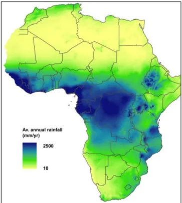
Figure 1.2: Annual rainfall across Africa... 2
Figure 1.3: Average annual rainfall on the Nile countries ... 3
Figure 1.4: Main inputs and outputs of water budget in Egypt... 4
Figure 1.5: Changes in water table depth in western Nile Detla from 1960 to 2000 ... 5
Figure 1.6: Location map of Wadi El-Natrun ... 7
Figure 1.7: Location map of Wadi El-Natrun and its hypersaline lakes ... 10
Figure 2.1: Lithostratigraphic section of Wadi El-Natrun ... 26
Figure 3.1: Distribution of Earth’s water ... 32
Figure 3.2: Satellite image of Wadi El-Natrun ... 35
Figure 3.3. Aquifer system in Egypt ... 36
Figure 3.4: Surface water systems in the north and east of the study area ... 39
40 Figure 3.5: Geological/hydrogeological cross-section of the shallow aquifers between Rosetta branch and Wadi El-Natrun ... Figure 3.6: Distribution of hyper-arid, arid and semi-arid regions along the globe ... 44
Figure 3.7: NASA Earth Observatory map ... 45
Figure 3.8: Regional population distribution over different depths to groundwater ... 46
Figure 3.9: Aquifer productivity (Liters per second) ... 48
48 Figure 3.10: Storage of groundwater for Africa based on the effective porosity and saturated aquifer thickness ... Figure 3.11: Thickness of saturated aquifer thickness across Africa ... 49
Figure 3.12: Estimation to depth to water in Africa ... 49
Figure 3.13: Lake levels distribution across Africa 9000 yrs. BP ... 51
55 Figure 3.14: Map of Africa and land distribution ... 56 Figure 3.15: Map of Africa 5000 BP ... Figure 4.1: Diagram of δ²H and δ¹⁸O fractionation ... 75
Figure 4.2: Linear relationship between δ²H and δ¹⁸O in global precipitation ... 77
Figure 4.3: Diagram of δ²H and δ¹⁸O in natural waters ... 79
83 Figure 4.4: Schematic graph of mechanism of water loss from aquifer... Figure 4.5: Relationship between δ²H and δ¹⁸O of different water resources in Egypt ... 84
Figure 4.6: Location of the studied wells ... 87
Figure 4.7: Contour map of surface elevation of the study area ... 88
Figure 4.8: Contour map of wells depth in the area of study ... 89 Figure 4.9: Piper diagram of the chemical composition of the studied samples ... 98
99 Figure 4.10: Schoeller diagram of the chemical compositions of the studied samples ...
Figure 4.11: Average stable isotopic composition of the studied well... 101
101 Figure 4.12: Stable isotopic composition of the studied wells along different sampling
times...
102 Figure 4.13: Stable isotopic composition (δ²H and δ¹⁸O) of the studied wells and major
recharging sources in Egypt ...
Figure 4.14: Total dissolved solids in the studied wells ... 103 Figure 4.15: Distribution of the studied wells on basis of salinity in... 103 Figure 4.16: Contour map of W-E index ratio in the studied wells. 105
Figure 4.17: US salinity classification for irrigation ... 108 Figure 4.18: Water sources contribution in recharge of the studied wells... 110 Figure 4.19: Relationship observed in variation of salinity and hydrogen isotopic content 111
113 Figure 4.20: Schematic graph showing the variation between salinity and hydrogen
isotopic content along different sampling periods...
113 Figure 4.21: A relationship found in the present study ...
Figure 4.22: Showing difference between the two types of aquifers in water suction... 115 Figure 4.23: The geographic distribution of stable and nonstable wells in the study area... 117 Figure 4.24: Schematic graph showing stable and nonstable wells... 118
LIST OF TABLES
Page
Table 1.1: Summary of meteorological data in the study area and near counterparts ... 9
Table 3.1: Distribution of water resources ... 33
Table 3.2: Distribution of water resources ... 33
Table 3.3: Water resources availability and usage in Egypt ... 34
Table 3.4: Hydraulic parameters in Wadi El-Natrun ... 42
76 Table 4.1: The isotopic ratios of water in natural reservoirs... 84 Table 4.2: Stable isotopes values of various water resources in Egypt... 84 Table 4.3: Different authors who studied water resources in Egypt ... Table 4.4: Field measurements of the studied wells during March 2018... 88
Table 4.5: Uncertainty of different measured elements... 90
Table 4.6: The natural abundances of oxygen and hydrogen isotopes... 92
Table 4.7: Field measurements of the studied wells during March 2018... 93
Table 4.8: Measured elements of the collected samples during December 2014... 94
Table 4.9: Measured elements of the samples collected during February 2016... 94
Table 4.10: Measured elements of the collected samples during July 2016... 95
Table 4.11: Measured elements of the collected samples during November, 2016... 95
Table 4.12: Measured elements of the collected samples during March 2018... 96
100 Table 4.13: Distribution of D (‰) and ¹⁸O (‰) in the studied wells along five sampling times... Table. 4.14: Comparison of studied water samples... 106
Table 4.15: Standard classification according to sodium and salinity hazards... 107
Table 4.16: Possible mechanisms of water removal... 114
Table 4.17: Comparison between group Ⅰ and group Ⅱ wells from observed data ... 116
Table 4.18: Comparison between unstable and stable wells... 116
LIST OF ABBREVIATIONS
micromhos per centimeter μmhos/cm
milliequivalents per liter meq/1
milligrams per liter mg/1
change in ratio of hydrogen isotopes (²H : ¹H), relative to a standard δ²H change in ratio of oxygen isotopes (¹⁸O :¹⁶O), relative to a standard δ¹⁸O
Billion Cubic Meter BCM
National Oceanic and Atmospheric Administration NOAA
National Climatic Data Center NCDC
African Humid Period AHP
International Atomic Energy Agency IAEA
Global Meteoric Line GMWL
Total dissolved solids TDS
World Health Organization WHO
Food and Agriculture Organization FAO
International Desalination Association IDA
North Western Sahara Aquifer System NWSAS
Nubian Sandstone Aquifer System NSAS
Center for Environment and Development for Arab Region and Europe CEDARE
International Union for Conservation of Nature IUCN
Ministry of Water Resources and Irrigation MWRI
The General Company for Research and Groundwater REGWA
Research Institute of Groundwater RIGW
National Aeronautics and Space Administration's NASA
Continental Oil and Transportation Company. CONOCO
Intergovernmental Panel on Climate Change IPCC
The Global Network of Isotopes in Precipitation GNIP
Liquid Water Isotope Analyzer LWIA
X-ray diffraction XRD
X-ray fluorescence XRF
CHAPTER 1 INTRODUCTION 1.1 Overview
Egypt is situated between latitudes 22° and 32°N and longitudes 24° and 36°E in the extreme North-Eastern corner of the African Continent; bordering the Mediterranean Sea, between Libya and the Gaza Strip, the Red Sea, north of Sudan and embraces the Asian Sinai Peninsula serving a land bridge between Asia and Africa (Figure 1.1). The majority of landscape is desert with narrow arable land. Egypt possesses a fast steadily growing population during the last few decades with a restricted distribution of population around the River Nile. Tremendous efforts are carried out by the government to face the demand of Egypt's population through economic reform and huge investment in communications and physical infrastructure (Cia. Gov., 2018).
Figure 1.1: Location map of Egypt (NASA, 2000).
22 °N 32 °N
36 °E 24 °E
1. 2 Motivation
Water scarcity is a crucial crisis facing humankind especially in arid and semi-arid regions.
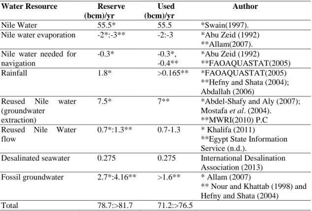
Egypt suffers from water shortage (Figures 1.2 and 1.3). The scarcity of water will be even more critical in the future. Modernization and increasing of water needs for industrial, agricultural, and human daily usage representing extreme pressure on the available water resources. There are concerns towards food and water security and Egypt is extremely vulnerable. The threshold value of water scarcity is 1000 m³/capita/year. Egypt has passed that threshold already in nineties and is expected to drop to only about 600 m³/capita/year (MWRI, 2005). Therefore, groundwater is the main source for drinking water in Nile countries (Masiyandima and Giordno, 2007). The cultivated areas in Egypt have been increased over the past three decades. In the coming decades, the optimum challenge will be the task of increasing food production despite the limited water resources, especially in arid and semi-arid regions (FAO, 2003).
Figure 1.2: Annual rainfall across Africa (Macdonald, 2009) from using data from New et al.
(1999).
Figure 1.3: Average annual rainfall on the Nile countries (FAO, 1997).
The Nile River is the only reliable renewable water supply in Egypt providing more than 95% of freshwater as it consumes nearly its entire share from the Nile River water depending on it for drinking and irrigation therefore, different renewable water resources should accompany agricultural land expansion (Said, 1993; Hamza and Mason 2004; Antipolis, 2011). At the present time, water shortage lies ahead as a consequence of political disputes around Nile River treaties and the establishment of Renaissance Dam making it an important domestic and international political issue for Egypt recent international negotiations over allocations throughout the river Nile Basin.
The population overgrowth is one of the crucial national problems facing the Egyptian government. Egypt is ranked 14th in the list of countries by population with a population of approximately 98 million with about 1.8 million increase annually. Furthermore, the population is expected to reach 119 million by the year 2030 and 153 million by the year 2050 (Worldometers,
2017). Most of the population and economic activity are concentrated in the highly fertile Nile Valley and Nile Delta, which makes up around 5% of Egypt's total area.
Groundwater is used in association with surface water in the areas bordering the Nile Delta.
On the other hand, in regions like the Western Desert where water is scarce, groundwater constitutes a principal portion of water supply and the pressure on it is increasing as the River Nile can’t cover the increased demands. The government policy is to increase the reclaimed lands using groundwater for planting high standard crops for exportation to Europe and Middle East.
National Water Resources Plan expanding the cultivated area by 3.4 million hectares.
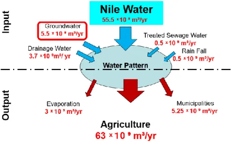
Reclamation projects were started by new agricultural communities to meet the needs of the increasing population away from the Nile Delta and Nile River valley and to get over the desertification phenomena in Egypt. The expansion in land reclamation is greatly assisted by private investors using groundwater for irrigation (ex. Toshka, El Salam Canal, Ain Dalla, Farafra, and the million and half feddans projects). Consequently, the cultivated areas in Egypt have been increased over the past three decades. Agriculture is the chief consumer of water in Egypt representing around 63 BCM of the total demand (Figure 1.4).
Figure 1.4: Main inputs and outputs of water budget in Egypt compiled after Allam (2001).
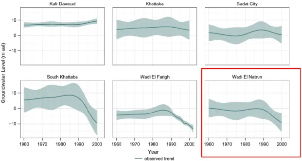
Land reclamation activities around the Nile Delta, Western Desert and Sinai have been largely extended leading to great pressure on groundwater and serious drawdown in water level (Figure 1.5). Depletion of groundwater resources and mismanagement resulted in a growing concern on the sustainability of available water resources.
Figure 1.5: Changes in water table depth in Western Nile Delta from 1960 to 2000 (Baietti et al., 2005; Ibrahim, 2005).
The groundwater table has fallen and salinity problems has arisen as a consequence of excessive extraction and a quick drop of productive land are expected over the period 2007-2025 (World Bank, 2007). The unfavorable environmental impacts on social and economic aspects constitute a massive pressure on the infrastructure. Wadi El-Natrun region has no other choice but to plan for an economically and environmentally sustainable development in accordance with hydrologic research as water resources management and assessment is important for acquiring better water including quality and quantity.
A successful management is needed to sustain the continuity of those projects. The acquisition of sufficient knowledge about the aquifer facilitate the way to an adequate management strategy to a rational use of the resources.
This thesis introduces an approach for the impacts of dry land environmental change on groundwater over time (four years). A particular focus is placed on isotopic analysis and geochemistry of groundwater used to assess the impact of seasonal variations on groundwater in Wadi El-Natrun.
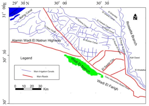
1.3 Study Area
Wadi El-Natrun attracted the attention because it is a part of extreme arid province (Meig, 1953). It’s a part of Saharian zone (Emberger, 1955). Wadi El-Natrun is a part of the Western Desert adjacent to the Nile Delta, a prominent endorheic elongated narrow depression (oval trough-like with gentle flanks) west of Cairo-Alexandria Desert Road and parallel to it approximately 90 km south of Alexandria and 110 km northwest of Cairo. It attains a length of about 50 km and a width ranging from 5 to 10 km, wide in the middle (8 km) and narrower at both ends (2.6 km in the north and 1.24 km in the south). It is bounded by longitudes 30° 10´ 19´´
and 30° 37´ 6.3´´ E and latitudes 30° 13´ 51´´ and 30° 36´ 13´´ N almost parallel to the Rosetta Branch of the Nile around 50 km from it (Figure 1.6). The bottom of Wadi El-Natrun is 23 m below sea level and 38 m below the water-level of the Rosetta Branch of the Nile.
Figure 1.6: Location map of Wadi El-Natrun.
Wadi El-Natrun is one of the first selected areas as a new reclamation site since Late Fifties, tempting people who induced land development as it’s a promising area for agricultural activities due to the existence of ground water, its low relief topography and good accessibility. The general lowland area of the depression is about 50 m below the level of its borders (Abd El Malek and Rizk, 1963).
Wadi El-Natrun covers an area of around 272 km², the lowest part of the depression, encircled by contour zero, inland saline lakes and salt encrustation occupy the area surrounded by contour zero (Abu Zeid, 1984). One of the conspicuous features in the Wadi El-Natrun depression are the natural water lakes, located at about 23 m below sea level. The area of Wadi El-Natrun has always been confined as a possible area for reclamation and utilization due to its location, accessibility, investment facilities provided by the government and the presence of groundwater
in a good quality for irrigation. The area has been mapped several times for oil and groundwater perspectives.
The name Wadi El-Natrun was introduced by an Arab traveler named El-Maqurizi in the 16th Century. The word Natrun is derived from the Latin word “natrium” for the element sodium. The history of the area dates back to the Pharaohs, who used salts from the lakes for the process of mummification, they called it Ain Horus, which means the eye of the God Horus because it appears to be shaped like an eye The Romans extracted silica for glass as well. During the British occupation of Egypt, railroad system was built to move the salt from Wadi El-Natrun to Cairo.
Wadi El-Natrun is known for the presence of evaporites that are used in various industries (Lucas and Harris, 1962). Wadi El-Natrun was famous as a source for building materials to the biggest two cities in Egypt, Cairo and Alexandria (Abu Zeid, 1984).
1.4 Climate
The main feature of the Egyptian climate is the almost uniform aridity. The climate of Wadi El-Natrun is dominated by arid to semi-arid climatic conditions (low and very variable rainfall, a long dry summer, a high rate of evaporation, and low humidity and a short temperate Winter).
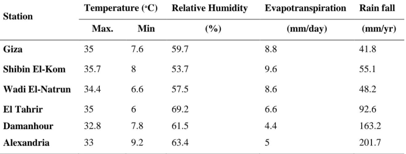
Wadi El-Natrun is characterized by annual rainfall of 41.4 mm, evaporation rate 114.3 mm and average temperature is 21 C°, wind speed average is 3.4 m s-¹ and the mean relative humidity is 48%. Hence, this province is found to be very arid (Egyptian Meteorological Authority, 2006) winds are usually from the north, northeast and northwest. The majority of rain falls during December, January, and February (Switzman, 2013). According to NOAA’s National Climate Data Centre (NCDC) dataset of Wadi El-Natrun, the average daily precipitation is 31.5 mm as recorded from 1996 to 2012. The depression secures a relatively sheltered climate unlike the surrounding desert area. Mean annual rainfall reaches 55 mm (Zahran and Willis, 2009).
Table 1.1: Summary of meteorological data in the study area and near counterparts (Egyptian Meteorological Authority, 2006).
Station Temperature (∘C) Relative Humidity Evapotranspiration Rain fall
Max. Min (%) (mm/day) (mm/yr)
Giza 35 7.6 59.7 8.8 41.8
Shibin El-Kom 35.7 8 53.7 9.6 55.1
Wadi El-Natrun 34.4 6.6 57.5 8.6 48.2
El Tahrir 35 6 69.2 6.6 92.6
Damanhour 32.8 7.8 61.5 4.4 163.2
Alexandria 33 9.2 63.4 5 201.7
1.4.1 Evaporation and evapotranspiration
Evaporation is the transfer of liquid water into the atmosphere. The area is characterized by a high rate of evapotranspiration. The average actual evapotranspiration ranges from about 9 mm/day in the south to about 4.4 mm/day in the north and from Summer to Winter.
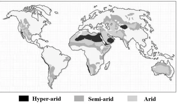
The average meteorological data in the study area and major surrounding cities were provided by the Egyptian Meteorological Authority from six metrological stations (Table 1.1) in Giza, Shibin El-Kom, El-Tahrir, Wadi El-Natrun, Damanhour and Alexandria. The total reference of evapotranspiration is 1515 mm/yr which equals 0.021 aridity index and classified as hyper-arid (United Nations Environment Programme, 1992). The daily evaporation of open water varies from approximately 1.5 mm to 7.5 mm in December and in July, respectively. about ~1600 mm/year (Geirnaert and Laeven, 1992).
1.5 Lakes
Egypt possesses few natural inland lakes. The inland saltmarshes are found as Sabkhas around springs, lakes, and wells of the Western Desert Oases and Depressions (Siwa, Dakhla, Kurkur, Dungul, Baharia, Farafra, El Fayoum, Qattara, Wadi El-Natrun, etc…) (Zahran, 1972).
Saline lands constitute around 10% of the Earth’s land surface (O’leary and Glenn, 1994).
A chain of seven large alkaline, hypersaline lakes in addition to a number of ephemeral pools extends along Wadi El-Natrun, parallel to its axis (Figure 1.7).
Figure 1.7: Location map of Wadi El-Natrun and its hypersaline lakes.
The lakes have attracted many workers due to their sensitivity to climatic changes. The saline water environment of Wadi El-Natrun bear similarity to that found in Playa-ephemeral lakes and perennial saline lake complexes shown elsewhere. Evaporation removes surface waters effectively and produce concentrated brine progressively (Eugester and Hardie, 1978; Lent and Lyons, 1995).
Wadi El-Natrun lakes were exploited as main source of natron in the ancient world. Natron was used in the process of mummification by the ancient Egyptians (James and Slaughter, 1974;
Omara and Sanad, 1975). It occurs as solution in lake water, deposits on their bottom, and crust around edges of the lakes (Zahran and Willis, 2009). In addition, natron was used in glass production from archaeological evidences just beside the lakes of Wadi El-Natrun under the reign
of Roman empires (Neena, 2003). Wadi El-Natrun is now no longer exploited for torona instead halite is exploited from a very small lake (Nakhla et al., 1986).
Various environments and climatic changes are preserved in the lakes of Wadi El-Natrun.
Wadi El-Natrun is considered as an alkaline environment of athalassohaline system which results from non-sea water sources and contains different ion ratios (Satyanarayana et al., 2005). It lies 23 m below sea level and is characterized by a series of small disconnected lakes in the bottom of the Wadi. Some of these lakes are relatively larger in size and have permanent water reservoirs in all or some of their parts. Chemical and physical conditions in the lakes are affected by changes in evaporation and precipitation. Various plants are found at the edge of the lake area nearby water edge along marsh lands.
The lakes are named (El Fasda, Umm Risha, El Razonia, Abou Gebara, El Hamra, El Zugum, El Zaagig, El Beida, El Khadra, Gaar, El Sabkha and Afauna). They occur approximately along the longitudinal axis of Wadi El-Natrun (Gaar Lake, about 2.4 km²; El Bida Lake, about 2.3 km²;
El Zugum Lake, about 1.6 km²; El Hamra Lake, about 1.1 km²; El Razonia Lake, about 0.87 km²;
Umm Risha Lake, about 2.45 km² and El Fasda Lake, about 0.72 km²). All of the lakes are below sea level with the lowest in Gaar Lake (-23 m) and the highest in El Khadra Lake (-19 m). The water level changes around the year with relatively higher in Autumn and Winter and lower in Spring and Summer (El-Fayoumy, 1964). The largest lakes are Gaar Lake in the northwest side of the depression and Lake Umm Risha Lake in the southeast direction.
The evaporitic lakes vary in size depending on their position in the wadi and the climate. The level of the water in these lakes fluctuates seasonally, becoming higher in winter and lower in summer. In Summer, the smaller lakes dry up completely, and only few pools are left (Atia et al., 1970). Other smaller, but almost permanent, lakes are El Hamra, El Fasda, El-Bida, El Khadra, El Zugum (Zaagig) and Abou Gebara.
The number of lakes is contradictory due to high rate of evaporation as Stocker (1927) recorded 16 lakes, El-Hinaawi and Atwa (1973) mentioned 10 lakes and Imhoff et al. (1979) noted the presence of only 6 lakes. Zahran and Willis (2009) recorded 8 principal lakes present along 30 km long axis of the depression lying from northeast to southwest as follows: El Gaar, El Khadra, El Bida, El Zugum, El Hamra, Abou Gebara, Al Razonia, Umm Risha, and El Fasda.
Halite is most common mineral in most of the lakes along most of the year. Trona (a sodium carbonate-dehydrate mineral) occurs in the lakes in exploitable quantities in some lakes. It is rarely found as pure, single-phase trona (Atia et al., 1970; Shortland, 2004).
The western part of the lakes is frequently occupied by aeolian sand. The largest lakes are Lake El Gaar in the northwest and Lake Umm Risha in the southeast direction. The depth of the lakes ranges from 0.5-2 m due to seasonal changes in evaporation and seepage influx (Mesbah et al., 2007).
The lakes of Wadi El-Natrun have pH values of 11 with salt contents more than 30%
comprising sulphates, carbonates, chlorides, sodium, and minor amounts of potassium and traces of calcium and magnesium (Johaness et al., 1979). Wadi El-Natrun is an outstanding aquatic ecosystem among saline lakes distinguished by hyper salinity and alkalinity poor in (NO₂⁻, NO₃⁻SiO₂ and Ca²⁺, Mg²⁺, K⁺, and rich in Cl⁻, SO₄²⁻, Na⁺, CO₃²⁻, HCO₃⁻, and PO₄²⁻). The productivity and distribution of aquatic life is affected by water chemistry and lake depth (Taher, 1999; Sayed and Abdo, 2009). The geochemical and biological characteristics of evaporation need to be considered in the study of inland saline lakes. The maximum water level is observed between December and March and the lowest level is during Summer season. The lakes water shows a high alkaline nature (pH ranges from 9.12 to 9.85), with very poor oxygen.
1.6 Previous Work
Recently and during the past few decades Wadi El-Natrun and its alkaline saline lakes have been of great importance. The area of Wadi El-Natrun has been studied by numerous eminent authors dealing, in particular, with the geology and hydrogeology, microbiology and geochemistry of the lakes. Various environments and climatic changes are preserved in the lakes.
Wadi El-Natrun is one of the oldest centers of monastic settlements in Egypt continuing from the period between the 4th and 6th Century and four monasteries are inhabited at present (Moussa et al., 2009). The following is a brief history of studies that were conducted on Wadi El-Natrun in chronological order:
The study of Wadi El-Natrun was stared by Andrews (1902) who described the vertebrate fauna collected from Qaret El Muluk in the area of Wadi El-Natrun. Hume (1925) compiled geological logs for some water wells sunk in Wadi El-Natrun from the data from the “Salt and Soda Company”.
Geoistrazivanja (1962) reported the results of test drilled wells and four production wells in the Western Desert and along the Cairo- Alexandria Desert Road, respectively. Shata et al. (1962) illustrated that the south eastern part of Wadi El-Natrun is hydraulically connected to the Nile behind the Barrage South of Cairo, hence are chemically similar. White et al. (1963) reported that the water of Wadi El-Natrun is less carbonated than Nile waters. The groundwater of Wadi El- Natrun are recycled water (meteoric waters). According to the salinity classification water is good potable. The seasonal changes in Wadi El-Natrun is indicated by increase in salinity from August to December and then decreases to a minimum in June.
El-Hinnawi and Atwa (1973) classified the groundwater of Wadi El-Natrun as good potable to fresh waters belonging to sodium bicarbonate and Ca-Mg bicarbonate classes.
Abdel Baki (1983) elucidated that the Lower Miocene aquifer is recharged from southern section of the Nile Delta basin whilst Wadi El-Natrun and Moghra depression in the northwest and west are recharged from the Lower Miocene aquifer.
Abu Zeid (1984) studied 25 vertical stratigraphic sections representing the outcrops of Wadi El-Natrun, in addition to collecting macro and microfossils from beds of the studied sections.
Farid (1984) argued the various plans for the development of groundwater in the Nile Delta area.
Geirnaert and Laeven (1992) discussed the composition and groundwater history of groundwater in area west of the Nile Delta. Ahmad (1993) pointed out that groundwater moves from east to west across Wadi-El Farigh and is managed by an old buried Nile channel which deflects the flow of groundwater towards Wadi El-Natrun Depression. Fekry (1993) predicted the lowering in groundwater heads south and east of Wadi EI-Natrun by 10 m and up to 15 m in the span of 50 years as a result of the massive expansion in reclamation projects.
Gomma (1995) classified the water types of the Pliocene aquifer NaHCO₃ and NaCl water types. Mohamed (2002) studied the change in land use in the western delta between 1987 and 1998 and its effect on groundwater. Dawoud et al. (2005) made a GIS based model for the aquifer system at a study area west of the Nile Delta, he showed that the enhancement of irrigation system could decrease the annual aquifer potentiality by approximately 91% as a result of minimizing the infiltration rates. Gaame (2005) associated the deterioration of groundwater in wells west of Nile Delta region especially, on the Wadi El-Natrun and Wadi El-Farigh areas to poor well design, and over-pumping.
1.7 Objectives of the Study
The objectives of the current study can be summarized as follows:
1. Assemble ground-water quality data along successive four years.
2. Hydrochemical characterizations of the groundwater, identifying major anions and cations.
3. Identify origin of the groundwater using ¹⁸O and ²H isotopes to determine recharging sources.
4. Mechanism controlling variation among wells.
5. Evaluation of the groundwater suitability for different purposes.
This thesis is composed of five chapters which investigate the hydrogeology of Wadi El- Natrun. (1) Chapter one introduces an overview, previous work and objectives of the research.
(2) Chapter two describes the geomorphology, structure and stratigraphy. (3) Chapter three handles occurrence of the groundwater in Sahara and an overview of the Holocene climatic changes in Africa and Egypt. (4) Chapter four deals with the geochemistry of groundwater, suitability for domestic and agricultural purposes and isotopic data that characterize sources of groundwater in the aquifer. (4) Chapter five introduces the water crisis and current situation with proposed solutions.
BIBLIOGRAPHY
Abd el Malek, Y. and Rizk, S.G. (1963). Bacterial sulphate reduction and the development of alkalinity. III. Experiments under natural conditions in the Wadi El-Natrun. Journal of Applied Bacteriology, 26 (1): 20-26
Abdel Baki, A. M. A. (1983). Hydrogeological and hydrogeochemical studies in the area west of Rosetta Branch and south El Nasr Canal, Ph. D. Thesis, Fac. Sci., Ain Shams University, 156 p Abu Zeid, K.A. (1984). Contribution to the geology of Wadi El-Natrun area and its surroundings.
M.Sc. Thesis, Fac. Sci., Cairo University
Aeschbach-Hertig, W. and Gleeson, T. (2012). Regional strategies for the accelerating global problem of groundwater depletion. Nature Publishing Group, 5 (12): 853-861
Ahmad, N. E. M. (1993). Hydrogeological studies on Wadi El- Farigh area, Western Desert, Egypt.
M. Sc. Thesis, Geol. Dept. Fac. Sci. Menoufia University
Allam, M.N. (2001). Water and agriculture land in Egypt. 3rd World Forum, Academic Press, Cairo, Egypt
Andrews, C.W. (1902). Note on a Pliocene vertebrate fauna from the Wadi El-Natrun, Egypt.
Geol. Mag. (London), 9: 433-439
Antipolis, S. (2011). Water use efficiency and economic approach. CEDARE / Plan Bleu
Atia, A. K. M., Hilmy, M. E. and Bolous, S. N. (1970). Mineralogy of the encrustation deposits of Wadi E1-Natrun. Desert Inst. Bull., (2): 301-325
Attia, F., Fahmy, H., Eid, M., Hoevenaars, J. and Slootweg, R. (2007). The west Delta water conservation and irrigation rehabilitation project (WDWCIRP). E1572. 2nd ed
Baietti, A., El Dia, Q., Requena, S.A., El Arabi, N., Nassar, A. and Hamid, A.W.A. (2005).
Conceptual framework and transaction model for a public-private partnership in irrigation in the west Delta, Egypt. Ministry of Water Resources and Irrigation, Arab Republic of Egypt.
Cia. Gov. (2018). The World Factbook. Africa: Egypt. Geography. Washington: Central Intelligence Agency. Available in: https://www.cia.gov/library/
Dawoud, M. A., Darwish, M. M. and El-Kady, M. M. (2005). GIS-based groundwater management model for western Nile Delta. Water Resources Management, 19 (5): 585-604 Egyptian Meteorological Authority (2006). Int. Journal of Meteorology Cairo, Egypt, 31: No. 308 El-Din, M. M. N. (2013). Climate change risk management in Egypt. UNESCO, Cairo
El-Fayoumy, I.F. (1964). Geology of groundwater supplies in Wadi El-Natrun area. M.Sc. Thesis, Fac. Sci., Cairo University, Egypt, 200 p
El-Hinnawi, E. E. and Atwa, S. M. (1973). Geochemistry of ground waters from some localities west of the Nile Delta. Geologische Rundschau, 62: 225-245
Emberger, L. (1955). Afrique du Nord-Desert, ecologievegetale. Comptesrendus de Recherches.
Plant Ecology, Rev. of Res., Paris, UNESCO: 219-249
Eugster, H. and Hardie, L.A. (1978). Saline lakes. In: Lerman, A. (ed.), Lakes: Chemistry, Geology, Physics, Springer, New York: 237-293
Farid, M.S. (1984). Management of groundwater system in the Nile Delta, Ph.D. Thesis, Fac. Eng.
Cairo University, Egypt, 250 p
Fekry, A.M. (1993). Hydrogeological studies on the southern region of the Nile Delta. Ph. D.
Thesis, Fac. of Sci., Ain Shams University, Cairo, Egypt, 121 p
Food Agric. Organ. (1997). Irrigation potential in Africa: A basin approach FAO land and water Bull., 4
Food Agric. Organ. (FAO) (2003). Groundwater management-the search for practical approaches.
Water Reports, 25. Rome
Geirnaert, W. and Laeven, M.P. (1992). Composition and history of groundwater in the western Nile Delta. Journal of Hydrology, 138 (Issues 1-2): 169-189
Geoistrazivanja (1962). Comprehensive technical report about test wells in the Western Desert fringes. Report Presented to Ministry of Public Works
Giordano, M. (2009). Global groundwater? issues and solutions. Annu. Rev. Environ. Resour., 34 (1): 153-178
Gomaa, M.A. (1995): Comparative hydrogeological and hydrochemical study on some aquifers, west of Nile Delta, Egypt. Ph. D. Thesis, Fac. of Sci., Ain Shams University; Cairo, Egypt, 236 p
Hamza, W. and Mason, S. (2004). Water availability and food security challenges in Egypt.
Proceedings International Forum on Food Security Under Water Scarcity in the Middle East:
Problems and Solutions. Como, Italy: 24-27
Hardie, L.A., Smoot, J.P. and Eugster, H.P. (1978). Saline lakes and their deposits: a sedimentological approach. In: Matter, A. and Tucker, M.E. (ed.), Modern and ancient lake sediments, International Association of Sedimentologists, Special Publication, 2: 7-41 Hume, W.F. (1925). Geology of Egypt, the surface features of Egypt, their determining causes
and relation to the geological structures. Surv. and Mines Dept., Cairo, 1
Ibrahim, S. (2005). Groundwater resourcesmanagement in Wadi El-Farigh area and its vicinities for sustainable agricultural development. Fac. Eng., Ain Shams University, Cairo, Egypt Imhoff, J.F., Sahl, H.G., Soliman, G.S.H and Trüper, H.G. (1979). The Wadi El-Natrun; chemical
composition and microbial mass developments in alkaline brines Eytrophic desert lakes.
Geomicrobiol., (1): 219-234
James, G.T. and Slaughter, B. (1974). A primitive new middle Pliocene murid from Wadi El Natrun, Egypt. Ann. Geol. Surv. Egypt, 4: 333-362
Lent, R.M. and Lyons, W.B. (1995). Pore water geochemistry and solute flux from bottom sediments, Devils Lake, North Dakota. International Journal of Salt Lake Research, 3(2): 113-135
Lucas, A. and Harris, J.R. (1962). Ancient Egyptian materials and industries, Dover Publications, London
MWRI (2005). National water resources plan for Egypt 2017. Ministry of Water Resources and Irrigation
Macdonald, A. (2009). What will climate change mean for groundwater supply in Africa? - ODI Background Notes, March
Masiyandima M. and Giordano M. (2007). Sub-Saharan Africa: opportunistic exploitation. In:
Giordano, M. and Villholth, K.G. (ed.). The Agricutural Groundwater Revolution:
Opportunities and Threats to Development, CABI, Wallingford, UK: 79-99
Meig, P. (1953). World distribution of arid and semi-arid homoclimates, Arid Zone Hydrology, UNESCO, Paris
Mesbah, M. N.; Abou-El-Ela, S., H; Wiegel, J. (2007). Novel and unexpected prokaryotic diversity in water and sediments of the alkaline, hypersaline lakes of Wadi El-Natrun, Egypt.
Microb. Ecol., 54: 598-617
Mohamed, M.A. (2002). Study of groundwater development in the western Delta by using the remote sensing and GIS, Egypt. M.Sc. Thesis, Fac. of Eng. Shoubra-Zagazig University, Cairo, 116 p
Moussa, A. B., Kantiranis, N., Voudouris, K. S., Stratis, J. A., Ali, M. F. and Christaras, V. (2009).
Diagnosis of weathered Coptic wall paintings in the Wadi El-Natrun region, Egypt. Journal of Cultural Heritage, 10: 152-157
NASA (2000). The Nile River and delta Sinai Peninsula and Red Sea, Egypt, from MODIS.
Credit: Jacques Descloitres, MODIS Land Science Team
https://eoimages.gsfc.nasa.gov/images/imagerecords/54000/54842/Egypt.A2000060.0855.
1800x2350.jpg
NOAA (2010). JetStream: Online school for weather. January, 2010 http://www.srh.noaa.gov/jetstream/global/climate_maxhtm.
Nakhla, F.M., Saleh, S.A. and Gad, N.L. (1985). Mineralogy, chemistry and paragenesis of the thenardite (Na₂SO4) deposit in Beida Lake, Wadi El-Natrun, Egypt. Applied Mineralogy:
1001-1013
Neena, M.D. (2003). Un nouvel atelier primaire dans le Wadi Natrun (Égypte), et les compositions des verres produits dans cette region. Bull. de l’Association française pour l’Archéologie du verre: 21-24
New, M., Hulme, M. and Jones, P. D. (1999). Representing 20th Century space-time climate variability. Part1: development of a 1951-90 mean monthly terrestrial climatology, Journal of Climate, 12: 829-856
Omara, S. and Sanad, S. (1975). Rock stratigraphy and structural features of the area between Wadi El-Natrun and the Moghra Depression (Western Desert, Egypt). Geol Jb., 16: 45-73 O’Leary, J. W. and Glenn, E. P. (1994). Global distribution and potential for halophytes. In:
Halophytes as a resource for livestock and for rehabilitation of degraded lands
Said, R. (1993). The Nile River: Geology, Hydrology, and Utilization. Pergamon, New York, USA Satyanarayana, T., Raghukumar, C., and Shivaji, S. (2014). Extremophilic microbes: Diversity
and perspectives, SCIENCE, 89 (1): 78-90
Sayed, M. F. and Abdo, M. H. (2009). Assessment of environmental impact on, Wadi El-Natrun Depression lakes water, Egypt. World Journal of Fish and Marine Sciences, 1 (2):129-136 Shata, A.A., Pavlov, M. and Saad, K.F. (1962). Preliminary report on the geology, hydrogeology,
and groundwater hydrology of Wadi El-Natrun and adjacent areas. Internal Report. Desert Inst., Cairo, 159 p
Shortland, A. J. (2004). Evaporites of the Wadi Natrun: Seasonal and annual variation and its implication for ancient exploitation. Archaeometry, 46:497-516
Stocker, O. (1927). Das Wadi El-Natrun. In: Karston, G. and Schenk, K. (eds). Vegetation sbilder, 18 Reihel
Switzman, H. (2013). The Impact of environmental change and water conservation on dryland groundwater resources in northern Egypt: Modeling Aquifer Response Using Sparse Data.
Department of Civil Engineering, McMaster University
Taher, A. G. (1999). Inland saline lakes of Wadi El-Natrun Depression, Egypt. International Journal of Salt Lake Research, 8: 149-169
The World Bank (2007): West Delta water conservation and irrigation rehabilitation project.
Report No. 32393-EG
UNEP-United Nations Environment Programme (1992). World atlas of desertification. London., 69 White, D.E., Hem, J.D. and Waring, G.A. (1963). Chemical composition of subsurface water. In:
Data of Geochemistry, 6th ed. U.S. Geol. Surv., Prof. Pap. 440F
Worldmeters (2017). www.worldometers.info/world-population/egypt-population/
Zahran, M. A. (1972). on the ecology of Siwa Oasis, Egypt. Egypt. J. Bot., 15(2): 223-242.
Zahran, M. A. and Willis, a. J. (2009). The vegetation of Egypt (Plant and Vegetation) 2nd ed.
Springer, 437 p
CHAPTER 2
STRATIGRAPHY 2.1 Geomorphology
The area of west Nile Delta is distinguished by its mild topography and low relief. Wadi El- Natrun possess a desert geomorphology, it has aeolian sand accumulation which reaches 10 m thickness (El Fayoumy, 1964). The area is composed of four major geomorphologic units; alluvial plains, structural plains, tablelands and shifting sand (Shata, 1962; Attia, 1975; Omara and Sanad, 1975; Abdel Baki 1983).
The origin of the Wadi El-Natrun depression and its lakes was attributed to erosional processes accompanied by lowering of water table (El Fayoumy, 1964). Wadi El-Natrun is separated from Wadi El Farigh from southwest by Gebel El Mikheimin an elongated irregular scarp. The floor of Wadi El-Natrun is occupied by several mesas and butts composed of sands, clays, and sandstones capped with hard calcareous horizon. The high land areas are barren while vegetation is restricted to low lands.
The lowest part of Wadi El-Natrun is encircled by contour zero where sabkha, white salt encrustation and saline lakes occur (Abu Zeid, 1984). Physiographically, Wadi El-Natrun is composed of three main parts which are northern nilotic ridge, northern foot-slope that reaches 35 m high, and the main depression with its salt alkaline lakes (El-Hinnawi and Atwa, 1973).
Wadi El-Natrun is characterized by the presence of scattered isolated hills (El-Shahat et. al., 1997) such as Qaret El-Muluk (7 m high) and Ras El-Solymania (51 m high) and Bani Salama (50 m high).
2.2 Geological Setting
The structural features of Wadi El-Natrun has been studied by many authors on varying scales. The area of Wadi El-Natrun lies within the unstable shelf of northern Egypt and is structurally affected by the Marmarican Homocline which is dipping gently northward and the
taphro-geosynclinal trough of the Nile Delta (El Fayoumy, 1964; Shata and El Fayoumy, 1970).
The advent of Miocene was marked by a conspicuous tectonic movement that lead to NE-SW fault system in Wadi El-Natrun (Said, 1990).
El-Fayoumy (1964) believed that, Wadi El-Natrun is possibly a graben structure oriented in the NW-SE direction. This graben structure has a length of about 30 km and with an average width of about 10 km. Wadi El-Natrun anticline, the main geological feature, extends for about 35 Km in a northwest direction from Ras El- Solymania in the north to Deir Macarious in the south. The axis passes through most of the lakes of Wadi El-Natrun. Shata (1953) mentioned that the initial formation of Wadi El-Natrun graben structure took place, approximately contemporaneous with other graben structure detected in the Gulf of Suez region.
The west Nile Delta area is separated from the Delta basin by one or more of step faults having an eastern downthrown. Such faults enable the highly permeable Pleistocene deposits of the Nile Delta to meet up with the older sediments due west. Consequently, a westward flow of the Nile water to the western old sediments. The fault system in Wadi El-Natrun area is trending NW-SE parallel to Rosetta branch and the axis of the depression and tangential to the lakes this lineament separates the Miocene and Pliocene well exposed rocks at its southwestern side from the Pliocene and Pleistocene units at its northeastern side (El-Shazly et al., 1975).
General Petroleum Company “GPC” (1977) showed that Wadi El-Natrun area is dominantly affected by seven faults; Wadi El-Natrun faults zone F1, F2 and F3 have downthrown to the east and bounded Wadi El-Natrun unit from the west and El Tahrir Pleistocene unit from the east, fault 4 (F4) has a NW and its downthrown side to the south, fault 5 (F5) trends in NW direction with downthrown to the south. It bounds Wadi El-Natrun unit from the north and Wadi El-Farigh unit from the south, El Khatatba fault (F6) has a general direction in NE and downthrown side to the
north. It bounds Tahrir Pleistocene unit from the north and Wadi El-Farigh unit from the south and fault 7 (F7) extends in downthrown side to the south.
2. 3 Stratigraphy
Wadi El-Natrun rocks are not well exposed and relatively show lack in fossils. Various lithostratigraphic units forms the surface of Wadi El-Natrun and its aquifer systems. The bottom of Wadi El-Natrun is occupied by eleven saline lakes, representing a discharge area. The flow of groundwater is observed from both the east (Nile Delta) and the west (Western Desert) towards the depression (Attia et al., 2007 and RIGW, 1992). Localized flow fields has been developed due to the excessive pumping of groundwater used for irrigation (El-Sheikh, 2000 and Masoud and Atwia, 2010). Wadi El-Natrun is covered by lake deposits and old alluvial deposits of sand and gravel deposited during sea encroachment and the Nile intersect it (Philip et al., 1975). They belong to Quaternary Period. Wadi El-Natrun area is dominated by a sedimentary section which is represented by the oldest Triassic Age to the youngest Pliocene Age with thickness greater than 4 km.
The area west of Nile Delta is distinguished by its mild topography and low relief. It is represented by the Quaternary and Neogene deposits. Quaternary deposits belong to Pleistocene and Recent whereas Neogene deposits are Miocene (subsurface) in age (Said, 1961; Said, 1993).
Wadi El-Natrun is is basically composed of shallow marine, brackish water deposits, and clayey facies at the base and fluviomarine and shallow marine deposits at the top. Pliocene deposits reach up to 150 m. In general, Wadi El-Natrun is covered by sedimentary succession of Oligocene, Miocene, Pliocene and Pleistocene epoch. Oligocene rocks outcrop in area of southwest corner of Nile Delta. Miocene and Pliocene are generally distributed in west and south of Wadi El-Natrun whereas Quaternary sediments dominate towards north.
The surface of Wadi El-Natrun is mainly covered by Pleistocene sands and gravels in addition to, sabkhas and salty crusts along the scattered lakes along its axis. The surface is underlain by Pliocene epoch which is represented by sands, clays, sandy clays, and limestone intercalations and is unconformably underlain by 150 m thick early Miocene rocks (El Hinnawi and Atwa, 1973).
Blanckenhorn (1921) assigned a Late Pliocene age to the beds exposed in Wadi El- Natrun depression. Ball (1939) described the Pliocene rocks of Wadi El-Natrun as of a fluviatile or estuarine origin. These rocks consist of sand and gypseous clay, containing remains of elephants, giraffs and other land animals together with crocodiles and fish. Sandford and Arkell (1939) assigned Plio-Pleistocene to Early Pleistocene times to the gravel terraces of the west Nile Delta.
Shata (1955) has recognized two series belong to the Pliocene in Wadi El-Natrun area. The upper series is composed of porcellaneous limestone with flint, while the lower series is composed of thick shale beds alternating with argillaceous sandstone. The exposed Pliocene rocks at Wadi El- Natrun are divided into the Mikheimin formation (Lower Pliocene) and the Muluk formation (Upper Pliocene) (Abu Zeid, 1984).
The subsurface thickness of sedimentary marine and continental rocks overlying the basement reaches up to (4000 m) (Figure 2.1) according to oil drilling test well No.1 (Phillips, 1970).
Figure 2.1: Lithostratigraphic section of Wadi El-Natrun (Philips, 1970).
Depth
(m) Age Stage Log Lithological Description
Loose quartz sand & green pyritic clay Loose coarse sand with lenses of dark clay
Basalt
Sticky grey clay with occassionally lenses of of quartz sand
Clay and shale, grey stiky dolomitic to very calcareous
Sand
Argiliaceous and chalky limestone with thin bands of chalk
Limestone, greyish green Dolomite
Dolomitic shale and limestone sandy at base
Loose sands with thin lenses of shale
Limestone, grey fine grained microcrystalline oolitic and detrital inclosion
Alternating fine grained limestone and shale with carbonaceous material and coal
Sand and limestone strings grads into argilleous limestone
Basement 100
200 300 400 500 600 700 800 900 1000 1100 1200 1300 1400 1500 1600 1700 1800 1900 2000 2100 2200 2300 2400 2500 2600 2700 2800 2900 3000 3100 3200 3300 3400 3500 3600 3700 3800 3900 4000
Plio. Mio.
OligoceneEocene Upper EoceneM. Eo.Lower Eocene
Cretaceous
U.
Cr.
TuronianCenomanianLower Cretaceous
Jurassic MalmDogger
Triassic
Fig. (3-2): Wadi El Natrun Test Well No. 1 (Compiled after Phillips, 1970)
232 1152 567 840 533 390 190 130
Thick.
Loose quartz sand and green pyritic clay
Lithostartigraphic Descritption
Loose coarse sand with lenses of dark clay
Sticky grey clay with occasionally lenses of quartz sand
Grey sticky dolomitic to very calcareous clay and shale
Argillaceous and chalky limestone with thin bands of chalk
Greyish green limestone Sand
Basalt Basalt
Sand
Dolomite
Grey oolitic limestone
Dolomite shale and sandy limestone at base
Loose sand with thin shale lenses
Alternating fine grained limestone and shale with coal
Basement
Sand and limestone strings grads into argillaceous limestone
The oldest exposed rocks in Wadi El-Natrun area is Miocene rocks, occupying most of the area to south of the wadi (depression) whereas within Wadi El-Natrun depression the surface exposures are dominated by Pliocene shallow marine and continental formations and post Pliocene fluvio-marine deposits. The study of Wadi El-Natrun exposed rocks in addition to drilled wells (surface and subsurface) Shata (1962) divided rocks into three units from exploratory core base 200 m of Miocene shallow marine lacustrine deposits composed of coarse and fine-grained sand followed by Pliocene strata measuring around (200 m) and are divided into two units. Upper calcareous grit and impervious clay whereas the lower unit is dominated by green clays. These two rock units are topped by widely distributed Quaternary and Recent strata. The Quaternary rocks are differentiated into Pleistocene and Recent. Recent rocks are represented from top to base by windblown sands and downwash deposits and silt deposits of the Nile Delta (25 m).
Tertiary rocks are represented by (Oligocene, Miocene and Pliocene) rocks (Abu Zeid, 1984).
The Triassic succession is made up of shale and limestone intercalations whereas the Jurassic strata are mainly composed of limestone and shale with sandstone lenses. The Cretaceous rocks unconformably underlie the Eocene deposits. Cretaceous rocks are divided into lower and upper Cretaceous rocks. The Upper Cretaceous strata are mainly represented by carbonate rocks with shaly facies whereas the Lower Cretaceous strata are dominated by sandy rocks intercalated with clay and cemented by calcite. The Eocene rocks are made up of limestone at the base and topped by clay and shale (El Shazly et al., 1975). Pliocene rocks are differentiated into Wadi El-Natrun Formation (70 m) of brackish water deposits and Lower El Mekhimien Formation (100 m) marine deposits.
The Miocene El Raml Formation (200 m) is represented by poorly fossiliferous deltaic sand and sandstone (Abou-Khadrah, 1973). Said (1962) assigned fluvio-marine environments for Lower Miocene Moghra formation. Sanad (1973) and Omara and Sanad (1975) classified the area
lying between Wadi El-Natrun and El Moghra depression into: Early Miocene (El Moghra Formation), Early Pliocene Formation (Wadi El-Natrun Formation), Late Pliocene (El Hagif Formation), Early Pleistocene include old gravel and Late Pleistocene-Recent represented by young gravel, loam deposits, sand dune chains and sand dunes (Omara and Sanad, 1975).
BIBLIOGRAPHY
Abdel Baki, A. M. A. (1983). Hydrogeological and hydrogeochemical studies in the area west of Rosetta branch and south El Nasr canal, Ph. D. Thesis, Fac. Sci., Ain Shams University, 156 p Abu Khadrah, A. (1973). Geological and sedimentological studies of Wadi E1-Natrun district,
Western Desert, Egypt. Ph. D. Thesis, Fac. Sci., Cairo University
Abu Zeid, K.A. (1984). Contribution to the geology of Wadi El-Natrun area and its surroundings.
M.Sc. Thesis, Fac. Sci., Cairo University
Attia, F.A.R., Fahmy, H., Eid, M. and Slootweg, R. (eds.) (2007). The west Delta water conservation, irrigation rehabilitation project (WDWCIRP) environmental and social impacts, and a framework management-plan part 1: Environmental and social impact assessment, part 2: environmental and social management plan-final draft. Arab Republic of Egypt Ministry of Water Resources and Irrigation and World Bank
Attia, S. H. (1975). Pedology and soil genesis of the Quaternary deposits in the region west of the Nile Delta (north and east of Wadi El-Natrun) Ph. D. Thesis, Fac. Sci., Ain Shams University, Cairo, Egypt, 288 p
Ball, J. (1939). Contributions to the geography of Egypt. Egypt Survey and Mines Dept. Cairo:
1-105
Blankenhorn, M. (1921). Handbuch der regionalen Geologie Aegypten”. Bd. Abt. 9, Hebt 23, Aegypten. Heidelberg, 2, 244 p
El Shazly, E.M. Abdel Hady, M. A., El Ghawaby, M.A., El Kassas, I.A., El Khawasik, S.M., El Shazly, M.M., and Sanad, S. (1975). Geological interpretation of Landsat. images for west Nile Delta area, Egypt. Remote sensing Research Project, Academic of Scientific Research and Technology, Egypt
El-Fayoumy, I.F. (1964). Geology of groundwater supplies in Wadi El-Natrun area. M.Sc., Thesis, Fac. Sci., Cairo University, Egypt, 200 p
El-Hinnawi, E. E. and Atwa, S. M. (1973). Geochemistry of ground waters from some localities west of the Nile Delta. Geologische Rundschau, 62: 225-245
El-Shahat, A., Ayyad, S. N. and Abdalla, M. A. (1997). Pliocene Facies and Fossil Contents of Qaret El-Muluk Formation at Wadi El-Natrun Depression, Western Desert, Egypt
El-Sheikh, A. (2000): Hydrogeology of the area north and west of Wadi El Natrun, Fac. Sci., Menoufia University, Egypt, 151 p
General Petroleum Company “GPC” (1977). The groundwater resources of Wadi El-Natrun area, Western Desert, Egypt. Internal report, Cairo, Egypt, 82 p
Omara, S. and Sanad, S. (1975). Rock stratigraphy and structural features of the area between Wadi El-Natrun and the Moghra Depression (Western Desert, Egypt). Geol. Jb., 16: 45-73 Phillip, G; Barakat, M. G.; Abu Khadrah, A. (1975). Stratigraphy and mechanical analysis of
Neogene sediments in Wadi El Natrun area, Egypt. Fac. Sci., Cairo University, Bull. No. 48 Phillips Petroleum Company (1970). “Geological report of Tiba well-1, Western Desert Egypt”.
Internal report, 15 p
RIGW (1992). Groundwater resources and projection of groundwater development, water security project. National Water Research Center, Egypt, 37 p
Said, R. (1962). The geology of Egypt. Elsevier, Amsterdam, 377 p
Said, R. (1990). The geology of Egypt. (ed. By Said, R.) A. A. Balkema/Rotterdam/Brookfiled, 722 p
Said, R. (1993). The Nile River: Geology, Hydrology, and Utilization. Pergamon, New York, USA Sanad, S. (1973). Geology of the area between Wadi El-Natrun and the Moghra depression. Ph.D.
Thesis, Fac. Sci. Assuit University, Assuit, Egypt, 184 p
Sandford, K.S. and Arkell, W.J. (1939). Paleolithic man and the Nile Valley in Lower Egypt.
Chicago University, Oriental Inst. Publ., 36: 1-105
Shata, A. A. (1953). New light on structural development of the Western Desert of Egypt. Bull.
Inst. Desert d'Egypt, T. 3, No. l: 101-106
Shata, A. A. (1955). An introduction note on the geology of the northern portion of the Western Desert of Egypt. Bull. Inst. Desert, Egypt, 5, No.3
Shata, A. A. and El Fayoumy, I. F. (1970). Remarks on the hydrogeology of the Nile Delta.
Proceedings of the Bucharest Symposium on Delta 6-14 May 1969
Shata, A.A. (1962). Geology, In: Preliminary report on the geology, hydrology and groundwater hydrology of Wadi El-Natrun and adjacent areas. Part. 1, Desert Inst., Cairo, U.A.R., 39 p
CHAPTER 3
HYDROGEOLOGICAL SETTING 3.1 Introduction
Water is an indispensable and vital element of ecosystem. Thus, providing sustainable sources of fresh water for the global population of more than 7 billion people is a prominent challenge of the 21st Century. Groundwater is a crucial component of water resource systems.
However, it has been broadly ignored as a basic water resource. Groundwater is a significant water supply source extracted by pumping, as water scarcity is an outstanding crisis facing humankind particularly in arid and semiarid regions characterized by absence of regular rainfall such as the extending area across Africa coast and southern Europe accompanied with the rapid growth of population and increase of water demand to sustain industrial, agricultural, and human daily usage representing an extreme pressure on the available water resources. Groundwater represents about 30% of globe’s total fresh water about 1/4 of all water used for domestic, agricultural and industrial uses (Figure 3.1) and (Tables 3.1 and 3.2). Moreover, it is the source of base flow that recharges water in rivers and lakes.
Figure 3.1: Distribution of Earth’s water (Shiklomanov, 1993).