HUMAN IMPACT AND GEOMORPHOLOGYCAL CHANGE ON HIRAO-DAI KARST, JAPAN
Gabriella DARABOS*
Abstract The environmental sensitivity of karstic areas is well known, and could be important because of environmental protection considerations. The purpose of this case study is to demonstrate the geomorphologycal change, which occurred between 1955 and 2001 on Hirao-dai Karst. Although approximately half of this karst plateau is designated a protected area, there is a long history of exploitation of mineral raw materials on the remaining half of the plateau. Valuable information was obtained from analysing topographic maps from different years and from evaluating aerial photographs and images. According to this research the natural processes of change might have been modified and intensified by the exploitation of materials through strip-mining.
Key words: environmental sensitivity, karstic area, natural protection, relief changes, strip-mining
1. Introduction
Nowadays, several issues concerning environmental- and natural protection have arisen in different areas of the world. Some of them are connected to karst investigations. The environmental sensitivity of karstic areas is well known. These areas could be important because of environmental protection considerations: typical geological and geomorphological formations and flora and fauna could have increased value with the addition of a karstic landscape.
A sensible strategy and programme of sustainable ecological management of karst regions require precise knowledge of the local natural conditions and should also consider the human impact. (Aley et al. 1972; Aley and Aley 1986; Gillieson 1989; Eberhard 1995; Bárány-Kevei 2001; Aley 2000).
The purpose of this case study is to demonstrate the geomorphologycal change, which occurred between 1955 and 2001 on Hirao-dai Karst.
2. Outline of the study area
* Department of Environmental and Landscape Geography, Eotvos Lorand University
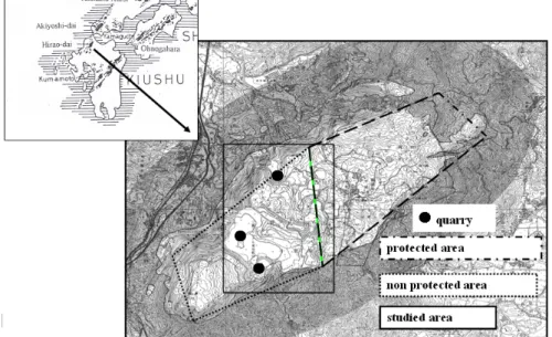
The study area was chosen on the Hirao-dai Karst, which is one of the most important karst regions in Japan. The small karst plateau is situated in Kokura Minami in Kitakyushu City, on Kyushu Island, Japan (Fig. 1). The area stretches 6.3 km from north to south and 2.7 km from east to west and has an altitude between 350 and 700 m.
Due to the physical properties of the pure white, recrystallized limestone, dating from the Paleozoic era, erosion, a number of characteristically rounded rock-pinnacles (karrenfeld), dry valleys, and smaller and larger dolines have formed on the planation surface. This most beautiful landscape is famous for evokative photos of flocks of grazing sheep. Karstic springs are issued on different altitudes of the plateau. Grass fields stretch out on this karst plateau, which is the secondary vegetation, and some forests have grown. To preserve the grassland and promote tourism the grass of the karst area is burnt in every February. Although approximately half of this large hydrographically solid karst plateau (14 km2) is designated a protected natural monument park (part of the Kitakyushu Quasi-National Park), there is a long history of exploitation of mineral raw materials on the remaining half of the plateau (Fig. 1) (Kinosita 1953; Tsuchida 1970; Urata 1993, 1999).
Fig. 1 Location map of study area (based on Urata 1999).
3. Method and materials
The selected area is close to the border and encompass both the protected and the non-protected fields. Valuable information was obtained from analysing topographic maps (1:25,000) from different years (1955, 1970, 1999, 2001) and from evaluating aerial photographs (1:10,000) and images.
Analysis was performed via a digitizing 3D surface mapping program. Drawing a parallel between different maps depicting changes of karstland-formations over the last five decades alterations could be determined. This investigation was expanded since field trips and collecting local data.
4. Results and discussion
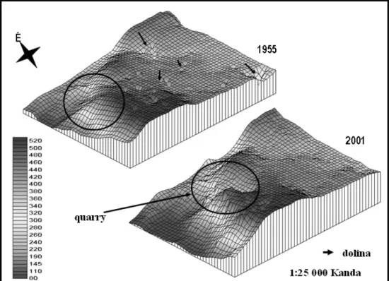
Comparing generated 3D surface models, changes to the surfaces close to the mines as well as in the larger surroundings are clearly noticeable from the time the quarries opened.
The relief models show alterations in many dolines on the north (around Kanda) of this karstic area, which was mapped in 1955. (Fig. 2) Since 1955 several companies have opened open lime quarries on the middle and SW parts of the plateau (e.g., Nihon Cement Corporation, Hokoku Cement, Mitsubishi Materials' and Sumitomo Osaka Cement's). Most of these cement companies have since discontinued mining, but the processed area has nevertheless been vastly expanded. The result of quarrying started that year is a rather conspicuous „landscape breach” (Fig. 2).
Dolines have collapsed and disappeared in the protected area, too. Gradual sinking and doline collapse are natural processes in karstland, but human action (e.g., by changing the water flow by quarrying) can induce and speed it up (Aley et al. 1972).
Surface runoff was modified up to 2001 (Fig. 3).
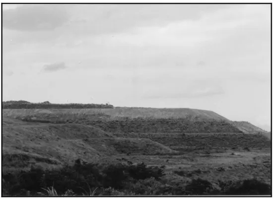
According to comparisons between the conditions in 1970 and 1999 on the south area (around Yukihasi) the situation is similar to results in the north: less dolines and pits (Fig. 4). However, another landscape modifying activity can be seen; in many cases the rubbish was disposed on existing dolines (Fig. 5) or in dry valleys above ground on the border of the protected field. Since the protected and non-protected areas form a solid karst system, the method of the recultivation is questionable.
Fig. 2 Model of surface changing on the north (around Kanda) of karstic area between 1955 and 2001.
Fig. 3 Model of relief runoff changing on the north (around Kanda) of karstic area between 1955 and 2001.
Fig. 4 Model of relief changing on the south (around Yukihasi) of karstic area between 1970 and 1999.
Fig. 5 Disposed rubbish on the karst area
Geomorphology and surface runoff are also significantly changed on these fields.
The inference that changes on the surface has resulted in changes in the underground water flow and morphology have not been proven.
5. Conclusion
The Hirao Karst plateau is a hydrographically uniform karst system. The natural processes of change might have been modified and intensified by the exposed exploitation of quarries. Runoff conditions and karstmorphology has not only altered the area of the limestone mines, but the protected area, too.
This research points to the possible implication of human activity as one of the factors that generates these changes in the karstland. When marking the boundaries of a nature protected areas, especially karstland, designation by law is not sufficient: changes in the surrounding relief may affect the protected area too. The study mentioned above raises important questions of karsland protection when determining nature conservation borders other countries, as well.
According to this research, it can be stated that a perfect resolution for the protection of special geomorphological values in this area is uncertain.
Acknowledgments
The author gratefully acknowledges Professors N. Hori of Tokyo Metropolitan University for his expert advice which made it possible to proceed with this research supported by Japan Society for the Promotion of Science.
References
Aley, T. 2000. Water and land-use problems in areas of conduit aquifers. In Speleogenesis- Evolution of karst aquifers Nat. Spel. Soc. Inc., ed A. B. Klimchouk et. al., 481- 484. Alabama.
Aley, T., and Aley, C. 1986. Effects of land management on cave and water resources, Dry Medicine Lodge Creek Basin, Bighorn Mountains, Wyoming. 6th National Cave Management Symposium Proceedings, 79-92.
Aley, T. J., Williams, J. H., and Massello, J. W. 1972. Groundwater contamination and sinkhole collapse induced by leaky impoundments in soluble rock terrain. Missouri Geological Survey and Water Resources, Engineering Geology Monographs 5: 32.
Bárány-Kevei I. 2001. Human Impact on Hungarian Karst terrains. Fifth Int. Conference on Geomorphology. Abstracts of Conference papers, Tokyo, Japan. 16.
Eberhard, S. M. 1995. Impact of a limestone quarry on aquatic cave fauna at Ida Bay in Tasmania.
Paper presented at 11th Conf., Australian Cave and Karst Management Association, Tasmania.
Gillieson, D. S. 1989. Effects of land use on karst areas in Australia. In Resource Management in Limestone Landscapes: International Perspectives. Dep. of Geogr. and Oceonogr., Univ. College, Australian Defence Force Academy,. eds. D. S. Gillieson and D. I. Smith, Canberra. 43-60.
Kinosita, K. 1953. Hirao-dai. Kokurashien Hirao-dai Karusuto 2, Kokurashi Shiyakusyo Chousaka, (In.: Kokura ed. Hirao-dai Karst vol. 2., Research report, Kokura, Japan) 1-32. *
Tsuchida, K. 1970. Dolinas of the Hirao-dai-Karst. Sekkaiseki 131: 12-17. *
Urata, K. 1993. Study of the relationship between karst landform and geological structure – North of Kitakyushu Hirao-dai. Japan Geographycal Society. 44: 176-177. *
Urata, K. 1999. Hirao-dai Karst drainage system (3). 25th Conf., Spel. Society of Japan, Akiyoshidai, Abstracts of Conference papers, Japan, 10-11. *
(*: in Japanese)