Quaternary Geology along the Katsuura-gawa river
East
Tokushima Prefecture,East Shikoku
Taikou MiTusio'* and Kimihiro Sasaki ' *
`゛Department of Natural E几mronme几tal Science, Faculty of Scie几ce Kochi Uaiiノersity, Kociii. 780-8520 JAPAN
Abstract: The writers surveyed along the Katsuura-gawa river. east Tokushima Prefecture, east Shikoku, and the Quaternary System was made clear such as f0110wS:The area is mainly com-posed of the Pleistocene deposits and Holocene Alluvial ones. The Pre-terrace deposits of the Early Pleistocene is the Sugezou Formation, and the Middle Pleistocene of the Higher Terrace deposits, H, is the Kushibuchi Formation. The Late Pleistocene is divided into two; the Middle Terrace deposits and the Lower Terrace ones. The former is composed of the fluvial Gyoji Formation, M, and the marine Tennoudani Formation, M'. The Lower Terrace deposits are also divided into two of the Nakayama Formation, LI, and the Nue Formation, LII. The Holocene sediments are also divided into two of the Alluvial Terrace deposits of the Katsuura Formation,
AI, and the Komatsujima Formation ,All, forming the wide Alluvial Plain. These strata are correlated with those of the other areas in Tokushima Prefecture, and paleo-environmetal changes around the Katsuura-gawa area are also discussed.
Kev word:Quaternary System Katsuura river Terrace Paleo-environment
Introduction
Mitusio, one of the writers, has been surveying the Quaternary System since 1966 in Shikoku Island (Mitusio etd。1966), and since then the Quaternary System in various areas is reported
(for example: Mitusio e£al, 1977; 1985 a: 1985b). According to these results, Mitusio and Furukawa (1988) reported the Quaternary strata in Shikoku. Again Mitusio and Kagami (1992) compiled the Quaternary System in Shikoku. Then the other areas including Kyushu, Honshu and Taiwan are rerported, and all these references are reffered to Mitusio and Ikeno (1998 c).
As for the Quaternary System in Tokushima Prefecture, east Shikoku Island, Nakagawa
(1969) first compiled the outline of it in Shikoku. Before it, Nakagawa e£al., (1964; 1965) reported the underground geology around the Tokushima Alluvial Plain, and their division of the Kushibuchi gravel bed, the Tanano gravel bed and the Nue Formation along the Katsuura-gawa river, was described. Also Terado (1966) reported the Quaternary terraces rather widely distributed in east Tokushima Prefecture. Suyari et al. (1987) reported the hydrogeologic map of Tokushima Prefecture, and they described some classification of the Quaternary strata. Then the writers reported the Quaternary System in Tokushima Prefecture such as f0110ws:
At the upper and middle stream areas along the Yoshino-gawa river, it was reported (Mitusio e£ ・・,1991; Mitusio and Shima, 1993). And the outline of the Quaternary System along the
46 高知大学学術研究報告 第48巻(1999年)ニ自=然科学
y ar旦a_
Fig. 1. Index map showing the study area alongフthe Katsuur良一gawa river, east Tokushima
Prefecture. 尚 ダ: ノ\ ・...・.・.・.・・・. ・.I ・・ ・
Square is the surveyed area. M, Matsuyama TA√TakamatsuダTO, Tokushima K, Kochi R.HI, Hiji river R. YO, Yoshino river R. NA, Nakagawa rivむrトR.NA, Monobe river R. NI, Niyodo
river R. SI, Shimanto river
whole area of the Yoshino-gawa
river was reported (Mitus呵and
Hash!moto,
1994). Next, the
Naka-gawa
river was surveyed (Mitusio and Kuribayashi, 1997). Then the Quaternary
System
along the middle stream area of the Akui-gawa
river声明reported (Mitusio and Ikeno, 1998).
And this time, the Quaternary
System
along the Katsuura-gawa
river, east Tokushima
Prefecture, east Shikoku is surveyed and reported (Fig. 1∧)∧‥ I… …
Outline
of Topography
and Geology
This area locates to the estern part of Tokusね面a Prefecture of east Shikoku。and it belongs to the Middle Shikoku according to the Quater印町division of Shikoku Island by Mitusio and
Kagami (1992)。 し………エノ土 ,…………JI
And the Katsuura-gawa river system here is as follows (Fig. 2 ):The Katsuリra-gawa river,
starting from the high mountainous area of Mt. Takam・aru (!,438m) and Mt. Sounzan
(1,495m), those locate nearly at the central part ∧of the S叫koku Mountains, flows almost linearly from the southwest to the northeast direction, and it directly pours into the Kii Straits,
that divides Shikoku and the Kii Peninsula, Honshu. ‥‥‥‥ = づ 犬
The river length is about 45km, and the drainage area along this river is considerably wide, and the longitudinal profile of this river as well as the terrace plains is shown in Fig. 2 . Along this river, six flat terrace plains and:one Alluvial………pla・inare found, and the almost Quaternary strata forming these terraces plains are newly defined.
l 0 47 Altitude(m) 500 400 300 200 0 0 40 30 2ひ
Distance froi t!ie river nouth (km)
Fig. 2. Longitudinal profile of each Terrace Plain and the river section along the Katsuura-gawa river, east Tokushima Prefecture.
S,Sugezou Plain=pre-Terrace K, Kushibuchi Plain=Higher Terrace G, Gyoji Plain =
Middle Terrace Na, Nakayama Plain=Lower Terrace, LI Nu, Nue Plain = Lower Terrace, LII
m. dam, Masaki dam S. river, Sakamoto tributary of the Katsuura-gawa river
Middle to North Chichibu Terrain of Paleozoic to Cretaceous ages. 0n these basement rocks, the
Quaternary strata cover them unconformably, and the writers defined mostly the new
Quaternary strata names, and they are as follows in ascending order: The Early Pleistocene Pre-terrace deposits of the Sugezou Formation, forms some flat plain of about 490 m asl. The
Middle Pleistocene of the Kushibuchi Formation forms the Higher Terrace, H. The Late
Pleistocene forms two terraces of the Middle Teraces of M and M’ and the Lower Terraces of LI
and LII. M is the fluvial Gyoji Formation, while M’ is the marine or beach Tennoudani
Formation. LI is the Nakayama Formation, and LII is the Nue Formation. The Holocene strata are also divided into two of AI forming the Alluvial Terrace of the Katsuura Formation, and All of the Alluvial Komatsujima Formation forming the wide Alluvial plain.
Description of the Quaternary
System
TheQuaternary
System
of the Early to Late Pleistocene and Holocene along the Katsuura
gawa
river is described in ascending order.
48
→
高知大学学術研究報告 第48巻(1999年)六自=然科学 ㎜KPeS11NP 畷闇G P FTFTごIAP士
㎜IくF F;呂ll;l卜■J'B' 闇闇GF円丁∃y\ F" sao 11・Oi し _ _ 一 一 一 一 4 − JFig. 3A. Geologic (lower) and topographic (upper・)㎡aps of the down-stream
area along the
Katsuura-gawa
river. …………]………レ(レ 犬 レ
KP, Kushibuchi Plain=Higher
Terrace NP, Nakayama
Plain〒Lower
Terrace, μ GP,
Gyoji
KRトKushibuchi Formation = Middle Pleistocene
χF, Alluvial Formation=Holocene.
Plain=Middle
Terrace AP,
Alluvial Plain KF
NF, Nakayama
Formation = Late Pleistocene AF,
And all the geologic and topographic maps are shown i11 Fjg・3 A∼Fig. 3 F, and geologic cross sections are shown in Fig. 4 A∼Fig. 4 D. The co恒男姐r sections including their localities are shown in Fig. 5 and Fig. 6 . Also paleo-environmental changes are shown in Fig. 7.
1 . Early Pleistocene Sugezou Formation=Pre-Terrace Depo付知
The Early Pleistocene in this area is named and reported as the Sugezou Formation.
Author: Sasaki, K. and Mitusio, T. (1998) △ =
Name:
Sugezou Formation
(newly defined) …………j
Type locality: Sugezou, Kamikatsu
Town, Katsuura-Gun。Tokushiama
Prefecture,loc. 22
Thickness: 5 m
■■ ■■■■■ ■■ ■■■ ■ ぐ
Distribution height: 490m ∇ ‥‥十 ・.,. ,
Relative height from the river bottom:130m = ‥ し ,
49
‘ `1.
2゛
よ
ー≒ノ
Fig. 3B. Geologic (lower) and topographic (upper) maps of the middle stream area.
KP, Kushibuchi Plain= Higher Terrace GP,
Gyoji Plain=Middle
Terrace NaP,
Nakayama
Plain= Lower Terrace, LI NP, Nue Plain=Lower
Terrace, LII AP, Alluvial Plain
KF, Kushibuchi Forination=Middle
Pleistocene GF, Gyoji Formation=Late
Pleistocene
NaF, Nakayama
Formation=Late
Pleistocene NF, Nue Forination=Late Pleistocene
AF, Alluvial Formation=Holocene.
Topographical plain: Sugezou Pre-Terrace Plain=pre-H
Distribution: This Formation distributes only in a narrow area near Sugezou, Kamikatsu Town, at the upper-stream area of the Akui-gawa river, and this attains five meters thick. This ditributes at about 490 m asl., and the relative height from the river bottom is about 130m. And this is composed mainly of the gravels of sandstones. The maximum diameter of the gravels is about 20cm, and the predominant one is about five centimeters. The roundness of the gravels is subangular to subrounded ones. The colour of the gravels is white, but they are fresh ones, with the grey silt matrix. The consolidation of the Formation is very hard。
This Formation overlies the basement rocks unconformably. And this distributes more
higher part than the Kushibuchi Formation of the Higher Terrace Deposits which is descrived below. Then this Fomation may be considered as the Early Pleistocene age, although some doubt
50 高知大学学術研究報告 第48巻 )自然科学 ̄
that this may be of the Paleo-talus deposits, exist斗 士 ∧ …………
2. Middle Pleistocene \ ・.
The Middle Pleistocene in this surveyed area is named a:s the Higher Terrace Deposits of the Kushibuchi Formation by Nakagawa (1964). And here the writersレnewly redefined (Tab. 1).
Author: Nakagawa, C. (1964); revised by Sasaki, K. and Mitusio, T. (1998)
Name: Kushibuchi Formation グ ニ
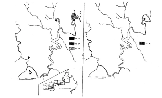
Type locality: Kushibuchi, Komatsuiima City, Tokushima::Prefecture, loc. 26
Thickness: 3-1m : \=l………J いダ…………く……… ニ ‥
\│
土
l ( ・ )
Fig. 3C. Topographic map
of the Sakamoto-gawa
tributaryぺofthe upper stream area of the
Katsuura-gawa
river. ノ ソ
KP, Kushibuchi Plain=Higher
Terrace GP,
Gyoji:Plain=∧Middle T・errace NP, Nue Plain =
Lower Terrace, LII Inthis avea, no strata are found, but only topographical plains exist.
Distribution height: 600-80m コ ∧
Relative height from the river bottom: 100-70m ………:………1: ■■■■■■■ ■■ ■
Topographical plain: Kushibuchi Terrace Plain=Higher Terrace, H
Distribution: This Formation distributes limitedly at three areas of Chouji (loc. 4 ) of Iidani
Town, Tanano (loc. 17) of Katuura Town, and Kushibuchi of Komatsujima City. The
Kushibuchi Terrace Plain of the Higher Terrace, H, is found f衣)m Yaeji, Kamikatsu Town of the upper-stream area of the Akui-gawa river to Chouii, Iidani Toられof the mid-stream one, how-ever, the preservation of the Plain is bad. And itd鍋物ibut面如otted!y because of severe weath-ering. ◇ ∧ 丿 ノ ∧●
ne to three meters thick, and the distribution
And
the relative height from
the present river
The thickness of the Formation is about one to height is various such as about 600-80m asl.
51
bottom is about 100-70m asl.
The kinds of the gravels are conglomerates, sandstones and chert. The predominant gravels of conglomerates is about 50cm at its diameter at Chouii (loc. 4 ) and Tanano (loc. 17),and the maximum diameter of those is over one meter.
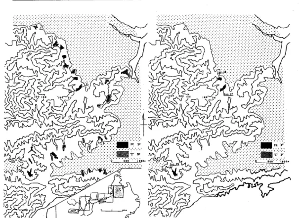
Fig. 3D. Geologic (right) and topographic (left) maps of the upper-stream area. KP, Kushibuchi Plain=Higher Terrace GP, Gyoji Plain = Middle Terrace NP, Nue Plain = Lower Terrace, LII GF, Gyoji Formation=Late Pleistocene
The sorting of the Formation is bad. The roundness of the gravel!5 is 0.6 0f sandstones, and 0.4 of chert. At Chouji (loc. 4 ), many gravels of sandstones are severely weathered to the core of them, and they are so-called corroded gravels。
0nthe contrary, the gravel bed at the hill-top of Kushibuchi (loc. 26), where the paleo-Katsuura-gawa river once flew and showed the paleo-Katsuura-gawa river route, is composed of chert gravels without the gravels of conglomerates that were found at the localities of Chouji (loc. 4 ) and Tanano doc. 17). The chert gravels with very high sphericity and roundness are found abundantly, however, the boulder gravels of conglomerates and sandstones found at both Choji and Tanano, do not distributed. The maximum diameter of the gravels is over one meter and the predomonant ones are about 25cm. And the gravels of conglomerates and sandstones are semi-corroded ones. They are not so much weathered as those at both Choji and Tanano. The matrix of this Formation is of yelowish brown, while that at both Choii and Tanano is of reddish brown。
Inaddition, the imbrication of over 50 samples of the gravels were measured at loc. 26, and the paleo-current direction of the supplyment of the gravels shows N 30°E ,and this direction shows that the Paleo-Katsuura-gawa river once flew to the direction of eastward when the
52 高知大学学術研究報告 第48巻(1999年)二自然科学
Kushibuchi Fomation was deposited. …………く………j=… … =‥‥‥=‥‥‥:
The longitudinal profile of this Formation much resemblefけo that of the Present Katsuura
gawa river. ▽ □SP■KP回l囲N? ・ ・G IP \:'::::\-^ ^ [ニコsF阿l回NF ・ ・G F FTコA. F"
Fig. 3E. Geologic (upper) and topographic (lower) mapりプofthe uppermost stream area.
SP, Sugezou PlainニPre-Terrace KP,
Kushibuchi Plain = Higher Terrace NP,
Nue
Plain =
Lower
Terrace, LII GP,
Gyoji Plain = Middle Te紅如eニ:AP, Alluvial Plain SF,
Sugezou
Formation = Early Pleistocene NF, Nue Formation = L尽tePleistocene GF, Gyoji Formation =
Middle Pleistocene AF, Alluvial Formation = Holocene. \
This Formation
is thought to be of the Higher Terrace Deposits of the Middle Pleistocene
age, considering the charactristicsof the gravels and topo如面hid・features.
仁一
Fig. 3P. Geologic (right) and topographic (left)maps near the coastal area.
KP, Kushibuchi Plain = Higher Terrace TP, Tennoudani Plain=marine
Middle Terrace
KF, Kushibuchi Formation = Middle Pleistocene,H TF, marine Tennoudani
Formation = Late
Pleistocene,M'
3. Late Pleistocene
The Late Pleistocene in this surveyed area is mainly divided into two terraces deposits that are the Middle and Lower ones.
And also the former one 1S separated into two strata of the Gyoii Formation, M and the
Tennoudani Formation, M'(Tab. 1).
The Lower Terrace deposits are also divided into two of the Nakayama Formation, LL and the Nue Formation, LII.
3 −1 Middle Terrace Deposits
The
Middle Terrace Deposits here are composed
of two:the Gyoji Formation (M)
and the
Tennoudani
Formation
(M').
3 −1 -A
Middle Terrace Deposit, M
The Middle Terrace Deposits are the Gyoji Formation, M and the Tennoudani Formaton, M’
Author: Sasaki, K. and Mitusio, T.(1998)
Name:
Gyoji Formation
(newly defined)
54 50 0 高知大学学術研究報告 第48巻(1999年)ダ自然科学 ・ 3 0 ○
Fig. 4A. Geologiむcross sections at the down-strea血謡ea](left) a・nd along・the coastal area (right).
a−a'ニshown in Fig. 3A. b ―b'=shown in Fig. 3FレKFレKushibuchi Formation NF, Nue
Formation TF, marine Tennoudani Formati:on ∧ ノ …………ト
5 0
0
謳贋蔚G一回回lヽJr.;
Fig. 4B. Geologic cross section at the middle stream area.……:………… c―c' = shown in Fig. 3B, GF, Gyoji Formation NF, Nue Formation
Type locality: Gyoji, Katsuura Town, Katsuura-gun, Tokushiama Prefecture, loC.7
Thickness: 3 −1 m ノ.…… レ ∧
Distribution height: 560-40m \ ○ し ■■■ ■■■■ く ..丿.
Relative height from the river bottom: 60-30m △..,……宍…… ……
Topographical plain: Gyoji Terrace Plain = Middle Terra叩Plain, M
Distribution: This Formation distributes widely along the midうtreamto down-stream area
of the Katsuura-gawa river. ………I.\くJ………=
This is composed mainly of gravels. The gravelsレare sorted, and they are pebbles of which the diameters are about four to one cm。The roundness of the gravels increases gradually as the gravels are transported along the river from the upper一叶n逼れ]area to the ・down-stream one, where the roundness at the upper-stream area is angular,:and itレ]ofthe down-stream area is the subrounded gravels. The variety of the gravels is mainly of:sandstones, mudstones and chert, and these are semi-corroded ones. The matrix is yellowish brown coloured silty sand.
55
MI, and this plain is well conserved. The longitudinal profile of this Formation much resembles to that of the Present Katsuura-gawa river.
3 −1 -B Middle Terrace Deposits, M’
The Middle Terrace Deposits of the marine one is the Tennoudani
Formation.
Author: Sasaki, K. and Mitusio, T. (1998)
Name:Tennoudani
Formation
(newly defined)
Type locality: west of Tano, Komatsujima
City, Tokushima
Prefecture, loc. 27
1 0 0
5 0
0
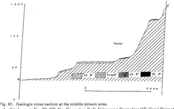
Fig. 4C. Geologic cross section at the middle stream area.
d一d'=Shown
in Fig. 3B. NF, Nue Formation NaF, Nakayama
Formation GF, Gyoji Formation
KF, Kushibuchi Formation
Thickness: 12m
Distribution height: 40-30m
Topographical plain: Tennoudani PlainニMiddle Terrace, M’
Distribution: The type locality is at the Yasaka Shirine of Tennoudani, west of Tano of loc. 27. And this Formation exists at the other area of Shirasuna, Komatsujima City. However, the Tennoudani Plain of the Mddle Terrace Plain, M’ with the height of 40 to 30masl, distributes continuously on the hills of west Tano and the north-south trend of Kushibuchi.
This Formation attains about 12m, and the distribution height is about 40 to 30masl. This is composed of gravels of chert and metamorphic rocks, and the gravels of sandstones and
mudstones are never found that are included in the Terrace Deposits along the Katsuura-gawa river.
The chert gravels are generally white. The roundness of the gravels is low, and it is angular to sub-angular. The maximum diameter of chert is over one meter, and the predominant one is
56
高知大学学術研究報告=第48巻(1999年)
about five to three cm. ‥‥‥ ‥‥‥ ‥‥‥‥‥‥
On the contrary, the roundness of the gravelsレof the metam面皿icレrocks is 0.7, and this is very well-rounded gravels. The many gravels are flat, and the maxumum dimeter of the gravels is over 30 cm, and the predominant one is about 10 cm. The gravels d the metamorphic rocks are very severely weathered, and are rich in th6ねr foliation. The matrix of the Formation is
reddish brown coloured silty material. \
The longitudinal profile of this Formation is not shown here, because this does not follow along the Katsuura-gawa river but along the route 55√and the sediments may be of beach one and the production of the Paleo-Tosa Bay transgression defined by Mitusio (1985b).
1 5 0
100 5・ 5・ ○
Fig, 4D. Geologic cross sections at the upper and uppermost area of the Katsuura-gawa river
e−e'=shownin Fig. 3D. f―f =shown in Fig. 3E. GF, Gyoji Formation
3 −2 Lower Terrace Deposits, LI and LII ∧ .・・・.・. ・.・. ・・・ .・
The Lower
Terrace Deposits in the surveyed area is……divided
into
two: theNakayama
Formation,
LI and the Nue Formation,
LII. \
3 −2 -A Nakayama FOI゛mation.LI (newly defined)九才…………上上・1・...……
Author: Sasaki, K. and Mitusio, T.(1998) :
Name: Nakayama Formation / > 白 ……… …
Type locality: Tanano, Katsuura Town, Katsuura-gun,ごlokushima Prefecture, loc. 16 Thickness: 2 m 犬 ‥‥‥‥‥
Distribution height: 60-55m 二 十\ ニ ニ
Relative height from the river bottom: 30-25血ニ\ …………ノ:………= 犬
Topographical p!ain:Nakayama Terrace Plain = LlOWer Terrace Plain, LI
Distribution: The type locality of this Formation exsists at loc. 160f Tanano, and this is about two me七己rsthickトThis Formation is composed of the gravels, and the kinds of them are
57
sandstones, cherts, consflomerates and mudstones.
The maximum
diameter of the gravels is
about 40 cm, and the predominant
one is about six to five centimeters. The roundness of the
gravels is about 0.7 to 0.5, and it is rounded to subrounded gravels.
A Kuso Mt
Fig. 5. Locality numbers of the outcrops shown in Fig. 6.
a一f,see geologic maps of Fig. 3A∼Fig。3F.
The gravels are more flater than those of the other terrace deposits. This Formation shows upward-coarsening, and the imbrication develops well・
Some sandstones gravels are found to form the red weathered core, as those contained in the Gyoii Formation. And also the cherts gravels in this Formation are not so much weathered. The matrix is yellowish brown coloured silty materials, and consolidation of this Formation is rather hard.
This Formation forms the Nakayama Plain and distributes locally, but the reservation of the Terrace Plain is very good along the down-stream area of the Katsuura-gawa river. This is about 60 to 50masl, and the relative height from the Present river bottom is about 30m to 25m. The longitudinal profile of this Formation is limitted, but this much resembles also to that
of the Nue Plain. But this Plain can be distinguished from the Nue Formation by the distinct differences of height and also gravels contents between these two Formations.
3-2-B
Nue Formation,
LII
Author:
Nakagawa,
C. (1964); redefined by Sasaki, K. and Mitusio, T. (1998)
Name:
Nue Formation
Type locality: Hisakuni, Katsuura Town, Katsuura-erun, Tokushima
Prefecture,loc. 12
Thickness:
6 −1 m
Distribution height: 450-20m
Relative height from the river bottom : 20-15m
58 2 1 0 − (m3
匹
m
皿
K 高知大学学術研究報告 第48巻(1999年)∇自然科学品閲
E28口口陥 H 27一ロ^≫^^'^:■. じDistribution: The type locality of this Formation exists at loc. 12 of Hisakuni, Katsuura Town, and the thickness is about two meters. This Formation iな mainly composed of gravels, and the total thickness is about six to one meters th1むk. The gravel variety is sandstones and cherts with the longer diameter of about 10 cn!. The maximu皿diameter of the gravels is about 40 cm, and the predominant one is about 10 cm with some gravels of over 20 cm.
F
鮨固図
萬削慰嗣副翔
ふ回翔
y回胴
7回駿限
2回回国
NaF-阻闘順順顛回国
菖四国
25圖開削昭一
si脱同剛
謁問
E亜閥阿
ら10畷洽同にに吻
9隔
魚陽筒
5照
応白目I
n翻間
Gravel Bed Surface Bed Basement F よ1胴関国
八F
18
U
24図剛
肪削附麟問
品回図
鼠固躍醸搦M
Fig. 6. Geologic colamunar sections ‘ ……: 六大 ニ (’
KF, Kushibuchi Formation=Higher Terrace deposits,・=j・H.・..・of・Middle Pleistoむene SF, Sugezou
Formation=Pre-Terrace deposits of Early P!eistocene AF, Kムtsuura Formation=Alluvial
Terrace deposits, AI of Early Holocene GF, Gyoji Formation〒Middle Terrace deposits, M of
Late Pleistocene TF, marine Tennoudani Formation〒Middle TeΓΓace deposits, M' of Late
Pleistocene NaF, Nakayama Formation = Lower Terrace………deposits,LI of Late Pleistocene NF, Nue Formation=Lower Terrace deposits, LII of Late Pleistocene
59
The gravels are commonly well rounded, and the roundness of cherts gravels is 0.9 and the sphericity is 0.6.
Inaddition, at loc. 8 of Gyoii, Katsuura Town, the outcrop is found as 6.3 m thick, and the
very well rounded gravels of sandstones and mudstones are abundantly found at the lower
horizon of about 2.5 m thick. However at the upper horizon of about 3.8 m thick, the subangular
chert gravels become abundant but the roundness becomes lesser. Also the numbers of the
boulders decrease upwards, and over half part of the boulders is occupied by cherts gravels with
over the diameters of 30cm and maximum over 50 cm.
The all gravels of this Formation are not weathered and are fresh comparing with those in the other Formations eχisting along this Katsuura-gawa river・
The matrix is dark brownish, and the consolidation of this Formation is generally higher and harder.
The Nue Plain develolps from Asahi, Kamikatsu Town of the upper stream area to Choji,
Iidani Town of the middle stream area along the Katsuura-gawa river, and especially this Plain extends continuously from Hisakuni, Kamikatsu Town to Nue, Komatsujima City. The reserva-tion of this Plain is best among all the Terrace Plains in this surveyed field・
The Plain lies between about 450m to 20masl, and the relative height from the Present river bottom is about 20m t0 15m.
The longitudinal profile of this Formation extends along the down stream area of the
Katsuura-gawa river. And this much resembles also to those of the Gyoji Plain and of the Present Katsuura-gawa river.
4 . Holocene Deposits, A
Inthis area, the Holocene Deposits are divided into two: The lower one is newly defined as
the Katsuura Formation forming the Alluvial Terrace Plain, AI, and the upper one is the
Alluvial Formation composing the wide Alluvial Plain, All of the Komatsujima Plain.
4-1. The Katsuura Formation (newly defined)
Author: Sasaki, K. and Mitusio, T.(1998) Name: Katsuura Formation
Type locality: Tanano, Katsuura Town, Katsuura-gun, Tokushiama Prefecture, loc. 18 Thickness: 2 m
Distribution height: 40m>
Relative height from the river bottom: 10m>
Topographical plain: Katsuura Alluvial Terrace Plain=Holocene Terrace Plain, AI
Distribution: The outcrops of this Formation are found at only two localities of loc. 18 and loci (Fig. 6). The type locality, loc. 18 of this Formation exists at Tanano, Katsuura Town. This has three m thick, and is composed of the gravels of sandstones and mudstone both with
0.6 of the roundness and with the chert gravels of roundness 0.4. The maximum diameter of the gravels is about 40 cm, and the predominant one is about five cm. At loc. 1 of Okino, Tokushima City, this is two m thick, and the kinds of the gravels are mainly sandstones, mudstones and cherts with the high degree of both the roundness and sphericity.
60 高知大学学術研究報告 第48巻ト(1999年 自然科学
- The gravels are not weathered at all, and the matrix is the greyish clayey materials. This Formation forms the Alluvial Terrace AI of the Kat面面a Plain, and this Plain is about 40 m asl, and the relative height from the Present river b:ottom is less than about 10m.
4 - 2 . Komatsujima Formation, All コ ト , 士
Author: Nakagawa, C. and Suyari, K. (1965); redefined by Sasaki。K. and Mitusio, T.(1998)
Name: Komatsujima Formation ………lj= 1…………j犬………:
Type locality: underground of Komatsujima City, TokushiamaトPrefecture
Thickness: about 40 m ………:ノニ:………;‥‥‥‥‥‥
Distribution height: 400-10m> ニレニ尚………=‥‥‥‥
Relative height from the river bottom: 10m> 几 ・・
Topographical plain: Komatsuiima Alluvial Plain〒Holocene Plain, All
Distribution: The outcrops of this Formation are not found大尽t the surface area on the
Alluvial Plain. However, Nakagawa e£ 「。(1965) repo社司\鋤e六寸ructure beneath the Plain.
According to them, the Komatsujima Formation is divided into two of the Upper Member and
the Lower Member. The Upper Member is mainly composed of sand and gravel to silty sand
with about 13.5m thick. The Lower Member is mainly:co血posed of drak gray clay and silt with about 30m thick, and the volcanic ash of Onii or Akahoya√is intercalated at the horizon of about 17 t0 18m. Also the upward coarsening of the finer particles to coarser ones is found in
the Lower Member. /
Correlation of the Quaternary System
The Above-mentioned Quaternary System is to be correlated with those where they surveyed in the other areas especially in Tokushima Prefecture. This is°such as follows which are shown in the correlation table of the Quaternary System (Tab.°::1)ソ☆‥: ニ
the Eearly Pleistocene in this field isトto be correlated with the
)ng the Naka-gawariver……and the Nanii Formation along the
The Sugezou Formation
of the Eearly
Kuronda-touge
Formation
along the N
Akui-gawa river. Also this Formation is con・elated with thりDochu Group along the
Yoshino-gawa river. 六万 ノ……= ・.・.・・ ・・ .・.
The Kushibuchi Formation forming the Higher Terrace of the Middle Pleistocene in this area
is correlatable with the Kuronda Formation along theしNaka-gawa river, and the Ohnoii
Formation along the Akui-gawa river. This is also correlatable with the Ideguchi Formation at the northern coast and the Oiima Formation at th6レsouthern coast of both the down stream area of the Yoshino-gawa river. This Formation is also correlatりd 軸th the Nakanishi Formation at the middle stream area and with the Yoshino Formatioれat the upper stream area, both of the
Yoshino-gawa river. ‥‥‥‥‥= し / □
The Gyoji Formation of the Middle Terrace of the La:te∇Pleistocene in this area is correlated
with the Kawashima Formation along the Naka-gawa river aれdレthe Nihongi Formation along
the Akui-gawa river. And this is also correlated 耐th∇two For血ations of Kirido and Baba both at the northern coast, and the Oiimaeki Formation at the southern coast of both the down stream area, and the Handa Formation at the 血iddle stream area, and the Ohse Formation at
61
Tab. 1. Correlation table of the Quaternary System in Tokushima Prefecture, east Shikoku.
Area Age Katsuura- gawa River Akui-gawa River Naka-gawa River
Kuwano
-gawa
River
Yoshino-gawa River
ご回‰に竺二言
Holocene AUuv, F Katsuura F AUuv. F AUuv. FKawagiri F Alluv.F
Alluvial Formation
ヒヽ 自 白 司 (5
Late
Nue F Nakayama F Tennoudani F* Gyoji F Ohkubo F Hanotsuji F Takase F Nihongi F Wamuta F Kawashima F Arata F Dodobaru FIwakuraF
K B
F F
Toubun F Ojima-eki F Hiruma F Higashi-kawaharaF Handa F Uenaro F Ohse F Mid- die Kushibuchi FOhnojiF
Kuronta F HTDIdeguchi
F
Ojima F NakanishiF Yoshino FEar- 1y
SugezouF Nandani F
Kuronta- toee F
D Iguchi-C tanigawaF G Ohtani F D Takase-C tanigawaF G Nakaue F PlioceneMoriyama
F
F, Formation Alluv. Ter., Alluvial Tel‘race HTD, Higher Terrace Deposits DCG, Dochu Group
KF, Kirido Formation
BF, Baba Formation Up.
-st・,
upper stream a.,area S., South
* includingbeach grarsels and equivalent of the Gyoji Formation
the upper stream area of all the Yoshino-gawa river・
The Nakayama Formation of the Lower Terrace LI of the Late Pleistocene in this area is distributed limitedly, and this is only correlated with the Hanotsuii Formation along the Akui-gawa river.
The Nue Formation of the Lower Terrace LII of the Late Pleistocene in this area is widely distributed, and this is correlated with the Wamuda Formation along the Naka-gawa river and
the Ohkubo Formation of the Akui-gawa river. This Formtion is also correlated with the
Iwakura Formation at the northern coast and the Toubun Formation at the southern coast
along the down stream area of the Yoshino-gawa river. Also this is correlatable with the Hiruma Formation at the middle stream area and the Kaminaro Formation at the upper stream
area along the Yoshino-gawa river.
The Katsuura Formation of the Alluvial Terrace AI of the Holocene in this area is correlated with the Kawagiri Formation along the Akui-gawa river, but there are no strata in the other areas.
62
高知大学学術研究報告 第48巻(1999年)自然科学
Alluvial Formations
forming
the Alluvial Plains. And
a11:these Alluvial strata in Shikoku
District are summarized
by Ogura, Mitusio and Yoshida (!989) and Mitusio (1998).
Paieo-environmental River Route Change of〕theKatsuura-gawa
river
According to these results mentioned
above, the::paleo-e・vironmentalchanges around
Katsuura-gawa
river is considered・ ‥‥‥‥‥‥ ‥‥‥
the
These are shown in Fig. 7. As it is clear from Fig. 7¬1, the Paleo-Katsuura-gawa river was once flowing to northward as the Present Katsuura-gawa r沁昨レis flowing. The evidences are as follows: Observing the maximum diameter of the gravels, the Kushibuchi Formation of HT has over one meter, while the Gyoji Formation of MI 叫衣 lessトtねan 30 cm with the subangular
ト ト し「ト :トダ ㎜■4 フ ゚ l … … = | ト
ルダ
-- ・ − -一 -一 ■ ■ ㎜言夢
|j………
ユノ
妄言汗ダ
Nニノ
Fig. 7. Changes of river route of the Katsuura-gawa
river.
T, Tennoudani
N, Nagashira
K, Kushibuchi
Ne, Nue
t↓
t6 T・anano
1)At the age of the Formations
of Sugezou (粉々-Ter砲如) and Kushibuchi (Higher Terrace
deposits),Early to Middle Pleistocene. ……I j ダ ,ノ
2)At the age of the Formations
of Gyoii and Tennoudani (Middle Terrace deposits of MI and
M"), Late Pleistocene.= eastwards flowing of the Paleo-Katsuura・gawa
river,Paleo-Tosa Bay
Transgression = Shimosueyoshi
Transgression 尚 ………∧白 j °
3)
At the age of the Formations
of Nakayama:(LI)ニand N臨(LID
(Lower Terrace deposits),
Late Pleistocene.= northward flowing of the Present一片atsuura-gawariver.
4)
At the age of the Tennoudani
Formation
(marine
Mユiddle Terrace deposits),Late
Pleistocene.= Paleo-Tosa Bay Transgression g Shimosueyoshi
Transgression, nealy equal age
63
gravels. Then as the geologic time has passed, the transportation ability of the Paleo-Katsuura-gawa river became lesser, and the background supplying the sediments was rather nearer。
Next, the Paleo-Katsuura-gawa river has changed the river route to eastward, as it is shown in Fig.7-2 and Fig. 7-4. This is the time when the sea level was high as about 40∼20m asl, that is defined as the Paleo-Tosa Bay Transgression by Mitusio (1985b). This transgression is also called as the Shimosueyoshi Transgression of about 140,000 ybp in Kanto District. The reason of higher sea level than the Present one is as follows: The gravels of the Tennoudani Formation with very rounded ones of metamorphic rocks except the subangular chert gravels is thought to be of beach sediments. And the fluvial gravels on the hilltop of loc. 26 (Kushibuchi), differs in their composition from those at loc. 4 (Nagashiro) and loc. 17(Tanano). Also the degree of weathering of the gravels differs, such as the corroded gravels at loc. 26 versus semi-corroded ones at loc. 4 and loc. 17。
Then at the age of forming the Lower Terraces of the Formations of Nakayama and Nue, the Katsuura-gawa river changed to the Present river route, as it is shown in Fig. 7-3.
Concluding Remarks
The writers surveyed the Quaternary Geology along the Katsuura-gawa river of east
Tokushima Prefecture. And the results are summarized as f0110ws:
1)The Quaternary Geology along the Katsuura-gawa river is divided into seven Formations and most of them are newly defined as follows: The Early Pleistocene is the Pre-terrace strata. The Middle Pleistocene is the Higher Terrace deposits and the Late Pleistocene is two 6f the Middle Terrace deposits M and M’ and the Lower Terrace deposits LI and LII. The Pre-terrace strata are the SugezouFormation, and the Higher Terrace deposits H is the Kushibuchi Formation. The Middle Terrace deposits and marine Middle Terrace deposits are
the Gyoii Formtion, M and the Tennoudani Formation, M', respectively. And the Lower
Terrace deposits are also divided into two deposits of the Tanano Formation, LI and the Nue Formation, LII. The Holocene sediments are divided into two of the Alluvial Terrace deposits
AI of the Katsuura Formation and the wide Alluvial Plain All of the Komatsujima
Formation.
2)These atrata are correlated with those in the other areas of mainly Tokushima Prefecture. 3)The paleo-environmental changes of the ancient river route of the Katsuura-gawa river is disscussed, such as the direction of it was changed from northward to eastward, then to northward as the Present Katsuura-gawa river flows・
The Quaternary geology in the other areas is to be reported on the other chance.
Acknowledgement
The writers would like to express their sincere thanks to Messors Kuribayasi, T., Ikeno, T. and Kanzaki, T. of the Department of Natural Environmental Science, Kochi University and Master Ueki, G. of the Department of Geography, Tokyo Metropolitan University, for their useful advices. And special thanks are also due to the members of the Research Society of Human and
64 高知大学学術研究報告 第48巻(1999牟)自然科学
Environmental
Progression (RSHELP),
for their・kind helps
Reference Cited
Mitusio, T. and Kattou, J.:Quaternary System in the north垢臨tern part of Kochi City. Res. Repヽ Kochi Univ.,21; 7-13(1966).** ‥‥ ‥‥ト ………
Mitusio, T. and Furukawa, H.・.Hvdroseoloがc Map 6/ Kagau』&I)refecture. 1 : 150,000. Ministry of Agric. Forest. and Fisheries(1977).* し ‥‥‥:……… …=j ト… …ダ ………
Mitusio, T。Shimizu, K. and Wada, M.:H%idrogeoloeic……raap(がKoch-i=Prefecture, 1:150,000. Ministry of Agri。 Forest. and Fisheries (1985a).* \ ∧………/= し ∇
Mitusio, T.: Marine geology of Tosa bay, Shikoku, Japan, part 2, Marine geology of very shallow portions.Res. Rep,Kochi U几辿・, 34; 61-72 (1985b)ソ フ
Mitusio, T. and Furukawa, H.:Quaternary strata in Shikoku District. Mem.Geol,Soc., 30; 145- 154(1988).** \ ∧1 \
Mitusio, T. and Kagami, H.: Quaternary System in……Shikoku 玖eぼ16n・Quat. Res., 31(5); 297-311 (1992).** ニ=…………レ…………:……
Mitusio, T. and Shima, S.:Quaternary System along・the upper andニmiddle stream areas of the Yoshino River, Shikoku. R S. Rep. Kochi Uniu.,41(6)け一加レ(1993)ゾ**
Mitusio, T. and Hashimoto, K.:Outline of the QuatφΓnary System along the whole Yoshino river, Shikoku. Res. Rep. Kocfii Uniu.,43-, 115-122(1994).** ノ ‥‥‥‥1
Mitusio, T.: Environmental change in the Kacho Plain, Koやhi Prefectare,Stud-y on the characters of几atural disaters and preventive poteatialitics□irt KbcJii Prefecture. Kocki Uriii).; 21-39 (1996a).** =尚ト……:………:\y‥‥‥ ト
Mitusio, T. and Kuribayashi, T・:Quaternary System十along the whole Nakagawa river, Tokushima Prefecture. Res. 石印. Kochiび心し46;ト65-78(1996b)ゾ**
Mitusio, T.: Environmental change near Tosa bay inくQuaternary age.1998'sOpea Seminer(7fFac. Sci. KocM Un.iuぷ39-58 (1998a).* ト \ト 万 \
Mitusio, T.:Environmental Changes of Kochi Prefecture in Holocene Epoch-Holocene Strata in Kochi Prefecture. Res. Rep. Koch,i Uniu., ≪; 33-48 (1998b).** J
Mitusio, T. and Ikeno, T.:Quaternary System along the middle stream area of the Akui river, east Tokushima Prefecture. Res.Rep. Kocfii Uaiu.iり;28-32 (1998c).**
Ogura, M., Mitusio, T. and Yoshida, T.:Soft:bed inトShikokuくDis:trict.即読λ皿.戸品. Soil E4g・ Shikoku Branc/i,; 62-83 (1989).* ……し…………レ I=・・ ・ ・・
Ueki, T・, and Mitusio, T,: Uplift history the As an Mりuntai心丿hikoku, southwest Japan, based on stratigraphy and lithofacies of the Plio-Pleistocene Mitoyo GroupJour. Geol. Soc.Japan., 104 (4); 247-267(1998).** \ ○ レ
*in Japanese **in Japanese with English abS:tract・.・・. ・・ .・. ・..・・・ ・・. Appendiχ ……=万……=………にレ ………
Katsuura-gawa,勝浦川 Sugezou,菅蔵 Tennouda 「,天王谷Kushibuchi,櫛淵 Gyoji,行司 Nue,沼江 し.ノ……IJ万 \
‥‥‥‥‥ ‥ ‥ 平成11(1999)年10月5日受理 \ < ニ 平成11(1999)年12月27日発行


![Fig. 3A. Geologic (lower) and topographic (upper・)㎡aps of the down‑stream area along the Katsuura‑gawa river. …………]………………レ(レ 犬 レ KP, Kushibuchi Plain=Higher Terrace NP, Nakayama Plain〒Lower Terrace, μ GP, Gyoji](https://thumb-ap.123doks.com/thumbv2/123deta/8284968.1289018/4.771.97.642.46.630/Fig3AGeologicKatsuuragawaレレレKPμGP.webp)


 a・nd along・the coastal area (right).](https://thumb-ap.123doks.com/thumbv2/123deta/8284968.1289018/10.771.105.692.62.372/Fig4AGeologiむcrosssectionsatthedownstrea血謡ealeftandalongthecoastalarearight.webp)