Typhoon Haiyan: Report on the ongoing process
of building back better
著者
International Research Institute of Disaster
Science (IRIDeS) Tohoku University
page range
1-27
year
2016-07
Typhoon
Report on the ongoing process
Haiyan:
of building back better
Table of Contents
Executive Summary ... 1Acknowledgments ... 2
I. Introduction ... 3
2. Recovery Plans and Progress ... 5
Kanako Iuchi and Elizabeth Maly 3. Preliminary study on community leaders in evacuation ... 12
Yasuhito Jibiki and Shuichi Kure
4. Building schools back better in Tacloban City ... 17Aiko Sakurai and Elizabeth Maly 5. IRIDeS/Tacloban City Workshop and Knowledge Sharing ... 21
6. Disaster Education Training and Handbook ... 21
7. Publications (Journal articles, book chapters, and international conference proceedings) ... 22
8. Appendices ... 23
Appendix-1: Workshop Flyer
Appendix-2: Disaster education handbook
Executive Summary
Considered one of the most powerful storms in history, Typhoon Haiyan (in the Philippines called Yolanda) caused 6,300 casualties and affected 1.4 million families in the Philippines (Gov. of the Philippines, 2016). More than 4.4 million people were displaced, and more than 1 million houses were destroyed (NEDA, 2013). The economic damage was estimated at $12.9 billion (NEDA, 2013). Among the affected regions, three municipalities of Tacloban, Palo, and Tanauan, in Leyte were hit the hardest.
Since a month after the typhoon in December 2013, members of IRIDeS have continued to investigate and conduct research in Leyte to deepen understanding on disaster damage, emergency response, and rebuilding. In this third report, updates and findings on the recovery progress, warning and evacuation, and recovery in the education sector of Leyte two years after Haiyan are reported. In addition, grounded activities on disaster education and a collaborative workshop held with a local government are described. During this 2015 academic year, 3 teams of: 1) regional and community rebuilding; 2) evacuation and warning; and 3) disaster education; were created to research and share practical knowledge on the ground.
The regional and community rebuilding group reports on the overall post-Haiyan recovery progress up to March 2016, with an emphasis on the resettlement status in Tacloban City. In addition to articulating relocation patterns of the coastal communities, the group investigated challenges that relocating communities are facing: stagnant infrastructure for living; lack of income generation opportunity; increased expenditures to sustain lives; split and double households; and overall stagnancy of relocation. The evacuation and warning group reports on the preliminary study on community leaders in evacuation, by using four questions related to intention and behavior of evacuation as well as relationships with the barangay captains. The result suggests that residents do not necessarily evacuate even if they trust barangay captains, however, those who evacuated have high levels of trust to the barangay captains. Finally, the disaster education group explores linkage between housing and education in the post-disaster phase, and reports on the current learning environment in schools and children’s access to education in relocation. One of the pressing needs is schools for children in the relocating families. One of the difficulties on this issue is that development in new targeted relocation sites needs coordination between departments that usually manage projects independently without much collaboration.
Sharing state-of-the-art knowledge to better manage future disasters is also important. Information on an IRIDeS/Tacloban City workshop, as well as a disaster education training handbook developed and shared with Tacloban City 6th graders, are also included for the use of recovering communities and other communities facing disaster threats to protect themselves for minimizing future disaster impacts.
Acknowledgments
The members of this project would like to express our deep and heartfelt gratitude to all the people who have supported and collaborated with us in these efforts—this project has only been possible thanks to your help.
Dr. Vic Malano (PAGASA), Edgar B. Tabacon, (DPWH), Assist. Secretary Victor G Batac (PARR), Dr. Renato Solidum (PHIVOLCS), and Mr. Froilan R. Kampitan (NHA)
Mayor Alfred S. Romualdez, Ms. Atty. Jenny Lyn M. Polistico-Manibay, Ms. Mariya Lourdes Lagman, Mr. L. Tedence A. Jopson, Mr. Marc Pons, Mr. Rolando G. Hidalgo, Ms. Dety Jane H. Atillo, and Mr. Tente U. Quintero (Tacloban City)
Barangay Captains Mr. Danilo M. Murillo (Brgy. 61), Mr. Reinfredo E. Celis (Brgy. 31), Ms. Emelita Montalban (Brgy, 88), Ms. Rosario Bactol (Brgy. 68), Ms. Marife Diaz (Brgy. 59-B), Ms. Editha Monredondo (Brgy 56-A) of Tacloban City Barangays and Mr. Rogerio Fabi Jr. (Brgy. Uban) of Babatngon
Ms. Amelia Supetran (UNDP), Ms. Maria Elvira B. Duka, Mr Lysandre Bernal Pelingon, and Mr. Warren Ubongen (UNHABITAT), Ms. Kat Itong (Uswag Kita), Ms. Renee Lambert (CRS), and Mr. Joli Torella (UPA)
Mr. Kazunari Inoue, Ms. Motoyo Araki, and Ms. Hisako Kobayashi (Oriental Consultants Global), Dr. Masaki Toudou and Mr. Masaaki Chida (Pacific Consultants Co., LTD.), and Mr. Kenichi Shirouzu (JICA)
Dr. Faustito Aure, Ms. Ma. Belinda Lora, and Mr. Marlon Lora (Eastern Visayas State University) Mr. Harvie D. Villamor (DepEd Region 8); Former Superintendent Dr. Gorgonio Diaz, Assistant Superintendent Mr. Carmelino P. Bernadas, Ms. Irene B. Go, Mr. Norberto O. “Obet” Erandio, and Mr. Ivannovich Tan Agote, (DepEd Tacloban)
School Heads: Ms. Imelda M. Gayas, (San Fernando E.S), Ms. Lynna C. De Guzman (Lorenzo D. Memorial School (Lucio Vivero) E.S.), Ms. Grace Berino (Old Kawayan E.S.), Ms. Monina Gabrino (San Jose E.S.), Mr. Greg L. Galos, (Fisherman’s Village E.S.); and Teachers Mr. Pedro P. Casas Jr (Fisherman’s Village E.S.), Ms. Sancha A. Lucenda (San Jose E.S.), and Ms. Dafnie M. Velarde (Manlurip E.S.)
I. Introduction
1.1. Overview of Typhoon Haiyan and Damage
Tropical Storm Haiyan (in the Philippines called Yolanda) formed east of the Philippines in Micronesia, and after gaining strength, moved west, entering the Philippines Area of Responsibility (PAR) as a Typhoon on November 6, 2013 (NDRRMC, 2013 and Relief Web, 2013). Typhoon Haiyan continued west and intensified, and first made landfall at 4:40 am on November 8, 2013 over Guiuan, Eastern Samar, as a Category 5 typhoon with a wind speed of over 125 knots (NDRRMC). From 7am until 8pm on November 8th, Typhoon Haiyan made landfall 5 more times, in Letye, Cebu,
Iloilo, and finally Palawan, before finally weakening and passing out of the PAR on November 9th
(NDRRMC).
Affecting several countries in Southeast Asia, the massive damage caused by Typhoon Haiyan made it the most devastating disaster in the Asia Pacific in 2013 (OCHA) and the high wind speed, storm surge and large waves of Typhoon Haiyan caused the largest damage to the Philippines. Considered one of the most powerful storms in history, Haiyan caused 6,300 casualties and affected 1.4 million families in the Philippines (Gov. of the Philippines, 2016). More than 4.4 million people were displaced and more than 1 million houses were destroyed (NEDA, 2013). The economic damage was estimated at $12.9 billion, and in December 2013, Reconstruction Assistance on Yolanda (RAY) estimated the needed budget for recovery at $8.2 billion (NEDA, 2013).
More than 80 percent of the people who lost their lives in Haiyan were from the three municipalities of Tacloban, Palo, and Tanauan, in Leyte (NEDA, 2013); 2,603 people lost their lives in Tacloban City alone. The Eastern Visayas (Region VIII) suffered the greatest damage, with 26% of affected people, and 44% of all damaged houses (Tacloban City, 2014). Tacloban City, the regional hub of Region VIII, had the largest damage to housing and settlements of any city/municipality in the Philippines, with more than 28,700 totally damaged houses and 17,600 partially damaged houses (Tacloban City, 2014). Of the houses damaged by Haiyan in Tacloban, 90% were in the low-laying coastal areas (Tacloban City, 2014). The affected communities were primarily informal settlers, and approximately 10,000 of the houses that were damaged in Haiyan were those of the urban poor (Tacloban City, 2014).
1.2. About IRIDeS Typhoon Haiyan Research
A month after Super Typhoon Haiyan (Yolanda) caused devastation in the Eastern Visayas and part of Central Visayas in the Philippines, the first batch of researchers from the International Research Institute of Disaster Science (IRIDeS) of Tohoku University in Sendai, Japan reached Leyte in December 2013, to conduct damage assessment with local counterparts. Since then, members of
IRIDeS have continued to investigate and conduct research in Leyte to deepen understanding on disaster damage, emergency response, and rebuilding. Intentions for continued research include sharing updated knowledge on disaster management to better manage future disasters so that recovering communities as well as other communities facing disaster threats could protect themselves and minimize future disaster impacts.
During the first two academic years, 4 teams including: 1) hazard and damage evaluation team; 2) warning and evacuation assessment team; 3) disaster medical science team; and 4) disaster recovery team; surveyed the typhoon affected areas under the name “IRIDeS fact-finding mission.” Their activities and findings are available in the Initial Report of IRIDeS Fact-finding mission to Philippines (May 2014) and the Second Report of IRIDeS Fact-finding mission to Philippines (March 2015). Now in the 3rd year, this research project is a continuation of IRIDeS’s preceding two years’ research,
building on past findings and relationships. This third report, “Typhoon Haiyan: Report on the ongoing process of building back better,” provides updates and findings on the recovery progress, warning and evacuation, and recovery in the education sector of Leyte two years after Haiyan. In addition, it reports on grounded activities on disaster education and a collaborative workshop held with a local government (for details, please see Sections 5 and 6 and Appendix 1 and 2). During this 2015 academic year, 3 teams of: 1) regional and community rebuilding; 2) disaster education; and 3) evacuation and warning; were created to research and share practical knowledge on the ground. Those who were involved in activities during this academic year include: Dr. S. Kure (Hazard and Risk Evaluation Research Division); Dr. K. Iuchi, and Dr. E.A. Maly (Human and Social Response Research Division); Dr. Y. Ono, Dr. A. Sakurai, Dr. T. Izumi, Dr. Y. Jibiki, and Mr. T. Ito (Disaster Information Management and Public Collaboration Division).
References
Government of the Philippines, (2016). “Crisis Response Updates: Typhoon Yolanda” available at: http://www.gov.ph/crisis-response/updates-typhoon-yolanda/ accessed July 7, 2016.
NDRRMC, (2013). “NDRRMC Update: Final Report re Effects of Typhoon “Yolanda” (Haiyan).” NEDA (National Economic and Development Authority). (2013). Reconstruction Assistance on
Yolanda: Build Back Better. Manila: National Economic and Development Authority.
NEDA, (2014). Reconstruction Assistance on Yolanda: Implementation for Results. Manila: Government of the Philippines.
OCHA, (2013). “Natural disasters in Asia-Pacific 2013,” Asia-Pacific Humanitarian Bulletin 2013. Relief Web, (2013). “Typhoon Haiyan: November 2013,”
http://reliefweb.int/disaster/tc-2013-000139-phl, accessed July 8, 2016.
2. Recovery Plans and Progress
Kanako Iuchi and Elizabeth Maly
2.1 Research approachThis section reports on the overall post-Haiyan recovery progress up to March 2016, with an emphasis on the resettlement status in Tacloban City, located in Region VIII. Information was gathered mainly from interviews (focus group and individual), various conversations with government officials and residents, as well as official documents obtained from websites and governmental offices. Areas of activities include Manila for interviews with national government officials, Tacloban City and surrounding areas (e.g. Palo and Tanauan) for interviews with regional and local governments, and a focus on five coastal barangays in Tacloban (68, 31, 56-A, 61, 88) for barangay leaders and residents. 2.2 Institutional set up for Haiyan recovery
Various planning and decisions have been made to proceed with recovery since Typhoon Haiyan in 2013. Following are the key decisions and actions leading Haiyan recovery, including institutional mandates.
2013
December 6 Then president Beningo S. Aquino III appoints a presidential assistant for rehabilitation and recovery to manage and coordinate overall reconstruction efforts (Memorandum Order No. 62, s. 2013) (President of the Philippines, 2013) December 16 President Aquino approves “Reconstruction Assistance on Yolanda: Build
Back Better (RAY)” by the National Economic Development Authority (NEDA). RAY explains basic principles and needed funding for reconstruction, as well as the role of the Presidential Assistance on Rehabilitation and Reconstruction (PARR) (National Economic and Development Authority, 2013).
2014
Early January PARR begins operating. One of the important responsibilities of PARR was the inter-coordination of national departments as well as interactions between national and local government units (LGUs) for developing a comprehensive rehabilitation and recovery plan (CRRP).
August 1 PARR submits CRRP to the president for approval. This plan was a 8,000 page 8 volume plan, with a cost of P170.9 billion for 171 municipalities disrupted by the typhoon (OPARR, 2014).
October 29 President Aquino approves the CRRP. With this approval, the plan will be carried out in five main clusters, including infrastructure (lead: Department of Public Works and Highways (DPWH)), social services (lead: Department of Social Welfare and Development (DSWD)), resettlement (lead: National Housing Authority (NHA)), livelihood (lead: Department of Trade and Industry (DTI)) and support cluster (lead: NEDA and Department of Budget and Management (DBM) (GFDRR, 2015; OPARR, 2014).
2015
April 22 PARR functions transfer to NEDA. As conditions [of affected areas] begin to normalize, the functions of PARR can now be subsumed under the regular functions of the National Disaster Risk Reduction and Management Council (NDRRMC) and other relevant agencies under Republic Act (RA) No. 10121, or the “Philippine Disaster Risk Reduction and Management Council of 2010 (Memorandum Order No. 79, s. 2015)”. NEDA is appointed as the lead agency for reconstruction and recovery with the RA No. 10121.
Each typhoon affected region had a coordinating body led by regional PARR and regional national departments. Regional PARR had a mandate to monitor and identify issues so that CRRP will be implemented with appropriate funding allocations.
2.3 Housing relocation to “build back better” in Tacloban City
Resettlement scheme in Tacloban City, Region VIII
Four months after Haiyan, Tacloban City in Region VIII adopted a “no build ordinance,” with the stated goal of preventing future repetition of massive destruction to coastal communities (Ordinance No. 2013-12-15A) (Tacloban City, 2013). During this time the national government was debating the implementation of a 40-meter no build zone. To communicate the boundary of the no build zone to residents, permanent markers were installed 40 meters from the coast in Tacloban City’s coastal barangays.
Along with the implementation of a coastal no build zone, a main focus of Tacloban City’s recovery plan was the relocation of coastal residents to new housing developments in the northern part of the city (the north) (Figure 2.1). Even before Haiyan, Tacloban City had planned, to a smaller extent, for
development of this northern area as a new center for economic development, and had already acquired some land parcels that were used for housing reconstruction.
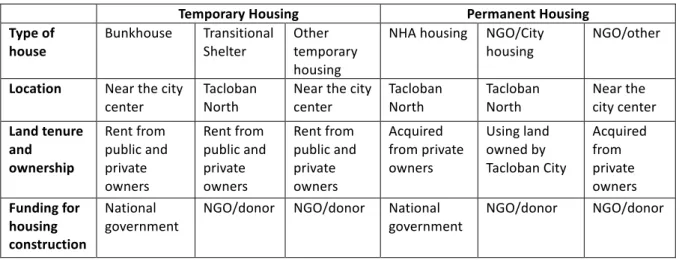
Figure 2.1 Map of Tacloban City showing the location of temporary and permanent housing
Tacloban City’s Office of Housing and Community Development became the coordinator for a complex process of providing different kinds of temporary and permanent housing, including varied and multiple actors, over multiple phases of housing recovery. They were also responsible for
coordinating with regional PARR and national departments to proceed with the plan and programs that developed. The City’s primary housing recovery scheme is a two-step relocation process; after staying in evacuation centers, residents move into temporary housing, and then later into new permanent housing.
The two main types of temporary housing are: 1) barracks-style wooden “bunkhouses” built by the national government on several sites near the city center, or 2) “transitional shelters”, primarily bamboo structures built by donor agencies/organizations on sites in Tacloban North. People who had evacuated to the larger city-designated evacuation centers and those considered to be more socially vulnerable were prioritized for the bunkhouses, which accommodated over 1,000 families in three sites. In addition to these two main types of temporary housing, support was also provided by NGOs and donors for temporary rental assistance and shelter materials for housing repair, and many residents rebuilt their own housing using a combination of provided, purchased, and recycled building materials.
The City considered the process of transition for evacuees, with the idea that the relocation process would be smoother for residents’ in terms of adjusting to new ways of living, by moving into transitional housing in the northern part of Tacloban and then into permanent housing in the same areas nearby. As of early 2016, the National Housing Authority (NHA) is constructing the majority of permanent housing, with over 13,000 housing units planned for multiple sites in the north. Other donor agencies and NGOs are constructing 1,600 units of planned permanent housing in North Tacloban on city-owned land. In addition, there are other non-profit organizations planning for new resettlement sites independent from the City’s support, closer to the city center (see Iuchi & Maly, Forthcoming). Table 2.1 shows housing types used during temporary and permanent phases, including information about their respective locations, land tenure and ownership, as well as funding sources.
Table 2.1 Housing types and details by temporary and permanent phases
Source: Modified from Iuchi and Maly, forthcoming.
Temporary Housing Permanent Housing Type of house Bunkhouse Transitional Shelter Other temporary housing NHA housing NGO/City housing NGO/other Location Near the city
center Tacloban North Near the city center Tacloban North Tacloban North Near the city center Land tenure and ownership Rent from public and private owners Rent from public and private owners Rent from public and private owners Acquired from private owners Using land owned by Tacloban City Acquired from private owners Funding for housing construction National
2.4 Status of housing recovery
Two years after Haiyan, 1,600 families were still living in various temporary housing provided by government or NGOs, and 500 families had moved into the first permanent housing units in Tacloban North (Iuchi & Maly, Forthcoming). These included houses built by NGOs and donors as well as houses in the first completed NHA resettlement sites. Residents have and continue to experience varied paths and processes in housing recovery, as shown in Figure 2.2, as they wait to find out what permanent housing may become available for them.
Figure 2.2 Overall displacement paths of residents in 5 targeted barangays (as of Jan 2016, based on interviews) back in Barangay back in Barangay back in Barangay back in Barangay Brgy 68 Brgy 31 Brgy 56-A Brgy 61 Apartment rental Apartment rental Apartment rental Apartment rental z back in Barangay Brgy 88 Bunkhouse A Bunkhouse I Bunkhouse N NGO/City GMA NGO/City GM NHA R NHA A NGO/City UNDP Independent NGOU Independent NGOC Independent NGOU CMPBE NHA G Transitional P Independent NGOU Bunkhouse A Bunkhouse I Bunkhouse N Transitional D Transitional OC Transitional OB Transitional T Transitional C Transitional B NGO/City GMA NHA R NHA A NGO/City UNDP NGO/City H Independent NGOU NGO/City L NHA s NHA D
2.5 Emerging Issues and efforts to alleviate problems
There are few precedents for housing relocation projects of the scale and complexity of that which is currently underway in Tacloban City. Although the coordinators of this resettlement planning and implementation are making intense efforts to integrate the various agencies and organizations involved, there are several issues that have emerged.
2.5.1 Stagnant infrastructure provision for living
Providing water to the new settlements in the northern part of Tacloban has proved to be an ongoing challenge. As an interim solution, water is being delivered by trucks with support from various donors. However, residents struggle with a limited supply of water, which was an often-reported reason for people to stay in or return to former communities. Similarly, electricity provision has been delayed. Until the provision of water and electricity are secured, the transfers of additional residents to housing in the northern part of Tacloban are on hold.
2.5.2 Lack of income generation opportunities
Some residents have created businesses in the new resettlement sites, such as sari sari (small scale convenience) stores, water selling, or pedi-cab (tricycle) or motorcycle driving. However, many residents are facing difficulties to find jobs in the northern part of Tacloban. Although various donors provided job training programs for those relocating, not much could be applied as there are minimal jobs available for new skillsets gained.
2.5.3 Increased expenditures to sustain lives
Since jobs that generate income are minimally available in the northern part of the city, many people have been making efforts to keep their original work. This is also the case for those who worked along the coast near downtown pre-Haiyan, in particular fisherfolks and fish vendors. For them, the distance from their new resettlement sites to former areas of livelihood activities is making them spend more. A large portion of their expenditures is for transportation for commuting back to their original areas.
2.5.4 Split and double households
Related to the lack of livelihood opportunities in the north, many families chose to stay in the former coastal areas even after they have received a permanent house in Tacloban North. In some cases, households are separated into those who are staying in the north and those who stay in former areas, or in some cases, most of the family stays in the new house while the breadwinners (especially fishermen) commute back to the coastal areas every day or several days a week.
2.5.5 Overall stagnancy of relocation
As a result of the suspension of additional transfers of more residents to the north because of the lack of access to water, the process of resettlement has stopped for the time being. In this context, residents who remain in coastal areas, included as eventual beneficiaries of permanent housing, are facing uncertainty about their future.
To proceed with more realistic development for living in the north, Tacloban City is near to completion of the Tacloban North Integrated Development Plan, which suggests needed utilities and services for relocating communities in the short and long term. Development so far had been based on the national reconstruction scheme, and this Tacloban North Development Plan aims to fill the gap of national programs with local needs. The discussion is underway on which infrastructure to be primarily installed (e.g. water supply, electricity and sewage management), what other urban services are needed (e.g. schools and health care) and how livelihood and job opportunities are to be supported. Efforts to bring this program together have been effective to understand the holistic progress of development at the local level, and the role of each department and agency to proceed with better rebuilding. It also had a role to acknowledge to national governments how relocation is not only housing construction and infrastructure development, but also about returning living patterns to normalcy.
References
GFDRR. (2015). In GFDRR (Ed.), Post Yolanda reconstruction case study (Revised final version ed.). Washington DC: World Bank.
Iuchi, K., & Maly, E. (Forthcoming). Residential relocation processes in coastal areas: Tacloban city after typhoon Yolanda. In Sapat, A. and Esnard, A-M. (Ed.), Coming home after disaster: Multiple dimensions of housing recovery. Boca Raton, Fl: Routledge: CRC Press.
National Economic and Development Authority. (2013). Reconstruction assistance on Yolanda: Build back better. Manila: National Economic and Development Authority.
Office of the Presidential Assistant for Rehabilitation and Recovery. (2014). Yolanda comprehensive rehabilitation and recovery plan. Manila: OPARR.
President of the Philippines, (2013). Providing for the Functions of the Presidential Assistant for Rehabilitation and Recovery (Memorandum Order no. 62, s. 2013), 69, Rehabilitation a d Recovery.
President of the Philippines, (2015). Providing for the Institutional Mechanism for the Monitoring of Rehabilitation and Recovery Projects, and Activities for Yolanda-Affected Areas (Memorandum Order no. 79, s. 2015), 79.
Tacloban City, (2013). An Ordinance Providing for a 40-Meter no-Build-Zone for Residential Housing within the Territorial Jurisdiction of the City of Tacloban, Ordinance No. 2013-12-15A.
3. Preliminary study on community leaders in evacuation
Yasuhito Jibiki and Shuichi Kure
3.1. AimThe Sendai Framework for Disaster Risk Reduction 2015-2030 (SFDRR) describes roles and tasks of community leaders. In SFDRR’s Priorities for Action, and specifically in Priority 2 “Strengthening disaster risk governance to manage disaster risk”, national and local levels “[a]ssign, as appropriate, clear roles and tasks to community representatives within disaster risk management institutions and processes and decision-making through relevant legal frameworks.” (Para 27.(f), UNISDR). The SFDRR is an outcome document of the United Nations World Conference for Disaster Risk Reduction, and its description is abstract rather than practical and technical.
Previous work regarding EWS (Early Warning Systems) mentioned the role of community leaders. Among the numerous extant studies regarding EWS, Sorensen and Sorensen (2007) and Mileti and Sorensen (1990) can be considered the most comprehensive to date. Sorensen and Sorensen (2007: 191) mentioned source credibility as one of the major factor for evacuation, and Mileti and Sorensen (1990: 2-9) indicated community opinion leaders as the source.
In the context of Typhoon Haiyan, Kure et al. (2016a: 1156) stated that the warning transfer system at the local barangay level requires improvement, and the capabilities and performance of barangay captains played important roles in ensuring appropriate evacuation of the barangay residents. Also, Kure et al. (2016a: 1156) emphasized that the warning transfer system should be designed so that the warnings can be delivered directly to local residents by the barangay captains or officials. Many people claimed that if they had received the evacuation order directly from the barangay captain, they would have evacuated. Furthermore, Kure et al. (2016b: 1640008-24) observed that barangay captains’ knowledge and leadership may reduce casualties in future typhoon events based on their questionnaire survey conducted in this study.
In summary, roles of community leaders in evacuation can be considered as very significant. Thus, in this report, we preliminarily and partially study roles of community leaders in evacuation. The term “community leaders” has a large variety of definitions and aspects (administrative, religious, informal and etc.). In this section, however, we consider barangay captains as community leaders.
3.2 Data for analysis
3.2.1 Questionnaire Survey
Data for analysis in this chapter is based on a questionnaire survey which was implemented as part of the IRIDeS Fact Finding Mission. The survey was conducted from March 14 to March 22, 2014, using questionnaires completed by and interviews with respondents. The geographic area targeted by the survey included four barangays in Tacloban City, three barangays in Palo Municipality, and three barangays in Tanauan Municipality. All the targeted barangays are located on Leyte Island, and they share the same coastline along Leyte Bay. These barangays are geographically close to one another and were exposed to similar hazard levels. We intended to survey 200 respondents in each of the three locations: Tacloban City, Palo Municipality, and Tanauan Municipality. The demographic characteristics of survey respondents were consistent with those of the population of the Philippines. Ultimately, the survey included 642 respondents.
3.2.2 Variables for analysis
In the present chapter, the authors specify 4 questions for analysis from the questionnaire survey. 1. Evacuation intention: Did you intend to evacuate to somewhere else except your
house?
2. Evacuation behavior: Where did you evacuate?
3. Evacuees who were told to do so by barangay captains: Why did you decide to evacuate to somewhere other than your house? (In this question, not all respondents answered. Those who answered “yes” in evacuation behavior responded to this question.)
4. How barangay captains were trusted: How much did you rely on Barangay leaders in order to get disaster related information such as typhoon warning? (In this question, the respondents selected one option from the following options: 1. Very high 2. High 3. Average 4. Low 5. Very low.)
3.3 Results
The analysis has two steps. The first step focuses on the barangay level and compares simple tabulation results of the targeted ten barangays. In the second step, the unit of analysis is individual respondents and it statistically examines the relationship between four variables which are generated by the four questions mentioned in section 3.2.2.
3.3.1 Barangay-level analysis
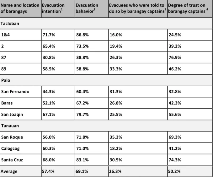
The barangay level analysis does not present clear relationships between the four variables. The result of Barangay 1 and 4 indicates that evacuation intention and evacuation rates are high, but these two variables seem to have a weak relationship with the factors on barangay captains (see Table 1 below). To the contrary, Barangay Santa Cruz in Tanauan has higher evacuation intention and evacuation rate and these two variables may have relationships with the barangay captain variables. A clear relationship is hardly observed among the four variables based on the results of the other eight barangays.
Table 3.1. Evacuation intention and behavior in relation with community leaders at the barangay level.
Source: Calculated and made by the authors.
Name and location
of barangays Evacuation intention1 Evacuation bahavior2 Evacuees who were told to do so by barangay captains3 Degree of trust on barangay captains 4 Tacloban 1&4 71.7% 86.8% 16.0% 24.5% 2 65.4% 73.5% 19.4% 39.2% 87 30.8% 38.8% 26.3% 76.9% 89 58.5% 58.8% 33.3% 46.2% Palo San Fernando 44.3% 60.4% 31.3% 32.8% Baras 52.1% 67.2% 26.8% 42.3% San Joaqin 67.1% 79.7% 25.5% 55.6% Tanauan San Roque 56.0% 71.8% 35.3% 69.3% Calogcog 60.3% 71.0% 18.2% 41.2% Santa Cruz 68.0% 83.1% 30.5% 74.3% Average 57.4% 69.1% 26.3% 50.2%
Note 1. The percentage represents the rate of answers of “Yes, I had a strong intention to evacuate to somewhere except my house.”
Note 2. The percentage represents the rate of answers of “Some places except my house.”
Note 3. The percentage represents the rate of answers of “Barangay leader told me to do evacuation.” Note 4. The percentage represents the rate of answers of “Very high” and “High” in the question “How much did you rely on Barangay leader in order to get disaster related information such as typhoon warning?”
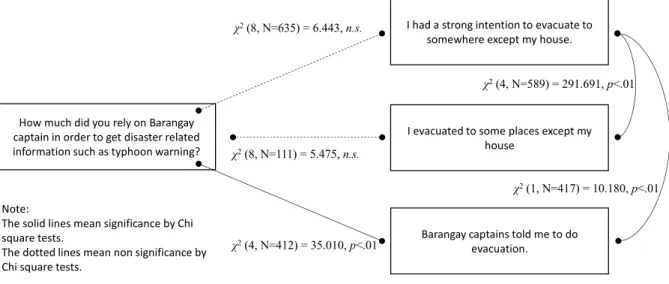
3.3.2 Individual-basis analysis
The individual-basis analysis demonstrates limited relationships among the four variables. A chi-square test revealed that “degree of trust on barangay captains in terms of disaster related information” does not have a statistical relationship with evacuation behavior and evacuation intention (see Figure 3.1 below). However, when we specified the target of analysis and selected only the respondents who answered that “Barangay captains told me to do evacuation,” the degree of trust of barangay captains is higher and this result is statistically significant. Based on these findings, we consider that the degree of trust of barangay captains and evacuation behavior are not unconnected, but the perception of only those who trust barangay captains is connected to evacuation.
Figure 3.1. Evacuation intention and behavior in relation with community leaders in individual-based analysis.
3.4 Conclusion
The barangay-level analysis shows that the relationship between evacuation and barangay captains is not clear. On the other hand, the individual analysis partially indicates that the higher degree of trust of barangay captains relates to evacuation. That results should be carefully interpreted because the barangay captain variables do not relate to evacuation behavior and intention if the analysis include all of the respondents. Thus, the analysis in this section suggests that barangay captains play important roles in evacuation, and at the same time their function cannot be said to be perfect.
These findings are not fully but partially consistent with the earlier work of Kure et al. (2016a: 1156). Furthermore, the finding in this section complement arguments of Kure et al. (2016a: 1156) and Kure et al. (2016b: 1640008-24) that think much of strengthening the capacity of barangay captains. Taking into consideration the limited effectiveness of barangay captains, other measures should be seriously considered in order to promote smoother evacuation. For more detailed and accurate analysis, other
Note: The solid lines mean significance by Chi square tests. The dotted lines mean non significance by Chi square tests. χ2(4, N=412) = 35.010, p<.01 How much did you rely on Barangay captain in order to get disaster related information such as typhoon warning? Barangay captains told me to do evacuation. I evacuated to some places except my house I had a strong intention to evacuate to somewhere except my house. χ2(8, N=111) = 5.475, n.s. χ2(1, N=417) = 10.180, p<.01 χ2(8, N=635) = 6.443, n.s. χ2(4, N=589) = 291.691, p<.01
variables should be included in this preliminary study, and the combination and interaction of variables requires further exploration.
References
Jibiki, Y., Kure, S., Kuri, M., and Ono, Y. (2016) “Analysis of early warning systems: the case of super-typhoon Haiyan” International Journal of Disaster Risk Reduction, Vol.15, pp.24-28. Kure S., Y. Jibiki, K. Iuchi, and K. Udo (2016a) “Overview of Super Typhoon Haiyan and
characteristics of human damage due to its storm surge in the coastal region, Philippines” Journal of Coastal Research, No.75, pp.1152-1156.
Kure S., Y. Jibiki, M. Quimpo, U. Manalo, Y. Ono, and A. Mano (2016b) Evaluation of the characteristics of human loss and building damage and reasons for the magnification of damage due to Typhoon Haiyan” Coastal Engineering Journal, Vol.58, No.1, pp.1640008-35.
Mileti, D. and Sorensen, J.H. (1990) “Communication of emergency public warnings: A social science perspective and state-of-the-art assessment,” Oak Ridge National Laboratory Rep. ORNL-6609.
Patterson, O., Weil, F. & Patel, K. (2010). 'The role of community in disaster response: conceptual models'. Population Research and Policy Review. 29(2). pp. 127-141.
Pelling, M. (2007). “Learning from others: the scope and challenges for participatory disaster risk assessment.” Disasters. 31(4). pp. 373-385.
Sorensen, John H. and B.V. Sorensen, (2007). “Community Processes: Warning and Evacuation,” Handbook of Disaster Research, pp. 183−199.
UNISDR. (2015). Sendai Framework for Disaster Risk Reduction. 2015-2030 (A/CONF.224/CRP.1). Waugh, W. L. & Streib, G. (2006). “Collaboration and leadership for effective emergency
4. Building schools back better in Tacloban City
Aiko Sakurai and Elizabeth Maly
Super Typhoon Haiyan, which struck the Philippines on November 8th, 2013, devastated Tacloban City. Housing and schools suffered heavy damage, and the education system was severely disrupted. As families move through the multiple phases of temporary to permanent housing, children’s schooling may also be disrupted, as they move to different schools. For families’ life recovery, decisions about schools and housing are closely connected in their decision-making process. The importance of this linkage between housing and education in the post-disaster phase is also emphasized in the Sendai Framework of Disaster Risk Reduction, adopted at the 3rd U.N. World Conference on Disaster Risk Reduction (UNISDR 2015). Based on a field visit to Tacloban in July 2015, 20 months after Typhoon Haiyan, funded by the International Research Institute of Disaster Science (IDIReS), Tohoku University, this section shares preliminary findings about the current learning environment at schools and children’s access to education in relation to relocation of families affected by Typhoon Haiyan in Tacloban City.
4.1 Damage to school buildings
After being hit by Typhoon Haiyan on November 8, 2013, schools in Tacloban City reopened on December 6, 2013, as a ‘soft opening’. At each school, damages among students were checked. Classes resumed on January 3, 2014 at the start of the new term.
4.1.2 Temporary classrooms
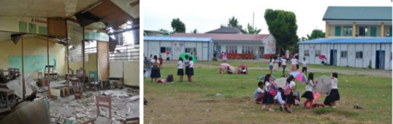
Temporary classrooms were provided by donors for schools whose classrooms were damaged, such as San Jose ES, where most temporary classrooms will not be used after the construction of new classrooms is complete. Temporary classrooms provided by the Red Cross on the grounds on San Jose ES will be dismantled shortly.
Figure 4.1 Damaged classroom (San Jose ES, July 2015)
Figure 4.2 Temporary learning spaces and newly built classrooms and reconstructed buildings in the school yard (San Jose, ES, January 2016)
4.2 Children changing schools as they move housing
As families moved several times to evacuation shelters, bunkhouses, transitional shelters, and permanent housing, children have also changed schools. From interviews with families in permanent housing settlements, parents made great efforts to keep children in school, even paying transportation costs by themselves. Some charities/NGOs provide school buses to take children from relocation areas in northern Tacloban to former schools in central Tacloban. However, among different schools and families, knowledge about such transportation services varies.
4.3 Schools face sudden and large changes in enrollment
At some schools near central Tacloban City, especially in or near Barangay 88/San Jose area such as Fisherman’s Village ES and San Jose ES, the number of pupils decreased sharply one year after Typhoon Haiyan. Conversely, at some schools near northern Tacloban relocation sites, such as at Lucio Vivero ES and Sto. Nino ES, the number of pupils greatly increased one year after Typhoon Haiyan and even larger increases were expected within 2015.
Tacloban City Department of Education (DepEd) has supported affected schools by relocating teachers according to the changing number of pupils, and by provision of additional financial support to repair classrooms (30,000 pesos per classroom) and purchasing learning and teaching materials for typhoon affected schools.
4.4 The role of donors in school construction
In the Philippines the education system uses school-based management. So the responsibility for finding donor support for school repairs and reconstruction falls to heads of schools. The role of DepEd is raising attention of donors and related agencies to demands for new schools, circulating the number of expected students, providing specifications and standards of school buildings, and allocating teachers to new schools.
Support from donors was extended to directly hit schools in coastal areas, such as Fisherman’s Village ES, where by the school head’s efforts, most repair work had been completed. However, due to the decrease in the number of pupils, some classrooms are not used. On the other hand, Lucio Vivero ES in North Tacloban could not receive enough support from donors to match the rapid increase in the number of pupils and high demand for additional classrooms. Since the construction of new schools is planned within permanent housing settlements, increases in the number of pupils at pre-existing schools near the relocation area, like Lucio Vivero ES, are expected to be temporary.
4.5 The massive relocation to North Tacloban means an urgent need for new schools in the north The need for school buildings in new locations is more urgent that usual school construction. Since DepEd could not finance building new schools at this time, school land and buildings are provided through various support and coordination with support from local government and other agencies and donors involved in housing construction.
The first permanent housing completed was built by the non-profit foundation supported by the Global Media Alliance (GMA) company, and also by Habitat for Humanity, on land owned by Tacloban City. There are already approximately 500 households living in these houses, and GMA will also support the construction of a school in the center of this settlement.
A larger number of permanent housing units will be built by the National Housing Authority (NHA) in multiple developments; several are planned to be complete by the end of 2015. School sites are included in central areas of five of these planned settlements: 1) Ridgeview, 2) Atlantic (Suhi) SDP, 3) North Hill Arbour (1&2), 4) Greendale Residence 2&3, and 5) Guadalupe Heights 1&2.
Tacloban City organizes a weekly coordination meeting called “Tacloban North Development Meeting” to identify, share and discuss issues raised in the course of reconstruction with the agencies involved. In July 2015, building new schools in relocation sites was an item on the agenda list, and Tacloban City DepEd is a member of the meeting along with Tacloban City Housing and Community Development, Planning Department, the Mayor’s office, Engineers, Architects, Health and Social Services. This meeting is an excellent example of multi-sectorial coordination needed to face the challenges of reconstruction holistically, including education as well as housing and infrastructure. 4.6 Findings and suggestions from the July 2015 survey
• The need for urgent and rapid provision of schools and school buildings requires additional coordination than the regular provision of schools. Classroom construction/ expansion based on the actual number of students enrolled lags behinds actual needs.
• Reliance on donors for building construction works well to repair damaged schools in the disaster area, but new schools or those with swelling enrollment in North Tacloban face difficulty in attracting the same support.
• How to meet such temporary and sudden increase of pupils’ numbers in schools near relocation sites should be carefully examined, and support from DepEd and donors should consider how to support this situation. This is not an issue for only heads of schools to deal with, but requires coordination at a larger scale.
• Possible solutions could be: a) provision of temporary classrooms that are no longer in use at San Jose schools and other coastal schools; b) supporting transportation from permanent housing complexes to schools in coastal areas until new schools will be ready within the housing complex. 4.7 Updates from the second field visit in January 2016
In the “Tacloban North Development Meeting” held on January 27, 2016, coordination of demolishing and transferring temporary learning facilities to the northern area and setting strategies for new school construction were major agenda items in the education sector. Since there were no DepEd representative in attendance at the meeting, it was not clear how the coordination has been made to move the agenda forward. There is some progress to demolish and transfer temporary learning spaces (TLS) to a newly constructed permanent housing site, Ridgeview, as of January 2016. However, there were also calls that immediate action was required to avoid a school crisis in the relocation places. This is an example that requires coordination between housing and education sectors for build-back-better. Access to children’s education opportunities should not be limited by the relocation of living places. Continuous follow-up is needed by carefully examining how the reconstruction process helps people feel they are able to build back better.
Figure 4.3 Newly built classrooms (Lucio Vivero ES, January 2016)
Figure 4.4 Demolished TLS materials in Ridgeview (January 2016)
References
Department of Education, Republic of the Philippines, website (http://www.deped.gov.ph) UNISDR (2015). Sendai Framework for Disaster Risk Reduction 2015-2030.
5. IRIDeS/Tacloban City Workshop and Knowledge Sharing
Co-sponsored by IRIDeS and Tacloban City, the “Reflecting on Yolanda ~for saving future lives” Workshop was held on October 12, 2015 (Appendix 1). The aim of this workshop was to share the experience and lessons from Typhoon Haiyan to minimize losses from future disasters. Including participants from local municipalities including Tanauan Municipality, Palo Municipality, Tacloban City, the Philippines Department of Public Works and Highways (DPWH), the Department of Education (DepEd), the Philippine Atmospheric, Geophysical and Astronomical Services Administration (PAGASA), University of the Philippines, JICA and others, over 65 people were in attendance. After presentations from Tacloban City about the current situation of recovery, IRIDeS members shared research results from the Philippines and Tohoku, followed by discussion.
6. Disaster Education Training and Handbook
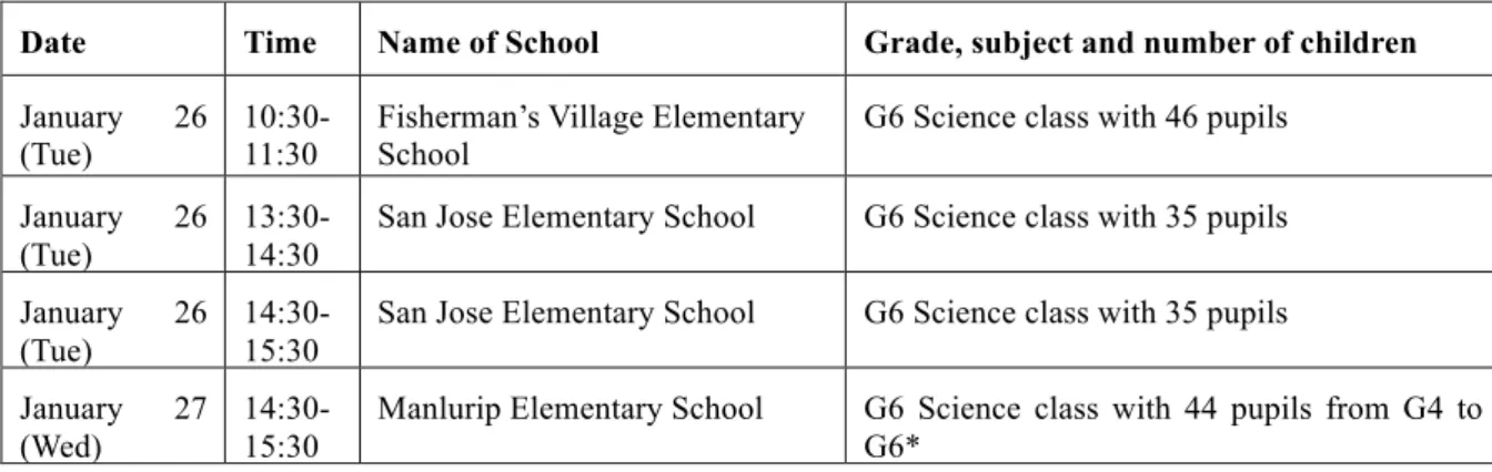
Based on findings from the IRIDeS fact-finding missions in 2013-2014, the team produced typhoon disaster education materials that explain the science behind typhoons and safe evacuation practices, targeting elementary school students. Through cooperation with DepEd, this material was tested out in the classroom through guest lectures to 6th grade science classes at three elementary schools in
Tacloban City in January 2016 (Table 6.1).
Table 6.1. List of schools where guest lectures were conducted using the education material
Date Time Name of School Grade, subject and number of children
January 26
(Tue) 10:30-11:30 Fisherman’s Village Elementary School G6 Science class with 46 pupils January 26
(Tue)
13:30-14:30
San Jose Elementary School G6 Science class with 35 pupils January 26
(Tue)
14:30-15:30
San Jose Elementary School G6 Science class with 35 pupils January 27
(Wed)
14:30-15:30
Manlurip Elementary School G6 Science class with 44 pupils from G4 to G6*
* Due to heavy rain, there were not enough G6 students attending school. Therefore, 4th and 5th grade students also participated in the class.
Though science classes at Philippines’ elementary school are taught in English, a Tagalog version of the material was also prepared for expected further dissemination to a wider audience, such as community people. Both English and Tagalog versions are available from the website of the International Collaborating Center of Disaster Education Research and Implementation (ICCDERI at IRIDeS http://irides.tohoku.ac.jp/topics_disaster/haiyan-typhoon.html and is included in Appendix 2 of this report.
7. Publications (Journal articles, book chapters, and international conference proceedings)
Iuchi, K. (2016). “Governing community relocation after major disasters: Three different approaches of Japan, Philippines and Indonesia,” Proceedings of the 8th National Social Science Congress: Batangas, Philippines.Iuchi, K. and E. Maly. (Forthcoming, 2016) “Residential Relocation Processes in Coastal Areas: Tacloban City after Typhoon Yolanda.” Chapter 14 in: Sapat, A. and Esnard, A-M. (Eds.). Coming Home after Disaster: Multiple Dimensions of Housing Recovery. Routledge: CRC Press. Boca Raton, Fl.
Iuchi, K. and Maly, E. (2016). “Relocation dynamics of informal settlers after the 2013 typhoon Yolanda – a two-year report.” Proceedings of the AAG Annual Meeting: San Francisco.
Iuchi, K. (2015). “Relocation in recovery after large scale disasters: Initial effort on coastal relocation in post-Haiyan Tacloban, the Philippines.” 55th Annual Association of Collegiate School of Planning (ACSP) Conference, October 22, 2015, Houston, Texas.
Jibiki, Y., Kure, S., Kuri, M., and Ono, Y. (2016). “Analysis of early warning systems: the case of super-typhoon Haiyan” International Journal of Disaster Risk Reduction, Vol.15, pp.24-28.
Kure S., Y. Jibiki, and K. Iuchi. (2015) “Overview of storm surge disaster caused by Super Typhoon Haiyan in the coastal region of Leyte, Philippines,” Proceedings of the Vietnam-Japan Workshop on Estuaries, Coasts and Rivers 2015. October 2015.
Kure, S., Jibiki,Y., Iuchi, K., and Udo, K. (2016). “Overview of Super Typhoon Haiyan and characteristics of human damage due to its storm surge in the coastal region, Philippines.” Journal of Coastal Research, No.75, pp.1152-1156.
Kure S., Y. Jibiki, M. Quimpo, U. Manalo, Y. Ono, and A. Mano (2016). “Evaluation of the characteristics of human loss and building damage and reasons for the magnification of damage due to Typhoon Haiyan” Coastal Engineering Journal, Vol.58, No.1, pp.1640008-35.
Kure S., Y. Jibiki, M. Quimpo, S. Kato, A. Mano, and Y. Ono. (2015). “Overview of Typhoon Haiyan and Reasons for Magnification of Damage due to Haiyan.” AOGS 12th Annual Meeting. Aug. 5, 2015.
Kure, S. Y. Jibiki, and K. Iuchi. (2015). “Lessons learned from Typhoon Yolanda and future challenges for Disaster Risk Reduction.” APRU Multi Hazard Symposium. October 9, 2015. Maly, E. and Iuchi, K. (2015). “Tacloban Post-Yolanda: Internationally Unprecedented Post-Disaster
Housing Relocation,” 11th APRU Multi-Hazards Symposium, October 9, 2015.
Sakurai, A. (2016). “Challenges in the Process of Education Recovery after Disaster: The Case of Public Elementary Schools in Tacloban City, Philippines, after Typhoon Haiyan,” Japan Comparative Education Society Meeting, June 6, 2016.
Previous year’s reports:
International Research Institute of Disaster Science. (2014). IRIDeS Fact-Finding Missions to
Philippines (First Report). Sendai: Tohoku University.
http://irides.tohoku.ac.jp/media/files/IRIDeS_Report_Haiyan_20140527.pdf
IRIDeS. (2015). IRIDeS Fact-Finding Missions to Philippines (Second Report). Sendai: Tohoku University.
8. Appendices
Appendix-1: “Reflecting on Typhoon Yolanda” Workshop Flyer
Contact person: Dr. Shuichi Kure [email protected] +81-(0)22-752-2114
Reflecting on Typhoon Yolanda
~for saving future lives ~
1st Workshop organized and sponsored by IRIDeS/Tacloban City
Date: Monday, October 12, 2015 13:30-17:00 Place: Don Joseph Pavilion, Leyte Park Resort Hotel
Super Typhoon Yolanda, making landfall on November 8, 2013, devastated the Eastern Visayas and part of the Central Visayas in the Philippines. This super typhoon of unprecedented magnitude generated a storm surge that caused catastrophic destruction of the coastal areas in Leyte and Samar. To prepare for saving lives against future typhoon events, this workshop aims to share important lessons learned from Typhoon Yolanda. The current recovery progress of Tacloban City will also be presented as part of discussions about building back better.
Program
13:30 Welcoming Address Hon. Mayor Alfredo S. Romualdez (Mayor, Tacloban City)
13:40 Keynote Speech Dr. Vicente B. Malano (Acting Administrator, PAGASA)
14:10 “On-going recovery of Tacloban”
Development plan of the City Ms. Atty. Jenny Lyn M. Polistico-Manibay (Tacloban City) Housing progress and issues Ms. Ma. Lourdes Lagman (Tacloban City Housing and Development Office)
14:50 “Messages from the Barangays” 15:15 Coffee Break
15:30 “Learning from Typhoon Yolanda (IRIDeS’s findings) and some implications”
Preparation for future super typhoons Dr. Shuichi Kure (IRIDeS) Future Challenges for Disaster Risk Reduction Dr. Yasuhito Jibiki (IRIDeS)
15:55 “Experience to share from Japan”
Suggestions from APRU members and other stakeholders towards recovery process
Dr. Takako Izumi (IRIDeS) Tide embankment project based on decision of local communities Mr. Takuya Ito (IRIDeS) Town-watching and mapping program for the disaster-affected schools and children
Dr. Aiko Sakurai (IRIDeS) Revitalizing local economy with planning Dr. Kanako Iuchi (IRIDeS) Post disaster housing relocation: International comparison Dr. Elizabeth Maly (IRIDeS)
Appendix-2: Disaster education handbook 2016/7/7 1
Learning from
Typhoon Yolanda Experiences
to Save Future Lives
International Research Institute of Disaster Science, Tohoku University, Japan 1
INTRODUCTION
2
Affected by the 2011 Tsunami
©Google Map
Reuters
Many typ hoo ns attack the Philippines
Japan is also exp ected to b e attacked by super typhoon
What is a Typhoon?
3
Future Projected super typhoon (JMA)
©JMA ©PAGASA
A: Typhoon is a rotating, organized system of clouds and
thunderstorms that starts over tropical waters, and brings strong wind and heavy rainfall.
4 Typhoon Yolanda 5 Why did Typhoon Yolanda make such big damage to Tacloban? We have many typhoons every year…. Why did so much damage occur by Yolanda? www.baronservices.com. Google/Digital/Globe Google/Digital/Globe Before Yolanda After Yolanda 6
2016/7/7 1 Radar designed to withstand100 m/s wind was destroyed Strong Wind
Before AfterRadar isGone!!
Answer 1: Because of strong wind made by super typhoon 7 10 – 20 m/s 30 – 40 m/s ©JMA ©JMA 100 m/s = Super Express Train!! ©PAGASA Storm Surge Answer 2: Because of storm surge made by super typhoon 8 ©MLIT ©MLIT ©JMA ©JMA
Storm surge ishigh tide and large wavesproduced bystrong wind and low pressure during typhoons
Storm surges behave like tsunami. 9 High Tide Strong Wind Final Storm Surge Q: What was the route of Typhoon Yolanda? A or B? 1 0 A B Tacloban ©Google Earth 1 1 Yolanda Tacloban B Answer: B 1 1 Answer 3: Because the storm surge directly attacked Tacloban ©Google Earth Typhoon Yolanda 1 2 Do you think that a typhoon like Yolanda could come to Tacloban again? Yes, Yolanda was not the firs t super typhoon. In the Philippines, similar typhoons with storm surge occurred in 1897 and in 1912. Another typhoon like Yolanda could come again in the future.
2016/7/7
1
Typhoon Yolanda 1 3 What could we do to survive from such a typhoon like Yolanda?Can we predict a typhoon coming? This was the warning where Yolandais coming, butpeople didn’tunderstand. Track of Typhoon YOLANDA was predicted in advance, and weather agency issued a warning, but people did not understand themessage
coastal areas under signal #3 and #2 are alerted against storm surges which may reach up to 7-meter wave height.
YES WE CAN! 1 4 Forecast Actual route 8am, Nov. 8 Forecasting time: 8am, Nov. 7 Forecasted Landing time: 8am, Nov. 8 ©Google Earth
pWeather news tells you BEFORE the typhoon comes, pwhen a typhoon is coming, and how big it is pYou can get this information from TV, RADIO, INTERNET, CELL
PHONES, etc. in ADVANCE!!! Very IMPORTANT to collect Typhoon Information in ADVANCE 1 5 ©MLIT 1 6 What to do when I know a typhoon is coming!! Earlier evacuation saves your life! Listen to and follow Evacuation Warning. 1 7 How should we evacuate?
Evacuate to ”TALL” and “STRONG” buildings!!! Keep away from the river and the sea
Avoid strong wind and heavy rainfall ©JMA ©MLIT 1 8 Where did you evacuate when Typhoon Ruby (Hagupit) came? Find the designated evacuation place by discussing with your family and teachers.
2016/7/7
1
1 9 Before a typhoon is coming, prepare in advance! Discuss with your family and teachers Evacuation drill gives us preparation opportunityParticipate in evacuation drill Prepare an evacuation bag at home
©JMA
©ICHARM
Summary
We can predict a typhoon coming
A Super Typhoon like Yolanda could come to Tacloban again
Typhoon Yolanda caused big damages by storm surge and strong wind
Importan t to discuss with you r family about how to prepare for another typhoon in advance
2 0
References
Some of figures used in this handbook was copied from following materials:
• Min istry of Land, Infrast ructure and Transport and Tour ism Hokkaid o Regio na l Development Bureau, Japan
http://www.hkd.mlit.go.jp/zigyoka/z_jigyou/gijyutu/mizubousai.html
• Ministry of Land, Infrastructure and Transport and Tourism, Japan http://www.mlit.go.jp/river/kaigan/main/kaigandukuri/forKids/INDEX0.htm • Japan Meteorological Agency
http://www.jma.go.jp/jma/kishou/books/takashio/
• World Hand book on Local Disaster Manageme nt Exper iences for beginner s, ICHARM, Japan
http://reliefwe b.int/sites/reliefweb.int/files/re sources/ha ndb ook_on_ local_ disa ster_management_experiences.pdf
• PAGASA Role of PAGASA in Disaster Risk Reduction and Management 2 1
Acknowledgements
• We thank our counterparts in the Philippines for their support.
• This hand b ook was deve lop ed by D r. Aiko Sakurai, Dr. Eliza beth Ann Maly, Dr. IuchiKa nako and D r. Sh uichi Kure un der the Sp ecial Pr oject Re search of IRIDES, Tohoku University.
• Translat ion s from E nglish to Tagalog was made by M r. U-Nichols A. Mana lo of Tohoku University.
• If you need a PPT file with animations of the handbook, please contact us. • The characters prese nted in this handb ook were drawn by Dr. E liza beth Ann Maly.