CITATION
Hackett, B., E. Comerma, P. Daniel, and H. Ichikawa. 2009. Marine oil pollution prediction.
Oceanography 22(3):168–175, doi:10.5670/oceanog.2009.75.
COPYRIGHT
This article has been published in Oceanography, Volume 22, Number 3, a quarterly journal of The Oceanography Society. Copyright 2009 by The Oceanography Society. All rights reserved.
USAGE
Permission is granted to copy this article for use in teaching and research. Republication, systematic reproduction, or collective redistribution of any portion of this article by photocopy machine, reposting, or other means is permitted only with the approval of The Oceanography Society. Send all correspondence to: [email protected] or The Oceanography Society, PO Box 1931, Rockville, MD 20849-1931, USA.
OceanographyTHE OffICIAl MAGAzINE Of THE OCEANOGRAPHY SOCIETY
DOwNlOADED fROM www.TOS.ORG/OCEANOGRAPHY
G O D A E S p E c i A l i S S u E F E At u r E
Marine
Oil pollution prediction
AbStr Act. The ability to monitor and predict marine oil spills depends on access to high-quality information on ocean circulation. Global Ocean Data Assimilation Experiment (GODAE) systems provide data, with global coverage, for currents, temperature, and salinity in the open ocean, and are now being used in oil spill fate forecasting systems. This paper provides examples of how GODAE ocean forcing data are implemented in various oil spill modeling systems, including both through direct application and through nesting of local hydrodynamic models. Benefits of using GODAE data sets for oil spill modeling are improved prediction accuracy, global coverage, and the provision of alternative predictions for a given area.
iNtrODuctiON
Monitoring and forecasting the fate of marine oil spills is one of the most important applications for operational oceanography. Prediction services, whether national or commercial, play an important role both in decision making during incidents and in designing emer- gency response services.
Monitoring, predicting, and, to a certain degree, detecting marine oil pollution are best supported by reli- able and fast access to environmental
observations and predictions. Such data provide an overall picture of the present and future status of meteorological and oceanographic conditions. They may also be used to drive prediction models for pollutant fate, either directly or by providing boundary conditions to high-resolution nested models of local weather and ocean state. Thus, there is a need to make large, global geophysical data sets interoperable with regional and subregional (national) observing and modeling systems through the use of
standard formats and service specifica- tions. For the global and regional oceans, the Global Ocean Data Assimilation Experiment (GODAE) has been a major driver in the development and interop- erable dissemination of relevant data products, including, specifically, ocean circulation forecast data.
Oil spilled at sea is one of the most studied forms of marine pollution, due to the catastrophic and highly visible char- acter of accidents, as well as oil’s devas- tating effects on marine life. Because quick action can reduce the effects of spilled oil, the ability to forecast its drift and fate is needed by coastal societies, and many national services have been developed over the last few decades.
Oil spill forecasting is typically carried out using a numerical model of the weathering and motion of the oil in the sea. Weathering, which includes evapo- ration, emulsification, natural disper- sion, and other oil-specific processes, is b y b r u c E H A c k E t t, E r i c c O M E r M A , p i E r r E D A N i E l , A N D H i t O S H i i c H i k AwA
G O D A E S p E c i A l i S S u E F E At u r E
b y b r u c E H A c k E t t, E r i c c O M E r M A , p i E r r E D A N i E l , A N D H i t O S H i i c H i k AwA
OceanographySeptember 2009 169
Marine
Oil pollution prediction
components that have greatest scope for improvement, mainly because ocean forecasting is less skilful and mature than weather and wave forecasting.
Operational ocean prediction systems emerging from GODAE are, therefore, an important development. Primarily, these systems offer the promise of better forecast accuracy through the assimila- tion of available ocean observations, which are also a major GODAE contri- bution. At present, ocean models simu- late some components of the current field better than others: tides, wind drift, and coastal currents are rather well reproduced, while eddies and meanders are often poorly replicated. The quality of the derived oil spill forecasts thus depends on which current components are dominant in a particular area and the weight given to the ocean current data by the oil spill model. The reach of the GODAE systems is also important.
Geographically, they extend from basin scale to global, thereby facilitating truly global oil spill modeling capabilities.
Furthermore, their temporal reach at these scales is 10–14 days, which is considerably longer than the two to four days typical of national services.
It should be noted at this point that oil spill model systems may use GODAE ocean prediction data in two ways: (1) as direct forcing to the oil spill model and (2) as boundary conditions to higher-resolution local ocean models that, in turn, provide forcing data to the oil spill model. The latter approach—
nesting—is often favored because it allows more detailed information (such as coastlines) and exploits local modeling expertise. On the other hand, using the global- or basin-scale data sets directly may be the only recourse if
the oil spill forecast provider does not have access to high-quality nested local models for a given area.
Over the last few years, a number of oil spill monitoring and prediction providers around the world have imple- mented GODAE operational ocean data products to improve and enhance their services to authorities, industry, and the public. Somewhat different approaches have been taken concerning implementation of ocean forcing data. In the following sections, we describe four representative services, both to show the current state of oil spill prediction and to provide guidance for developing services. The example services are taken from diverse ocean areas:
• Northern European waters, where offshore oil production and transport are major industrial activities in a harsh environment, exemplified by the national service at the Norwegian Meteorological Institute (met.no)
• Southern European waters (including the Mediterranean Sea) and Western Pacific waters, where heavy tanker traffic and illicit spills pose a serious environmental hazard, exemplified by the national services at Météo-France (MF) and the Japan Meteorology Agency (JMA), respectively
• South American waters, where a rapidly expanding offshore petroleum industry is challenged by large depths and relatively sparse environmental information, exemplified by the commercial services provided by Applied Science Associates (ASA) We also include case studies illustrating the use of GODAE ocean data in oil spill incidents, both real and simulated, from marine transport (e.g., tanker accidents) and offshore production activities.
determined by the chemical properties of the particular oil type under the influ- ence of ambient environmental condi- tions. The most common numerical formulation for oil represents the oil mass as a cloud of discrete particles (or superparticles), each of which represents a volume of oil that is subject to weath- ering and motion induced by geophys- ical forces. Although the formulations of particles and weathering processes may vary considerably among oil models, all are critically dependent on geophysical forcing to determine the fate of the oil spill, especially its motion. Currents, waves, and winds are clearly the most important factors, but models vary widely in the forcing data they actually use. Early oil spill models parameterized all forcing from wind data, which was all that was readily available. More recent models are able to make use of external data sets for currents, surface wave energy, wave-induced drift (Stokes drift), air temperature, water temperature and salinity, and turbulent kinetic energy.
However, how these data are used varies considerably, depending on the param- eterizations employed by the particular oil spill model. These geophysical forcing data are usually obtained from numerical models for weather, ocean circulation, and waves. In some oil spill forecast services, the forcing data come from operational numerical models, and this trend will increase with further refinement of ocean model prediction capability. For an overview of oil spill modeling methods, see Galt (1994), Reed et al. (1999), and Hackett et al. (2006).
For oil spill prediction modeling, it is ocean circulation data—currents and, to a lesser degree, temperature and salinity—that are the forcing
NOrtHErN
EurOpEAN wAtErS Norwegian Meteorological institute Oil Spill Forecast System This system has been developed by combining the oil chemistry and modeling expertise at SINTEF (http://
www.sintef.no/Home/Materials-and- Chemistry/), a Norwegian industrial research establishment, with the weather and ocean forecasting expertise at met.no. By contract with national authorities, met.no is obligated to return a drift forecast in agreed format within 30 minutes of a request.
The oil spill fate forecast system consists of three components. The first is an oil spill fate model, called OD3D, which calculates the three-dimensional drift and chemical evolution of surface and subsurface oil in the guise of a number of “superparticles,” each of which represents a certain amount of oil or its byproducts. Approximately 70 different oil types have been imple- mented, each with laboratory-derived characteristics for evaporation, emul- sification, and natural dispersion. The second system component is geophysical forcing data, which is perhaps the most decisive component of the system; given the present context, it will be discussed more fully below. The third component is a user interface consisting of an on-call
duty forecaster, available 24/7/365, and an interactive Web service through which a user may order, monitor, and visualize a forecast run, as well as download data.
Geophysical Forcing Data
OD3D can use model data for currents, wave height, wave direction, Stokes drift, and winds; three-dimensional salinity and temperature data are also required in the case of a deep spill source. For meeting national responsibilities in Norwegian waters, forcing data are taken from met.no’s operational models for weather, waves, and ocean circula- tion in the region of Norway. These data are updated at least twice daily to yield 66-hour forecasts. In addition, analysis fields for the past seven days are retained in a fast archive so that events starting up to a week in the past may be readily simulated.
Experience with this system over many years shows that the most critical component for forecast skill is the accu- racy of the ocean current data applied.
OD3D is formulated such that the hori- zontal motion of the oil is determined by the ocean model currents, along with the Stokes drift from the wave model. There is no direct parameteriza- tion of drift on the wind vector, as in some other systems. Because ocean models are less mature (and accurate) than atmospheric and wave models, a major effort has been put into obtaining the best possible current data. The Marine Environment and Security for the European Area (MERSEA) project (http://www.mersea.eu.org) and met.no, together with partners MF and the University of Cyprus (OC-UCY), have investigated the benefits of applying current data from various MERSEA
ocean forecasting centers. Several MERSEA systems are major compo- nents of GODAE: Mercator (Global, North Atlantic, Mediterranean; http://
www.mercator-ocean.fr), the global Forecasting Ocean Assimilation Model (FOAM; Global, North Atlantic; http://
www.metoffice.gov.uk), Towards an Operational Prediction system for the North Atlantic European coastal Zones (TOPAZ; Arctic Ocean; http://
topaz.nersc.no), and the Mediterranean ocean Forecasting System (MFS;
Mediterranean; www.bo.ingv.it/
mfs/). Both direct application of the MERSEA current data to OD3D and nesting of met.no’s local ocean models in MERSEA/GODAE data have been studied. To access MERSEA and other forcing data in a robust, semi-automatic manner, a multisource forcing data preprocessor has been developed. This approach has a number of advantages:
it allows global service when combined with global atmospheric and wave data from the European Centre for Medium-range Weather Forecasting, it allows a “mini-ensemble” of forecasts when several data sets cover the area in question, and the same preprocessor may be used to force drift models for floating objects and ships and to allow consistent coupling of the drift models (e.g., oil spilling from a drifting tanker).
Users acquire data either by routine FTP delivery or by OPeNDAP on demand.
case Study: Statfjord A Accident During the MERSEA project, valida- tion exercises were carried out with the met.no oil spill fate forecasting system and several other systems, using various ocean forcing data sets, including MERSEA/GODAE data. By chance, a real oil spill occurred during Bruce Hackett ([email protected]) is
Senior Scientist, Norwegian Meteorological Institute, Oslo, Norway. Eric Comerma is Director of Programs, Applied Science Associates, Narragansett, RI, USA.
Pierre Daniel is Senior Scientist, Division Marine et Océanographie, Météo-France, Toulouse, France. Hitoshi Ichikawa is Senior Scientific Officer, Japan Meteorological Agency, Tokyo, Japan.
OceanographySeptember 2009 171
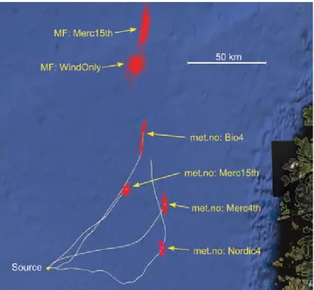
the project in Norwegian waters. On December 12, 2007, about 4000 m3 of crude oil were spilled from a ruptured loading line at the Statfjord field in the northern North Sea. Persistently strong southerly winds combined with the prevailing easterly currents would have been expected to give a drift toward the north-northeast. The actual drift was uncertain because the strong winds also led to rapid evaporation and natural dispersion of the oil, and hindered field observations, but hearsay indicated drift to the east-northeast and then to the north-northeast. Met.no ran forecast simulations using met.no forcing data (the national service), as well as alter- native simulations using a variety of MERSEA/GODAE data sets. MF also offered alternative forecasts. Figure 1 shows that there is a significant spread in the predicted mean trajectories of the oil slick, but the consensus lies in the northeast quadrant. Note that the national met.no service (“Nordic4”
in Figure 1) is at one extreme of the multimodel ensemble, while the MF forecasts are at the other extreme. This variation is a result of differences in oil spill models: surface drift is controlled more by the wind in the MF model (next section), while OD3D gives more weight to ocean model currents. An important conclusion of this case study is that a
“mini-ensemble” approach of this type gives valuable information to the duty forecasters who must provide guidance on the applicability and uncertainty of the numerical forecasts. The study also supports the finding from other MERSEA experiments that the best forecasts tend to come from simulations driven by data from local ocean models nested in basin-scale MERSEA/GODAE data sets (see next section).
SOutHErN EurOpEAN wAtErS Oil Spill Forecast System
at Météo-France
The system at MF is very similar in structure and capability to that described above for met.no, combining the oil chemistry expertise at the French national agency Cedre (http://www.cedre.
fr) with the weather and ocean fore- casting and modeling expertise at MF.
The MF oil spill model—MOTHY—
is also a superparticle-type model, but differs from met.no’s OD3D in that it relies more heavily on wind parameter- ization of the currents. MOTHY only uses ocean model data from a single depth—typically at the base of the wind- mixed layer—in place of a climatological
background current, and calculates the main drift component from the wind and tide data. It parameterizes upper ocean drift from wind speed using a sophisticated Ekman layer scheme.
The system’s user interface consists of a 24/7/365 duty forecaster and a Web service for online visualization and data download. MOTHY, using ocean-forcing data from MERSEA/GODAE forecasting centers, has been applied in several case studies during the previously described MERSEA project (Daniel et al., 2005).
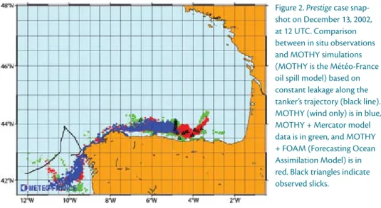
case Study: Prestige Accident On November 13, 2002, the tanker Prestige was damaged and came adrift off Cape Finisterre, Spain. Oil leaking from
Figure 1. Overview of Statfjord A oil spill forecasts as rendered in Google Earth. two Météo- France (MF) MOtHy and four Norwegian Meteorological institute (met.no) OD3D forecasts are shown, labeled with the ocean data used to force the oil spill models: bio4 = met.no model nested in GODAE/FOAM data. Merc15th = Mercator/GODAE N.Atl. Merc4th = Mercator/GODAE Global. Nordic4 = met.no standard model. The red clusters represent the predicted slicks on December 17, 2007, at 00 utc (4.5 days after the spill). Grey lines indicate the trajectory over the forecast duration (Nordic4 extends to December 19, 2007, 12 utc).
a gash in the hull caused a major pollu- tion incident, with oil slicks drifting over large distances and lasting several weeks.
Beginning on November 13, MF produced drift forecast charts for the authorities, including simulations using MERSEA/GODAE ocean data sets from Mercator and FOAM. The impact of adding these data was unclear during the first few days of the spill but became useful in the Bay of Biscay for longer simulations (Figure 2). It was concluded that the Mercator and FOAM contributions are valuable for long-term simulations in waters where large-scale circulation has a significant impact. These results were the first use of MERSEA/GODAE data and were most encouraging (Daniel et al., 2004).
However, they revealed large differences between the current data sets from Mercator and FOAM.
case Study: MErSEA Experiments in the Mediterranean Sea
During the MERSEA project, valida- tion experiments were carried out in two areas of the Mediterranean Sea with the MF and met.no oil spill forecasting
systems (MOTHY and OD3D, respec- tively, described above), supplemented by the system run by University of Cyprus (OC-UCY). The OC-UCY system is similar to MOTHY, but uses a high-reso- lution local model of the Cyprus region.
Oil-emulating surface drifters were deployed in autumn 2007, first southwest of Cyprus and later off the southern coast of France. The partners’ oil spill forecast services were applied to these “oil spills,”
facilitating a model-model comparison and model-data validation. Furthermore, the models were forced by several alter- native ocean data sets, including data from three MERSEA/GODAE systems:
Mercator Global (1/15°), Mercator Med (1/15°), and MFS (1/15°) (see Broström et al., in press, for a detailed description).
From analysis of over 100 simulations, the main findings are the following:
• In the Cyprus experiment, simula- tions by OC-UCY indicate that more accurate results are obtained when applying currents from a local, fine-scale ocean model nested in MFS basin-scale data as opposed to applying MFS data directly in the oil spill model.
• Around Cyprus, the three MERSEA/
GODAE data sets showed large differ- ences in predicted current fields. MFS and Mercator Med are both consid- ered eddy-resolving and assimilated the same data, yet the eddy fields they produced differ considerably.
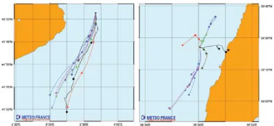
Mercator Global produced much smoother and weaker current fields due to lower resolution. The resulting drift trajectories vary considerably and often agree poorly with the drifters, as exemplified in Figure 3 (right). This discrepancy is especially the case for met.no’s OD3D, which relies heavily on ocean model currents to calculate the oil drift.
• Off southern France, drifters were deployed near Nice in the coastal current, which is a strong, persis- tent feature of the current field.
Here, simulations using OD3D and MOTHY with Mercator Med and MFS direct forcing agree much better, both with observations and with each other, as long as the drifters remained in the coastal current (Figure 3, left). Drift direction was generally well reproduced, but drift speed was underestimated in all simulations. In particular, MOTHY underestimated the drift if the chosen reference level for ocean data was below the coastal current.
• A common result from both experi- ments is that the drifter trajectories are better reproduced in areas where the ocean model data are most accu- rate (i.e., along coasts and in other areas where topographical steering is important). The larger discrepan- cies between drift predictions and observations found in open sea areas are due to unstable mesoscale dynamics (eddies, meanders), which
Figure 2. Prestige case snap- shot on December 13, 2002, at 12 utc. comparison between in situ observations and MOtHy simulations (MOtHy is the Météo-France oil spill model) based on constant leakage along the tanker’s trajectory (black line).
MOtHy (wind only) is in blue, MOtHy + Mercator model data is in green, and MOtHy + FOAM (Forecasting Ocean Assimilation Model) is in red. black triangles indicate observed slicks.
OceanographySeptember 2009 173
are not consistently reproduced in the MERSEA/GODAE ocean models (Figure 3).
• The Mediterranean experiments demonstrated the sensitivity of the drift forecasts to how the forcing data—currents, wind, and waves—
are applied in different oil spill model systems in order to calculate the drift.
The different approaches to forcing data application—strong dependence on ocean and wave model data (met.no’s OD3D), strong dependence on wind parameterization (MF’s MOTHY), and use of a nested, local ocean model (OC-UCY)—each resulted in superior simulation of the observed drift in some situations, but no single approach proved best in all situations. Having access to several different estimates—a mini- ensemble—was found to be beneficial for a forecasting service.
wEStErN pAciFic wAtErS Japan Meteorological Agency Oil Spill prediction Model
In the aftermath of several major oil spill incidents in 1997, including the major Nakhodka accident, when a Russian tanker broke up in stormy weather and spilled 19,000 kl of heavy oil in the Sea of Japan, the Japan Meteorological Agency (JMA) began developing a new oil spill fate prediction model, which became operational in 1998. The model is similar to MOTHY, using a surface advection component parameterized on the wind combined with deeper currents from an ocean model; a Stokes drift component derived from wave model products is also included. The specifications of the JMA operational model suite, including the oil spill model, are published at www.
jma.go.jp/jma/jma-eng/jma-center/
nwp/outline-nwp/index.htm. Since 1998, the oil spill model’s prediction accuracy has been improved, primarily as a consequence of improvements in the forcing data from JMA’s weather and ocean forecast models.
improvement of Ocean Forcing Data—the benefit of GODAE JMA develops and operates an ocean model and assimilation system in order to provide operational oceano- graphic information such as sea surface temperature and ocean currents. This assimilation system was upgraded recently (March 2008) from the older Comprehensive Ocean Modeling, Prediction Analysis and Synthesis System in the Kuroshio region (COMPASS-K) to the newer Multivariate Ocean Variational Estimation-Western North Pacific (MOVE-WNP) system. The upgraded system is contributed as a GODAE fore- casting system for the western Pacific.
In addition to increases in horizontal and vertical resolution, the main advance in MOVE-WNP is a new assimilation scheme, in which the vertical profiles of temperature and salinity from drifting buoys are correlated with satellite altim- eter data (Usui et al., 2006). This scheme can correct physical variables appropri- ately while maintaining a satisfactory dynamical balance. Furthermore, it is computationally efficient even though it retains nonlinearity. As a community for lively technical discussion, GODAE played an important role in devel- oping this scheme.
MOVE-WNP gives much improved simulation of the path of the Kuroshio Current on the continental shelf slope in the East China Sea, along the coast of the Tokai region of Honshu Island, and in the Tocharian Strait. The expression of small-scale meanders that propagate westward south of Shikoku Island and east of Kyushu Island is also improved.
Figure 3. Examples of comparisons of oil spill model forecasts with drifter trajectories from the MErSEA (Marine Environment and Security for the European Area) experiments in the western (left) and eastern (right) Mediterranean Sea for November 2007. Drifter tracks are shown by black lines with X marks for each day. Forecasts with Météo-France MOtHy using different forcing data: Dark grey = wind only (no ocean model data). Green = wind and climatological background current. red = wind and MFS (Mediterranean ocean Forecasting System) ocean model. blue = wind and Mercator Med ocean model. See text for model descriptions. Note the good agreement in the coastal current in the western Mediterranean, and the poorer agreement in the eddy-rich eastern Mediterranean.
case Study: impact of Ocean current Data from MOVE-wNp on Oil Spill prediction
JMA staff have never run the oil spill model in response to a serious oil spill accident. Therefore, model validation has only been carried out by comparison with drifters that were built specifically to move like spilled oil.
In November 2001, drifters were deployed in the East China Sea for comparison with oil spill model simula- tions. The oil spill model was driven by the COMPASS-K and MOVE-WNP ocean models. It should be mentioned that the other forcing data—winds and waves—were obtained from the operational models at that time, which means resolution was coarser than those of present models. In Figure 4, it is clear that the trajectory simulated by MOVE-WNP agrees better with the drifter than that of COMPASS-K.
Moreover, the turning point of the drifter track was quite reasonably simulated in the case of MOVE-WNP.
Comparative simulations of other drifter deployments and of the Nakhodka incident confirmed the superiority of MOVE-WNP data sets. It may be concluded that JMA’s new ocean model, with improvements based on GODAE results, has also improved the perfor- mance of the JMA oil spill prediction model significantly.
SOutH AMEricAN wAtErS In South America, national organiza- tions mandated to respond to oil spill events use a variety of oil spill fate modeling technologies, ranging from custom or commercial applications, to good-will access, to scientific expertise through international cooperation.
In contrast to the previous examples, such services are relatively new and are seldom developed by national agencies.
As described above, most modern oil spill models can use imported wind, wave, and ocean nowcast/forecast data to calculate oil spill fate predictions, and suitable global and regional data
products are increasingly being made available. However, these forcing data need to be readily available directly to the operational service providers as well as to emergency responders. A “middle user,” like ASA, can bridge the gap between data providers, on the one hand, and local service providers and users, on the other hand, by facilitating access to data with commonly used software tools and Web-enabled applications. Enabling easy access to GODAE data sets is an important component of data provision.
case Study:
Offshore industry in brazil In Brazilian waters, improvements in deep water exploration, drilling, and production techniques over the last five years have led to the development of previously inaccessible oil deposits. The complexity of deep water operations makes the integrity of wells harder to maintain, so the development of these new oil fields may pose a bigger threat to the environment. Rapid growth of the oil and gas sector has promoted the development of a specific environmental regulation framework by the Brazilian Environmental Agency, in collaboration with the Brazilian National Oil Company (Petrobras) and several other interna- tional oil companies.
Within this context, oil spill modeling plays an important role for contin- gency planning and as part of a deci- sion support framework in the case of an oil spill. A motivating event was a significant spill that occurred in January 2000, when more than 1300 m3 of heavy oil leaked from a refinery pipeline on Guanabara Bay in Rio de Janeiro. This event led to a series of extensive oil spill modeling studies that looked at potential spills from several refineries along the
127°E 128°E 129°E 130°E 131°E
27°N 28°N 29°N 30°N
31°N Figure 4. comparison of simu-
lated and observed drifter trajectories in the East china Sea, November 17–24, 2001. black circles indicate the drifter track.
Drifter simulations by the Japan Meteorological Agency oil spill model are shown in blue for the cOMpASS-k (comprehensive Ocean Modeling, prediction Analysis and Synthesis System in the kuroshio region) ocean forcing data and in red for the MOVE-wNp (Multivariate Ocean Variational Estimation-western North pacific) ocean forcing data. The trajectory curves include 12-hourly points for the observed and simulated positions (center of spilled area) at the same valid times.
OceanographySeptember 2009 175
Brazilian coast, as well as implementa- tion of an operational modeling system for areas of Petrobas operations. The latter system encompasses three compo- nents: atmosphere, ocean currents, and potential oil spills.
For the ocean current predictions, ASA has implemented a local ocean model, which is typically initialized and forced with climatological data for the region (see Beegle-Krause, 2003). One of the biggest challenges in implementing an operational ocean model in the South Atlantic region is the scarcity of data to calibrate and validate the model. To help meet that challenge, GODAE has a unique role in providing a suite of ocean data sets that are particularly valuable as nesting data to the local model. GODAE data take account of most of the avail- able observations and thereby represent a superior alternative to climatological data. Among the GODAE forecasting systems covering Brazilian waters, ASA has identified the HYbrid Coordinate Ocean Model (HYCOM) consortium (http://hycom.rsmas.miami.edu/) as a provider of trusted and extensively validated operational model results.
HYCOM data are readily accessible and they consequently play a key role in ASA’s implementation of operational ocean models at a regional level.
cONcluSiONS AND OutlOOk GODAE ocean data products have been shown to have a positive impact when implemented in existing national oil spill fate forecasting services as well as when initiating new services, both public and commercial. The main benefits of using GODAE data in oil spill modeling are:
(1) improved prediction accuracy, partic- ularly when used as nesting data for local high-resolution ocean models, (2) global
coverage, whereby any oil spill model can, in principle, be applied anywhere in the world ocean, and (3) facilitating alternative forecasts for an incident, both by providing alternative forcing data to a local oil spill model and by allowing other oil spill services to apply their models; single-model and multi-model ensemble forecasts become feasible.
Given the decisive role that ocean current data play in oil spill modeling, it is clear that future improvements in the quality of oil spill forecasts will primarily be a downstream effect of improved ocean model forecast skill. At present, that skill is not high, but it is improving. Continued improvements in GODAE forecasting systems are a necessary prerequisite for advancing the skill of oil spill fate predictions, regard- less of whether the data they provide are applied directly or indirectly (via nested, fine-scale ocean models). Furthermore, if GODAE data are to make a widespread impact, they must be accessible—easily, quickly, reliably, and freely. It is encour- aging to note that several concerted efforts, for example, the US National Oceanographic Partnership Program (http://www.nopp.org), the European MyOcean project (http://www.
myocean.eu.org), and the Australian BLUElink> project (http://www.cmar.
csiro.au/bluelink/), are underway to transition GODAE systems into fully operational services.
AckNOwlEDGMENt
The MERSEA Integrated Project was funded in part through the 6th Frame- work Programme of the European Commission.
rEFErENcES
Beegle-Krause, C.J. 2003. Advantages of separating the circulation model and trajectory model: GNOME trajectory model used with outside circulation models. Pp. 825–840 in Proceedings of the Arctic and Marine Oilspill Program 2003. Victoria, BC, Canada, June 10–12, 2003. Environment Canada, Ottawa, Ontario, volume 2.
Broström G., A. Carrasco, P. Daniel, B. Hackett, and D. Paradis. In press. Comparison of two oil drift models and different ocean forcing with observed drifter trajectories in the Mediterranean.
Proceedings of the 5th International Conference on EuroGOOS. Exeter, UK, May 20–22, 2008.
Office for Official Publications for the European Communities, Luxembourg.
Daniel, P., P. Josse, P. Dandin, J.-M. Lefevre, G. Lery, F. Cabioch, and V. Gouriou. 2004. Forecasting the prestige oil spills. Proceedings of the Interspill 2004 Conference. June 14–17, 2004, Trondheim, Norway. Available online at: http://www.interspill.
com/PDFs/UK/2004/402_DANIEL.pdf (accessed June 11, 2009).
Daniel, P., P. Josse, and Ph. Dandin. 2005. Further improvement of drift forecast at sea based on operational oceanography systems. Pp 13–22 in Coastal Engineering VII, Modelling, Measurements, Engineering and Management of Seas and Coastal Regions. C.A. Brebbia and M. Da Conceicao, eds, WIT Press, Southampton, UK.
Galt, J.A. 1994. Trajectory analysis for oil spills.
Journal of Advanced Marine Technology Conference 11:91–126.
Hackett, B., Ø. Breivik, and C. Wettre. 2006.
Forecasting the drift of objects and substances in the ocean. Pp. 507–524 in Ocean Weather Forecasting: An Integrated View of Oceanography.
E.P. Chassignet and J. Verron, eds, Springer, Dordrecht, The Netherlands.
Reed, M., Ø. Johansen, P.J. Brandvik, P.S. Daling, A. Lewis, R. Fiocco, D. Mackay, and R. Prentki.
1999. Oil spill modelling towards the close of the 20th century: Overview of the state of the art. Spill Science & Technology Bulletin 5(1):3–16.
Usui, N., S. Ishizaki, Y. Fujii, H. Tsujino, T. Yasuda, and M. Kamachi. 2006. Meteorological Research Institute Multivariate Ocean Variational Estimation (MOVE) system: Some early results. Advances in Space Research 37:806–822.