A Case Study f
o
r
Development
o
f
comprehensive S
e
i
s
m
i
c
Risk Assessment
一
一
一
Part2
Prevention of the earthquake disasterson the basis of the seismic risk assessment-一
Hitoshi
T
ANIGUCHI and Kumizi IIDA総合地震危険度評価法に関する研究
一一(その
2) 総合危険度評価に基づく地震災害の低減一一
谷 口 仁 土 ・ 飯 田 汲 事
This study is each composed of the part 1 and 2. In the part 1 of this study was previously published in 1986. The author;; were described the mechanism of damage occurrence and estimation method of earthquake damage in the study of part 1.
The prenent paper, part 2, described the preventive measures bas巴don the damage estima
-tion result in Nagoya city for the case study. Three types of earthquake damage are estimated in N agoya city. One of them is the totally destroyed wooden houses caused by th巴strongground
motion, liquefaction and man-made ground area. Second one is the fire damage such as outbreak and its spreading fire damage. Last one is the human damage such as loss of life. The comprehen-sive seismic risk in N agoya is assessed on the basis of addition to the various damages mentiond abov巴.
1.INTRODUCTION
Large earthquakes have frequently occurred in Japanese Islands, especially in the Pacific Ocean region. Nagoya city, the fourth largest city in Japan located halfway between Tokyo metropolis and Osaka city along the central Pacific Ocean coast, has su任eredfrom enoロnousdamages from past earth -quakes. N agoya city covers an area of about 320 square kilometers, the greater part of the ground being a thick alluvium. At present this city has a population of more than two millions. Moreover, the present circumstances have become quite di任erent
from the past ones, even from those of thirty years ago. Surrounding countηT areas have been converted
into urban areas and many houses have been built on undesirable places such as man-made slopes and riverbasins. Due to these developments, earthquake damage in N agoya is concerned in near future. The discussion of earthquake prevention has a very important significance in N agoya city, from because locality of Nagoya has three important cir -cumstances such as activity of earthquake around the city, construction of ground structure and locality
between Tokyo and Osaka city. And also, the charac -teristics of earthquake prevention factors which will be carried out from this case study will be able to apply the other cities.
2. EARTHQUAKE CIRCUMSTANCE
At first, in order to discuss the future earthquakes which will bring about damages in Nagoya city, it will be serviceable to reviews the past large earth quakes. Only the epicenters and magnitudes of the earthquakes, of which Japanese Seismic Intensities in Nagoya are great巴rthan V, are shown in Figure 1. Occurrence of earthquakes with magnitude great巴r than 8 (Ms scale) are distributed along the Pacific Coast, with the exception of the giantic earthquake with magnitude 8.4 (Nobi Earthquake) occurred in the inland area in 1891.The authors have tried to take those three earthquakes which are shown with black circles in Figure 1 as the case for the study of the damage estimation in N agoya city, and their fault models are shown in the same figure with squares目
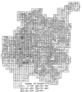
In the second place, the density of wooden house in each mesh area will be shown in Figure 2. The
150 Hitoshi TANIGUCHI and Kumizi IIDA
Figure 1 Distribution of th巴earthquakeepicenter
which bring about damages, and its fault models
Figure 2 The distribution of the density of wood-en house
crowded areas more than 900 hous巴sper mesh area
are included in a circle with a radius of about 7 kilometers. The 70 percents of crowded areas are concentrated in the north-western and south-eastern part of the ci ty
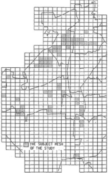
Finally, the whole area has been classified into six classes, depending on the ground structure as list巴din Table 1.As shown in Figur巴3,the classifica -tion 3 and 4 distribute from northern to western part,
and southern part in the city. In the eastern part,
classification 1 and 6 are concentrated
3. ESTIMATION OF EARTHQUA区EDAMAGEIN NAGOYA CITY 3. 1 Maximun response acceleration on the ground surface Seismic response spectra on the seismic basement are calculated by the equation1 (see part1)1)for ロ1 圏4 1:J2 図5 咽3 図6
Figure 3 The utiliz且tionof land depending on the
ground structure
Table 1 Ground classi品cationdepending on the its structure. classificat工on 2 否両叩ゴ亘E記己ture Tertiary and Diluviurn Alluviurn ( less廿1aTl1 0 meters) Alluviurn ( 10 to 20 meters ) Alluviurn ( more than 20 meters) RiverbョSln,seョsideand can且l Man -made grm旦Q_ 3 4 5 6
Table 2 The calculated r巳sults of m且ximum
acceleration in the seismic basement for the assumed earthquakes
assumed earthquakes shown in Figurel.Th巴results
of maximum acceleration values which are calculated at nine localiti巴s;four corners, one center and four
middle points of side line in Nagoya city and those are listed in Table 2. The calculated results of the assum巴dearthquakes in Table 2 are about 70, 100 and
120 gals2las an average data from nine localiti巴son
the Tertiary mentioned above sit巴s,respectively.
Authors use these values with calculation of damage estimation as following chapters. The various dam ages will be estimated to three assumed earthquakes,
however, their damages will b巴onlyshown in a case
of the assumed earthquake 2 in following sections In case of assumption which the ground structure in N agoya consists of flat layers, the maximum ac celeration on the ground surface is calculated by the multiplication of the maximum acceleration on the
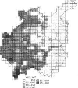
Figure 4 The calculated result of maximum res -ponse acceleration on the ground surface for the assumed earthquake 2. 1n a case of as -sumption which the ground structure is con sisted with flat layers
Figure 5 The calculated result of maximum res -ponse acceleration on the ground surface for the assumed earthquake 2. 1n a case of con -sidering the ground irregularity
seismic basement (see Table 2) and the the amplifica -tion factor in each mesh area for the assumed earth quake 2, and their results are shown in Figure 4.
The calculated maximum acceleration increases from the巴asternto the western part of the city. The maximum acceleration in the western part is more than 300 gals, but in the eastern part is less than 150 gals. Megascopically saying, this tendency is corre -sponding to change the thickness of the alluvium layer shown in Figure 3. And also this tendency agreed with the conclusion that is the eastern part part of the city to be relatively safer than the west巴rn side of the city concerning on the earthquake occur -rence 1n seismic response analysis of the man-made ground, the following investigations are done in Nagoya city (1) Distribution of slopes (2) Detailed field survey of the man-made ground,
including shape, g巴ologyand its form
Distribution of slopes is due to an aerial photographs. Th巴fieldsurvey is not necessary to collect data shape
and others, but also to judge wheth巴rthe slopes found
in photograph are man-made ground or not. The amplification factor of man-made ground is calcu lated on the bases of the above ground shapes. 1n the assumed earthquake 2, the calculat巴dresult of the
maximum acceleration is obtained by means of the multiplication of amplification factor in flat area and amplitude of man-made ground in each mesh area,
and is shown in Figure 5 By comparison the calculated maximum accele -ration on the ground surface in Figure 4 and 5 to the utilization of land in Figure 3, it is considered that the characteristics of seismic ground motion in a regional scale. By comparison the maximum acceleration shown in Figure 4 to the utilization of land in Figure 2す whenbefore the turning into housing lots, the geological condition from巴asternto western part in
N agoya starts from Tertiary to Diluvium through thick Alluvium. However, at present, we can find that there are many art凶cialflatted ground such as man made one at the eastem hill-side of the city. By comparison such former ground structure with esti -mated maximum acceleration shown in Figure 3, the maximum acceleration increases from the巴astern
part to the western part of the city and it was harmo-nized with th巴changeof ground structure as describ ed earlier.This tendency agreed with the conclusion that is the eastern part of the city to be relatively safer than the western side of the city concerning on the earthquake occurrence. However, it did not reveal the calculated acceleration depending on the present reconstructed ground structure and it di妊eredfrom
th巴resultsshown in Figure 4. 1n another word, the area with large acc巴lerationappears at the eastern part of the city, and the damage will be estimated at the eastern housing lots area Itcould not make the accurate seismic assess -ment with th巴responseanalysis which belongs to the
152 Hitoshi TANIGUCHI and Kumizi IIDA
Figure 6 The estimation result of wooden houses caused by strong ground motion and by li quefaction. to七ally ロ ・ 口 日 図 日 麗,,-Figure 7 The estimation result of wooden house caused by man-made ground destruction necessary to make the seismic assessment with the consideration of the topography and artificial ground structure such as man-made lands
3. 2 Estimation of wooden houses damage Concerning the totally destroyed ratio evaluated from equation16')(see part1), the number of totally destroyed houses has been calculated by multiplying the number of wooden houses with P
,
(a) and P,(l),and with P3(m) in each mesh area. The damage
distributions calculated from P
,
(a) and P,(l), and from P3(m) are shown in Figure 6 and in Figure 7. ByFigure 8 The estimat巴dresult of totally destroyed house due to earthquake 2 Figure 9 The estimated result of loss of life. comparison the estimated number of totally destroy ed houses caused by the maximum acceleration to the utilization of land, the number of totally destroyed house is considerably great at the area of the ground classification 3 and 4. In another word, the damage increased with increasing the thickness of Alluvium. Although the number of totally destroyed houses is very small amount and becomes less than 10 at the area of ground classification 3 and 4 at southern part of the city, this does not m巴anth巴lessdamage ratio
Figure 10 The ar巴awhich are estimated the fire
damage caused by sprεading
Figur巴 2 and the less amount of wooden houses
existing in those mesh areas. By comparison the distribution of the number of totally destroyed houses at man-made ground sites as shown in Figure 7 with Figure 6, at the eastern part of th巴city.it has been
believ巴d that th巴re seemed relatively small四rth
-quake damage because of hill side areas, but, it can not say d巴且nitelysafe as considering with the pres邑nt
situation of the developrr淀 川ofsocial circumstances at the eastern part of N agoya city
By using the synthesized various earthquake damages which are caused by maximum acceleration,
liquefaction and destructive man-made ground, the whole damage of totally destroyed houses is revealed in Figurで8.The r巴lativelyminor damage for wood巴n
houses is observed at the areas of both ground classi品一
cation 1 and 2 which are at th巴centerand the eastern
part of the city. The moderate damag巴isobserved at
the areas belong to both ground classification 3 and 6 On the other hand, the major damage is observed at the ground classi五cationof 4 and 5. 1n addition, the same degree of damage is found at the ground classiι cation 3 and 6. This means that the degree of earth quake environment at the ground classification 6 as that of the classification 3 (thickness of Alluvium is from 11 to 20 meters) is obtained the land dev巴lop
-m巴ntev巴nwith the originally hard ground structure
3国 3Damage estimation results of loss of life
1n Figure 9, the estimated results of number of loss of life in each mesh area is shown. The areas where the number of loss of lif巴isestimated more
than 11 are mainly concentrat巴din the north-w巴stern part of N agoya city.
=
L~ SPREAO I NG AREA (j~) 回 包 囲 血 ← 田m
由一田 園 05-.Oo 回 目 ー 田 園 佐H
土土仕士七
L 存 FigUI・母11 The estimated result of spreading日目 damage 5生5 1 3 311 413[1 6 614 1 4 3 1 4 ドト』-『-hRAm0k K D N: F S P R E AD I N G AR E A た 四1m包1 R副k "百1,"1 ー自国 4: a:Xll-虫 四 1ヨ刃1-6(阻 止 質 問-HX回 Z庄))1-7庄:0 6:1αX11-1100J 3:7田1-1沼)J 7:11田 トFigure 12 The risk of五re damage bases of the spreading fire area
3, 4 Damage estimation of outbreak fire且nd
spreading area
1n Figure 10, the estimat巴dresult of the number
of outbreak fire in each mesh is shown on the bases of equation 27, 28 and 291)(s巴epart 1). In addition, the
damage estimation result of fire spreading is evalua -ted in the mesh which is shown in Figure 10 based on both the damage of outbr巴akfire and the in日uenceof
the residential enviroment consisting of the house crowed ratio, the vacant land, the str巴am,and so on The area using damage estimation is 15.25 km2
154 Hitoshi TANIGUCHI and Kurnizi IIDA Table 3 Classification of the damage rank Vari∞sclar国qe I C1assification of clar田ge田d色gr自 ofrank. P且Xll!1Urn (gal ) -150 151-200 201 ・250 251-300 301-350 351-400 401-450 451 -acce1eration Rank.
。
4 6 日 10 12 14 τbta11y destroyed。
1-5 6-10 11-50 51-100 101-500 50ト.700 701 -w:x泌enhouse Rank.。
l 2 3 4 5 6 7 Number of 10ss 0。
1-5 6-10 11-20 21曲35 36-50 51-80 81 -1ife Rank.。
l 2 3 4 5 7 Damaged area of ( x1o'lm2) -5 5-6 6-7 7-8 8-9 9-10 10-11 11 -sprea也Jngfire Rank.。
6 8 10 12 14 Table 4 Earthquake risk assessment according to the total value of damage rank.hEr
R21な
12凶│
ぉi副 c1此 聞 はY血dg田 町alremark.sof vario四 品mages 0 0 1 白 血nicIntensity is 1essthan N. Da田ge1S extr園 田ly1側 . 1 1 - 5 1 ぉi田nicInt官 官ityisaix>ut V. 0宙 国geofwoodenhol坦eis only presumed. 2 6 -10 Sei田nicIntensity is lessthan middle VI.α::currence of也mageto wooden hol坦e田d10 ss of 1ife is pr自 国ad. 3 11 -15 Seismic Intensity is middle VI.Possibility of clar田ge出 口 1 rrencetowooden M叫se,10ss of 1ife田d∞tbreak.fire is relative1y hight. 16 -20 Seismic Intensity is rror'哩 thanmiddle V工.P<コssibilityof alldan百geoccur -E回 目 isextremely hight,加t,clar田geof spreading fire is盟 国11. s 21 -36 Seismic Intensity is VII.Possibility of a11 d町 田geoccurrence is extr園 田 -lY hight, esp田ially, 品 目geof sprea也ngfire is gr白 t. The estimated results on spreading fire after 60 minutes from outbreak fire is shown in Figure 11.On the north westem part of Nagoya city, there are many areas where the spreading fire area per one mesh reveals greater than 0.03 km2. It can be seen thatthe spreading fire area is approximately 7 per cents and 13 per cents of the damage estimation area under the wind velocity of 3.7 m/sec and 10.0 m/sec, respec -tively. Here, authors estimated the spreading area mentioned above, has been estimated regarding many number of outbreak fires. Therefore, it has been converted into the spreading area per mesh and per outbreak point. The risk of spreading fire shown in Figure 11 under the condition of the wind velocity of 3.7 m/sec and 60 minutes after outbreak evaluated. The risk of spreading fire is classified into 8 grades and each value is given in Figure 12. There are 15 meshes for the rank of risk having more than 5 and it becomes approximately 25 percents of the whole meshes in the city. Regarding the area having the rank of more than 5, the half of those areas is concen -trated in the north-westem part of Nagoya city and the risk of fire caused by earthquake is relatively high with respect to the other parts
3. 5 Earthquake risk assessrnent by synthesizing various darnage
The calculated response maximum acceleration at the ground and the estimated various damages are classified into the rank from 0 to 14 which is corre -sponding to their degree (see equation 34 in part1)1),
and is given in Tabl巴3.Here, the rank of maximum
accel巴rationand of spreading fire are greater than the
others. This reason is that the all earthquake dama ges are mainly govemed by the maximum accelera -tion~t the ground, and the spreading fire damage is seriously a妊ectedwith people's property and life,
moreover, spreading fire has a strong possibility in the development of the damaged area as known from the past earthquakes such as The Kanto Earthquake in 1923
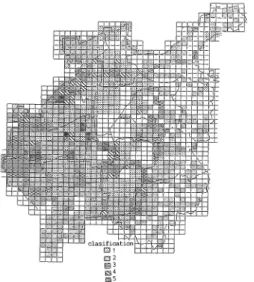
The earthquake risk is numerically obtained .by using the total rank value which is given by the summation of various damage rank. The assessment on the bases of this earthquake risk is consisting of six degrees depending on the range of total rank value as shown in Table 4. The minimum earthquake risk 0 which total rank value means zero is the most safe assessrnent which seismic intensity is less than IV and the possibility of damage occurrence in this risk area may be extremely low. The maximum risk 5 which total rank value is more than 21 shows the most danger assessrnent which seismic intensity is VI This rank 5, also, including the high possibility of all earthquake damages with special referrence of sprea -ding fire. The distribution of earthquake risk value in each mesh area is shown in Figure 13. As will be seen in this figure, the westem and north-western parts in N agoya are evaluated as dangerous area where the earthquake risk is greater than 3. Especially, in the
Figure 13 Evaluated the earthquake risk value in each mesh area
north-western site among areas mentioned above, its risk is given as the highest value of 5 and this site will be considered that the disaster potential is the grea -test in the ci ty
On the other hand, the earthquake risk value in the eastern part of the city is less than degree of 2. By comparison with this risk and ground utilization (in Figure 3), it is clear that the reagion the risk 2 in the eastern side of the city mainly dues in thedeveloping area where is truning the natural land into man-made housing lots. Therefore, the city planning in future should be requir巴dto prevent from th巳 earthquake
disaster in concerning with the man-made ground in mentioned above area
The lower value of earthquake risk 0 or 1 ap -pears at the center and eastern part excepting th巴
man-made ground area in the city. The ground struc ture of those areas is consisting of hard soil layers,
and there are few wooden houses with r巴spect to
other parts
On the basis of this earthquake risk assessment,
the western and north-western part may be evaluated the most dangerous areas in N agoya. In the eastem part, there is high risk due to man-made ground, but,
other area except man-made ground is relatively minor risk. The central part of the city is assessed the most safe area in N agoya city. 4. DISCUSSION Although the degree of earthquake risk is estima -ted as shown in Figure 13 in a case of an earthquake with the acceleration, 100 gals, of incident wave in the seismic basement, it is n巴cessaryto consider reduc tion of the earthquak巴risk for future earthquake 10
年 ぷ
f
l
バ
ダ
グ
リぷぬよ
?
[
d
J
6
3
;
γ
/
Bl.Oト / / ノ ノ!日 5~/fう令iム
刊 己
f e J J 日羽岡q出pr由 討 記Figure 14 Estimated result of various damages for 3 assumed earthquakes
prevention project. Hence w巴aretry to elucidate the
reduction factors respect to the earthquake damage and total risk by ground condition, maximum accele ration and soil circumstances. After we analyze the estimated various damages in detail and obtain the reduction factors, we should discuss the possibility of earthquake risk
As the earthquake damage is clearly depended on the acc巴lerationon the ground, relation betwe巴neach
earthquake damage and maximum acceleration of the incident wave are plotted in Figure 14, in which the maximum accelerations are of assumed earth quakes in Table 2 and damage ratios are th巴average
one in all the meshed areas
Damage of wooden hous巴sby seismic vibration
and liquefaction, damage of wooden houses on man-made ground and loss of life increase exponentially against the maximum acceleration and their patterns are quite similar each other.However, the burnt ratio and fire spreading ratio are almost constant at the acceleration of 70 to 100 gals and increase at 120 gals This tendency is depending on a number of outbreak fire. N amely, the burnt and fire spreading ratios are controlled by the destroyed ratio of wooden house. They increase rapidly when the totally destroyed ratio exceeds a certain value
When we pay aUention on the occurr巴ncetypes
of damage by the incident wave, we can五ndthat it is necessary at first to reduce the damage by outbreak and spreading fires for the regional巴arthquakepre
vention. In other words, w巴shouldconsid巴rto r巴duce
the destroyed ratio of wooden houses and to promote construction of fire-proof houses and open space. Here we analyzed various damage in detail taking into consid巴rationof the destroyed and mixed ratio of
Hitoshi T ANIGUCHI and Kwnizi IIDA Z O E ﹂ F d 3 E コ 色 去 ︿ 156
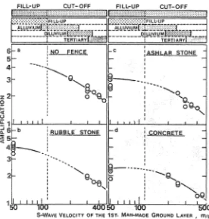
Figure 16 Relation between Vs of man-made grou -nd a-nd amplification in each case of protec tion fence of slop巴
2 3 4 5 6 Ground Classification
Figure 15 Relation ship between classified ground and prequency of damage occurrence in each rank of damage. Figure 17 Frequency of amplification in each type of fence wooden house in m巴shedarea. Prevention project for liquefaction is inevitable at the former case, and at the latter case, we should keep the man-made circum. stance of wooden house population or construct house after improvement of the ground for liqu巴fac
tlOn
Prevention guide in the ground (6), i. e, man-made ground, is deduced from the following.
(a) Figure 16 show relation between S-wave velo city (m/s) of man-made ground and amplification in each case of protection fence of slope.Itis clear that amplification decreases with increase of S-wav巴V巴 10-city in eve勾Tground and decreas巴by the fence
Compareing with amplification in no-fence ground to concrete fence ground, the latter is about 60% of the former one. The amplification decrease is large parti cularly in fill-up ground (b) Figur巴17shows fr巴quencyof amplification in each type of fence. Very high amplification, more than 3, is observed in no-fence cut-off ground and ashlar and cobble stone fence fill-up grounds On the other hand, amplification is less than 3 in all the concrete fence ground. Hence it can be con cluded that concrete fence in both the fill-up and cut. o百groundswill be e紅白tivereduction of the amplifi
4昭 1Totally destr明r母dratio of官。odenl:wuse
Investigating which factor旦百ectthe damage of wooden house, we draw Figure 15 where the relation ship between classified ground and frequency of damage occurrence in each rank of damage defined in Table 2. The frequency, p(i, j), is defined as follows ;
p(i, j)=n(i, j)/N(i)xI00・ --. ・・ ・ 一(41)
where N (i) is total numb巴rof mesh ar巴aswith
dama-ge rank i (Table 3) and n(i, j) is number of the areas with damage rank i and classified ground j. Although the grounds with high p(i, j) value are different from each cas巴ofdamage rank, the larg巴valueof p(i, j) are
seen in the cases of ground (3), (5) and (6). P且rticularly
in ground (3), p(i, j) at damage rank (3), (4) and (5) are high, whereas, damage rank (1) and (2) occur frequen tly in ground (6)
Figur巴15shows that damage ratio is rare in the
ground (1) and about 46% of the ground (4) is suffer巴d
from damage rank 3. Roughly spεaking, damage ratio is high in the ground (3) and (4). Damage rank 1 and 2 showing low damage occur frequently in the ground (2) and (6). Frequency of damage rank (3) is also high in the ground (6)
Based on the occurrence of damage of wooden house, we consider the prevention for future earth quake damage. When we try to constrain total dama-ge ratio within 20
,
%
it is necessary to prevent the earthquake damage for the ground (3) to (6). As the ground (3) and (4) are composed of thick Alluvium layer and reforms of the ground are realistically improbable as pr巴ventionproject, we should concentrate to improv巴earthquake-proofof wooden house.
In the ground (5), damage rank 3 is caused by liqu
40
20
0
0 1 2 3 4 5 6
Damage r面1k.of house
Figure 18 Relation betwe巴n the rank of totally
destroyed and rank of fire damage
cation. As a realistic earthquake prevention, it will be necessary to use the concrete fenc巴atleast in fill-up
ground
4. 2 Damage of outbreak fire and spreading Although the damage by outbreak fire and th巴lr
spreading relate indirectly to the amplitude of ground motion, the direct causes of outbreak fire are consi -der巴das the breakdown of wooden hous巴sand the
dangerous fire materials such as room heater, boilers and chemicals and that of spreading日rerela te to the crowded ratio of wooden houses, wind velocity and so on
The五rstof all, the relation of the frequency of fire damage, Fri, j, between the rank of totally des troy巴d and rank of fire damage, which is of the damage by outbreak fire and their spreading, was shown in Figure 18. Here, Fr(i, j) was defined by equation.
Fr(i, j)=~ N,i(j)・Rf(i)j 8 6
ヱ
ヱ
N(i,j)・Rf(i)x 100... ・ (42)i=lj=l
Where Rf(i) is the rank value at fire rank, i, re百ered from Table 3, and N(i, j) is the number of mesh at fire rank (i) and at the damage rank (j) of wooden houses As can be seen in Figure 18, there was the predomi nant peak at the damage rank 4 of wooden houses at any fire ranks. Therefore, it can be concluded that the probability of fire damage is relatively high at the area with the damage rank 4 of wooden houses. As compared Figure 18 with Figure 15, in Figure 15 the damage rank 3 of wooden houses revealed themaxi -mum frequency value concerning on the fire damage,
there was the anomalously larg巴fτequency at the
damage rank 4 of wooden houses among any other
V
/
山 口
/ ⋮
す
肝 / ・ 4 仇 日 J 4 u -/ 中 ド ・ は 山 戸 市 〆 け い 問 ・ レ ! ﹂ 叩 γ ' ﹂ 円 V -2-FLU
仁
E
F
U
一
L
E
V
一
/
ρ
⋮ 一 J A 一 / 片 山 山 一 九 戸 ﹂ ﹀ ﹂ 戸 山 口一 /
一 一
/ ⋮
/
1
4 3 L 凡 j t ﹂ 北 V Z ﹂ 同r
t
h
ド エ
i J h 1 41
f
r
f
官
i
1
4
1
Figme 1宮 Relationbetween the outbreak員renumザ
ber and spreading自rearea
damages. As a result of this, at the view of the prevention of spreading fire damage of wooden hou -5巴scaused by earthquake, it will be concluded that
the measures for the earthquake damage control at the area of rank 4 in Figure 18 is extremely important rather than the measures for disaster control at the area of damage rank 3 that revealed the maximum frequency value of the damage of wooden house in Figure 15
In Figure 19, the relation between the outbreak
凸renumber and spreading fire area is shown at two different constant wind velocity that is 3.7 and 10
m
l
sec.It is concluded that the spreading fiie area is proportional to the outbreak fire number and increa sed with the increased of wind velocity. The tendency of those relation is similar to that of damage of wooden houses and increased exponentially. The gener亘1formula of those is given by equationLog Y二 口 、/N
+
k ...・・ ー(43)Where Y and N show the spreading fire area and the numb巴rof outbreak日re,r巴spectively.It is suggested that the outbreak自renumber give the strong e任ectto the damage of spreading fire On the other hand, concerning on the巴任ectof wind velocity to the spreading fire area, th巴increase ratio of spreading fire ar巳ahas the same percentage
as that of wind velocity. This shows the same results from equation (4.3). For example, as Y2i is the spread -ing fire area after i minutes from outbreak fire with a wind velocity of 10m/secand Yli is that with a wind velocity of 3.7m/sec, the increase ratio percentage of spreading fire area (Fig) is derived from equation (4
4).
Fgi = log (Y2i/Yli)
=(C2i-Cli)xN +(K2i一Kli)ー ー ...(4ι)
Fgi after 20, 40 and 60 minutes from outbreak自re become 2.28, 2.20 and 2.02, respectively. As a conclu -sion of this, it is more effective to consider how to
158 Hitoshi T ANIGUCHI and Kumizi IIDA >
0 ,
Figure 20 Relation between the crowded ratio and the burnt ratio.
control with diminishing of outbreak fire number in order to decrease of spreading fire area even though the wind velocity had been controlled artificially.
By defining the crowded ratio (Fci), under same mesh (i), by the ratio between the ordinary wooden houses and th巴日re-proofhouse, the burnt ratio (Fpi) under the any di妊erentmesh of Fci was determined.
The relation between Fci and Fpi is shown in Figure 20. Where Fci and Fpi are defined as follows ; Fci= Nw/Tw……・………一..…… (4.5) Fpi= Bw/Tw ...一……...…...(4.6) respectively. Where Nw; number of the ordinary wooden house, Bw; number of th巴burnthouse, Tw ; total number of wood巴nhouses. As can be seen in Figure 20, those relations were reveal巴dthat Fpi tends to increase anomalously with Fci at around the value of 65%.In other words, it is the fact that Fpi at the Fci value of 65
%
is the critical mixing ratio. On the bases of. analizing results of both the damag巴ofoutbreak fire and that of spreading fire, themost useful and effective ways of reducing damages are concluded as follows. The one is to reduce the number of outbreak fire and the another one is to make the mixing ratio of wooden houses at the crowed area to be less than 65%. The former is to reduce the number of the totally destroyed wooden houses which is the foundamental of damage counter -plan, on the other hand, the latter is to arrange the enviroment of crowded area of wooden houses, for example it promotes to make the area of fire-proof by means of increase of the number of parks, the green tract of land and so on. Moreover, the counterplan is requir巴dat the area having damage ratio. 5 that was shown in Table 4.It is also required especially at the area having (3) and (4) of the ground classification. 5. SUMMARY In this study, the method of the earthquake risk assessment has studied according to estimate the earthquake damage such as destroyed houses, loss of lifvs and ground liquefaction, and indirect one such as damage by outbreak and its spreading fires. Summing up each damage, we introduced the evaluating me-thod of the total damage by earthquake. And also, we are able to find the major factors which could be decreased the earthquake damage.
The main results from this study are given as follows
(1) The results by means of the earthquake risk assessment in this study was enough to ex -plain the area where su妊ereddamage from
past earthquakes in Japan. Therefore, it is concluded that this earthquake risk assess -ment method is very useful to planning the urbanisme.
(2) The main factors which related to the occur -rence of various damage are listed as fol -lows
(a) The major damage factor on wooden houses is mainly affected by ground struc tures. Among those, it become clear that the damage probability at damage rank 3 is revealed especially very high with the ground classification 3 and 5. Although it is believed that the earthquake damage is relatively rare at the ground classification 6, based on this study it become clear to take place the small damage. This pheno -mena is very much consistent in the situa -tion of present earthquake damage in Japan.
(b) The damage control factor at the man-made ground belonged to the ground clas sification 6 consists of both its form. Con -cerning on the former one, the differ巴nceof three times with the conversion of magnifi -cation factor is found by either cut-off or fill-up ground. On the latter one, the magni -fication factor with concrete protection from is reduced to about 0.6 times with comparing the value of unprotected slope -ed form. This is especially veηT clear for fill-up man-made ground. (c) Concerning on fire damage, it is not neces -sary to have the high probability value at the area having high probability of totally destroyed damage of wooden houses dis -cussed in the previous section (a). The area having large fire damage belongs to the ground classification 4 and in this area, the probability ever白redamage ranks should be the high probability value. Therefore, it is not necessary to conclude that the area
of damage probability of wooden houses occurred the fire damage. As consid巴nng on the infiuence of spreading fire, it closely related to three factors, that is, the mixing ratio, the number of outbreak白res and wind velocity. Especially, the mixing ratio and the number of outbreak fires show the strong infiu巴nceon the spreading ar巴a.The
existence of critical mixing ratio b巴came
clear and its value is approximately 65% (3) As concerning on the future damage protec -tion due to earthquake on the bas巴sof the
above considerations, the first of all, on the view of the protection of spr巴ading fire damage, it is very important area belonged to the ground classification 4 as the int巴nsify area. As that useful method, the number of outbreak白reshould be reduced by the im provement of earthquake proof-wooden houses and it makes possible to reduce the risk of spreading fire by setting rate of fire proof to be more than 65%. On the other hand, it is one of the useful damage protec tion plan by building concrete fence on the area of man-made ground that has been appeared by propelling of the city develop ment at present
In this paper, the earthquake risk assessment has been made by studying the estimating method of four damage topics and by synthesizeing on those.
How-巴V己r,in order to make the comprehensive seismic risk assessment, it is necessary that we should estimate
the damage due to the panic, th巴humanbehavior, and
the life line. Moreover, on the view of fire damage case on destroyed wood巴nhous巴sand fire damage
have been treat巴d. How巴ver,it would be required more complicate consideration to understand the actual fire damage areas. In future, we would like to continue further study on the bases of the above pomts
ACKNOWLEDGEMENTS
The authors would like to thank Dr.Kazuaki Masaki of Aichi Insutitute of Technology for his us巴ful discussions, and express greatitude to the
sta妊esfor the Earthquake Pr巴ventionCommittee of
Nagoya city
REFERENCES
1. H. Taniguchi and K. Iida; A Case Study for Development of Comprehensive Seismic Risk Assessmentー Part 1 Mechanism of damage
occurrence and damage estimation method BulL Aich Inst. Tech., VoL21B, p.155-163, 1986 2. S. Midorikawa and H. Kobavayasi; On Estima
tion of Strong Earthquake Motions with Regard to Fault Rupture, Trans. of A. L ,]N 0.282, 1979 (inJ apanese with English abstract)