*Corresponding author: e-mail [email protected]
Economic Analysis of Climate Change Adaptation Options in
Selected Coastal Areas of Cagayan, the Philippines
Evelyn C. Ame
1*, Rowena Guzman
2, Jezreel Pataguan
3,
Urdujah A. Tejada
21 Bureau of Fisheries and Aquatic Resources 02 2 Department of Science and Technology 02 3 Cagayan State University
Abstract
Adaptation options to mitigate the impacts of climate change that have taken toll on the lives and live-lihood of the people vary from one location to another. The ability to cope is dependent on the pre-paredness of the community for the situation considering the expanse of the calamity and the damages it has inflicted. In all hazards met, anthropogenic activities have a direct relationship on the capacity of the environment to protect and mitigate adverse consequences to the community. Geographically located in an area where most typhoons enter and exit, exposure of Cagayan province to climate change phenomena, particularly to flooding, has spurred a number of coping mechanisms and made it resilient, to a certain degree, to adverse consequences, making the impact possibly less intense than in other areas in the country. Using cost effectiveness analysis, adaptation options that can be used effectively by the community were identified. Through participatory resource assessment, six baran-gays in three municipalities of Cagayan province were assessed. The six baranbaran-gays are located along Babuyan Channel and are influenced by the Kuroshio Current. These areas are vulnerable to flooding caused by heavy rains and storm surge. Among the different options identified, provision of an early warning system is still the most cost effective option considering the value and the number of house-holds that will be benefitted.
Key words: Economic analysis, climate change, adaptation options
Introduction
Concerns about the impact of climate change on ecosystems and the communities that depend on them have taken center stage in many if not all development interventions in recent years. However, the ability to effectively conserve ecosystems and the goods and services these provide depends to a large extent on the ability of the stakeholders to predict the impact of cli-mate change and the communities’ adaptive capacities to changes that may occur. Thus conservation efforts and interventions to mitigate the effects of climate change should consider not only the bio-physical factors but also the socio-economic conditions that to a large extent dic-tate the range of conservation and adaptations measures that could be effectively introduced and sustained over time.
Various initiatives for identifying and implementing policies and strategies to better equip Filipinos to cope
with adverse effects of climate change have been pur-sued. Despite these efforts, the capacity to adapt to climate change is limited. Expertise and facilities as they exist now are insufficient for providing reliable predictions of climate change and its impact on different sectors at national and local levels. Planning and com-munication processes are also limited and lacking in the effective participation of stakeholders, in particular the local people. Vulnerable groups in general do not have access to resources for adaptation making them less resil-ient to adverse impacts of climate change. In addition, funds to implement adaptation measures are still very far from adequate even at national levels.
In light of these constraints, adaptation strategies that can be pursued were identified and were subjected to economic valuation to provide a more comprehensive picture of the most appropriate options that the local gov-ernment together with the other stakeholders can adopt.
for this study because of its geographic location and the unique experiences of the area in regard to various climate change phenomena. The frequent occurrences of typhoons and calamities that have inundated low-lying barangays made them somehow resilient to the above-mentioned hazards. Experiences of the affected barangays can give insights to other areas of the country particularly on the ability of communities to adapt to and cope with climate change.
Records show that tropical storms enter the area of Philippine responsibility at an average of 20 in a year, nine of which made a landfall (www.pagasa.com). Usually flooding occurs when these tropical storms land, causing great damage to agricultural crops and in the worst cases taking human lives. In Region II, there are about four out of eight cyclones that made a landfall in 2008, leaving behind millions of dollars in damages to properties. The typhoons particularly affected low-lying barangays in municipalities traversed by the Cagayan river.
There are about 52 municipalities, 1.85 million hect-ares of flood prone areas and 650,243 hecthect-ares of alluvial plains in Cagayan, Isabela and Nueva Vizcaya that are at risk. The period of flooding usually lasts for number of days while the inundated areas expand every time the floods occur.
The vulnerability of affected municipalities was due to the following factors: lack of preparedness of the com-munity; isolation of outlying communities, particularly in the mountain areas; absence of any alternative liveli-hood; poorly built housing or shelters; communities in low lying or coastal areas; weak or non-cyclone resistant infrastructure facilities; general poverty in the area; envi-ronmental degradation and vulnerable sectors such as women, children and persons with disabilities.
In the development framework plan of the Cagayan river, issues that need to be addressed to mitigate adverse effects of flooding on human settlements are the fol-lowing: 1) insufficient flood control facilities 2) the lack of a forecasting and warning system 3) the lack of a resettlement development system plan, 4) the constricted flow of water, 5) heavy siltation, 6) insufficient struc-tural facilities for water collection 7) deteriorating forest cover, 8) deteriorating water quality, 9) poor implemen-tation of policies resulting in uncontrolled use of the river areas and banks for sand and gravel extraction, 9) improper disposal of mine tailings and 10) a high rate of erosion.
To mitigate the adverse effects of climate change, the Regional Disaster Risk Reduction and Management Council (RRRMC) was created by virtue of Republic
Act 10121 – Philippine Disaster Risk Reduction and management system in CY 2010. The law provides poli-cies on the role of each agency that will help mitigate the impact of natural calamities. There is, however, a need to determine the cost effectiveness of the adaptation options to maximize the use of available funds and address short and long-term impacts of the intervention on the commu-nity.
1. Methodologies
1) Project site description
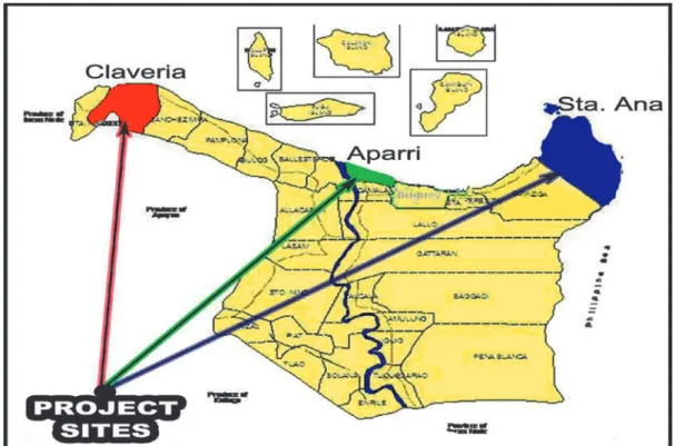
The project was located in Cagayan province, which lies approximately between latitude 18o 16’ 00” and 11O 35’ 00” North and longitude 121O 02’ 00” and 121O 14’ 30” East. Cagayan’s coastline extends for about 154 km connecting eleven (11) coastal municipalities from Sta. Praxedes on the west to Sta. Ana on the east. The prov-ince has a total area of approximately 477,550 hectares (Figure 1). Three municipalities were chosen as project sites based on accounts of the vulnerability of the area to flooding and coastal erosion presumed to have resulted from climate change. In addition, the three municipali-ties identified were seen as growth centers of the region where major economic activities were being undertaken. These sites are strategically located along Babuyan Channel, which is the most important fishing ground in the Cagayan Valley Region (BFAR R02, 2005)
Ironically, though they are found along the coastal area of Cagayan, the three municipalities have climatic conditions quite distinct from each other. Claveria belongs to type II climate that is characterized by not having a distinct dry and wet season. Generally, it is cool from November to February, with December and January being the coldest months, and warm during March to October with the hottest period from May to June.
The municipality of Aparri, on the other hand, falls under the third type of climate. Rainfall, humidity and temperature over the last five years do not follow a regular pattern that can be relied on to identify the wet-test and driest parts of the year. The town is partly shel-tered from the northeast monsoon and winds but open to the southeast monsoon and frequent storms. Rainfall is primarily brought in by typhoons and monsoon rains. Generally, it is cool during the months of November to February and warm during the months of March to October.
Sta. Ana falls under a fourth type of climate that is characterized by having an even distribution of rainfall throughout the year. The dry season begins in the month
of March and ends in late July. The hottest period of the year is the months of April to June. Generally, the weather in the months of June, July and August is mod-erate with occasional rains. The rest of the year is char-acterized by not having very pronounced seasons, and is relatively dry from November to April and wet during the rest of the year.
2) Hazard and vulnerability assessment (1) Participatory methods
The assessment team conducted a household interview, interviews with key informants, and focus group discussions. Participants were the key municipal officials, namely the Municipal Mayor, the Municipal Agriculturist, the Municipal Engineer, the Municipal Planning and Development Officer, the Municipal Environment Officer, the Municipal Disaster Coordinator, the Assessor’s Office, fisherfolk leaders, Barangay Councils, health workers and different associa-tions. Methods used included structured participatory learning exercises (SLE, lecture-discussions, workshop, group discussion, project site visits).
Other activities conducted were environmental scanning and bio-physical observations to assess the area, a review of related literature and the gathering of secondary data. Respondents for the household survey
were randomly selected using a structured questionnaire. Spot maps and hazard maps were prepared by the com-munity during the focus group discussion. Flooded and inundated areas in the barangay were identified by the participants.
(2) Participatory identification of climate change planned adaptation strategies:
Identification of climate change adaptation options were made through focus group discussions (FGD) joined by the Barangay Council, fisherfolk leaders, and a women’s group. This type of discussion was con-ducted in six identified barangays. The same process was done with the Local Government Unit key officials. The results were validated in the community during the household survey.
(3) Cost effectiveness analysis
The planned adaptation strategies were subjected to a viability test using the following criteria: 1) financing; 2) effectiveness of the options; 3) manpower; 4) urgency; 5) social acceptability; 6) capability to respond to mul-tiple goals; 7) efficiency and 8) technical support. This was followed by an actual survey of the areas that will be affected by the adaptation strategies. Secondary data were also gathered from the different agencies
(4) Household survey
Before the conduct of the survey, the number of household respondents was computed and each house-hold involved was selected randomly with an interval of five household per purok. The sampling allocation/distri-bution of respondents is shown in table 7.
1) Result and discussion
1) Households in Coastal Communities and Climate Change
The majority of respondents in the six study sites were sons or daughters of the households (43,2%) of which about 21% were the heads themselves and 16% were their spouses. The rest were the other members of their family. Male respondents comprised 51 % of the population and female 49%. Around 51% were single and 49% married (table 2). Their average years of schooling were only about six years, which meant that most respondents had only finished elementary education. The majority of respondents belonged to the farming and fishing group except perhaps in the munici-pality of Palawig, where 54% of the respondents were employed.
1) Climate Hazards Households Face
Flooding has been a perennial problem in Cagayan usually brought about by the swelling of the Cagayan river. From 2001 to 2011 (table 3), there had been 16 reported cases of flooding incidents in the area with two causing inundation of houses and farmlands. The identi-fied cause was heavy rains coupled with typhoons that caused flooding in 2006 and was repeated in 2010. The latest flooding incident occurred in 2011, causing a flood depth that ranged from 0.3 feet to one meter. The resil-iency of areas to flooding made recovery relatively easy for affected families. It usually took an average of three days for household to be submerged under floodwaters, a
Town Barangay No. of HHs Coastal HHs Final HH % Sample size
APARRI Punta 1,005 1,005 839 31% 94
Padaya 872 777 673 25% 75
CLAVERIA Pata East 245 245 245 9% 27
Taggat Norte 269 269 211 8% 24
STA.ANA Palawig 423 371 255 10% 29
San Vicente 852 602 461 17% 52
TOTAL 3,666 3,269 2,684 100% 300
day to recover from the economic distress and two days to return to a normal situation.
2) Community based and participatory vulnerability assessment
Using the vulnerability matrix that looked into the effects of the identified hazards on the community and the adaptive capacities at the household and barangay level, four of the most sensitive areas were considered. These were the residential houses that got flooded, the fisheries, agriculture and the livelihood of the people living in the area. The results showed that the most vul-nerable part of the society is the households living along a river system and its tributaries. Flooding in low-lying barangays brought economic distress and in worst sce-nario took the lives of people. But because of years of flooding experience, the region has become adapted and resilient to the situation.
(1) Barangay Paddaya, Aparri
The Barangay of Paddaya experienced the most devastating effects of climate change out of the 6 baran-gays identified. Almost 50 % of the Puroks had been submerged in almost all typhoons that bring along a great volume of water. Flooding is experienced in the barangay in almost all cases where heavy rains are involved. The creek traversing the barangay serves as the passageway of floodwaters coming from the main river, the Cagayan river. The most affected are the resi-dents, who need to be evacuated every time. Livelihood is also affected because the fishermen cannot go out to fish. Agricultural areas are also flooded. Residential houses are frequently damaged and roofing blown away by the wind. The perennial occurrences of such calami-ties forced the affected to shift from fishing to farming and they learned to change their varieties of their plant to more flood resistant ones.
Climate Change Adaptation (CCA) options (table 4) at the barangay level include establishment of a flood-gate to control the flow of floodwaters. The flood-gates should Table 1. Household Sampling.
Particulars Pad Pun Pal S V PE TN Total Mean Relationship to HH Head 20 20 20 22 25 107 21.40 Spouse 16 16 20 17 18 14 101 16.83 Child 50 46 18 48 49 48 259 43.17 S & D in laws 1 2 43 1 3 3 53 8.83 Grand S &D 6 8 3 4 6 4 31 5.17 Father/Mother 2 2 4 1 1 2 12 2.00 Other relatives 5 6 4 7 2 3 27 4.50 Helpers 8 2 4 14 4.67 Gender Male 52 51 52 51 52 48 306 51 Female 48 49 48 49 48 52 294 49 Marital Status Married 34 37 57 42 34 204 40.8 Single 56 56 35 52 56 255 51 Widow 5 3 8 2 4 22 4.4 Live-in/divorce 5 4 4 6 19 3.8 Education (yrs) 6 6.5 6 8 5 8 107 21.40 Occupation Govt officials 2 4 54 3 1 5 69 11.50 Professionals 1 1 3 1 12 3 21 3.50 Technicians 1 1 1 1 1 3 8 1.33 Clerical 1 1 2 1 1 6 1.20 Bns/bhw 2 2 1 1 3 9 1.80 Farmers/fishers 22 12 2 19 19 19 93 15.50 Traders 1 2 22 3 1 2 31 5.17 Plant/machine opr 1 5 3 1 1 2 13 2.17 Laborers 2 7 6 4 1 6 26 4.33 Spe occupation 1 1 3 1 2 8 1.60 Vendor 2 4 6 4 1 4 21 3.50 Others occ 64 60 61 60 50 295 59.00
Flooding Pad Pun Pal SV PE TN total Mean
Climate Hazard HH face
No flood from 2001-2011 17 19 13 10 16 14 79 15.8
No flood inundated 2 3 2 1 3 1 11 2.2
Cause
Heavy rain (%) 6 6 79 91 30.3
heavy rains + typhoon (%)) 83 48 100 21 204 68.0
heavy rains + typhoon +HT (%) 4 38 4 4
heavy rains + typhoon +SS (%) 2 7 2 2
Table 2. Demographic profile of respondents of the six barangays.
Table 3. Cause and incidents of flooding in the six target barangays (% response). Legend: Pad – Paddaya; Pun – Punta; Pal – Palawig, SV – San Vicente, PE –Pata East, TN – Taggat Norte
also be widened to allow a greater volume of water to flow. Some members of the barangay council suggested dredging to de-silt the creek. The establishment of a sea-wall was also suggested as they have observed that the shore is coming closer to the barangay proper.
A two-storey evacuation building was also pro-posed, together with a rescue boat. The planting of coconut trees along the riverbanks and foreshore areas to serve as wind breaks in the times of typhoons was also suggested. Saltwater intrusion was also experienced
particularly during the summer time in some areas of the barangay particularly in Sitio Simay (which, however, is not within the one km coastal area under study). To cope with this situation however, the people buy mineral water for drinking or harvest rainwater. The provision of a water filtration system is suggested to make rainwater potable for household use.
(2) Barangay Punta, Aparri
The residents of the barangay have to pile up sand bags to prevent the water from entering into their houses. At times of worst flooding the gymnasium serves as the evacuation area of the barangay residents. Problems related to livelihood are for the meantime being addressed by the mining activity along the river.
CCA options in the barangay level include dredging the Cagayan river to deepen and carry more water. The river has been silted due to runoffs that bring along silt and other debris to the river. Floodwalls and seawalls were also suggested to arrest further erosion of the river
and prevent intrusion of water into the main part of the barangay.
CCA options (table 5) during typhoons included provision of a public address system (megaphone) deemed necessary to help disseminate timely information to constituents. Installation of an early warning system and distribution of relief goods were also suggested. Household options were mostly concerned with making the affected houses resilient, relocating frequently flooded houses and digging canals.
(3) Barangay Palawig, Sta. Ana, Cagayan
Two types of climate change phenomena were experienced in barangay Palawig: flooding and coastal erosion. The barangay is traversed by the Palawig River, which overflows due to heavy downpour. In addition, the storm surge had caused flooding affecting 40 % of the residents (around 71 households) living along the river-banks and along the coast. Those areas found to be most affected by the flooding were the residents themselves,
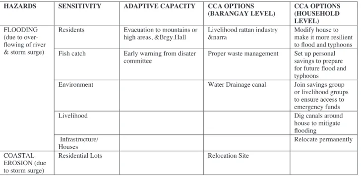
HAZARDS SENSITIVITY ADAPTIVE CAPACITY CCA OPTIONS
(BARANGAY LEVEL) CCA OPTIONS (HOUSEHOLD LEVEL) FLOOD ING Residents Piling of sand bags Dredging along Cagayan
River Modify house to make it resilient to flood and typhoons; Fish Catch Distribution of relief goods Construction of Flood wall/
Sea Wall Relocate perma-nently, Infrastructure/
Houses Evacuation to the gymna-sium Construction of river control Dig canals around the house
Water Source Participate in
com-munity activities;
Environment Join group
sav-ings or livelihood to ensure access to emergency funds Table 4. Vulnerability Matrix of Barangay Paddaya, Aparri.
Table5. Vulnerability Matrix of Barangay Punta, Aparri.
HAZARDS SENSITIVITY ADAPTIVE CAPACITY CCA OPTIONS
(BARANGAY LEVEL) CCA OPTIONS (HOUSEHOLD LEVEL) FLOODING Residents Evacuation to the Paddaya
Elementary School Construction of Flood Gate, Widening of Bridge, & De-Silting
Improvement of houses to become resilient
Early Warning Information
of the Brgy. Councils 2-storey Evacuation Center Fishing Shifting from fishing to
farming Rescue Boat
Crops Changing of Seed Variety
for farming replanting of dam-aged crops
Livelihood Additional source of
Table 6. Vulnerability Matrix of Barangay Palawig, Sta Ana. their livelihoods, fish productivity, and the environment.
In the face of these hazards, people found installa-tion of an early warning system and moving to higher ground as doable options in the absence of a more advanced or comprehensive coping strategy. On the barangay level, the provision of livelihoods such as rattan processing was deemed important (table 6).
Accumulation of wastes and the absence of a good drainage system should also be addressed to minimize the adverse effects of flooding. Of equal importance is the provision of a more efficient early warning system that will provide notice to the people on the occurrence of calamities. Provision of transport facilities and a good evacuation facility are also proposed.
Soil erosion had been experienced along zone 5. Areas affected include residential lots that became closer to the sea. The barangay has proposed relocation of the residents to a safer area.
(4) Barangay San Vicente, Sta Ana
San Vicente, located in the northeastern part of the province, is the entrance and sometimes an exit point for typhoons and other calamities that hit the Philippine archipelago. It is also one of the areas influenced by the Kuroshio Current. The current brings productive water supporting the natural resources of the area. Some areas of the barangay are very vulnerable to flooding during strong typhoons bringing heavy rains because of the lack of a drainage canal that is supposed to let out the
flood-waters. Those affected are 71 households along Sitio Pasigit, Sitio Alpha and Sitio Pacak. The most sensitive part of the community is the residential area. Household structures are damaged due to strong winds. House roofing is sometimes blown by the strong wind. Fish sup-plies decline because fishermen cannot go out to fish, and thus the livelihood of the people living in the barangay is also affected.
The barangay was able to adapt to the situation by making sure affected families would have a place to stay in time of calamities. Evacuation centers were made available. The barangay officials also ensured that the residents were forewarned of the coming calamities. The tsunami incident in Japan served as a wakeup call to the residents such that people became wary of earthquakes. Training on tsunami preparedness was then conducted by the LGU to educate the residents on what to do in the case such an incident happens again (Table 7).
Relief goods were also given to the people. The barangay officials were aware of the importance of the forest in mitigating the adverse effects of climate change. They knew they would have to plant more trees to mini-mize flooding thus a greening project was one of their priority programs.
On the barangay level, waste management was seen as a major concern. With the rapid industrialization of Sta Ana, the accumulation of domestic and industrial waste was becoming a problem. Waste treatment facili-ties were provided by business establishments, however, waste segregation was not carried out by a majority of
HAZARDS SENSITIVITY ADAPTIVE CAPACITY CCA OPTIONS
(BARANGAY LEVEL) CCA OPTIONS (HOUSEHOLD LEVEL) FLOODING
(due to over-flowing of river & storm surge)
Residents Evacuation to mountains or
high areas, &Brgy.Hall Livelihood rattan industry &narra Modify house to make it more resilient to flood and typhoons Fish catch Early warning from disater
committee Proper waste management Set up personal savings to prepare for future flood and typhoons
Environment Water Drainage canal Join savings group
or livelihood groups to ensure access to emergency funds
Livelihood Dig canals around
house to mitigate flooding Infrastructure/
Houses Relocate permanently
COASTAL EROSION (due to storm surge)
residents at the household level. In a joint coastal moni-toring project conducted by the LGU and the BFAR in the year 2009, the presence of garbage thrown in the ocean by people living in the area was said to cause coral die off. The matter needs to be given attention since it will affect the adaptive capacity of the area against flooding and other climate change phenomena. Fish productivity will be affected since non-biodegradable plastics will cover the coral areas and other biophysical resources and consequently will affect the livelihood of the people in the area.
Provision of livelihood emerged as a CCA option to mitigate climate change effects. Possible livelihoods in the Barangay are work with shellfish handicrafts and seaweed production. Also, charcoal ‘uling’ making is prevalent because of the province’s productive mangrove areas. The people are aware of its negative impacts but still continue to exploit the resources because of the prevailing poverty in the area, hence a need to intensify information dissemination on this problem is suggested. Based on the above premises, provision of livelihood can be both a result of climate change and also a response to the phenomena noted above. The incapacity of the fish-ermen to earn a living should be equally answered to be able to cope with the flood hazard.
On the household level, making their houses resil-ient to typhoons is enough to survive calamities along with permanent relocation from areas always submerged by water. The householders also found digging canals around their homes to be a solution for easing the damage caused by flood waters. Saving for the future was also suggested for them to survive said calamities.
HAZARDS SENSITIVITY ADAPTIVE CAPACITY CCA OPTIONS
(BARANGAY LEVEL) CCA OPTIONS (HOUSEHOLD LEVEL) FLOODING
(due to heavy rain)
Residents Construction of evacuation
center Waste management Modify house to make it resilient to flood and typhoons; Fish production Early Warning information
of the brgy. councils Early warning devices (internet connection) Relocate perma-nently, Livelihood Training on tsunami alert Alternative livelihood
(handicrafts & seaweeds) Dig canals around the house to mitigate flooding,
Infrastructure/
Houses Relief goods & medicine subsidy Set up personal savings to prepare for future flood and typhoon
Environment Greening program (man-grove reforestation)
(5) Barangay Pata East, Claveria
Flooding mostly affects the residential areas in this barangay. While the fish catch was also observed to decrease over time, the livelihoods of the people were also affected. Waste disposal was also seen as a problem in the community. Waste disposal is a problem not only in Pata barangay but also in most barangays of Claveria due to insufficient landfills.
In times of flooding the immediate solution of the barangay is to bring the people to a safer place which most of the time is the elementary school in the barangay or the lighthouse that is located atop a mountain. The latter also served as an evacuation center of the barangay and other coastal barangays of Claveria during a tsunami alert in 2010 (table 8). Relief goods were also given to the affected families.
With this hazard the barangay finds it necessary to construct dikes and improve their drainage system to minimize flooding. They also have felt the need to pro-vide alternative livelihoods and protect the coastal area through the planting of mangrove propagules. With the assistance of the BFAR and the DENR, the latter is now being addressed.
(6) Barangay Taggat Norte, Claveria
The barangay was able to manage flooding by giving early warning and evacuating the affected resi-dents. Due to the problem of waste management, the people had initiated a coastal cleanup to ease the flooding incidents.
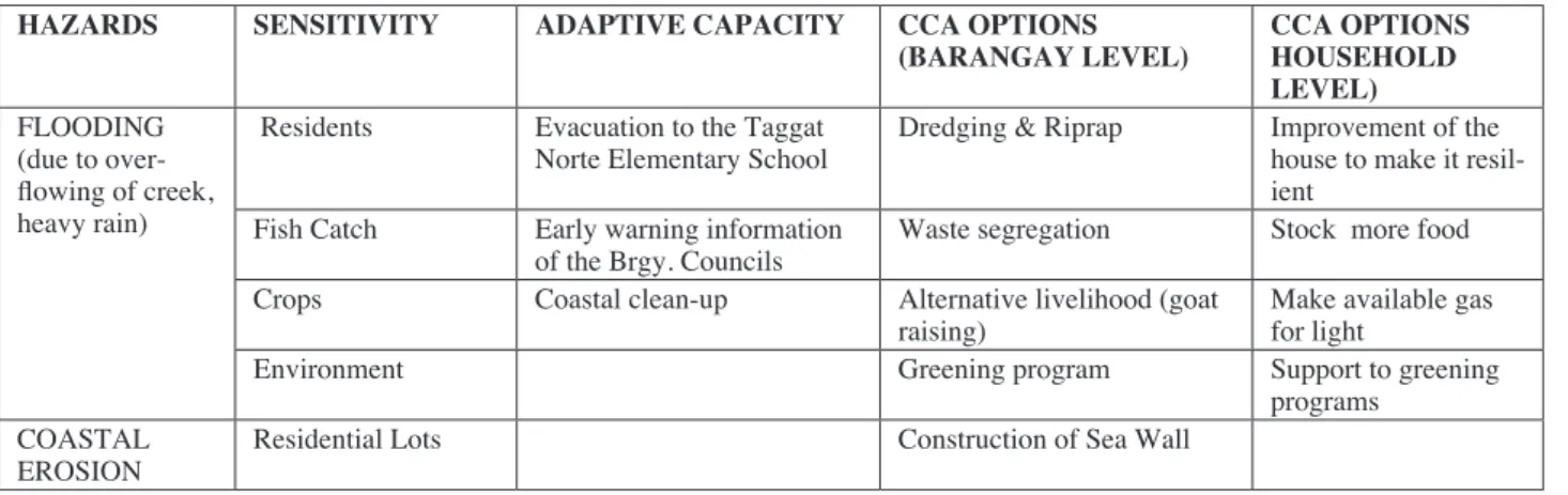
CCA options (table 9) identified at the barangay level are riprapping the sides of the creek and dredging to Table 7. Vulnerability Matrix of Barangay San Vicente, Sta. Ana.
Table 8. Vulnerability Matrix of Barangay Pata East, Claveria
Table 9. Vulnerability Matrix of Barangay Taggat Norte, Claveria
HAZARDS SENSITIVITY ADAPTIVE CAPACITY CCA OPTIONS
(BARANGAY LEVEL) CCA OPTIONS (HOUSEHOLD LEVEL) FLOOD (due to
heavy rain) Residents Evacuation to the Pata Elementary School Construction of dike Improvement to make house resilient to flooding
Fish Catch Early Warning Information
of the Brgy. Councils Livelihood program Dig canals Livelihood Distribution of relief Goods Construction of drainage
canal Reinforced ponds/fish cages/animal pens
Environment Upland and mangrove
refor-estation Support and assis-tance to refo efforts allow a good flow of water. Waste segregation was also
suggested because the residents believe that the strewn wastes affect the productivity of their coastal area. They also have identified provision of livelihood, especially in times where fishing is not possible. Greening and mangrove reforestation were also suggested in order to improve the productivity of resources and as a protection against strong storm surges and wave action.
Erosion is experienced along the shoreline such that the sea is now becoming nearer and the seabed, steeper. Construction of a seawall was suggested to ease the problem. Household options are on making their houses resilient, stocking food and having enough gas for their lights.
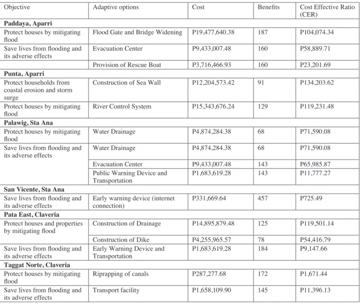
3) Cost-effectiveness analysis of planned adaptation options
The CER offers a clear metric that the community and agencies can use in picking their top choice from among the identified climate change mitigation options. The CER depends on the average number of household beneficiaries and average investment costs for ten years. Two major objectives were considered, that is, to protect
households from flooding and save lives. From the iden-tified options, only two or three were analyzed (table 10). The costs were based on the computation provided by the engineering section of the LGU and BFAR while the benefits were for the number of people currently living in the area. From the options, we can see that infrastruc-ture projects (flood gate and bridge widening in Paddaya, Aparri - P19,477,640.38) had the highest cost while provision of an early warning device in San Vicente the lowest except for the riprapping of the canal in Taggat Norte which was valued at P287,277.68
Ranking all adaptation options identified by the community and taking into consideration the number of households saved and the CER (table 10), provision of an early warning device (San Vicente, Pata East &Palawig) is still the most cost effective adaptation strategy, fol-lowed by riprapping of canals (Taggat Norte), provision of a multi-purpose vehicle (Taggat Norte), provision of rescue boats (Paddaya), construction of an evacuation center (Paddaya and Palawig), construction of flood gates (Paddaya) and construction of dikes and canals (Pata East).
HAZARDS SENSITIVITY ADAPTIVE CAPACITY CCA OPTIONS
(BARANGAY LEVEL) CCA OPTIONS HOUSEHOLD LEVEL) FLOODING
(due to over-flowing of creek, heavy rain)
Residents Evacuation to the Taggat
Norte Elementary School Dredging & Riprap Improvement of the house to make it resil-ient
Fish Catch Early warning information
of the Brgy. Councils Waste segregation Stock more food Crops Coastal clean-up Alternative livelihood (goat
raising) Make available gas for light
Environment Greening program Support to greening
programs COASTAL
4) Awareness of Climate Change and Levels of Disaster Preparedness
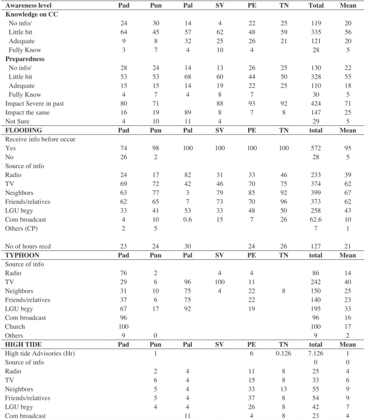
Awareness level in regard to the knowledge of respondents showed that around 56% have a bit of knowledge of the phenomena and around 20% have no knowledge of it at all. With this, those who have knowl-edge are also more prepared for what will happen in case calamities occur. The impacts have been severe in the past but because of efforts conducted by the LGU and NGAs negative impacts have been mitigated. Sources of information are neighbors, friends and television. In general, warnings of typhoons are received at an average of 21 hours before and one hour before for both the flooding and high tide. Due to this, when flooding and high tide occur, affected families have very little time to evacuate immediately. This happens in almost all baran-gays affected by the said phenomena.
5) Institutional Context of Climate Change Adaptation Strategies
Saving lives and properties are the primary con-cern of the LGUs. The training and advocacy campaign related to climate change has been very useful to their decision making. Some LGUs have already incorporated construction of basic infrastructure to mitigate flooding and soil erosion such as in barangay Punta in Aparri.
The provision of livelihood was also seen as a crucial factor that will help alleviate the plight of the community in times of extreme climate change. For all of the identified adaptation options, the role of the LGU is of utmost importance since implementation is depen-dent upon the LGU’s support. Of equal importance is the assistance of other line agencies in region 02 that are members of the Regional Disaster Risk Reduction and Management Council (RDRRMC). The LGU will
Objective Adaptive options Cost Benefits Cost Effective Ratio
(CER) Paddaya, Aparri
Protect houses by mitigating
flood Flood Gate and Bridge Widening P19,477,640.38 187 P104,074.34
Save lives from flooding and
its adverse effects Evacuation Center P9,433,007.48 160 P58,889.71
Provision of Rescue Boat P3,716,466.93 160 P23,201.69 Punta, Aparri
Protect households from coastal erosion and storm surge
Construction of Sea Wall P12,204,573.42 91 P134,203.62 Protect houses by mitigating
flood River Control System P15,343,676.24 129 P119,231.48
Palawig, Sta Ana
Protect houses by mitigating
flood Water Drainage P4,874,284.38 68 P71,590.08
Save lives from flooding and
its adverse effects Water Drainage P4,874,284.38 68 P71,590.08
Evacuation Center P9,433,007.48 143 P65,985.87
Public Warning Device and
Transportation P1,683,619.28 143 P11,777.27
San Vicente, Sta Ana Save lives from flooding and
its adverse effects Early warning device (internet connection) P331,669.64 457 P725.49 Pata East, Claveria
Protect houses and properties
by mitigating flood Construction of Drainage P14,895,879.48 125 P119,501.14
Construction of Dike P4,255,965.57 78 P54,416.79
Save lives from flooding and
its adverse effects Early Warning Device and Transportation P1,683,619.28 184 P9,147.66 Taggat Norte, Claveria
Protect houses by mitigating
flood Riprapping of canals P287,277.68 172 P1,671.44
Save lives from flooding and
its adverse effects Transport facility P1,658,109.90 145 P11,396.13
Table 11. Awareness level of respondents on climate change phenomena (% response) be able respond to climate change events with proper
funding, strong political will and the strong cooperation of the community.
Financial assistance was also seen as a major con-straint in the implementation of the planned adaptation option to mitigate the adverse impacts of climate change.
This is exacerbated by the following: the lack of pre-paredness of the community; the absence of alternative livelihood in times of calamity; poorly built housing or shelters; the fact that some houses are built in low lying or coastal areas; general poverty in the area; environ-mental degradation due to human and economic
inter-Awareness level Pad Pun Pal SV PE TN Total Mean
Knowledge on CC No info/ 24 30 14 4 22 25 119 20 Little bit 64 45 57 62 48 59 335 56 Adequate 9 8 32 25 26 21 121 20 Fully Know 3 7 4 10 4 28 5 Preparedness No info/ 28 24 14 13 26 25 130 22 Little bit 53 53 68 60 44 50 328 55 Adequate 15 15 14 19 22 25 110 18 Fully Know 4 7 4 8 7 30 5
Impact Severe in past 80 71 88 93 92 424 71
Impact the same 16 19 89 8 7 8 147 25
Not Sure 4 10 11 4 29 5
FLOODING Pad Pun Pal SV PE TN total Mean
Receive info before occur
Yes 74 98 100 100 100 100 572 95 No 26 2 28 5 Source of info Radio 24 17 82 31 33 46 233 39 TV 69 72 42 46 70 75 374 62 Neighbors 63 77 3 79 85 92 399 67 Friends/relatives 62 65 7 73 70 96 373 62 LGU brgy 33 41 53 33 48 50 258 43 Com broadcast 4 10 0.6 15 7 26 62.6 10 Others (CP) 2 5 7 1 No of hours recd 23 24 30 24 26 127 21
TYPHOON Pad Pun Pal SV PE TN total Mean
Source of info Radio 76 2 4 4 86 14 TV 29 6 96 100 11 242 40 Neighbors 31 10 75 4 22 8 150 25 Friends/relatives 37 6 75 22 140 23 LGU brgy 67 17 92 19 195 33 Com broadcast 96 96 16 Church 100 100 17 Others 9 0 9 2
HIGH TIDE Pad Pun Pal SV PE TN total Mean
High tide Advisories (Hr) 1 6 0.126 7.126 1
Source of info 0 0 Radio 2 4 11 8 25 4 TV 6 4 15 8 33 6 Neighbors 5 4 33 13 55 9 Friends/relatives 5 4 37 8 54 9 LGU brgy 4 4 26 8 42 7 Com broadcast 11 4 8 23 4
Successive flooding and typhoons Rank Distribution of relief goods, 2 Rescue and emergency assistance 1
Community evacuation 3
Permanent relocation 6
Build early warning system 4
Replanting mangrove forest 4
Solid waste management 5
Training
Cleaning of canals 6
Marine protected area/fish sanctuary
Coastal clean up 5
priority interventions Rank
Community evacuation 2
Rescue and emergency assistance 7
Permanent relocation 9
Relief operation 6
Disaster preparedness trng 10
Early warning system 8
Financial assistance 1
Strengthened infra 4
Early warning system 3
Clean water ways 5
vention such as in mining and insufficient landfills for household wastes.
6) Household Awareness of Climate Change and Levels of Disaster Preparedness
Awareness level of respondents (table 11) showed that more or less the community has a bit of knowl-edge regarding the phenomena but around 20% have no knowledge at all. Those who have knowledge are more prepared for what will happen in case calamities occur. The impacts have been severe in the past but because of efforts conducted by the LGU and NGAs negative impacts have been mitigated. Sources of information are neighbors, friends and TV. In general, warnings on typhoons are received at a mean of 21 hours and an hour for both flooding and high tide. Because of this, when flooding and high tides occur, affected families have very little time to evacuate immediately. This happens in almost all barangays affected by the said phenomena.
7) Knowledge on local government programs on cli-mate change
The government through the RDMMC has been implementing programs to mitigate the adverse effects
of climate change and different agencies have their own roles to play. The agriculture sector, for example, has been developing flood resistant varieties of rice. The DSWD provides relief goods and is responsible for the evacuation of affected families.
Survey results revealed that rescue and emergency assistance to save lives and properties is still the most important priority of the people. The communities are also aware of the importance of mangroves, marine sanctuaries and maintenance of the cleanliness of the community in mitigating adverse consequences of cli-mate change. Top among their priority interventions are financial assistance, community evacuation and an early warning system
Conclusions
The impacts of climate change vary from one loca-tion to the other and the capacity of the community to respond to such change depends on the capability of the people to adapt and the support of the LGU and other organizations to implement mitigating measures. Ironically, the region’s geographic location and the dynamic climatic condition of the area being located at the tip of the archipelago and serving as a gateway for typhoons makes the coastal community vulnerable but resilient to climate change. Three types of weather con-ditions are experienced in the region. The northwestern part which is the location of Claveria, one of the project sites, belongs to type II, Aparri located at the middle portion falls under the third type of climate and Sta.Ana located at northeastern part experiences the fourth type of weather conditions. Flooding was identified as the most potent climate change outcome affecting the lives of the people in the coastal communities of Cagayan. Saltwater intrusion and erosion were also experienced in some areas but as these factors were not attributed to cli-mate change, people in the communities gave them only a limited amount of attention.
The vulnerability of the six barangays included in the study points to the swelling of the river system of both the main river, the Cagayan, and its tributaries when heavy rains are experienced in the uplands during typhoons and storm surge that cause flooding. The con-tribution of various factors such as forest denudation, mining and human inflicted factors like the lack of dis-cipline in regard to waste disposal on the environment have a direct bearing on the capacity of flooding to bring damage to the various communities. Through years of experience of frequent flooding occurrences, the impact on lives has been minimal but the impact on the economy Table 12. Priority ranking of adaptation strategies in times
still needs to be considered. Moreover, the communities have become accustomed to such climate hazards but are in agreement that some things should be done to address them,
Proactive adaptation capacity of the community ranges from the simplest ways to making their houses resilient and stronger against typhoons, stocking enough food and having light, to a more complex actions such as establishing seawalls and a river control system so as to address the calamity. Issues of waste management and sources of livelihood in times of calamity emerged as adaptation options. However, the mitigating measures need to be given priority in order to realize long term beneficial effects. In almost all the barangays this issue was brought up and thus needs to be addressed.
Identified climate change adaptation options of the communities geared towards mitigating the effects of flooding and specifically aiming to protect and save households in times of calamity included flood gates, the widening of bridges, an evacuation center, the provision of rescue boats (Paddaya), a seawall and a river con-trol system (Punta), dike and drainage canals, an early warning device and transport facility (Pata East), creek riprap and provision of a multi-transport facility (Taggat), an early warning system (san Vicente), a water drainage and evacuation center and the provision of a transport facility (Palawig).
The effect sof salt water intrusion and soil erosion were not considered as the communities perceived them as natural occurring incidents and more importance was placed on what was considered the greater climate hazard, which was flooding. Dredging the river also was identified but was not included in the selected options because of its impracticality and complexity accompa-nied by the cost required to implement such an option.
Cost effective adaptation options recommended for consideration were those that would benefit the greatest number of people and which would provide immediate solutions to flooding. Results shows that early warning devices posed greater effectiveness in protecting and saving households against inundation. An evacuation center also will address the need to immediately bring people to safe areas and can be well complimented by
rescue boats.
In areas where soil erosion is experienced and the proximity of the sea to the household is becoming apparent, more complex infrastructure, though expen-sive, can in the long run be cost effective and could save lives and households. Examples are the river control in Punta barangay, floodgate in Paddaya barangay, and water drainage in barangays Palawig and Pata East. These adaptation options are perceived as lowering the risks of damage that can be afflicted by climate change in the community.
References
BFAR RO2, Infrastructure Project Proposals DOST R02, Project Brief and Proposals
Garcia, Arnel 2010. DSWD RO2. “Comprehensive Disaster Recovery Program for the Cagayan Valley Region : A Strategy”. Paper presented during RDC meeting.
LGU Aparri, BFAR and DENR. 2008. Municipal Coastal Environment Profile. Draft doc.
LGU Claveria, BFAR and DENR. 2008. Municipal Coastal Environment Profile.
LGU Sta Ana, BFAR and DENR. 2008. Municipal Coastal Environment Profile. Draft doc.
NEDA, 2009.Cagayan Valley Regional Action Agenda for Productivity and Quality.National Economic and Development Authority.Tuguegarao City. NEDA, 1991. Regiona Physical Framework plan.
National Economic and Development Authority. Tuguegarao City.
LGU Aparri, BFAR and DENR. 2008. Municipal Coastal Environment Profile. Draft doc.
Paddaya Barangay Profile. 2011.
RDC 02 –NEDA, 2005. Cagayan Riverine Zone Development Framework Plan 2005 – 2030. National Economic and Development Authority. Tuguegarao City.
RDC 02 –NEDA, 1992. Regional Land Use Plan. National Economic and Development Authority. Tuguegarao City.