using Cloud Computing Type Virtual Reality and Case Study
著者 Zhenhan Lei, Shunta Shimizu, Natuska Ota, Yuji Ito, Yuesong Zhang
journal or
publication title
International Review for Spatial Planning and Sustainable Development
volume 5
number 1
page range 15‑28
year 2017‑01‑15
URL http://hdl.handle.net/2297/46728
doi: 10.14246/irspsd.5.1_15
15
DOI: http://dx.doi.org/10.14246/irspsd.5.1_15
Copyright@SPSD Press from 2010, SPSD Press, Kanazawa
Construction of Urban Design Support System using Cloud Computing Type Virtual Reality and Case Study
Zhenhan Lei
1*, Shunta Shimizu
1, Natuska Ota
1, Yuji Ito
1and Yuesong Zhang
21 FORUM8 Co., Ltd.
2 Graduate School of Education, Yokohama National University
* Corresponding Author, Email: [email protected] Received: Jan 25, 2016; Accepted: Sept 08, 2016
Key words: Urban Planning, Urban Design Support System (UDSS), Virtual Reality (VR), Cloud-Computing type VR (Cloud-based VR)
Abstract: This paper contributes a design support system based on cloud-computing type virtual reality (cloud-based VR) for urban planning and urban design. A platform for Cloud-based VR technology, i.e. a VR-Cloud server, is used to open a VR dataset to public collaboration over the Internet. The digital attributes representing the design scheme of design concepts includes the land use zone, building regulations, urban design style, and other design details of architectural design, landscape, and traffic/architectural environment/sunshine/wheather/noise/inundation/tsunami/earthquake/evacuati on simulation. Then practice using this cloud-based VR urban design support system is categorized into three applicable case ‘types’, synchronized, distributed synchronized and distributed non-synchronized. The effect of the use of this system in urban design and in urban planning processes is evaluated.
1. INTRODUCTION
This paper contributes an urban design support system (UDSS) of cloud- computing type virtual reality (Cloud-based VR) for urban planning and urban design.
The process of urban planning and city design industries in Japan often
can be divided into a series of different phases: conceptualization, detail
formation, and support and maintenance plan formulization. During
conceptualization there are multiple components that must be considered: it
is important to examine the neighboring environment, positioning and scale,
structural design and durability, and long-term (20-30 years) goals of the
project in question. As a project moves on to its detailed formation phase,
designers start focusing on the numerous value-added features that are to be
integrated into the project. Given that the goal or contracting partner
between different phases of the project can vary, the necessity of effective
consensus building before transitioning to the next stage is apparent in order
to successfully carry out a project.
The aforementioned issue is especially true if the project in question follows the idea of participatory planning, where the locals’ or the stakeholders’ opinions need to be considered. To achieve this, numerous UDSS have long been developed. However, to ensure such UDSS continues to properly serve its purpose in-between different phases, it is important to seek ways to extend either the reasons or chances that a system can be continually used.
Shiffer (1995) proposes and categories the situation when UDSS is used into the following four categories: 1. the same-place same-timed
“synchronized communication within the same room”, 2. the same-place differently-timed “non-synchronized communication within the same room”, 3. the different-place same-timed “distributed and synchronized communication”, and 4. the different-place different-timed “distributed and non-synchronized communication”.
Virtual Reality (VR) spaces that can be navigated, as was observed in some large scale VR software such as Second Life or Active Worlds, have the potential to be used for the purpose of consensus building. The incorporation of VR into UDSS, and features such as building reconstruction or renovation design games, urban landscape design, Geographic Information Systems (GIS) or evacuation simulations, has long been a hotly researched or developed topic due to the versatility of VR environments.
Brail and Klosterman (2001) proposed a UDSS by incorporating three- dimensional computer-aided design (3D CAD) technologies to achieve effective communication between stakeholders and designers in his research.
Nagano and Takafumi (2008) once recreated a virtual environment on the internet for the purpose of surveying local residents for opinions, while publicizing all decisions and procedures of the design committee. Lorentzen, Kobayashi, and Ito (2009) attempted goods transportation inside a VR simulation. Abdelhameed (2012) proposed a VR microsimulation player to visualize the entire construction process of a building. Kawano, Morimoto, and Koike (2005) conducted surveys and examined the usefulness of 3D VR being used as a consensus building tool. Zhang et al. (2015) contributed an application mapping historic buildings based on 3D laser scanning technology. Sugihara (2015) contributed a GIS and CG integrated system that automatically generates 3D building models for UDSS. Shen and Kawakami (2007) have created a web-based application where users can easily create their own VR designs. Shen and Kawakami (2010) proposed an online urban aesthetic design and visualization application. Shen et al.
(2013) proposed a UDSS based on 3DVIA and Google Earth to support urban design. Finally, with the advent of cloud computing technologies, UDSS has now been attempting to leverage on this technology.
The fundamental concepts of cloud computing can be traced back to the mainframe computing era as early as the 1950s. Farber (2008) proposed the main advantage of cloud computing as being the elimination of the hurdle of hardware spec limitations; in theory, any user with any device would be able to access and utilize a certain application or data through the internet. Due to this, the proliferation of broadband internet and cloud computing has been a popular subject since 2007 (Grozev & Buyya, 2014).
Existing cloud computing technology research has seen increasingly
wider uses. Computer scientists of all sorts have been heavily focusing on
cloud computing technologies in the hopes of achieving sustainable
information services (Chowdhury, 2012). Further, with the proliferation of
smartphone devices, many mobile cloud services have been designed with
these users in mind (de Vries et al., 2014; Grover, 2013; Ma, Cui, &
Stojmenovic, 2012; Michael & Clarke, 2013; Ngai & Gunningberg, 2014).
Due to cloud computing’s expandability, accessibility and potential for cost- cutting, it is extremely popular also in geographical research (Guan et al., 2013; Huang et al., 2013; Marques et al., 2013). On the other hand, cloud computing easily allows big data collection while providing a service or a part of the social infrastructure (Laurila et al., 2013; Whaiduzzaman et al., 2014).
As witnessed, cloud computing allows communication between different devices with more ease and can be argued as having an unrivalled amount of potential uses, hence the popularity across various parties.
Cloud-based VR, with the development of numerous simulation features, and a more customized user interface, can also have many different uses.
Especially given the current mass market penetration of mobile devices, an era when devices are no longer bound by space, time, or performance issues, the amount of potential and efficiency of portable computing devices being used for consensus building is unimaginable. With this in mind, Fukuda et al. (2011) examined the usability of a cloud-based VR being used as an urban planning support tool under a distributed and synchronized communication situation for project discussion. Recognizing the potential of using cloud for the purpose of an online collaborative project service, Shen et al. (2014) compared existing technologies or products, such as Google Earth, 3DVIA and cloud-based VR, over technological feasibility.
Having introduced the existing research, it can be argued that cloud- based VR has the potential to bring several major changes to urban planning processes.
This paper is categorized as the following: Section 2 briefly touches on a possible method used to help accelerate cloud-based VR being used for online consensus building. Section 3 describes the fundamental components of cloud-based VR. Section 4 gives three recent case studies of how cloud- based VR has affected the urban planning and design process of respective projects. In Section 5 this paper attempts to argue what exactly has been altered during each planning phase, based on the qualitative findings taken from the three cases. And finally, we will address some of the issues that will and should be addressed in the future.
2. RESEARCH APPROACH
The research method is described here. We developed an urban planning application based on cloud-based VR technologies in 2010, with the purpose of information sharing between different phases of urban planning, and have collected several cases of use during the years since. Due to this paper’s limitations, not all the details and design content will be disclosed in this paper, but only some cases of the positive observations.
As was mentioned, we will raise three different cases that involve using a cloud-based VR urban planning support application and examine each of them carefully. The three cases are all different in category: “synchronized communication within the same room”, “distributed and synchronized communication”, and “distributed and non-synchronized communication”
Lastly, we will examine how using a cloud-based VR urban planning
support application can have either positive or negative impacts on the
process of urban planning and design.
3. THE FUNDAMENTALS OF A CLOUD-BASED VR UDSS
To aid effectively in urban planning, a UDSS should satisfy the following three fundamental characteristics: visualization of the project, information sharing between different parties, and has the means to conduct surveys to collect as many opinions as possible.
To visualize a project, we have used the 3D VR simulation software UC- win/Road
®, in conjunction with VR-Cloud
®that is capable of representing a UC-win/Road project through cloud computing, to achieve consensus building. Both are developed and are intellectual properties of Forum 8 Co., Ltd.
By replicating the project as a 3D VR environment through UC- win/Road, abstract information such as the design concept, future outlook, or impact to the neighborhood area that cannot be verbally communicated convincingly, can be represented in a much more interactive and vivid fashion. Furthermore, the software provides numerous simulation features to reproduce elements such as traffic, sunlight, wind, noise, tsunami, flooding, earthquake, or emergency evacuation, as well as the easy incorporation and visualization of numerous Building Information Modeling (BIM) and Civil Information Modeling (CIM) analysis results. Interactive multimedia features such as pop-up text, pictures or sounds can also be used.
Information sharing and opinion collection is done through the VR- Cloud
®, which allows for quick and easy accessibility of information. Such as in Figure 1, stakeholders or other users will install a client version of VR- Cloud
®and access the 3D VR data stored in the server via the internet. The VR data is then rendered by the server and streamed back to the user’s computing device; any input commands or manipulation to the VR data is then sent back to the server and immediately reflected and sent back to the user in a real-time fashion. The compression standard of the streamed VR data is done in H.263. By using this method, even thin clients that do not possess a powerful computer can view, control or edit traditionally hardware-demanding 3D VR data without needing to replace their devices, as long as there is a sufficiently stable internet environment. Through this type of cloud computing technology, real-time information sharing of BIM/CIM data has been made possible.
Figure 1. Composition of a cloud-based VR service
To further communicate between various parties, additional features such
as 3D bulletin boards or annotation are also available in VR-Cloud
®and can
be saved and archived into the cloud server to allow distributed or unsynchronized discussion. Using these features, it can be safely argued that such technologies will greatly aid in the urban planning development processes.
4. CASE STUDIES OF USING A CLOUD-BASED VR UDSS
In this section, we will examine three different cases that have made use of the type of cloud-based VR UDSS that was previously mentioned.
4.1 3D Digital City under a Distributed non- synchronized communication situation
By projecting and replicating an existing city inside a virtual setting, we seek to simulate or replicate situations such as either future prospects, potential travel spots, or road work simulations. Combined with a cloud- based VR UDSS, we attempted to achieve effective sharing of information such as simulation/analysis results, aesthetical impact, even under a distributed non-synchronized communication situation, and observed the effects of how it has aided in the collection of opinions or in the decision making process. The case dates as far back as 2011, and a portion of it is represented in Table 1, later in this section.
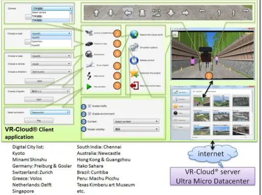
Figure 2. Composition of 3D Digital City System
The following is a description of the system’s composition and control interface.
First, clients will download and install the client version of VR-Cloud
®.
If the client uses a PC, this is done via links that can be accessed through a
web browser; if the client uses a mobile device it can be done with either a
web browser or a QR-code reader. Once completed, upon accessing the link that is relevant to the project, VR-Cloud
®will automatically activate and the 3D VR environments will be displayed. Or alternatively, upon execution of the newly installed software directly, clients will be able to connect to the contents server and can look for the project of interest. Once the VR data is properly accessed and loaded, VR-Cloud
®can then be used as a distributed and non-synchronized communication system.
Initially, users are not granted controls to the VR data. By clicking on the icon on the top-left corner, users can take control of the VR environment and freely adjust the camera to their point of interest or navigate through the VR space. Additional advanced control features are introduced in the following section and shown in Figure 2:
1) By using these arrow icons, users can interactively manipulate the camera or navigate inside. Depending on the system used, it is also possible to use keyboard and mouse directly.
2) Jump to a predefined position. This command jumps to a certain camera position that was designed by the creator for a specific reason.
3) Travel on road. This command makes travel on the road with limited control possible.
4) Drive around. This command puts users into a car which can be driven.
5) Fly on a fly path. This puts the user into flying mode that follows a predefined path.
6) Walk around. This command allows free movement inside the space with collision elements.
7) Play animation. This command allows users to see an automatic scripted event or presentation that is predetermined by the original author of the VR project. Elements such as multimedia, simulation, or text boxes/captions can be shown.
The following lists some of the elements that can be switched on or off:
1) Enable Traffic. This command enables random traffic on the road.
2) Enable environment. This command enables environmental changes such as time progression, weather effects, or wind (as well as what is affected by the wind).
3) Context. This command allows users to switch between different context and settings (such as traffic volume, environmental themes) that are predetermined by the author.
4) Model visibility. This command enables the visibility of the models, such as trees or buildings that have been placed.
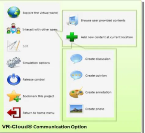
Figure 3. Communication features
To collect the voices of stakeholders, numerous communication options are also available. Such as in Figure 3, in VR-Cloud
®, it is possible to start a new discussion or view discussions started by others, as well as to upload screenshots. All changes can be viewed independent of each other, making it easy to determine who and what has been done to the project.
Using this system, the simulation of existing cities and the joint synergy between BIM/CIM data, together with the cloud, makes it possible to achieve many of the features that define a VR system while maintaining a high degree of navigation, without any limits imposed by hardware specifications. Users can freely examine elements such as traffic, tsunami, and many other situations from anywhere (see Table 1).
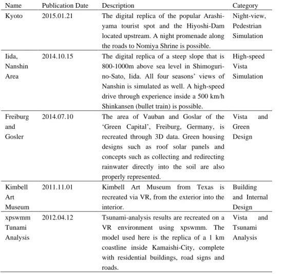
Table 1. 3D Digital City content samples that are publicly available
Name Publication Date Description Category
Kyoto 2015.01.21 The digital replica of the popular Arashi- yama tourist spot and the Hiyoshi-Dam located upstream. A night promenade along the roads to Nomiya Shrine is possible.
Night-view, Pedestrian Simulation
Iida, Nanshin Area
2014.10.15 The digital replica of a steep slope that is 800-1000m above sea level in Shimoguri- no-Sato, Iida. All four seasons’ views of Nanshin is simulated as well. A high-speed drive through experience inside a 500 km/h Shinkansen (bullet train) is possible.
High-speed Vista Simulation
Freiburg and Gosler
2014.07.10 The area of Vauban and Goslar of the
‘Green Capital’, Freiburg, Germany, is recreated through 3D data. Green housing designs such as roof solar panels and concepts such as collecting and redirecting rainwater directly into the soil are also properly represented.
Vista and Green Design
Kimbell Art Museum
2011.11.01 Kimbell Art Museum from Texas is recreated via VR, from the exterior into the interior.
Building and Internal Design xpswmm
Tunami Analysis
2012.04.12 Tsunami-analysis results are recreated on a VR environment using xpswmm. The model used here is the replica of a 1 km coastline inside Kamaishi-City, complete with residential buildings, road signs and roads.
Vista and Tsunami Analysis
All VR data had scripted events or auto-navigations created by their respective authors to aid in the understanding of the project and reduce the learning curve of having to navigate through a VR project, supposing the user is unfamiliar with the controls. The scripted events can be paused anywhere at any time and be switched to any other movements the user sees fit. The system’s great accessibility ensures all stakeholders, such as local residents, can participate online.
Looking at these distributed and non-synchronized communication use cases, it is observed that a cloud-based VR being used as a visualization and communication tool is more complete than ever. Looking from the perspective of the residents, two major effects can be observed:
1. Ease of building consensus and increase in efficiency
Users can view the project and its various elements visually from anywhere at any time while communicating between different users. The various simulation and analysis results can all be viewed at will and makes the local residents’ understanding of the project substantially easier. The drawbacks of an internet-based system, such as latency, low resolution and input lag, are remedied by placing ordinary video files of scripted events.
By having effective communication, as mentioned in the previous circumstance, residents can easily provide more accurate opinions as to what needs to be changed. However, one drawback here is that while opinions are shown as individual icons, there is currently no possible way to export them into the form of a graph or text.
2. Cost-cutting
Automatic presentation via scripted events lightens the burden on the system administrator to run, explain or maintain the data. All cases mentioned here were available 24 hours a day, with a maintenance staff doing simple checks twice a day.
Figure 4. 3D digital city data available on the official HP
4.2 Junior Urban Design Seminar under a Distributed Synchronized Communication Situation
As witnessed, using VR data to ensure effective information sharing to reach consensus has increasingly become more important.
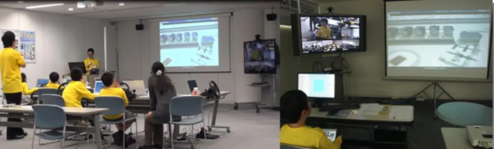
The same UDSS used in this paper is also used in the seminar “Junior Software Seminar: Let’s design a 3D VR model!”, which has been hosted since 2014. In this seminar, students from elementary to junior high school spend 1.5 days on a workshop and learn to use VR software as a form of extracurricular activity.
As seen in Figure 5, the seminar connects six different places into one via teleconferencing to transfer voice and visual data. A lecturer from Tokyo directs and teaches the students on how to create a VR urban space remotely.
Figure 5. Composition of distributed and synchronized presentation system
During the first day of the seminar, the lecturer shows to the students some basic controls and procedures on PC, which is also transferred to remote areas. Students will experience the making of roads, intersections, bridges, tunnels, trees and the positioning of building models. On the second day, students are given free control over a theme of their choice, and are free to make even exotic projects such as floating cities, or fictional race circuits.
Students then do a brief presentation of their project later in the day via the cloud server.
The presentation, as represented similarly to Figure 6, is done by having both the presenter and the audience accessing the same VR data via the cloud server. Through this, all participants look at and listen to the presenter’s manipulation of the VR data; as usual, participants that are remote to the presenter can still be connected via teleconferencing methods.
As shown in Figure 7, all VR city data remain publicized on the server as a user content case and can be accessed by clients after the seminar as well.
Notice that, however, in consideration of internet latency, instead of creating a cloud server from the PC used, it is copied to a dedicated VR data server known as the Ultra Micro Data Centre.
With a cloud-based VR, students are able to view and confirm each other’s work and borrow or share ideas with each other to further refine their own designs. Eventually, this could result in some excellent urban projects that are created by teenagers or those younger.
Left: Students in Tokyo listening to a presentation held in Osaka. Main screen shows the same VR content operated by a presenter in Osaka. Right: A presenter in Osaka presenting a
project remotely via tablet using his hands. Camera feed of Tokyo's classroom shown on the monitor next to the main screen via Web conference system.
Figure 6. Scene of presentation
This case of undistributed and synchronized communication also demonstrates how a cloud-based VR UDSS can be used as a means to effectively connect the various stakeholders or designers to achieve consensus during the design phase of a project, regardless of where. In addition, since an opinion can be reflected immediately in a synchronized situation, this automatically may translate into higher efficiency in communication.
The use of uploading information to a cloud server instead of using the
PC itself as a cloud server also greatly reduces internet latency or hardware
related video problems. However, internet speed and stability, as well as
further improvements to hardware power over time, may eventually
eliminate the need to use a dedicated server.
Figure 7. List of contents available and the main menu
4.3 Student BIM/VR Design Contest Judging system
In an urban planning and design project, it is arguably important to invite numerous experts or scholars to join the review and discussions. Upon realizing the original intents or design concepts, they would be able to objectively voice their expert opinions as well. Thus, the easier this process is the better.
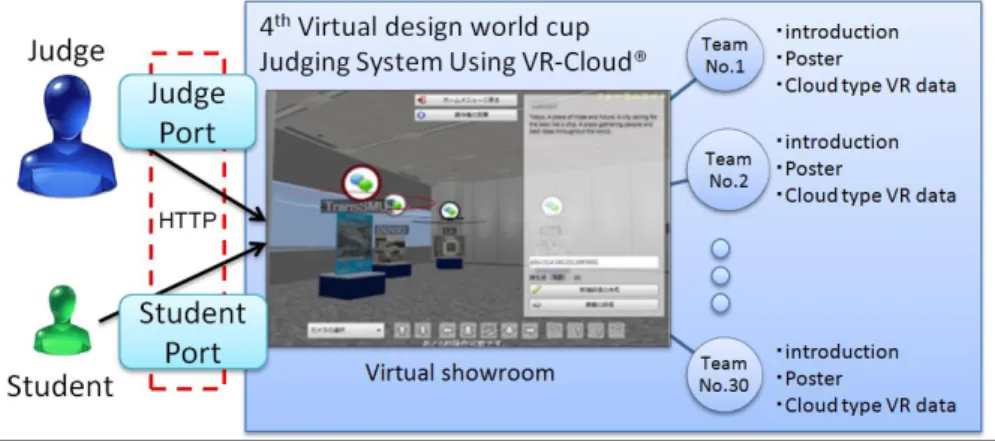
Such as in Figure 8, a similar system has been used during the fourth
“Student BIM & VR Design Contest on Cloud”, in 2014. Four regular judges as well as specially invited guest judges were to review, evaluate, and judge all projects submitted.
Figure 8. Composition of the judging system
In this design contest, students all over the world make use of BIM/CIM and VR and compete to design advanced buildings, bridges, cities or landscape data that are relevant to a pre-determined location and theme. The judges will then perform numerous simulations that are relevant to the theme of the competition and determine a winner. The final work is composed in three parts: VR data that set the script for an automatic presentation which can explain the design concept, design data that is created using design software produced by FORUM8 Co., Ltd., and the concept poster.
The following is a description of the system. As seen in Figure 8, around
30 projects are made into concept posters as well as being uploaded into a
VR exhibition space in the form of a poster object, accessible via a cloud
server. As the user navigates closer to the virtual poster object in this VR
exhibition space, all expert comments will be shown; clicking on it would
load up the cloud application, in a similar fashion to that described in
Section 4.1.
In this contest two judgement rounds are presented, one being a distributed unsynchronized communication type for all nominated projects, while a final judgement round would take place in the state of a synchronized communication within the same room.
The nomination judgment phase lasts for one week, where the four regular judges access the uploaded VR data via VR-Cloud
®installed devices using unique IDs during their free time. They would then give points to each project panel as well as their expert comments. Students on the other hand, are given a unique ID and can also access the virtual exhibition room to evaluate and provide feedback to their competing teams. Once the nomination round has closed, the top 15 teams with the most points would advance to the synchronized communication within the same room-type final judgement round.
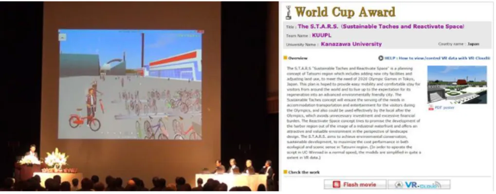
During the final judgment round, as seen in Figure 9, all entrants would undergo a defence presentation against the judges’ questions or criticisms.
All judges would share their discussion via cloud systems.
Figure 9. Final judging round and Grand Prix work published in HP after the final judging
In this case, we have witnessed both a distributed and non-synchronized communication type nomination judgement round, as well as the synchronized communication within the same room-type final round.
Participants made effective use of urban planning tools, and were evaluated against different alternative submissions to select the best project possible.
Given that the same systems have been successfully used for different categories of plan communication types, it is safe to claim that a similar system can also be used for similar situations such as during information publicizing, participatory development or public hearings.
However, to maintain fair judgement and information transparency, anonymous reviews and feedback must be considered carefully before implementation.
5. IMPACT TO THE URBAN PLANNING PROCESS DUE TO A CLOUD-BASED VR
Having examined all three cases, it is expected that a cloud-based VR UDSS can lead toward several improvements of urban planning processes.
The visualization features can greatly involve more participants than
ever; spatial, conceptual, structural or environmental information can be
more smoothly communicated to various parties to ensure that the most
reasonable opinions can or are properly reflected.
Once again, since data is accessed via a cloud computing server that can be used regardless of a user’s hardware specifications, time or location, all participants can freely participate and share information more easily and effectively, resulting in more opinions to refine the original design. This can lead to two important implications:
The first is that consensus building during the earlier concept or design phase of a project has indeed become easier with a cloud-based VR UDSS.
With a tool that effectively involves and connects more people into the project, all parties, regardless of expertise or background, can effectively communicate with each other and eliminate asymmetrical information to obtain a higher level of project understanding. Further, the involvement of local residents greatly improves the transparency and fairness, and is also worth considering.
A second conclusion is that such a UDSS greatly improves the speed, cost performance and efficiency of the urban planning industry. With information parity achieved across different parties, as well as an integrated assistance and simulation package that can be used during all phases of an urban planning process, experts of different backgrounds can effectively communicate with each other and make the necessary evaluations in a much more time-efficient and cost friendly manner. Furthermore, this also allows quicker implementation or testing of opinions from numerous parties, potentially achieving higher reliability, as well as trust.
6. CONCLUSIONS
In this research, a cutting-edge cloud-based VR urban design support system is introduced. Three different cases of this system have been examined and all three showed implications of how such a system can aid in the increase in quality, aesthetical impact, consensus and trust, reliability, transparency, efficiency and cost-effectiveness of urban planning processes.
Based on these findings, we examined how this cloud-based VR urban design support system can have considerable improvements over urban planning processes to help bring a project to a successful proposal. The contributions of this research are described in the following paragraphs.
Because the system places great demands on graphics and network speed of the server in which 3D VR data is stored, if you share your VR world to multiple users simultaneously, the fluency may be reduced, consequently spoiling the effect of consensus building. As an ideal solution, a special server should be used and a network for VR-Cloud designed to achieve seamless and fluent real-time rendering.
In the case of synchronized communication, even at times when the operator shares the same camera view of the 3D VR environment at the same angle of view with other users, the focus needs to be highlighted quickly and efficiently to attract attention from users every now and then. As part of our future development, we consider allowing the cursor moved by the operator to be viewed by other users browsing the same 3D VR environment so that the operator could spend less time describing the concept.
Because of the limitation in which only one operator can take control of
one VR data set at a time, in the case of non-synchronized communication,
several users logging into the same data at the same time may lead to a long
queue of users waiting to take control of the VR data. Hence the necessity to
support multiple inputs from multiple users.
Future prospects to refine these tool designs include elements such as further design simulation to assist in designs, a more progressive 4D VR environment that considers temporal elements, as well as the support of future wearable computing devices.
REFERENCES
Abdelhameed, W. A. (2012). "Micro-Simulation Function to Display Textual Data in Virtual Reality". International Journal of Architectural Computing, 10(2), 205-218.
Brail, R. K., & Klosterman, R. E. (2001). Planning Support Systems: Integrating Geographic Information Systems, Models, and Visualization Tools: ESRI Press, USA.
Chowdhury, G. (2012). "Building Environmentally Sustainable Information Services: A Green Is Research Agenda". Journal of the American Society for Information Science and Technology, 63(4), 633-647.
de Vries, N. J., Davel, M. H., Badenhorst, J., Basson, W. D., de Wet, F., Barnard, E., & de Waal, A. (2014). "A Smartphone-Based Asr Data Collection Tool for under-Resourced Languages". Speech Communication, 56, 119-131.
Farber, D. (2008). "The New Geek Chic: Data Centers". CNET News, 25.
Fukuda, T., Taguchi, M., Shimizu, A., & Sun, L. (2011). "Capability of a Distributed and Synchronized Discussion by Using Cloud Computing Type Vr for Townscape Design".
Journal of Architecture and Planning (Transactions of AIJ), 76(670), 2395-2401.
Grover, J. (2013). "Android Forensics: Automated Data Collection and Reporting from a Mobile Device". Digital Investigation, 10, S12-S20.
Grozev, N., & Buyya, R. (2014). "Inter‐Cloud Architectures and Application Brokering:
Taxonomy and Survey". Software: Practice and Experience, 44(3), 369-390.
Guan, H., Li, J., Zhong, L., Yongtao, Y., & Chapman, M. (2013). "Process Virtualization of Large-Scale Lidar Data in a Cloud Computing Environment". Computers & Geosciences, 60, 109-116.
Huang, Q., Yang, C., Liu, K., Xia, J., Xu, C., Li, J., . . . Li, Z. (2013). "Evaluating Open- Source Cloud Computing Solutions for Geosciences". Computers & Geosciences, 59, 41- 52.
Kawano, T., Morimoto, A., & Koike, H. (2005). "Development of Consensus Building Tool Using 3d Virtual Reality Simulation to Introduce Lrt". Proceedings of Research Meeting on Civil Engineering Planning.
Laurila, J. K., Gatica-Perez, D., Aad, I., Blom, J., Bornet, O., Do, T. M. T., . . . Miettinen, M.
(2013). "From Big Smartphone Data to Worldwide Research: The Mobile Data Challenge". Pervasive and Mobile Computing, 9(6), 752-771.
Lorentzen, T., Kobayashi, Y., & Ito, Y. (2009). "Virtual Reality for Consensus Building:
Case Studies". In Butz, A., Fisher, B., Christie, M., Krüger, A., Olivier, P., & Therón, R.
(Eds.), Smart Graphics: 10th International Symposium, Sg 2009, Salamanca, Spain, May 28-30, 2009. Proceedings (pp. 295-298). Berlin, Heidelberg: Springer Berlin Heidelberg.
Ma, X., Cui, Y., & Stojmenovic, I. (2012). "Energy Efficiency on Location Based Applications in Mobile Cloud Computing: A Survey". Procedia Computer Science, 10, 577-584.
Marques, R., Feijo, B., Breitman, K., Gomes, T., Ferracioli, L., & Lopes, H. (2013). "A Cloud Computing Based Framework for General 2d and 3d Cellular Automata Simulation". Advances in Engineering Software, 65, 78-89.
Michael, K., & Clarke, R. (2013). "Location and Tracking of Mobile Devices: Überveillance Stalks the Streets". Computer Law & Security Review, 29(3), 216-228.
Nagano, M., & Takafumi, A. (2008). "Development of Design Database System by Virtual Reality: Design Support Using Multimedia on Internet". Architectural Institute of Japan Research Report, Kyushu Branch, 3, 621-624.
Ngai, E. C.-H., & Gunningberg, P. (2014). "Quality-of-Information-Aware Data Collection for Mobile Sensor Networks". Pervasive and Mobile Computing, 11, 203-215.
Shen, Z., & Kawakami, M. (2007). "Study on Visualization of Townscape Rules Using Vrml for Public Involvement". Journal of Asian Architecture and Building Engineering, 6(1), 119-126.
Shen, Z., & Kawakami, M. (2010). "An Online Visualization Tool for Internet-Based Local Townscape Design". Computers, Environment and Urban Systems, 34(2), 104-116.
Shen, Z., Lei, Z., Li, X., & Sugihara, K. (2013). "Design Coordination Regarding Urban Design Guidelines Using Google Earth". International Review for Spatial Planning and Sustainable Development, 1(3), 53-68.
Shen, Z., Ma, Y., Sugihara, K., Lei, Z., & Shi, E. (2014). "Technical Possibilities of Cloud- Based Virtual Reality Implementing Software as a Service for Online Collaboration in Urban Planning". International Journal of Communications, Network and System Sciences, 7(11), 463-473.
Shiffer, M. J. (1995). "Multimedia Representational Aids in Urban Planning Support Systems". In Marchese, F. (Ed.), Understanding Images (pp. 77-90). New York:
Springer-Verlag.
Sugihara, K. (2015). "Automatic Generation of 3d Building Models for Sustainable Development". International Review for Spatial Planning and Sustainable Development, 3(2), 68-78.
Whaiduzzaman, M., Sookhak, M., Gani, A., & Buyya, R. (2014). "A Survey on Vehicular Cloud Computing". Journal of Network and Computer Applications, 40, 325-344.
Zhang, Y., Ying, Z., Shen, Z., Nishino, T., & Chen, X. (2015). "3d Laser Scanning Technology-Based Historic Building Mapping for Historic Preservation". International Review for Spatial Planning and Sustainable Development, 3(2), 53-67.