A Comparative Study of the Spatial Descriptions in Tourist Guidebooks
SUZUKI Koshiro
Graduate Student, Department of Geography, Tokyo Metropolitan University , Hachioji, Tokyo 192-0397, Japan Abstract: This study makes comparison of spatial descriptions for navigation between Japan and America from cross-cultural and geographic perspectives , based on 24 tourist guidebooks of four cities in Japan (Kyoto, Tokyo) and the U.S (Boston, New York City). The contents of maps and linguistic information in the guides were quantified and then analyzed . The results indicate that Japanese guidebooks use predominately visual information such as maps, while American guides mainly use linguistic information . Therefore, we can insist that there is a complementary relationship between these modes of spatial information vehicle , language and imagery. The results also demonstrate that a relative frame of reference with landmarks is the most fundamental sentence construction for giving directions . In principle, linguistic informa tion can be used to complement the lack of visual information in describing a given geographic environment, so its use rate increased in relatively unfamiliar environments . However, the contents varied with the environmental characteristics such as the regularity of street pattern . Difference in address systems between two countries also affected the way of sorting the sites style of maps, and the use frequency rate of linguistic information . ,
Key words: tourist guidebooks, wayfinding , spatial information transmission, cross-cultural comparison, Japan and USA
Introduction
Communication and mapping abilities
The sources of spatial cognition are divided into direct contact with the physical environ ment (e.g., travel behavior) and indirect one (e.g., map), The latter source contains language and visual information. Concerning the rela tionship between language and spatial cogni tion, researchers in linguistics and related fields have argued about the reliability of the Sapir Whorf hypothesis. According to this hypothe sis, spatial cognition is affected by the structure of the language used (Imai 2000). Likewise for spatial cognition research, to discuss spatial ability it is important to verify whether there is a cultural difference in cartographic communi cation mediated by maps. This question has been argued mainly about mapping abilities.
Downs and Liben (1991) reported that even university students could not grasp Euclidean relationship or shadow projections, which are considered fundamental mapping abilities, and they pointed out the importance of educating
students in the use of maps. But their argument based on constructivist view of Jean Piaget was criticized by nativists, James Blaut, who substi tuted the ontogenesis level of human develop ment for the phylogenesis one.l
The focus of the argument about mapping abilities has remained at the ontogenesis level (Blaut 1997; Downs and Liben 1997). However, the map and language are both important means of spatial information transmission, and they cannot be adequately produced by an indi vidual who is isolated from the social context . Therefore, we should consider the difference in opinions to be a difference of the level in ques tion, ontogeny versus phylogeny, not a differ ence of their academic standpoints.
Suzuki (2000) argued that there are several stages in mapping abilities. At lower stages, mapping ability is endowed more by natural factors, whereas higher levels of ability require more socio-cultural influences. Mapping ability is a type of spatial ability including spatial visualization, spatial orientation, and spatial re lations (Golledge and Stimson 1997: 157-158) . The ability referred to by Blaut et al. (1970) is to grasp the orientation in an environment, which
249
2 SUZUKI K.
corresponds to the spatial orientation. On the other hand, the ability referred to by Downs and Liben (1991) corresponds to spatial visuali
zation, which is an ability to learn how to use maps or language in a social or cultural context.
Therefore spatial visualization is more likely to be affected by characteristics of culture and society.
In this paper, I will examine previous studies that have dealt with the ecological, or socio cultural aspect of mapping abilities.
Cultural and social factors affecting spatial description with maps
Previous research on the cultural and social variations in mapping styles can be divided roughly into two types. One type includes cul tural anthropological case studies that mainly noticed the spatial information transmission process, which is observed only in the limited environment. For example, Hisatake (1978) in vestigated sand and rock pictorial maps used by native Americans. Also Gladwin (1970) re searched stick-charts for which sticks and shells as materials by the inhabitants of the Marshall Islands. As for the Inuit navigation system, Irwin (1984), and Lewis and George
(1991) pointed out that their navigation is car ried out using deer footprints, winds and con stellations as landmarks in bare winter snow fields. Omura (1995) reviewed such case studies and asserted that their orientation is based on a two coordinate-four directions system, which consist of right-left direction and directions of seasonal winds.
The other type of research tried to explain the importance of cultural differences in the development of spatial cognition by comparing children's developmental changes in map drawing styles with their age, and by compar ing different countries. For example, Blades et
al. (1998) examined the mapping abilities in young children aged 4 from five countries using a vertical aerial-photograph interpretation task and a map-using task, and found that the chil dren could fairly achieve the tasks. Also, Ya mano (1985) compared sketch maps between children in Sri Lanka and Japan, but he found that Sri Lankan children tended to stagnate in style of drawing the maps pictorially compared
to Japanese children. Most of this kind of cross cultural research makes children the partici pants, assuming that the development in style of map-drawing ability follows the develop mental sequence scheme proposed by Piaget.
However, there are few studies that investigate adults in the same way. Most empirical studies for adults were conducted at a microgenesis level, that is, they focused only on individual or gender (sex) differences related to the prefer ence in style of sketch maps (Blades 1990), on characteristics of the environment (Rovine and weisman 1989; Brown and Broadway 1981;
Milgram and Jodelet 1976), or on degree of familiarity to the environment (Appleyard
1970: Pocock 1976).
Downs and Liben (1993) claimed, referring to the Vygotzkian viewpoint, that the studies on development of cognitive maps consist of both social and individual levels. The former refers to "historical changes in representational tech niques that are specific to a given cultural con text" (p. 157) and the latter refers to "the rela tion between developmental changes in the child and the ability to create and assimilate" (p.
157). But as I reviewed above, most of the previous studies focused on the individual level. Except for those empirical studies that
use children as the test subject, or case studies for a social group in a particular environment, research focusing on social level of spatial cog nition has been rarely conducted.
Spatial description by language
Though most of the spatial information transmission geographical studies have focused on map-like media (Blaut et al. 1970; Blades et al. 1998), language is another means of commu nicating spatial information. There are many studies emphasizing the usage of locative prepositions in spatial language structure.
Sowden and Blades (1996) compared the usage of two locative prepositions in both children and adults to investigate age-related changes in cognitive spatial proximity. Freundschuh and Blades (1998) tested children's usage of 15 loca tive prepositions and proved that older children link cognitive spatial proximity to actual prox imity more adequately than younger children.
Also, Mark and Egenhof er (1994) tested adults'
ability to choose proper locative prepositions for explaining topological relationships involv ing a line and a polygon.
However, the purpose of this paper is not to explain its role to fulfill the relations of the space,2 nor to analyze the langue-aspect of lan guage-in other words, to grasp the structure and system of a language and then compare it cross-culturally. Instead, the parole-aspect of spatial description by language, in turn, the usage of environmental features or frames of reference in a given environmental context , is the concern of the current study.
Although the studies of spatial description by language have been abundant, the ones focus ing on the role of language in actual transmis sion of spatial information in a specific environ ment have been rare. But because of recent increase in research using an ecological ap proach, some case studies have become avail able.
First, we will consider studies that treated spatial description by language as a problem of the difference in spatial ability. Ward et al . (1986) and Allen (2000) focused on sex-related differences in use of frames of reference . Va netti and Allen (1988) examined the relation ship between abilities in spatial description and direction giving. Kovach Jr. et al. (1988) inves tigated the relationship between spatial infor mation complexity and wayfinding perform ance.
Secondly, we will consider studies dedicated to the strategies employed in spatial descrip tion. For example, Allen (2000) focused on the order of exhibition of spatial information , Tay lor and Tversky (1996) investigated the rela tionships of scales of space and referent types , and Dennis et al. (1999) paid attention to the usage of critical points to consider the effective navigational expression.
However, these articles considered differ ences at an individual level, as reviewed above.
Therefore, they did not consider whether spa tial description is influenced by physical char acteristics of the environment and by socio cultural context of their subjects. Also they made little attempt to exemplify how much the spatial information vehicles, which they re ferred to as good description, were used in ac
tual navigational settings. Studies by Taylor and Tversky (1996) and Dennis et al. (1999) are directly related to this issue. But they carried their studies only in one study area for each . Consequently they failed to clarify what was the effective factor in forming a given spatial information vehicle. Moreover, except for Ko vach Jr. et al. (1988), most researchers were interested in verbal description of spatial infor mation vehicles and failed to consider the si multaneous usage of spatial descriptions.
The purpose of this paper
How are variations in spatial descriptions in fluenced by social and cultural factors? To examine this problem, it is necessary to divide the levels in question into (1) social-individual factors, and (2) the variations and usages of spatial information vehicles.
As for the first problem, previous research on spatial cognition dealt with it in a person inde pendent from a given context. However, as Stea et al. (1996) pointed out, people also ac quire spatial information even from linguistic and map media devices. There is an issue that these devices are produced and operated be yond the individual level. Therefore, the rules of producing the most typical formats for com municating spatial information in a given so cio-cultural group are credited with being pre sented in those devices. In consequence , it is regarded as being meaningful to clarify the ecological effects on spatial cognition through those information vehicles.
Suzuki (2001) tried to verify spatial cognition from the viewpoint of cross-cultural compari son of maps in guidebooks for Japanese and American tourists. As a result, he found that frequency of maps in Japanese guides was sig nificantly higher (up to about 4.5 times) than that in American guides. As for the Japanese guidebooks, when they were compared with American ones in terms of such factors as map coloration and levels of map abstraction , the relation between maps and texts is stronger , and the map expression was also more colorful and pictorial. Furthermore, the schema in Japa nese guidebooks that every object was ar ranged by spatial proximity, contrasting with the schema in category of business in American
251
4 SUZUKI K.
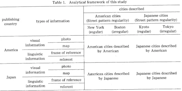
Table 1. Analytical framework of this study
tourist guides. After considering these differ ences, Suzuki claimed that there was a strong tendency for Japanese guidebooks to depend more on pictorial or visual devices for the pur pose of spatial information transmission, while
American guides were more likely to rely on linguistic expressions. He inquired whether these disparities reflect the differences in ad dress systems between countries.
Suzuki intended to demonstrate cultural di versity in the transmission of spatial informa tion from a cross-cultural viewpoint, by use of tourist guidebooks as a media in daily use.
However he gave an account of the diversity only for visual information. In other words, he did not study the other type of information vehicles-language. An additional problem lies in the limited number of guidebooks sampled, only four for each city. This is too small to generalize the result of the analysis.
As for the second problem, the research ex amples focusing on linguistic navigational ex pression with geographic perspective are not sufficient, and there is little information about how people actually use such an expression in a large-scale environment. Therefore, it is ever fruitful to analyze the linguistic information in guidebooks, because they encompass not only visual information but also linguistic informa tion.
The present study will further examine
Suzuki's investigation by analyzing both visual and linguistic information in the guides The number of guidebooks expanded into six for each city, and the spatial description contained there is analyzed. As for the map expression as visual information, a statistical test is done, using Analysis of Variance (ANOVA). Next, spatial description by the language used in the guides is analyzed both quantitatively and qualitatively for each city. This study aims to clarify how characteristics of geographic envi ronment and address systems influence human spatial description through depictions in infor mation vehicles.
The Framework of the Research and Method
Framework of this study
Tourist guidebooks are one of the most widely used media for traveling anywhere out side our familiar place, and contain multiple representational styles such as maps, photo pic tures and verbal descriptions; moreover, any one can purchase and carry them casually. Fur thermore, they are not biased for a specific audi ence, but are intended for general readers.
Therefore, the guidebook can be thought to reflect the general figure of the spatial descrip tion of the readers to a considerable extent.
As mentioned in the previous section on eco logical aspects of spatial description, socio cultural, environmental, and individual factors in the observed differences should be distin guished. Therefore, the difference in address systems between the countries were selected as a measure of a socio-cultural one; Japan has a typical example of address systems based on blocks, and America has a typical street-based address system. As shown in Table 1, I selected cities, which had regularity of street patterns varied in pairs for each country, because previ ous research has shown the effects of regularity on spatial cognition (Brown and Broadway
1981).
Kyoto and Tokyo were selected as the target cities in Japan. Kyoto is a city whose street pattern is highly regular, designed at a time in history when urban planning was based on an cient Chinese urban form. Tokyo is a city whose street pattern is less regular because the city is located on undulating plains and the urban ambit has spread gradually (Jinnai 1985).
As for the target cities in America, New York City and Boston were selected. The street pat tern in New York City (more precisely, Manhat tan Island) is designed in a highly regular form.
In contrast, since the central area of Boston has spread gradually during reclamation of the wa terfront, its street pattern is less regular. Then, six publishers were selected using the criterion that each should publish the guidebooks for these cities in the same series.3
Analysis of visual information
Visual information in this study includes spa tial descriptions other than linguistic informa tion, which is divided broadly into the maps and the photographs. For the maps, coloration, types of legends, map grids, site arrangement, and use frequency were set up as measures. For the photographs, frequency in use was assessed.
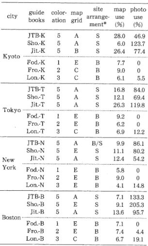
"Coloration" indicates the level of abundanc e of color given to the map. It can be divided approximately into three types as full-color, two-color and monochrome printings (not counting the ground-color "white"). Because a guidebook may use together among those, two more categories should be added giving five categories in total. Consequently, I employed
the scoring method of 1 for monochrome, 3 for two-color printing, 5 for full-color printing, and two intermediate expressions among those were scored as 2 and 4.
"Legend" means the number of
signs in an explanatory note for the maps of a guide. But , because American guides may add explanatory notes in every map, in this case, the largest one in a guide was counted.
"Map grid" means the device to
make an ob ject-site search easier, by marking two axes on the four corners of a map. Also, to add the number for each site indicating the page includ ing corresponding map is the other device of
"grid ." Thus, guides which included both de vices for all maps were scored as A, guides which adopted one of the two methods were scored as C, and guides with no coordinates on maps were scored as E. Again, guides with intermediate expressions were scored as B or D.
When each site was enumerated in its con text, "site arrangement" displays what the order was based on and how it was being done . Guides adopting the editorial line that all sites are ordered on the basis of their spatial proxim ity and are enumerated were classified into
"spatial
." Guides employing the editorial line that arranges the sites in context on the basis of their category of business were named "busi ness.,,
"Maps use" indicates the r
ate of map use per tourist guide, which was calculated by division of pages carrying maps by the total pages . As for photographs, "photos used" were counted up. Incidentally, photographs of cuisine , inte rior, or facial expression should not be catego rized as spatial description for navigation , so all those photographs were excluded.
Analysis of linguistic expression
Linguistic description of space in large-scale environment employs a variety of spatial ex pressions. To deal with them quantitatively, we must classify the elements contained in the linguistic expression. Past studies have used a variety of classification schemes for analyzing linguistic expression, and a clear standard for classification for directional terms has not yet been established. But there is some common ground among such studies.
6 SUZUKI K.
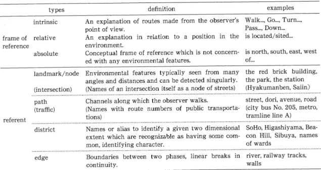
Table 2. Typology of the elements in spatial description by language
First I will consider classification based on the referential system and referent. Vanetti and Allen (1988) divided the sentence of the spatial directional terms into (1) environmental features and (2) spatial relational constructs.
The former indicates referents like landmarks or choice points, and the latter is indicative of spatial relational terms like direction and dis tance. Such a method of classification was also used by Allen (2000), although with modifica tions.
Second, many of the previous studies in tended to classify sentences based on verb func tions. Allen (2000) classified verbs into verbs of movement and state-of-being verbs. Similar classifications were devised by Taylor and Tversky (1996), who classified verbs into static
verbs used for route description, and active verbs used for survey description. Taylor and Tversky further sorted the terms into three categories of intrinsic, relative and eclectic ex pressions on the basis of the agent's observing point. In the previous studies, to classify the directional terms, at least the distinction be tween frame of reference and referent (for frame of reference, distinction of verbs which correspond to actor's view point), is necessary.
Consequently, the current study reflects past classification schemata in these two points
(Table 2).
According to Levinson (1996), frame of refer ence in linguistic description can be grouped into three categories: intrinsic, relative and ab solute. This corresponds to Hart's (1981) classi fication of frames of reference: egocentric, fixed and abstract. This study adopts the Levinson's categories.
Because previous studies of linguistic direc tion-giving were mainly interested in the lan guage structure of the sentence, the taxonomy of referent has not yet been established. But since Lynch's (1960) investigation, cognitive mapping research has addressed the question of what referent can be used as a cue. Also, some studies have reported that the way of using referents changed in connection with the char
acteristics of physical environments or with subjects' familiarity with the environment (Ap pleyard 1970; Pocock 1976; Evans et al. 1981).
In this study, referents of environmental fea tures were classified into six types (landmark/
node, intersection, path, traffic, district and edge) and then compiled.
The "landmark/node" referent operates as a cue to find a way to the destination, which is probably the same one as Lynch's (1960). How ever, during preliminary analysis I observed another usage, in which the destination itself
serves as a landmark. For example, in the case that a site is located in a distinctive building, the building takes on the function of landmark although a guidebook user can enter it. Also, when a guidebook user refers to a station as a cue and passes through it, the station takes on a hybrid function. In this study, therefore, both landmark and node were counted as in the same category.
The subcategory "intersection" referent ap peared predominantly in Japanese cities where most intersections are given their own names.
Hence, there are many cases where an intersec tion name is written in the guidebook using the icon of the signal in Japanese maps. When a guidebook described only "the intersection of street A and avenue B," it was considered to be describing two roads, rather than a specific in tersection name. As with landmark/node, the term "node" as used by Lynch (1960) does not include all words in this definition, although the intersection name functions as a kind of node.
"District" as
used in this study corresponds closely to Lynch's definition, indicating a given area name which is recognizable as having some common, identifying character. In Amer ica, place names such as "Villages," "SoHo," and
"Midtown" for are
as of New York City, and
"Beacon Hill" or "B
ack Bay" for areas of Boston correspond to this category. In Japan, this cate gory includes places such as "Shibuya" and
"Asakusa" in Tok
yo, and "Lion" or "Arashi yama" in Kyoto.
The "edge" referent almost always refers to a railroad or river. These can be distinguished in their function of blocking a path.
"Traffic" gives the d
escription of a way by providing the lines of public transportation. In a functional sense, this type can be included in the "path" category.
Using the categorization framework indi cated above, for example, the sentence "my house is next to your house" can be fractionated into one relative frame of reference ("is next to") and two referents ("my house" and "your house"). All 8,698 sites, except those sites that appeared in the form of box columns, all the tourist guidebooks selected for this study were quantitatively fractionated into reference frames and referents, and then counted.
Table 3. Results of the analysis of visual infor mation in guidebooks
* Types of arrangement display as follows:
S: ordered on the basis of their spatial proximity . B: ordered on the basis of their category of business.
Comparison between Two Countries, Four Cities
Analysis of visual information
Result of the analysis of the visual informa tion is shown in Table 3. Let us examine the maps first. All maps in the selected Japanese tourist guides were printed in full color without exception. On the contrary, in the American guidebooks, the variation of coloration was much larger than in Japanese guidebooks, and the regularity was not apparent.
Thus, the preciseness of the map expression is examined thereby. The Japanese maps 255
8 SUZUKI K.
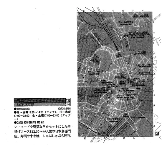
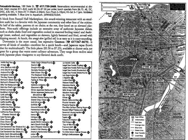
Figure la. A typical Japanese layout of spatial description in the guidebooks (the case of 'Tatsukichi,'
Boston).
Source: JTB 2001, p. 135. original size 18.1•~11.5cm.
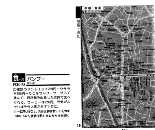
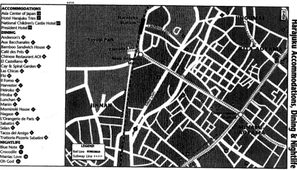
tended to show the environmental features in accurate outlines and were distinguished by colors in accordance with feature category (Fig ures 1 a and 2a). On the other hand, American guides drew most environmental features in geometric format with numbers (Figures 1b and 2b). Thus users cannot identify a certain site without referring to the listing, which is printed separately and sites are sometimes ar ranged in alphabetical order (see the site list ings of Figures 1b and 2b). In other words, Japanese maps were found to be more pictorial (MacEachren 1995) than maps of American tourist guides, which call on more advanced skill for acquiring information.
Incidentally, maps in tourist guides have the role of providing the positional information for each site introduced in the body text. There fore, maps should be closely associated with the body text to efficiently convey the spatial infor
mation. This point is illustrated by "map grid"
in Table 3. Even here, we can confirm Japanese guides contrived a way to tie a map to the text.
Next let us examine the frequency in use of maps and photographs (Table 3). The use fre quency in the Japanese guides exceeded that in the American guides by as much as 4.5 times.
This was especially true for the use frequencies of the Japanese guides for the Japanese cities.
However, the use frequencies for Tokyo and Kyoto did not differ significantly. Accordingly, we can conclude that the map use rate of Japa nese guides increased when they describe the more familiar (domestic) environment. There fore we conclude that Japanese tourist guides are much more likely to depend on visual infor mation as a primary medium for spatial de scription compared with American tourist guides. Results of two-way factorial analysis of-variance on the coloration, use frequencies of
Figure l b. A typical American layout of spatial description in the guidebooks with site list (the case of ' Tatsukichi,' Boston).
Source: Frommer's 2000, p. 103. original size 18.0•~11 .5cm.
maps and photos all revealed a significant effect of publishing country (Table 4).
Analysis of linguistic information
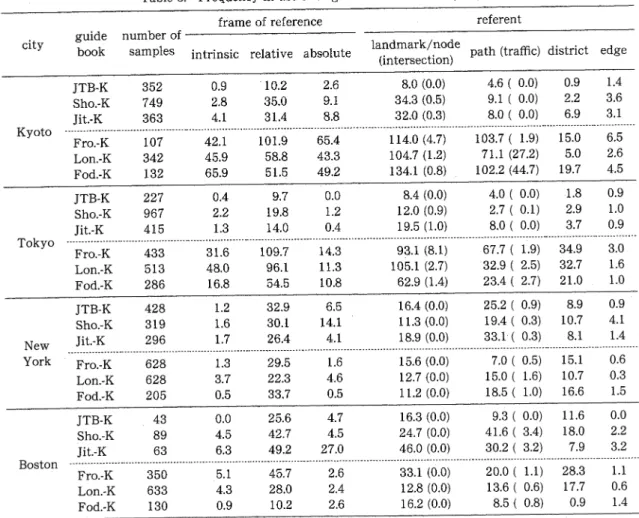
The results of linguistic analysis are indi cated in Table 5. The numbers in appearance of each reference frames and referents were di vided by the number of samples. At the outset of the analysis, results of reference frame were analyzed. As shown in Table 5, the reliance on linguistic information of spatial information transmission increased when the guides de scribed cities abroad compared with domestic ones.
In contrast, Japanese guides described their domestic cities with a higher frequency of map use than when they described foreign cities. It implies that increased reliance on linguistic in formation in unfamiliar environments is uni versal across countries. Thus in relatively un
familiar environments, linguistic information may be described in more detail to compensate for insufficient information provided by other spatial information vehicles.
To examine the relative effect of two factors (viz., publishing country and cities) on the us age of three types of reference frames, two-way ANOVA was carried out. Results of the analy sis are reported in Table 6. Although for the relative frame of reference, the null hypothesis was rejected at p<.01 level indicating that pub lishing country produces a significant effect, for the other reference frames, both factors pro duce significant effects for. Also, a significant interaction between publishing country and cit ies was observed at p<.01 level in all reference frames.
I here intend to examine in more detail the ANOVA results referring to Table 5. Regard less of the reference frame types, the increase in 257
10 SUZUKI K.
Figure 2a. A typical Japanese layout of spatial description in the guidebooks (the case of 'Bamboo,'
Tokyo).
Source: JTB 2000, p. 134. original size 16.0•~10.5cm.
use frequencies for Japanese cities tended to be higher than those for the American cities. Also, the disparity between Japanese and American tourist guides in use frequency values was
greater when they described Japanese cities. In contrast, the difference almost vanished when American cities were described. Such differ ences were comparatively apparent in case of intrinsic frame of reference, as compared to relative and absolute frame of reference. In particular for the description of American cit ies, some of use frequency highness ranks were found to be reversed.
The results for each city will be investigated.
As for Tokyo, American guides primarily used a relative frame of reference. Their use frequen cies ranged from a high value of 109.7 for Frommer's to a low of 54.5 for Lonely Planet.
Use of an intrinsic reference frame was 31.6 for Frommer's and 16.8 for Lonely Planet. How ever, the use frequency values for a relative frame of reference were lower for Kyoto than
for Tokyo. In contrast, the values of intrinsic and absolute frames of reference for Kyoto gen erally exceed those for Tokyo.
In the meantime, the use frequency values of absolute frame of reference in Japanese guides have the same tendency in that those for Kyoto are higher than Tokyo. Consequently, at least we can conclude that absolute reference frames tend to be used more in relation to characteris tics of the physical environment (viz., regular ity of street pattern) than to social or cultural factors.
However, for the relative frame of reference, the use frequency values for Tokyo tended to fall short of the values for Kyoto. The use frequencies of relative frame of reference in Japanese guides were slightly higher for Boston than for New York.
Tokyo has comparatively irregular street patterns, and they make the city difficult to navigate through linguistic information alone.
Therefore, it would appear that it is more reli
Figure 2b. A typical American layout of spatial description in the guidebooks (the case of 'Bamboo ,' T
okyo).
Source: Frommer's 1998, p . 131. original size 18.0•~10.2cm.
able and efficient for Japanese guidebooks to depend on visual information. On the other hand, the American cities have different ad dress systems, which certainly makes the iconic cues in visual information unfamiliar for Japa nese and more difficult to describe than for domestic cities. Then we can consider that Japanese tourist guides have to supplement maps with linguistic information, as the Ameri can tourist guides do for describing Tokyo.
American tourist guides depend much more on linguistic information in describing foreign cities than do Japanese guides. In the Japanese guides, the highest use frequency of relative reference frame was for Boston (values of 25.6 , 42.7, 49.2 respectively), which was about twice as high as that for Tokyo (9.7, 19.8, 14.0). In contrast, in the American guides the use fre quency for Tokyo (109.7, 96.1, 54.5) was three
or four times as high as that for New York (29 .5, 22.3, 33.7 respectively), and the values for Bos ton were almost identical to New York's . It is concluded that the American tourist guides generally rely more on linguistic information than do the Japanese ones, and this is especially true when unfamiliar environments are de scribed.
The findings stated above confirm that the relative reference frame is the most basic and frequently used one for orienting oneself in a large-scale environment. The other reference frames are subsidiary and flexibly employed with reference to the place characteristics .
As stated above, even though they are all categorized as linguistic information, some lin guistic usages tend to be tied to the environ mental characteristics strongly, and others not . Frames of reference are not necessarily tied to 259
12 SUZUKI K.
environmental features or cues. On the con trary, referents by themselves are able to de scribe the features or cues. Therefore, it is conceivable that referents reflect the socio-
Table 4. ANOVA: Visual information variable
n.s: not significant at 0.05 level
df: degree of freedom; F: F value; p: significance level
Table 5. Frequency in use of linguistic information by types
Note: The use frequencies represent the percentages in use of each guidebook, which were calculated by times in use of each frame of reference and referent divided by the numbers of samples of each guidebook. Because one site may
contain the sentences consisting of more than one frame of reference and referent, the percentages may be more than one hundred percent.
Table 6. ANNA: Types of reference system
n.s: not significant at 0.05 level
dl: degree of freedom; F: F value; p: significance level
Table 7. ANOVA: Types of referent
n.s: not significant at 0.05 level
df: degree of freedom; F: F value; p: significance level
cultural contexts or environmental characteris tics more directly than reference frames.
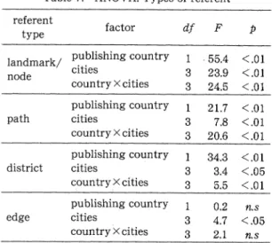
Two-way factorial analysis of variance was applied with respect to the variables of publish ing country and cities for referent types (Table 7). Effects of interaction were found in all types of referents except for "edge." Moreover, the results for referents disclosed a main effect of the cities factor for all referent types, whereas the result for reference frame revealed the uni lateral main effects of publishing country.
In case of the Japanese guidebooks, the use frequency of "landmark/node" for Kyoto ex ceeded that for New York, then the explanation that the high value is related to the difference between the cities of Japan and America does not work. Instead, the use frequency for New York was the second lowest following that for Tokyo. Therefore, the explanation that the street patterns affect the use frequency also does not work. Consequently, as for Japanese guidebooks, the usage of "landmark/node" indi cates a marked tendency to be determined arbi trarily. The use frequency for the referent term
"path" was highest for Boston followed by New York, then Kyoto, and finally Tokyo, and the same trend was found for the "district" referent.
Then, use frequencies of American guide books will be considered. For all of the refer ents except "district," the use frequencies were highest for Kyoto followed by Tokyo, then Bos
ton, and finally New York.
For "path," the streets in American cities hav ing their own names is supposed to be the rea son that the use frequency rate of American guides contend with the rate of Japanese guides. And yet the results clearly indicate higher rates for Japanese guides compared with American guides.
A different result was found for "district,"
with the rank order progressing from the high est: Tokyo, Boston New York to Kyoto. It is conceivable that this order is dependant on the street pattern complexity. Specifically, Tokyo has irregular street patterns and an unfamiliar environment for most readers. As with the
"traffic" referent
, "district" was most frequently used in Japanese guides describing Boston and American guides describing Kyoto. The result can be due to the modes of transportation in both cities, in that people in Boston have to rely on metro for transition just as the people in Kyoto depend heavily on city bus.
Consequently, we can conclude that the us age of referents varies with their types. Some referents are affected by socio-cultural factors , but others are affected by environmental char acteristics.
Yntra-urban Variations of Spatial Descriptions
In the last section I established that the us ages of given types of linguistic information were considerably influenced by differences in environmental characteristics of the city. This implies that the spatial description varies also with local conditions of the environment within the city, Hence, I will make a further examina tion of this matter comparing intra-urban dis tricts in a given city, focusing on their environ mental characteristics.
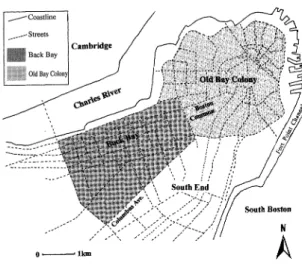
The case of Boston
The central area of Boston is located on a peninsula which extends between the Charles River and Fort Point Channel. Excluding the surrounding areas of Cambridge, Charlestown, and South Boston districts, the central area can be divided into two zones (Figure 3). One is the precinct comprising the North End, Beacon Hill,
261
14 SUZUKI K.
Figure 3. Map of central Boston with the seg mented areas.
or Downtown districts. This precinct, formerly called Bay Colony, was colonized by England circa 1630 A.D. Most of the early historical buildings are clustered here, and the street pat
terns are irregular. I labeled this region "Old Bay Colony."
The other precinct, called "Back Bay," faces the old bay colony from the west side. The Boston Common is sandwiched in between these two precincts. Back Bay was formed by the reclamation of waterfront since 1857. The street patterns are regular because of the recla mation and community planning (Whitehall
1959). Most of the retail shops and stores are clustered here.
The "Financial District," "North End," "Down town" and other zones within Old Bay Colony are commonly known names, and they are sometimes coupled to each other and used in accordance with the given intentions of the tourist guides. Also, the Back Bay is sometimes coupled to the South End in some of the tourist guides. However, there was no categorization which coupled Old Bay Colony districts to Back Bay. Therefore I divided central Boston into three segments: Old Bay Colony, Back Bay, and other areas (Figure 3).
The results indicated the predominance of the Old Bay Colony in use frequency rates for both reference frames and referents (Figures 7 (a), 7(b)). As for the proportion of each reference frame in use frequencies, Figure 7(a) indicates a
significant dependency on relative frame of ref erence in Back Bay, regardless of the publishing countries. The component ratio of the use fre quency is changed considerably in the Old Bay Colony. The greater amount of linguistic infor
mation by mixed expression using plural frames of reference was applied for describing the sites in Old Bay Colony. The same tendency was found for referents (Figure 7(b)). Conse quently, we can hypothesize that the character istics of Old Bay Colony increased the necessity of depending on linguistic information. Also, it can be deduced that as the linguistic descrip tion used more detail to describe an intricate environment, other frames of reference and ref erents were added to the relative reference frame and landmarks.
The case of New York City
The most urbanized area of New York City is located on Manhattan Island and can be divided
into two districts. One comprises the southern part of Manhattan that was originally named
"New Amsterdam" and inhabited since around 1625. The other comprises the central and northern part of Manhattan. That area has developed by a town demarcation project called
"The . Commissioners' plan of New York City"
(Koolhaas 1978).
Because the southern part of Manhattan opens onto estuaries, the landform is tapered, and the street pattern is irregular because it had developed before the city planning. In contrast, the street pattern in central and north ern part of Manhattan is regular as a result of city planning (Figure 4). Historical and urban morphological variance is also reflected by the system of addresses in both districts.
In the central and northern part of Manhat tan, street numbers extend from south to north, and avenues extend from east to west. In con trast, the address for southern Manhattan is less systematic. Some order can be seen, in that the alphabetical numbering system is applied on the avenues around East Village, but street names are randomly assigned to quasi-regular roads, which stem from the irregularly shaped landform. Therefore, the northern part (Chel sea, Gramercy, Midtown, etc.) can be divided from the southern part (Villages, SoHo, Little
Figure 4. Map of New York City with the seg mented areas.
Italy, Lower Manhattan, etc.) at 14th Street.
Figures 7(c) and 7(d) show the results for analy sis of use frequency rates for both frames of reference and referents.
First, let us consider the result for frames of reference. As noted, the two parts of Manhat tan can be distinguished by the street pattern regularities. If frames of reference are chosen relevant to the environmental characteristics, the use frequency of absolute frames of refer ence should be different between the two zones of Manhattan. Figure 7(c) demonstrates that this hypothesis holds true for Japanese tourist guides. However, the result for American guidebooks defies the prediction.
The most striking difference among referents can be seen for the "district." In all tourist guides, the frequency rates for the southern part exceeded those for the central part. It can be due to the difference in street pattern com plexity. Consequently, as in the case of Boston, we can conclude that environmental character istics influence the usage of linguistic informa tion.
Figure 5. Map of central Kyoto with the seg mented areas.
The case of Kyoto
Japanese and American tourist guides dif fered in the way they divide Kyoto into sec tions. Japanese guides divided up the city in detail using common names (Nishijin, Kita yama, Higashiyama), and then described each site within the area. However, American guides tended to use absolute directional categoriza tion on the basis of four cardinal points from central Kyoto (eight cardinal points or common names were used accessorily). In other words, the American guides used an arbitrary categori zation and did not employ Japanese place names. Since there were no clear borders among them, there is no way but to comply with their categorization.
Historically and morphologically, the street pattern of Kyoto is based on the urban planning of ancient Kyoto (Heian-kyo), which used a grid pattern. However, the address system is com plicated because of the mixed existence of his torically established block zoning and the more modern postal address system, which was con stituted in Meiji-era (Hiraoka 1978). On account
263
6 SUZUKI K.
Figure 6. Map of central Tokyo with the seg mented areas.
of this, it seemed not worth to make the detailed categorization in reference to Japanese guides.
Therefore, a dichotomous sorting was em ployed for Kyoto. As indicated in Figure 5, one region is "central" (Raku-chu area) and the other is the "perimeter." Figures 7(e) and 7(f) indicate the predominance in use frequency rates of "perimeter" compared with those of
"central
," without reference to the publishing countries. As for use frequency rates of each frame of reference, Figure 7(e) clearly demon strates the higher use frequency rate of intrin sic reference frame in the "perimeter" area. As with the case of Boston and New York city, this trend can be due to street pattern complexity.
As for the rates of referents, the rate of
"traffic" was higher for Kyoto than for the other cities, and the rate was higher in the "perime ter" area than in the "central" area. This was a distinctive trend for Kyoto. Therefore, I inves tigated in more detail the sites which used the referents in their linguistic information and found that almost of all the sentences consisted of the route numbers of public transportation
systems or of route-based directional expres sions. For example, "take bus No. 205 or Toku
17 from Kyoto station (bus terminal) to the Kawaramachi-marutamachi-mae stop" (Lon.-K, p. 155). Kyoto depends heavily on the city bus as the primary means of transportation. There fore it can be concluded that it is more effective to indicate the topological relationships of ori gins and destinations using bus stops and path ways than to describe their geographical rela tionships, and it forced a change in the way of describing relationships in the tourist guides.
The case of Tokyo
All tourist guides employed the historical names of given regions or station names for sectionalizing Tokyo, so this classification was adopted in the present study. However, espe cially in Japanese guides, the classifications were too finicky and made the numbers of sites for each group too small to be analyzed in a
quantitative way. Also, some guides grouped together more than one region (e.g., Roppongi and Azabu). Therefore, taking care that the grouped regions were kept together, I divided the regions in two categories on the basis of street-pattern regularities. One is the Yama note upland area, characterized by relatively non-regular streets because of many hills, and the other is the Shitamachi lowland area, con sisting of old downtown Tokyo with relatively regular street patterns (Figure 6).
Figures 7(g) and 7(h) demonstrate that use frequency rates were correlated with the degree of street pattern complexity. However, this result contradicted the ones for other cities, asserting that street pattern complexity does not always explain the degree in dependency of linguistic information. This tendency was seen without regard to publishing country. There fore, it does not stem from socio-cultural dif ferences in the way of expression, but from the environmental characteristics in Tokyo. We can not easily find the reason of this inconsis tency. Perhaps, the spatial scale of Tokyo (which is much larger than the others) affected this result (see Figure 7). Each region in Tokyo bears comparison with the whole central areas of the others in square measure, which may make it difficult for the two areas to be com
Figure 7. Use frequencies of frames of reference and referents for each city , (America: American guidebooks Japan: Japanese guidebooks)
pared simply by street pattern.
Consequently, we can summarize the results in this chapter as follows. First, the results obtained from the cities except Tokyo gener ally indicated that there is an inverse relation ship between the degree of regularity of street pattern and the quantity of spatial description by language demonstrating the street pattern complexity.
Second, the way of employing reference frames also varies in relation to street pattern
complexity. The more complicated expres sions, with mixed use of frames of reference in addition to relative reference frames, tended to be employed in urban regions with relatively lower street pattern complexity. We can con clude the same for the usage of referents . In general, landmarks were the most fundamen tally used referent type as asserted by Tversky and Taylor (1996). In addition, it became clear that the other referents were likely to be addi tionally employed in places with relatively
265