九州大学学術情報リポジトリ
Kyushu University Institutional Repository
チナンパ世界遺産登録地における重要景観要素とし てのアウエホテの保全計画に関する研究 : メキシコ 市南部のミルパ・アルタ、トラウアック、ソチミル コに位置する農村地域を対象として
レイエス, プラタ, ハイロ, アグスティン
https://doi.org/10.15017/1441247
出版情報:Kyushu University, 2013, 博士(芸術工学), 課程博士 バージョン:
権利関係:Fulltext available.
チナンパ世界遺産登録地における重要景観要素としてのアウエホテの保全計画に関する研究
―メキシコ市南部のミルパ・アルタ、トラウアック、ソチミルコに位置する農村地域を対象として―
Planning Requirements for the Conservation of Ahuejote Tree as a Key Landscape Element in the Chinampa World Heritage Site of Milpa Alta, Tlahuac and Xochimilco, south
Mexico City
レイエス プラタ ハイロ アグスティン Jairo Agustin Reyes Plata
2014年2月
Table of Contents
page CHAPTER ONE
BACKGROUND AND LITERATURE REVIEW 1
1.1 The ancient use of ahuejote in chinampas 4
1.2 The variety of perspectives on chinampas: the habitat of ahuejote 7 1.3 The outstanding value of chinampas in the context of cultural landscapes
11
1.4 The characteristic features and importance of ahuejote in the landscape character of chinampas
14
(1) The features and current importance of ahuejote in chinampas 14 (2) Some factors relating to the loss of ahuejote in chinampas 17
1.5 The need of this study 19
CHAPTER TWO
THE METHODOLOGY OF THIS STUDY 20
2.1 Objective of this study 20
2.2 The study site 21
2.3 The characteristics of sources of information 25
2.4 The study units 28
2.5 The organization of this thesis 33
CHAPTER THREE
CITY PLANNIG FRAMEWORK FOR CHINAMPAS 36
3.1 Features of City Land Use and Rural Planning in the regulation of chinampa
36
(1) Land use policy at a large scale 36
(2) Land Use Policy at a Local Scale 41
CHAPTER FOUR
CHARACTERIZATION OF THE EXISTING CONDITIONS FOR AHUEJOTES IN CHINAMPAS
44
4.1 Assessment of the key landscape elements in chinampas 44 (1) The density of ahuejote planting in chinampas 44 (2) Water resources and water units in chinampas 46
4.2 Assessment of existing conditions for ahuejote in the rural area in chinampas
52
(1) The characteristics of land use types in the rural area in chinampas 52 (2) The characteristics of chinampero density 54 (3) The characteristics of crop diversity types 56 (4) The characteristics of open field agriculture types 59 (5) The characteristics of agricultural types 61 4.3 Assessment of existing conditions for ahuejote in the urban area in chinampas
63
(1) The characteristics of urban density 63
(2) The characteristics of drain cover 66
4.4 Landscape characterization relating to existing conditions of ahuejote in chinampas
68
(1) The landscape character types relating to existing conditions of ahuejote in the rural area in chinampas
68
(2) The landscape character types relating to existing conditions of ahuejote in the urban area in chinampas
75
CHAPTER FIVE
THE MANAGEMENT CATEGORIES FOR THE CONSERVATION OF AHUEJOTE 78 5.1 The legibility of chinampa structure from the distribution of ahuejote 78 5.2 The significance of ahuejote from the landscape character types 80 5.3 The management categories for the conservation of ahuejote 83
5.4 Discussion and conclusions 91
List of tables List of figures
Notes and references Annex
1 CHAPTER ONE
BACKGROUND AND LITERATURE REVIEW
The review of previous studies on chinampas provides the point of reference in discussing the importance of ahuejote in Mexico City’s landscape. Ahuejote is a tree that has been utilized in chinampas since pre-Columbian times; therefore, the chapter starts with a sketch of the historical background of chinampas. This is followed by an exploration of the studies that today integrate the different visions on chinampas. A key message here is that the preservation of ahuejote relies on the management of chinampas as a site of multiple values and complexities.
Afterwards, the chapter centers on describing the features of ahuejote, its contributions to chinampas, and the problems that it faces. The chapter ends with the argument of the need of this study for the preservation of ahuejote.
Literature review included references about chinampas in articles, thesis, technical reports, and journals online from Mexican and international databases, such as Sciencedirect.com and the network of Scientific Journal for Latin America and the Caribbean, Spain and Portugal (Redalyc.org). The search also included the online collections of libraries from the National University of Mexico (Spanish: Universidad Nacional Autonoma de Mexico), the National Institute on Agricultural, Forestry and Livestock (Spanish: Instituto Nacional de Investigaciones Forestales, Agricolas y Pecuarias), the National Institute of Ecology (Spanish: Insituto Nacional de Ecologia) and the Universite Paris IV-Sorbonne (France).
Literature in Spanish, English and French languages was gathered, selected and organized into five thematic groups as shown in table 1-1: Agriculture, History, archeology and heritage, Land use, urbanization and planning, Ecology, and Water. Table 1 contains an overview of articles on each thematic group. Additionally, keywords relating to each thematic group were identified.
2 Table1-1 Selected literature relating to chinampa
Author Language Literature
sort Content summary
1) Agriculture
Keywords: agro-ecosystem, agricultural diversity, human management, greenhouse, chinampero
Losada et al. ,(2011) English Article Characterization of agricultural systems in the suburban and peri urban areas of the south of Mexico City.
Soriano-Robles et al.,
(2010) English Article Evaluation of energy flows and efficiency of the chinampa system.
Soriano et al., ( 2002) English Article Assessment of the economic performance of chinampa regarding its agricultural diversity.
Losada et al., (1998) English Article Changes of urban agriculture over time in the south of Mexico City.
Gonzalez –Jacome, A.,
(1993) English Article Characteristics of traditional agro-ecosystems in the central Mexican high lands.
Jimenez-Osorio J.J. and Gonzalez-Pompa, A., (1991)
English Article Human management of crops and its impact on the conservation of agricultural diversity.
2) History, archeology and heritage
Keywords: land reclamation, chinampa, monument, culture, heritage Gonzalez, A. at al.,
(2010) Spanish Book Catalogue of chinampas in San Gregorio Atlapulco.
Sanchez, A., (2008) Spanish Book Recompilation of historical essays on chinampa Terrones, E. et al.,
( 2004) Spanish Book Historical recompilation of politic, urban and environment aspects in Xochimilco. Period 1929-2004 years.
Peralta, A. at al. ,(1992) Spanish Book Catalogue of architectural and urban monuments in Xochimilco.
Armillas, P., (1971) English Article
Archeological research to verify the historical data on the development of Aztec Land Reclamation in the Valley of Mexico.
3) Land use, urbanization and planning
Keywords: wetland, urbanization, informal settlements, land use change, land use policy Aguilar, A. et al.,
(2013) English Article Estimation of ecosystem services from suburban wetland (chinampa) in Mexico City.
( to be continued in next page)
3 Table 1-1 Relevant bibliography relating to chinampa(comes from previous page)
Author Language Literature
type Contents
3) Land use, urbanization and planning
Wigle, J., (2010). English Article
Policy on the management of irregular settlements in the conservation land on Mexico City based on the study of the Program of Urban Development in Xochimilco (Xochimilco borough).
Wigle, J., (2009). English Article
Study on the social dynamics of informal human settlements based on the case study of Ampliación San Marcos (Xochimilco borough).
Clauzel, S., (2008). French Doctorate Thesis
Comparative study on the dynamics of land occupation and land use changes in the urban wetlands of chinampa (Mexico) and hortilonnages d’Amiens (France).
UNESCO,( 2006) Spanish Book Memory of the Master Plan for the World Heritage Site Milpa Alta, Tlahuac y Xochimilco.
Ezcurra, E.,(2010) Spanish Book Memory on the urbanization of the Basin of Mexico 4) Ecology
Keywords: ahuejote, malacosoma, muerdago, pollution, chinampas Anda, R., &Villa, A.
(1991)
Spanish
Article Dasometric, phenological and sanitary study on ahuejote (Salix bonplandiana) in Xochimilco
Stepahn Otto, E., (1993) Spanish
Book Varying aspects of ahuejote in the chinampa.
Outerbridge, T., (1987) English Article Historical outline of chinampa and its decline over time 5) Water
Keywords: aquifer, overexploitation, land subsidence, wetland, lake, environmental decline
Oswald, U., (2011) English Article Environmental and administration issues on water security in the Metropolitan Valley of Mexico City.
Ortiz, D. del C. and
Ortega, M.A., (2007) English Article Origin and evolution of a new lake in Tlahuac and its implications for land subsidence and flooding hazards.
Excurra, E. and Mazari-Hiriart, M., (1996)
English Article Population growth and environmental decline in the basin of Mexico
Gonzalez-Moran, T.
Rodriguez, R. and Cortes S.A., (1999)
English Article Environmental issues related to water abstraction in the basin of Mexico.
Mazari, M. and Mackay,
D.M., (1993) English Article Potential for groundwater contamination in Mexico City.
Durazo, J. and
Farvolden, R.N.,(1989) English Article Evolution of groundwater regimens in the Valley of Mexico based on the review of historical evidence.
4 1.1 The ancient use of ahuejote in chinampas
Ahuejote is a tree that was utilized in the construction of chinampas. Chinampa is a method to reclaim land for agriculture purposes on swamps. Archeological studies indicate that chinampas were structured in the Basin of Mexico in pre-Columbian times 11).
In the 16th century, five shallow lakes, between 800 and 1000 km2, covered the Basin of Mexico. As illustrated in fig.1-1, the two lakes in the North were called Zumpango and Xaltocan, the two lakes in the South were known as Xochimilco and Tlahuac, and the lake in the Center was called Texcoco. The Basin of Mexico is an endorheic basin; therefore, the lakes used to join often as a single body of water during the rainy season of high water levels and tended to separate into individual bodies of water in the dry season. As can be seen in the scheme of lakes levels in the fig.1-1, Lake Texcoco was the lowest of all lakes, so water drained ultimately towards it.
Fig.1-1 Chinampas in the Basin of Mexico in the 16th Century (Map based on Armillas Gil, I. et al. (2010). p. 53) 12)
5 Lakes Xochimilco and Chalco formed part of a subbasin in the south of the Basin of Mexico.
The lakes covered 148 km2 of a shallow plain that were fed by freshwater and contained plenty of wildlife and lush aquatic vegetation.
To control the water levels in lakes, Aztecs conducted large efforts to construct various sorts of waterworks, such as waterways, dikes, aqueducts and chinampas. Tlatoani acolhua Nezahualcoyotl 67, an Aztec emperor, built a dike that divided Lake Texcoco in two districts, east and west. The west District, where the capital of Aztec Empire, Tenochtitlan, was located, was named Lake Mexico. With the new organization of lakes, Lake Mexico remained linked to the southern lakes Xochimilco and Chalco, from freshwater was found. The communication among those three lakes (Mexico, Xochimilco and Chalco) was supported by a series of canals and bodies of water that provided direct routes of transportation to Tenochtitlan.
In the 16th Century, the chinampa region covered approximately 120 km2 in Lakes Xochimilco and Tlahuac. Chinampa plots covered 9,000 ha. Canals and other bodies of water occupied the remaining surface 11). At the time of Spanish contact (1521), Tenochtitlan had 12 km2 in extension. Its population reached 150, 000 to 200,000, who annually demanded 30,000 to 40,000 MT (metric ton) of maize to cover nourishment needs 12). To supply the need of such size, chinampas were employed as part of a food production system that contributed to the agricultural self- sufficiency in the city region 35).
The horticulture system in chinampas annually produced 20,000 MT of maize to nourish some 100,000 people in Tenochtitlan 12). The high productivity of chinampa horticulture was because of the use of almacigo34), a seedbed that was utilized for germinating vegetable seeds.
Almacigo was an Aztec innovation that allowed intensive cycles of production all year. Some of the crops that were cultivated in chinampas included corn, tomatoes, chili, cabbage, bean and flowers 67).
Another factor that contributed to the productivity of chinampas was the chinampa itself.
Chinampas were designed to be narrow to capture moist permanently at root level. As can be seen in fig.-1-2, chinampas were surrounded by canals, which worked similar to an irrigation system. Studies 11), 12), 61) describe that the first step to make a chinampa was to locate a foundation or ‘cimiento’ near a lake edge with shallow depth, around 2.52 to 3.36 meters. A rectangle of about 6 to 9 meters was then marked to define the chinampa boundaries. The next step was to create a dense organic bed or ‘cesped’ by piling vegetation cut from the lake edges.
Mud from the lake bottom was piled on top of cesped to raise the chinampa to about 0.84 meters above water. The chinampa’s edges were reinforced by branches and ahuejotes, which are planted all around, 4 to 5 meters along the edges. Ahuejotes grew rapidly and fixed the chinampa to the bottom, preventing terrain from eroding. The chinampa was then ready for agriculture. .
6 Fig.1-2 Scheme of chinampas
Drawing by Cathya Guzmán Herrera
The construction of chinampas supposed the landscape transformation of lakes in the Basin of Mexico. An illustration by Miguel Covarrubias helps visualize the chinampas as seen in the basin of Mexico’s horizon in combination with lakes, mountains and other waterworks.
Chinampas formed a singular sort of land use that reflected a model of a city based on the comprehension of water conditions in the basin of Mexico City 23). For example, in Tenochtitlan, the chinampas were separate properties, which contained a house, a garden, and ahuejote trees that surrounded the chinampas. Ahuejotes became a characteristic element of chinampa land use and, as a consequence, a key element in the composition of chinampa landscape character.
Today, some 2,440 ha of chinampa remnants can be seen in the south of Mexico City. The ahuejote is still the tree of chinampas.
7 1.2 The variety of perspectives on chinampas: the habitat of ahuejote
The review of previous studies on chinampas prepares the terrain to approach to the complexity of ahuejote’s settings.
In the beginning of the 1970s, the investigations focused on documenting the archeological evidence of chinampas in the basin of Mexico. The studies conducted by Armillas (1971) 11) in the south of Mexico City, based on aerial photos and field work, noted that chinampas consisted of a land reclamation method, which was utilized by pre-Columbian civilizations, to expand farmland over the ancient swamps and lagoons in the Basin of Mexico. His work indicated that chinampas represented an exceptional example of native technology used in wetland conditions.
Armillas contributed to comprehend that chinampas had a strategic role in the florescent of Aztec civilization, and they were utilized in the reorganization of the landscape in the south of the basin of Mexico (See this chapter, section 1.1).
Armillas Gil et al. 12) cites that contemporary studies of Armillas, conducted by Calnek (1972), Coe (1974), Sanders at al. (1979) and Parsons et al (1982), were systematically adding new archaeological evidence that confirmed the presence of chinampas in many places across the basin of Mexico, but that the only chinampa remnants were localized in the south of Mexico City, particularly in Xochimilco.
In 1986, the Mexican authorities recognized the importance of preserving chinampas and pre-Columbian towns through the designation of the “Historical Monument Zone in Boroughs Xochimilco, Tlahuac and Milpa Alta” 30) (Spanish: Zona de Monumentos Historicos de las delegaciones Xochimilco, Tlahuac y Milpa Alta”). The zone covered an 86.63 km2 area, including chinampas and twelve towns from pre-Columbian origin.
Using the 1986 designation as basis, the Mexican authorities proposed Xochimilco to be included in the World Heritage List in 1986. UNESCO accepted the nomination and, as will be detailed in this chapter, section 3, Xochimilco and the Historical Center of Mexico City were designated as a World Heritage Site in 198785).
The designation of chinampas as a World Heritage Site in 1987 witnessed a growing interest in chinampas. The 1987 designation stated the vulnerability of chinampas to environmental decline and argued the need of protecting traditional chinampa agriculture. A report by Outerbrigde (1987) 61) noted, for instance, the disappearance of chinampas due to water pollution, the introduction of mechanized agriculture systems for cultivation, and urban expansion.
Studies conducted by Ezcurra (1990) 25), Mazari and Mackay (1993) 48), Ezcurra and Mazari-Hiriart (1996) 26), and Gonzalez-Moran et al. (1999) 38) often referred to water problems in Xochimilco as a consequence of unsuitable schemes of water management in the basin of Mexico. Their studies reveal that water management in the basin of Mexico is technically a
8 combination of overexploitation of the aquifer, low rate of groundwater recharges, high supply costs, inefficient reuse of water and a complex system of water distribution.
The management of water has affected agricultural activities in chinampas. A historical research conducted by Arechiga 10), for instances, noted that 1901 saw the beginning of the exploitation of the springs in Xochimilco and the construction of an aqueduct to supply water to the center of Mexico City. The water exploitation provoked the depletion of the springs. In 1957, the water table of canals had dropped and it caused navigation difficulties. In response, city authorities started with the supply of treatment water to the chinampas to recover the water table in canals in 1959. Treatment water contained high concentrations of organic matter, provoking the proliferation of exotic plants such as Ecchornia crasipes (Spanish common name: lirio acuatico) along canals. Since then, chinampas are supplied with water from treatment water plants.
In 1989, after the World Heritage Site designation, the Federal Government of Mexico launched the ‘Plan for Ecological Rescue of Xochimilco’ as part of an official initiative to create water reservoirs and recreation facilities on the north of Xochimilco to enhance water management. With this move began a period of plans marked by ecological approaches to the management of chinampas, at least in paper.
In 1992, as an effort to conserve chinampas in Xochimilco, the Mexican authorities signed a decree on the creation of the Natural Protected Area (or natural reserve) “Ejidos de Xochimilco and San Gregorio Altlapulco” 30) (Spanish: Area Natural Protegida sujeta a conservacion ecologica “Ejidos de Xochimilco y San Gregorio Atlapulco”). The decree provided the first planning framework of management of chinampas. Its ecological approach centered on protecting chinampas and wetlands as priority sites for the generation of environmental benefits, for instance, aquifer recharge and climate regulation 30). The decree demanded the promulgation on a site plan for the management of the natural reserve within a short period (3 years); however, the site plan was delayed until 2006, 14 years after the decree66).
A further parallel theme in the study of chinampas is the chinampa agriculture. The first studies on chinampa agriculture often denote the efficiency and self-sustaining qualities of traditional agriculture methods in chinampas.
Traditional chinampa agriculture is described as a polyculture system that wisely integrates the use of own natural elements, such as water, soil and plants, into the agriculture process 34), 37). Polyculture features a wide variety of crops under a scheme of rotation based on the use of the almacigo, which is a seedbed. As shown in fig.1-3, the formation of the almacigo (1) begins with digging a shallow trench on a chinampa plot. Next, (2) the chinampero takes out agua-lodo, which is mud rich in organic matter from the canal bottom, and it includes the waste of plants that grow in chinampas, like ahuejote. (3) The mud is cleaned of any garbage, plants or roots
9 and poured onto the trench until it is completely filled. (4) The mud is left for two to three days until it dries to the consistency of a gelatin. Then, (5) the mud is carefully marked into squares with a string and cut along the lines with a large knife to form cubes known as ‘chapin’. (6) A hole is poked in each ‘chapin’ and a seed is dropped into each hole. (7) A fine layer of manure is spread on the almacigo. When the seeds have germinated, (8) plants are taken from the almacigo and transplanted to the chinampa, where they will continue their growth. Thus the chinampero, the chinampa peasant, can begin working on the next crop while waiting for the harvest of the current one.
Fig.1-3. Use of almacigo in chinampas
(Photos 1,2 and 6 by David Jimenez from ‘La casa de la chinampa’, photos 3-5 and ( by the author)
Crops with different growth cycles can be sown on the same chinampa but harvested at different times. Crop rotation introduces biomass in soil, helping the maintenance of its fertility and, as a consequence, contributing to the success of chinampa agriculture 37), 46). Traditional chinampa agriculture also involves a high level of biodiversity because the management of many different domesticated and non-domesticated plants that grow in the plots or nearby canals 46).
10 With the decline of environmental conditions, recent studies focus on evaluating the efficiency of traditional agriculture in face of the introduction of new methods for cultivation in chinampas. For instance, a study conducted by Soriano-Robles et al. (2010) 81) noted that, in comparison with other agricultural methods to chinampas, such as greenhouse and dairy cattle units, traditional agriculture is shown to be more efficient. They evaluated the energy flows of each agricultural method and found that agricultural methods that recycled own wastes had better energy efficiency. In this line, Merlin-Uribe (2009)50) compared the economic profitability and ecological sustainability of traditional chinampa agriculture and greenhouses. He found that the benefits that chinamperos obtained from agriculture depended on the investment in agricultural inputs. Greenhouse agriculture required high levels of investment in agricultural supplies to start the productive cycle in comparison to traditional agriculture. The economic profit from greenhouses appeared to be higher than the chinampa’s. However, greenhouses highly depended on external inputs to generate such profit, whereas traditional agriculture utilized the materials that had in chinampas. Merlin-Uribe concluded finally that the traditional chinampa agriculture resulted to be more ecologically sustainable.
Latest studies on chinampas focus on the identification of land use changes and the local dynamics of land occupation. Studies on urbanization confirmed that city plans have been overwhelmed by the urban pressure on chinampas even if there were many designations and plans to protect chinampas. A study conducted by Clauzel (2009) 18) investigated the evolution of the chinampa land use types in the boroughs of Tlahuac and Xochimilco between 1974 and 2004. Her study, based on photo interpretation, showed that chinampas changed from 2,745 ha in 1974 to 1437 ha in 1994, and reduced to 1329 ha in 2006. On one hand, changes such as those indicated a 48.41% reduction of chinampa area. On the other hand, it showed the diversification of chinampa land use during the last decades. Her results showed that chinampas changed from a land that was essentially dedicated to agriculture in 1974 into multiple land uses in 2004. Changes implied that agriculture modes were diversified, abandoned land was extended and urbanization was increased.
In 2012, Merlin-Uribe et al. 51) quantified the changes of land uses and land cover through a satellite image analysis on chinampas and wetlands in Xochimilco from 1989 to 2006. They identified different types of urban, agricultural and natural land use covers. Their conclusions showed that changes from natural or agricultural land use to urban land use frequently occurred indirectly. Agricultural land use firstly changed to greenhouse agriculture or abandoned agricultural land, and then, urbanization occurred. They used a projection model to forecast potential sceneries of urbanization in chinampas in Xochimilco and concluded that full urbanization of chinampas will happen within the next 17 years.
11 1.3 The outstanding value of chinampas in the context of cultural landscapes
The Chinampa was one of the first Mexican sites inscribed in the World Heritage Site List in 198785). Its nomination, under the name of Historic Center of Mexico City and Xochimilco, included two cultural properties at one site, the Chinampa and the Historic Center of Mexico City. The Historic Center of Mexico City includes an archeological site, the Templo Mayor, which proves the existence of Tenochtitlan, the capital of the Aztec Empire during the Pre-Columbian era. Furthermore, the Historic Center presented an array of colonial monuments that were witnesses of one the most remarkable occurrences in Mexican History: the Spanish Conquest in 1521. On the other hand, Xochimilco, the “Venice of the New World,” 85) was the only site with chinampa remains in Mexico City. The Historic Center of Mexico City and Xochimilco, separately but as a whole, illustrate different aspects of the evolution of the societies that settled on the Basin of Mexico.
As aforementioned in this chapter, section 1.1, Aztecs created a singular sort of land use with the utilization of chinampas. The singularity of that land use is where the chinampa’s Outstanding Universal Value resides 86). The Historic Center of Mexico City and Xochimilco site was designated a World Heritage Site on the basis of the cultural criteria (ii), (iii), (iv), and (v), as shown in table-2-1. The first three criteria (ii, iii, iv) were applied to the Historic Center of Mexico City and the last one (v) to chinampa. Criterion v expressly mentions “the lacustrine landscape of Xochimilco constitutes the only reminder of traditional ground occupation in the lagoons of the Mexico City before the Spanish conquest” 85).
Table-1-2 Links between the cultural heritage criteria, cultural landscape categories and cultural criteria of nomination of chinampa
Cultural criteria Cultural landscape categories 88) Cultural criteria for the nomination of the Historic Center of Mexico City and
Xochimilco 85) (i) Clearly defined landscape
(ii), (iii), (iv), (v) Organically evolved landscape - A relict (fossil) landscape - A continuing landscape
(ii), (iii), (iv), (v)
(vi) Associated cultural landscape
Some entities and scholars are of the opinion that chinampas should be included within the category of cultural landscapes because they reflect both natural and ecological values at one site 36), 85). In 1987, when the designation of World Heritage Site occurred, the World Heritage Convention had not yet adopted such category of cultural heritage88). Therefore, in 2008, the Mexican authorities proposed to change the name of the 1987 World Heritage Site to Historical Center of Mexico city and the cultural landscape of chinampero de Xochimilco, Tlahuac and Milpa Alta87). The proposal was not approved by the World Heritage Convention. The idea of
12 changing the name of the Heritage Site emerged with the Master Plan for the World Heritage Site of Milpa Alta, Tlahuac and Xochimilco in 2006. In that plan, a team of experts had envisioned the management of chinampas in the context of the cultural landscapes.
In the framework of the World Heritage Convention, the term cultural landscape is employed to describe the “combined works of nature and of man” that are clearly associated, geographically and culturally, to a region and its people 88). That understanding states at least three key aspects about cultural landscapes. The first one is that cultural landscapes possess distinctive attributes that are associated to a specific place. Secondly, people make use of those attributes. Lastly, they mutually interact to create a distinctive landscape.
The World Heritage Convention, recognizing the varying landscape forms that could result from the interaction between culture and nature, accepts three categories of World Heritage cultural landscapes: 1) Clearly defined landscapes, 2) Organically evolved landscape, and 3) Associated cultural landscape88). The chinampas meet the characteristic of a continuing landscape because they still keep some significance in the way of life of many people in Mexico City. Schulze and Caraballo73) note that chinampas remain alive due to their cultural utilization for agricultural purpose. It is the life around the agriculture that provides the Outstanding Universal Value of chinampas as World Heritage Site.
In the context of the World Heritage Convention, the Universal Outstanding Value of cultural landscapes is assessed on the basis of two qualities: authenticity and integrity. For the interest of this research, the discussion here will focus on integrity.
According to the Handbook for conservation and Management on World Heritage Cultural Landscapes, integrity is the “wholeness, completeness, unimpaired or uncorrupted condition, continuation of traditional uses and social fabric”88). Recognizing the wholeness or continuation of traditional uses in cultural landscapes is quite a challenge because they change continuously. Antrop (2005)9) argues that a cultural landscape is reorganized many times in order to adapt its use and spatial structure better to social demands. He illustrated that with the case of agricultural landscapes. In an agricultural landscape, famers have to adapt their production to social demands and environmental changes to obtain an economic benefit. With any new adaptation, they transform landscape, sometimes positively and sometimes negatively as well.
In a cultural landscape of heritage value, it would be crucial, therefore, to discern the ways as any adaptation happens to maintain the heritage integrity and, as consequence, the Outstanding Universal Value. In chinampas, any adaptation would imply recognizing the lacustrine origin of site to keep the physical conditions in which essential chinampa elements can be conserved. Many cultural landscapes contain habitats for the conservation of biodiversity that are essential to keep traditional land use, and chinampas are an example of it.
13 Another aspect of integrity in cultural landscape is that all sites’ parts must save their relationship with the whole landscape88). Although landscape organically changes, it should transmit coherence creating a familiar scenery to people. For example, if a landscape element is seen as alien to a site, people can feel disconnected from the landscape.
Assessing the integrity of cultural landscape is still a subject to be appropriately studied in Latin American countries. The report for Latin America and the Caribbean in 2008 prepared by the World Heritage Committee74) revealed that one of the reasons of the low representation of Cultural Landscapes in the Latin-American and Caribbean region was the weakness to formulate acceptable parameters to assess the state of conservation of cultural landscapes.
Compared with the European region, where there were 37 sites (58%), and the Asia Pacific region, with 13 sites (20%), the Latin-American and Caribbean region had only 4 sites (6%) inscribed as cultural landscapes by 2009.
In 2011, the Mexican Society of Landscape Architects launched the Mexican Charter of Landscape79) as an initiative to outline some principles for the conservation of Mexican Landscape Heritage, natural and cultural. The Charter emphasizes the diversity and public character (public good) of landscape as a key element for individual and collective welfare; as a human right of enjoyment; and as an object relating to sustainable development. The Charter retakes the definition of cultural landscapes proposed for the World Heritage Convention of UNESCO, but, at the same time, it states the need of investigating and researching the typology of Cultural Landscape acceptable to the Mexican Context.
14 1.4 The characteristic features and importance of ahuejote in the landscape character of chinampas
(1) The features and current importance of ahuejote in chinampas
Amongst the trees in Mexico City, the ahuejote (Salix bonplandiana) is one of the trees catalogued as heritage treeaccording to the Law on Safeguard of Architectonic Urban Heritage in Mexico City ( Spanish: Ley de Salvaguarda del Patrimonio Arquitectonico Urbanistico del Distrito Federal)28). Heritage trees are commonly protected as exemplary individuals that survived over time and that are treasured and protected by special status of attention. The Law of Safeguard gives tree species, rather than individual trees, a status equivalent to natural monuments. Heritage trees in Mexico City are species that pose some importance, for instance, historical, technological, scientific, aesthetical, or artistic, and those must be bequeathed to future generations. Ahuejote is in that sense an exemplary specie of tree with long history in Mexico City.
Ahuejote is a willow tree native to Mexico. It grows across canals in chinampas in the south of Mexico City, between 2250~2500 meters above the mean sea level1) , 68). Ahuejote’s name comes from the nahuatl words: atl (water) and huexotl (willow) 53). As can be seen in fig.1-4, outside of the Basin of Mexico, ahuejote is distributed from the south of New Mexico and Arizona to Guatemala68).
Ahuejote is fast-growing, but relatively short-lived (20 to 30 years)14). It regenerates biomass quickly and propagates easily by hard-wood cutting. With the construction of chinampas, ahuejote was domesticated and wisely used to support chinampa agriculture. Peralta and Rojas (1992) mentioned the practice of planting ahuejotes as a prerequisite to begin the cultivation of chinampas 64).
Ahuejote has many qualities that support chinampa agriculture. As can be seen in fig.1-4, photo 2, it has a slender, rounded crown, and branches that drop toward the ends. Its crown is tall rather than broad (6 to 10 m. tall or taller (15 m.), 1-5 m. wide, 40 to 80 cm in diameter) 14). These characteristics of ahuejote meet the spatial needs of cultivation in chinampas. Ahuejote is planted to form a natural barrier against storms and winds while controlling the penetration of the rays of sunlight for crops. Since chinampas are commonly narrow strips surrounded by narrow canals, the columnar form of ahuejote is also suitable for free navigation across canals11). Ahuejote has a diffused fibrous system similar to a net that helps to stabilize chinampas edges, as can be seen in fig.1-4, photo 3 .As was described in this chapter, section 1, the layout of chinampas is designed to capture moisture. The porosity of the soil and narrowness of chinampas plot allowed the seepage of water from canals to keep the soil permanently moist even through the dry season. Ahuejote avoids the erosion of soil while keeping the chinampa moist.
15 In fig.1-4, photo 4 shows that ahuejote has simple, and thin leaves. Its leaves are 6 to 15 centimeters long and 1 to 2 centimeters wide, colored yellow-green above and silvery white below14). Ahuejote is semi-evergreen tree14). 5-year-old ahuejotes generate about 50 kg biomass.
In the canals of chinampas, it is often observed how some ahuejotes’ leaves drop and are captured in the form of organic matter, which is reutilized in fertilization or for leveling chinampa. Canals are constant supplies of complementary natural fertilizers like manure or other wastes of crops.
The fig.1-4, photo 1 illustrates that ahuejotes form a forest in chinampas. The ahuejote forest helps create the agro-ecosystem of chinampas. The ahuejote interacts with water and soil through agriculture and contributes to the generation of environmental services, for example, the biodiversity of chinampas 46).
Fig.1-4 Ahuejote features (Photos 1 and 2 by the author;
photos 3 and 4 by David Jimenez from ‘La casa de la chinampa’
Ahuejote acts as a pioneer plant that helps to establish many aquatic and subaquatic plants that grow on chinampa borders and surroundings. Some of the plants are:
1. Aquatic plants. This group includes floating types that can be seen on canals and
16 lagoons. Lentejilla (Lemma minuscula), chilacastle (Wolffia columbiana) and lirio acuatico (Eichornia crassipes) represent this group the most. Among them, the lirio acuatico is quite proliferated in water surroundings, where it frequently obstructs canoes’ navigation. Other aquatic plants are berro (Berula erecta), atlanchan (Cuphea angustifolia), hierba del cancer (Lythrum vulneraria), carrizo (Phragmites australis), legucha de agua (Pistia stratoites), chichicastle (Lemma gibba), ninfa (Nymphae mexicana) and so on. Ninfa is a native plant to Mexico, which is under threat according to the NOM-059-SEMARNAT-200130).
2. Sub-aquatic plants. These include varying species of reed plants, such as Typha latifolia and Schoenoplectus tabernaemontani. Reeds grow two to three meters in high and near chinampa edges. Many groups of reed serve as a habitat of animals.
3. Tree species. Trees beside ahuejote include ahuhuete (Taxodium mucromatum) and exotic species, such as sauce lloron (Salix baylonica), trueno (Ligustrum lucidum), araucaria (Araucaria heterophylla), jacaranda (Jacaranda mimosaefolia), causarina (Casuarina equisetifolia) and eucallipto (Eucalyptus spp.).
Ahuejote has cultural significance for Mexicans, particularly for the persons in the south of Mexico City. Many of them have literally grown up watching ahuejote. Chinampas are the working space where chinamperos spend time the most. Therefore, the ahuejote is part of their daily surroundings. Some chinamperos are attached to ahuejotes. For instance, Rodolfo Cordero Lopez 20), native to Xochimilco, narrates the creation of ahuejote in a mythic legend on life on earth. Water, ahuejote, gods and other characters meet together in a history that reflects how ahuejote is part of the memories of many people.
Other people know the ahuejote because they have visited chinampas for sightseeing.
Chinampas in Xochimilco and Tlahuac have been main tourist spots in Mexico City since the beginning of the last century. Caraballo & Leal 16) mentioned that people felt attracted to Xochimilco because of the rural atmosphere that chinampas, canals, crops and mountains inspire. In 1937, for instance, the Ritz Hotel, one of the main international hotels in Mexico City, had a mural painted by Miguel Covarrubias in which he portrayed the lively atmosphere of music and food that amazed visitors, national and international, in Xochimilco. A Mexican film by Emilio “El Indio” Fernandez” in 1943 also captured the magical atmosphere in chinampas.
With that film, the internationalization of Xochimilco occurred, Caraballo and Leal added.
Ahuejote has been passed on to be part of the collective memory of Mexicans for many means through stories, paintings or films, but it is always associated with the chinampas.
However, the continuity of ahuejote as a key feature in chinampas today is threatened by the new forms of land uses.
17 (2) Some factors relating to the loss of ahuejotes in chinampas
Ahuejotes in chinampas are mainly stressed by land use changes. The conversion of rural land uses into urban land, or the transformation of agricultural methods causes the gradual decline of environmental conditions where ahuejotes grow. Studies also report the pollution of water and soil resources, deforestation and the introduction of exotic plants with the urbanization.
Ahuejotes are sensitive to pollution and are susceptible to plagues, mainly insects, and amongst them are Aculops tetranoyhrix, Cladocolea loniceroides, Malacosoma incurvum, Hylaea punctilaria, tuberolachnus, and Paranthrene dollii8). A forestry study estimates that 80 % of ahuejotes were affected by some plagues18). In fig.1-5, photo 1 shows the worm, Malacosoma incurvum var. aztecum, a plague to ahuejote. A study 65) reports the defoliation out season by the presence of malacosoma, on the basis of a sanitary evaluation in a population of 682 ahuejotes (Salix bonplandiana). The same study investigated the habitat conditions for ahuejote in four types of land use (12ha): agricultural, urban, touristic and abandoned land use.
It is observed that 70 % of ahuejotes that grew in abandoned land use were plagued compared to 20% of ahuejotes in the agricultural land use. Study findings indicated healthy trees are associated with human intervention focused on the management of plagues. Trees that grew up in agricultural and touristic types of land uses were better formed and healthy in comparison to the trees in urban and abandoned land uses due to the absence of care. Furthermore, the study reports that ahuejotes in urban land use area were inferior in height and trunk diameter and showed a major incidence of mechanical damages in trunks and branches.
Another plague to ahuejote is muerdago, which can be seen in fig.1-5, photo 2. Muerdago (Cladocolea loniceroides) is a hemiparasite plant that grows on trunks or branches and that can wither ahuejote. A study8) recorded that 17,324 out 24,908 ahuejotes were affected by muerdago in 2002.
Fig.1-5 Some plagues that affect ahuejote (Photos 1 and 2 by the author)
18 The introduction of exotic species replaces ahuejote. There is a record of at least 9 exotic species of trees in chinampas, for example, Schinnus molle, Ficus bejamina, Ficus retusa, Ficus elastica, Eucaliptus camandulensis, Buddleia parviflora 30), 65 ). Some of them, like Eucaliptus camandulensis, show allopathic effects on soil and agriculture.
A further stress factor of ahuejote is the practices of some agriculture methods. Agricultural methods can change the functional relationship between the agriculture and ahuejotes. Some study conducted by Merlin-Uribe50) noted an inferior density of ahuejotes in chinampas devoted to greenhouse agriculture. Based on a questionnaire survey conducted to 100 chinamperos in two chinampas districts in Xochimilco south, it was found that chinamperos that practice traditional agriculture attributed major importance and gave attention and care to ahuejote. 90%
of chinamperos were reported to be periodically involved in pruning practices to control shade and avoid the propagation of plagues among ahuejotes. In contrast, chinamperos devoted to greenhouses agriculture appear to show few (30%) or no (38%) importance to have ahuejote in chinampas and to take care of the management of ahuejotes.
19 1.5 The need of this study
The focus of the studies on chinampas has moved from describing their characteristic features as cultural heritage towards stating the need of finding better mechanisms for their conservation. The complexity of comprehensively managing chinampas is illustrated by the multiple visions that exist about them. Researches note environmental decline and a progressive reorganization of chinampa land use due to the advance of urbanization and the diversification of land use types.
The reorganization of land use types implies an alteration of the physical elements in chinampas. The ahuejote is one of the key elements that compose the basic physical and visual structure of chinampas and consequently, it is related to the character and quality of the chinampa landscape. With the transformation of land use conditions, ahuejote is remaining as a common physical element to different types of land uses. With that transformation, some of the traditional relationships between ahuejotes and chinampas change. Some just disappear, but at the same time, new relationships appear. For instance, the prime functional relationship between ahuejotes and chinampas based on traditional agriculture is faced today with methods of production that leave beside the use of ahuejotes in chinampas. On the other hand, the urbanization of chinampa land use indicates the presence of new factors in the relation of chinampas and ahuejotes.
The loss of ahuejotes implies an alteration of the chinampa scenery, which is a part of the regional identity in the south of Mexico City. Therefore, the need of clarifying the new conditions where the ahuejote grows is to be investigated in order to conserve it as a key element of the chinampa landscape.
20 CHAPTER TWO
THE METHODOLOGY OF THIS STUDY 2.1 Objective of this study
Ahuejote (Salix bonplandiana) is a willow tree native to Mexico, and its habitat is in chinampas within the World Heritage Site of Milpa Alta, Tlahuac and Xochimilco, south Mexico City. The origin of chinampa goes back to remote times, when Aztecs created chinampas as a land reclamation system for agricultural purposes on the ancient lakes in the Basin of Mexico. Since then, the ahuejote plays a key role in chinampas, and today, still keeps a social and symbolic significance for Mexicans.
With environmental decline and urban pressure, the land use in chinampas is changing and with it, the essential attributes that have defined the chinampa landscape. The chinampa agriculture that traditionally incorporates the use of ahuejote struggles to survive and continue being functional. The change of land use is also linked to urbanization; people are abandoning agriculture. The prime relationship between ahuejotes and chinampas based on agriculture is either diminishing or transforming. New forms of land occupation are appearing with the urban expansion. Yet notwithstanding these changes, the ahuejote is a key element to have and to maintain in order to conserve the identity of chinampas.
Therefore, the objective of this study is to investigate the potential conditions to conserve ahuejotes as a key heritage landscape element in the Chinampa World Heritage Site of Milpa Alta, Tlahuac and Xochimilco, south Mexico City. The study approaches ahuejotes as a heritage tree in a heritage site associated with agriculture. The study is based on the landscape characterization and the establishment of planning parameters, historically and ecologically, associated with chinampas through assessing the existing conditions of water resources, agriculture land use and urban land use. Furthermore, the study aims to establish some management categories for the conservation of ahuejotes.
21 2.2 The study site
The study site focuses on 1,821 ha of chinampas, 18 km away from the center of Mexico City. Fig.2-1 shows that the chinampas cover expanses in the boroughs Xochimilco and Tlahuac, from northwest-center Xochimilco to the west-center Tlahuac. The chinampas are surrounded by towns of pre-Columbian origin such as Xochimilco, San Gregorio Atlapulco, San Luis Tlaxialtemalco and San Pedro Tlahuac.
Fig.2-1 Location of study site
The study site is situated within an endorheic basin in the south of the basin of Mexico at 2,240 meters above mean sea level. As seen in fig.2-2, the study site is surrounded on the south side by piedmont and hilly areas between 2,300 to 3,500 meters above mean sea level. The climate in the study site varies from temperate sub-humid with fresh summers [Cb (w1) (w)] 2) to dry semiarid-temperate with warm summers [BS1kw (w)] 2). The average annual temperature ranges between 14°C to 16°C. The rainy season is in summer, with the most precipitation in July.
The annual precipitation goes from 800 mm to 600 mm 77).
22 The study site forms part of wetland remnants from ancient lakes in the basin of Mexico. It features an alluvial plain of low permeability and phaeozem soil types (Phaeozem gleyic and Hh phaeozem haplic) for agricultural purposes due to the presence of high amounts of organic matters 77).
Figure 2-2, photo 1 illustrates that the study site’s periphery features urban, agricultural and water settings, which sometimes appear to be interwoven with chinampas. Urban settings include native towns and other urban developments that tend to expand into chinampas from the south of Xochimilco and the west, north and east of Tlahuac 18).
The water settings feature canal areas toward the south of the study site, and a wetland, which occupied some 661 ha in the center-north of Xochimilco (See fig.2-2, photo 2)51).
Fig. 2-2 Surroundings of study site
(Left side satellite photo from SEDEMA and PAOT 77); Right side photo 1 by David Jimenez from ‘La casa de la Chinampa’; Right side photo 2 by Patricia Carrillo;
Right side photos 3 and 4 by the author)
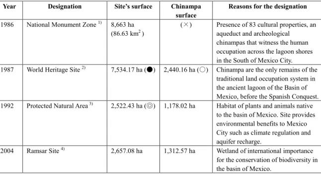
23 Another important aspect for understanding the study site’s characteristics is the presence of special designations for preserving chinampas. Some contents of special designations can be seen in Table 2-1. First, in 1986, the Mexican authorities designated the chinampas as part of a National Monument Zone to safeguard cultural properties in the south of Mexico City. In 1987, UNESCO listed chinampas as a World Heritage Site because of its ecological and cultural attributes. Afterwards, the Mexican authorities decreed the Natural Protected Area in 1992 to conserve the biodiversity of chinampas and the wetland. The Ramsar convention recognized chinampas as part of a wetland of international importance in 2004.
The multiplicity of designations denotes not only the ecological and heritage relevance that nationally and internationally chinampas have, but also, it illustrates the complexity that supposes the conservation of chinampas.
Table 2-1 Special designations for chinampas
Year Designation Site’s surface Chinampa surface
Reasons for the designation 1986 National Monument Zone 1) 8,663 ha
(86.63 km2 )
(×) Presence of 83 cultural properties, an aqueduct and archeological
chinampas that witness the human occupation across the lagoon shores in the South of Mexico City.
1987 World Heritage Site 2) 7,534.17 ha (●) 2,440.16 ha (○) Chinampa are the only remains of the traditional land occupation system in the ancient lagoon of the Basin of Mexico, before the Spanish Conquest.
1992 Protected Natural Area 3) 2,522.43 ha (◎) 1,178.02 ha Habitat of plants and animals native to the basin of Mexico. Site provides environmental benefits to Mexico City such as climate regulation and aquifer recharge.
2004 Ramsar Site 4) 2,657.08 ha 1,312.57 ha Wetland of international importance for the conservation of biodiversity in the basin of Mexico.
NOTES:
×Data not available; ●This data is as specified in the Master Plan for the World Heritage Site Xochimilco, Tlahuac and Milpa Alta by UNESCO in 2006. As mentioned in the chapter 1, the site is one part of the World Heritage Site Historic Center of Mexico City and Xochimilco. ○This surface includes the historic center of Mixquic village ◎This surface is after the modification of the Natural Protected Area boundaries in 2006 (See chapter 3)
The sites’ official names are indicated as follows: 1) Historic Monument Zone in the boroughs Xochimilco, Tlahuac and Milpa Alta, Federal District (Spanish: Zona de Monumentos Históricos en las delegaciones de Xochimilco, Tláhuac y Milpa Alta, D.F.) ; 2) World Heritage Site, natural and cultural, in the boroughs Xochimilco, Tlahuac and Milpa Alta (Spanish: Zona de Patrimonio Mundial Natural y Cultural de la Humanidad en las delegaciones de Xochimilco, Tláhuac y Milpa Alta); 3) Natural Protected Area for Ecological Conservation “Ejidos de Xochimilco y San Gregorio Atlapulco” (Spanish: Area Natural Protegida sujeta a proteccion ecologica “Ejidos de Xochimilco y San Gregorio Atlapulco” ) , and 4) Lacustrine System “Ejidos de Xochimilco y San Gregorio Atlapulco” (Spanish: Sistema lacustre “Ejidos de Xochimilco y San Gregorio Atlapulco” )