INVITED PAPER
Special Section on Satellite Communication Technologies in Conjunction with Main Topics of JC-SAT2011Research and Development on Satellite Positioning and Navigation in China ∗
Weixiao MENG†a), Enxiao LIU†, Shuai HAN†,Nonmembers,andQiyue YU†,Member
SUMMARY With the development of Global Navigation Satellite Sys- tem (GNSS), the amount of related research is growing rapidly in China. A lot of accomplishments have been achieved in all branches of the satellite navigation field, especially motivated by the BeiDou Program. In this pa- per, the current status, technologies and developments in satellite position- ing and navigation in China are introduced. Firstly, an overview and update of the BeiDou Program is presented, known as the three-step development strategy for different services. Then signal design for the BeiDou system is discussed, including the generation of pseudo-random noise (PRN) codes for currently available signal B1, and the investigation of a new signal mod- ulation scheme for interoperability at open frequency B1C. The B1C signal should comply to Multiplexed Binary Offset Carrier (MBOC) constrains, and a modulation called Quadrature Multiplexed BOC (QMBOC) is pre- sented, which is equivalent to time-multiplexed BOC (TMBOC) for GPS and composite BOC (CBOC) for Galileo, while overcomes the drawback of CBOC. Besides, the inter and intra system compatibility is discussed, based on the effectiveC/N0proposed by International Telecommunication Union (ITU). After that, receiver technologies in challenging environments are in- troduced, such as weak signal acquisition and assisted GNSS (A-GNSS).
Moreover, a method of ambiguity mitigation for adaptive digital beam forming (ADBF) in large spacing antenna arrays is proposed, by which interference suppression is available. Furthermore, cutting edge technolo- gies are brought in, including seamless navigation for indoor and outdoor, and collaborative navigation. After all, GNSS applications in China for industry and daily life are shown, as well as the market prospection.
key words: GNSS, BeiDou, MBOC, navigation receiver, signal design
1. Introduction
USA owns the earliest operating and currently the most successful Global Positioning System (GPS), and Rus- sia has completed the Global Navigation Satellite System (GLONASS) constellation, while European Union (EU) is carrying out the Galileo program. In recent years, China has been developing the BeiDou Project, which was planned in the 1990s. The current evolution is BeiDou-2, known as Compass [1]. The employments of GPS in the Gulf War and E911 policy of the federal government greatly drive the research and development of Global Navigation Satel- lite System (GNSS) in both military and civil areas all over the world.
The research activities in China mainly focus on the construction and applications of the BeiDou system. The
Manuscript received March 19, 2012.
Manuscript revised July 13, 2012.
†The authors are with the Communication Research Center, Harbin Institute of Technology, Harbin, China.
∗This paper was supported by The National High Technol- ogy Research and Development Program of China (863 Program) (2012AA120802)
a) E-mail: [email protected] DOI: 10.1587/transcom.E95.B.3385
BeiDou program consists of three steps [2]: BeiDou-1 was the first step and completed in 2003, officially called Bei- Dou Navigation Experimental System; in the second step, a regional navigation system for Asia-Pacific region is ex- pected by 2012, and it is a part of BeiDou-2; in the third step, BeiDou-2 is planned to be finished by 2020 and to pro- vide global navigation service. There have been more than 150 thousand registered users of BeiDou-1 in fishery and disaster relief applications so far, while BeiDou-2 is still un- der construction, in which the work related to modernization signal design plays an important role.
In 1999, USA announced the GPS modernization pro- gram, and indicated that two signals would be added for civil service: L2C and L5. In order to achieve interoperability with Galileo in L1 band, another modernization signal of GPS L1C was presented, which was modulated by Multi- plexed Binary Offset Carrier (MBOC) at 1575.42 MHz, as well as E1OS signal of Galileo [3]. Analogously, Compass proposed B1C signal modulated by MBOC in L1 band. In addition, Compass occupies the same frequency band with Galileo E5 in B2 band and the signals overlap in each other.
Thus, the GPS/Galileo/Compass radio frequency compati- bility (RFC) should be taken into account.
Aiming at challenging environments, various receiver and augmentation technologies have been investigated and assessed in China. Multipath, weak signal and barrage in- terference are typical causes which make conventional re- ceiver’s performance degradation or even out of work [4].
High performance receivers are needed to solve these prob- lems. Besides, assisted GNSS (A-GNSS) and seamless navigation are new challenging technologies developed in China, which will make daily life more convenient and there will be a huge pie for civilian service market in the future.
This paper presents the current research and develop- ment situations mentioned above in China. The remainder of this paper is organized as follows: in Sect. 2, the Bei- Dou program is introduced in detail, from the original plan to the future; in Sect. 3, the PRN codes generation for B1 signal of Compass is presented, and for open service sig- nal B1C, Quadrature Multiplexed BOC (QMBOC) modula- tion is described; in Sect. 4, receiver technologies studied in China are introduced, including some novel and advanced methodologies appeared in recent years; in Sect. 5, practical applications in fishery and disaster relief are presented, as well as the industry and market in future will be indicated;
Sect. 6 offers some concluding remarks.
Copyright©2012 The Institute of Electronics, Information and Communication Engineers
launch of BD-1C in 2003 meant the completion of BeiDou- 1 navigation system. The first two launched satellites were used for positioning and communication, and the third one was the backup, while the fourth launched in 2007 was for experiments in space, as well as a backup for the early three ones. BeiDou-1 is different from GPS or GLONASS, since it is a regional active navigation system with GEO satellites.
It contains three parts: Space Segment, Control Segment (Monitor Station), and User Terminal. When positioning is needed, the user transmits request signal to the satellites in L band, and the satellites relay it to Ground Control Station in C band, and then servers on ground calculate the position solution for the user, according to the known positions of satellites and ground station, as well as the relief map; after that, the position is sent to satellites and then broadcasted to remote terminals [5]. It is shown in Fig. 1.
Therefore, the receivers need no resolution and the satellites need no atomic clock. The architecture of re- ceivers and satellites is simplified. The satellites of BeiDou- 1 work as communication relays between remote terminals and ground stations. In addition, the ability of communi-
Table 1 Launches of BeiDou-1 satellites.
Satellite Lunch Data Orbit BD-1A 10/31/2000 GEO 59◦E BD-1B 12/21/2000 GEO 80◦E BD-1C 05/25/2003 GEO 110.5◦E BD-1D 02/03/2007 Supersync orbit
Fig. 1 BeiDou-1 system.
the capacity of total positioning request is limited at 540000 times per hour, and the satellite relay adds the time delay for real time movement. What’s worse, radio quiescence cannot be achieved, and that the remote terminal needs transmit sig- nal to satellites makes the receiver cost rise and portability lose, which is adverse to customers.
2.2 BeiDou-2 (2007–2012): Regional Navigation System Covering Asia-Pacific Area
Based on the experimental system BeiDou-1, BeiDou-2 pro- gram was designed as a global navigation system, and the communication band and navigation band are separated, thus the communication ability can be improved obviously.
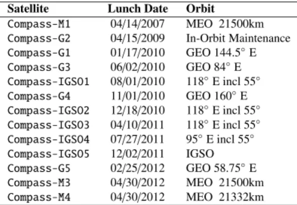
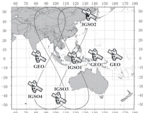
BeiDou-2, namely the Compass program, was planed in two stages: the regional navigation system covering Asia- Pacific area by 2012 and the global navigation system by 2020. The first step will be completed after 14 satellites launched, containing 5 GEO, 5 IGSO and 4 MEO satel- lites. There have been 13 satellites successfully launched for BeiDou-2 network so far, and 2 MEO satellites and 1 GEO satellite will be launched respectively in August and Octo- ber, 2012 [7]. The satellites launch information is shown in Table 2 and the trajectories of satellites in orbit by January 2011 are shown in Fig. 2. The launch of M3 and M4 is the first time China that has launched two navigation satellites with one rocket for BeiDou-2 program.
In this stage, there are three signal frequencies: B1, B2 and B3, all of which are modulated by Quadrature Phase Shift Keying (QPSK) [2]. The positioning and timing ser- vice accuracy is improved to 10 m and 50 ns, and the ve- locity accuracy is 0.2 m/s. B1 and B2 frequencies contain I and Q channels and I channels provide open service. China
Table 2 Launch of in-orbit BeiDou-2 satellites.
Satellite Lunch Date Orbit Compass-M1 04/14/2007 MEO 21500km Compass-G2 04/15/2009 In-Orbit Maintenance Compass-G1 01/17/2010 GEO 144.5◦E Compass-G3 06/02/2010 GEO 84◦E Compass-IGSO1 08/01/2010 118◦E incl 55◦ Compass-G4 11/01/2010 GEO 160◦E Compass-IGSO2 12/18/2010 118◦E incl 55◦ Compass-IGSO3 04/10/2011 118◦E incl 55◦ Compass-IGSO4 07/27/2011 95◦E incl 55◦ Compass-IGSO5 12/02/2011 IGSO Compass-G5 02/25/2012 GEO 58.75◦E Compass-M3 04/30/2012 MEO 21500km Compass-M4 04/30/2012 MEO 21332km
Fig. 2 Trajectories of BeiDou-2 satellites in orbit by January 2011.
Fig. 3 Compass global navigation system.
begun trial operations of BeiDou-2 on December 27, 2011 [8].
2.3 BeiDou-2 (2012–2020): Global Navigation System After 2012, the remainder satellites will be launched con- tinually to complete BeiDou-2 system by 2020, which will be a global navigation system containing 5 GEO, 3 IGSO and 27 MEO satellites in three types of orbits, shown in Fig. 3. Since GPS only contains MEO satellites, BeiDou- 2 could provide better performances in satellite availability and GDOP (Geometric Dilution of Precision) than GPS, es- pecially in Asia-Pacific area. While the far-near effect in- duced by different orbits needs to be corrected. Besides, the launch of GEO or IGSO satellite is more difficult and costly.
The positioning and timing accuracy will be 10 m and 20 ns for open service, and there will be differential signal to pro- vide 1 m accuracy positioning service [2].
The frequencies in B1 and B2 band will be adjusted during this phase. B1C signal will be added at frequency 1575.42 MHz, the same as GPS L1 and Galileo E1OS fre- quency, in order to implement interoperation with different constellations. As a result, the interoperation signal will be modulated by MBOC(1,6,1/11), the same as GPS L1C sig- nal and Galileo E1OS signal in frequency domain. B2 sig- nals will be all open service, modulated by AltBOC(15,10) at 1191.795 MHz, the same as Galileo E5 signals, which is the life and safety service channel [1].
Fig. 4 Ranging code generator of carrier B1.
3. BeiDou Signal Design and Assessment
In December 2011, China Satellite Navigation Office pub- lished the test version of BeiDou Navigation Satellite Sys- tem Signal In Space Interface Control Document (ICD) [9], in which the specifications of B1 signal at 1561.098 MHz was presented. The design of B1C signal is still under re- search, the realization in time domain has not been deter- mined until now, and in this section it will be discussed later, as well as the RFC of BeiDou system.
3.1 PRN Code Generation for B1 Signal
B1 signal carrier frequency is 1561.098 MHz, QPSK mod- ulated, ranging code rate and length of channel I is 2.046 Mcps and 2046 chips. The ranging code in channel I is a balanced Gold code sequence truncating the last one chip. The Gold code is generated by means of Modulo-2 addition of G1 andG2 sequences, which are respectively derived from two 11-bit linear shift registers. The generator polynomials forG1 andG2 are as follows [9]:
G1(X)=1+X+X7+X8+X9+X10+X11 (1) G2(X)=1+X+X2+X3+X4+X5+X8+X9+X11 (2) The initial phases ofG1 andG2 areG1: 01010101010, G2: 01010101010. The ranging code generator of carrier B1 is shown in Fig. 4.
The different phase shift of G2 sequence is accom- plished by respective tapping in the shift register which gen- eratesG2 sequence. By means of Modulo-2 addition ofG1 andG2 with different phase shift, a ranging code in channel I is generated for each satellite.
3.2 QMBOC Modulation for B1C Signal
With the modernization of GNSS, there are more signals in L1 band. RFC and interoperability become key issues for GNSS. On June 26 2004, USA and EU reached an agreement on sharing L1 band for interoperation. In 2006, Guenter W. Hein and John W. Betz recommended the opti- mized spreading modulation MBOC for Galileo E1OS and GPS L1C signals, instead of the previously proposed BOC
n×1.023 MHz. GPS L1C is defined in time domain as GMBOC(6,1,1/11)(f)=1
4GDate(f)+3
4GPilot(f) (4) GPilot(f)=29
33GBOC(1,1)(f)+ 4
33GBOC(6,1)(f) (5) GData(f)=GBOC(1,1)(f) (6) While Galileo E1OS signal is defined in time domain as
GMBOC(6,1,1/11)(f)=1
2GData(f)+1
2GPilot(f) (7) The subcarrier for both data and pilot channel is
sCBOC(t)=
10
11sBOC(1,1)(t)±
1
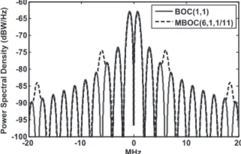
11sBOC(6,1)(t) (8) BOC(1,1) owns more high-frequency components than BPSK(1) spreading modulation of C/A code. As a re- sult, BOC(1,1) has better performances in code tracking and anti-multipath. By adding a small fraction of BOC(6,1) to BOC(1,1), MBOC(6,1,1/11) provides more components in higher frequency, as shown in Fig. 5, and it achieves better performances than BOC(1,1) [3], [10].
BeiDou-2 is developing a different modulation in time domain for MBOC(1,6,1/11), and QMBOC is one most rep- resentative modulation methodology.
QMBOC was proposed by Z. Yao et al. in 2010 [11], it was different from time multiplexing of GPS, either from spatial multiplexing of Galileo ˙QMBOC(m,n,γ) can be ex- pressed as
sQMBOC(t)=
1−γsBOC(n,n)(t)±j√γsBOC(m,n)(t) (9) It is similar to CBOC but different in multiplexing.
Component BOC(n,n) is modulated in phase quadrature with BOC(m,n), in order to eliminate the cross-term be- tween them in the autocorrelation, which appears in CBOC
Fig. 5 Power spectral density of BOC(1,1)and MBOC(6,1,1/11).
density of each individual component can satisfy the MBOC constraint.
3.3 QMBOC Correlation Receiver The received signal can be expressed as
sIF(t) = ARe
sQMBOC(t)c(t)d(t)ejωIFt
= Ac(t)d(t) 1−γsBOC(n,n)(t) cos(ωIFt)
−√γsBOC(m,n)(t) sin(ωIFt)
(11) Where Ais the signal amplitude,c(t)d(t) is the PRN code with modulated data andωIF is carrier angular frequency.
The noise term is omitted for simplicity. After received, sIF(t) is firstly multiplied by an in-phase (I) replica and a quadrature-phase (Q) replica of the carrier respectively, and then the signals are correlated with replicas of PRN code with a BOC(m,n) spreading symbol and with a BOC(n,n) spreading symbol, respectively, over a periodT referred to as the coherent integral time. Ignoring the frequency error, the outputs of the correlators can be expressed as
⎧⎪⎪⎪⎪⎪⎪⎪
⎪⎪⎨⎪⎪⎪⎪⎪
⎪⎪⎪⎪⎩
I1=A
(1−γ)RBOC(n,n)(Δτ)dcosφ−A
(γ)Rc(Δτ)dsinφ I2=A
(1−γ)Rc(Δτ)dcosφ−A
(γ)RBOC(m,n)(Δτ)dsinφ Q1=A
(1−γ)RBOC(n,n)(Δτ)dsinφ+A
(γ)Rc(Δτ)dcosφ Q2=A
(1−γ)Rc(Δτ)dsinφ−A
(γ)RBOC(m,n)(Δτ)dsinφ (12) WhereφandΔτrepresent the estimation errors of the car- rier phase and code phase respectively, andRcdenotes the correlation of PRN codes. The outputs of the correlators are then merged by the following rules:
⎧⎪⎪⎨
⎪⎪⎩I=
1−γI1+√γQ2=ARQMBOC(Δτ)dcosφ Q=√γI2−
1−γA1=ARQMBOC(Δτ)dsinφ (13) It is obvious thatIandQhave the same characteristic as traditional correlator outputs. As a result, traditional ac- quisition and tracking architectures can be employed subse- quently. Since the correlation functions have identical form, the correlation receivers of the QMBOC signal have the same performance as that of the TMBOC signal, while those of CBOC+and CBOC−have different properties, owing to the effect of vestigial cross-term. The correlation receiver of QMBOC signals is shown in Fig. 6. For simplicity, correla- tors corresponding to only one PRN code phase are shown,
and the structures after correlation value combination are omitted. Although the number of correlators in QMBOC receivers is twice as that in TMBOC and CBOC correlation receivers, the complexity introduced by the time multiplex- ing switch or the multilevel multiplication-accumulator is never a concern in QMBOC receivers. When matched re- ceiving, QMBOC has the same performance with TMBOC.
3.4 Assessment of RFC
RFC has become a matter of concern in GNSS filed since multiple systems such as GPS, Galileo and Compass are go- ing to serve in the same band [1], [12]. Some methodolo- gies for GNSS RFC analysis have been developed in order to investigate intra- and inter-system interference. Spectral separation coefficient (SSC)and effectiveC/N0proposed by ITU (ITU-RM) [13] are most popular. SSC indicates the correlation between spectrum overlapping signals, and it is affected by signal modulations, center frequencies,T x and Rxbandwidths [14]. While effectiveC/N0takes other sig- nals as noise and evaluates the effect to the expect signals.
In this paper, effectiveC/N0is employed, and together with the degrations induced by intra- and inter-system in- terference are summarized in Table 3, including B1C signal and B2 civil signals of Compass. We can conclude that, in the E1-L1-B1 band, the inter-system interference from GPS
Fig. 6 QMBOC receiver structure.
Table 3 The effectiveC/N0and degration of BeiDou-2.
Interference condition
E1-L1-B1 E5-L5-B2
(C/N0)eff
Degration of (C/N0)eff
(C/N0)eff
Degration of (C/N0)eff
Thermal nosie 45.40 dBHz - 42.89 dBHz - Intra-system
interference 44.62 dBHz 0.78 dB 42.18 dBHz 0.71 dB Inter-system
interference from Galileo
44.19 dBHz 0.43 dB 41.49 dBHz 0.69 dB Inter-system
interference from GPS
43.31 dBHz 1.31 dB 41.75 dBHz 0.43 dB Inter-system
interference from GPS and
Galileo
42.98 dBHz 1.63 dB 41.12 dBHz 1.07 dB
is higher than that from Galileo. In the E5-L5-B2 band, the inter-system interference from Galileo is higher than that from GPS. The total inter-system interference in E1-L1-B1 band is higher than that in E5-L5-B2 band. While Compass induces more degration to GPS and Galileo in L1 band than that they do to Compass, owing to the GEO satellites princi- pally, yet the degrations are all within an acceptable range.
4. Receiver Technologies
When China is developing the autonomous BeiDou system, GNSS receiver technologies are studied simultaneously. Be- cause GPS was designed early and some disadvantages were not considered enough, which made it imperfect, various of receiver and augmentation technologies are investigated to keep GPS working in challenging conditions [4]. The gen- eral interests in China will be introduced as follows.
4.1 Weak Signal Acquisition
The study on this subject is mainly based on coherent in- tegration, incoherent integration, difference algorithm, full- bits method, half-bits method, and so on. An improved dif- ference coherent integration algorithm can increase the co- herent integration time and reduce the square loss by esti- mating the combination of the product of adjacent naviga- tion data bits, which induces a long time coherent integra- tion can be used in difference algorithm. With the increase of data length accumulation, superiority of the new method is more significant, comparing with the full-bits and half- bits methods, and detection probability could achieve 96%
withC/N0=20 dB-Hz and data length=160 ms [15], which can be drawn from Fig. 7.
4.2 Assisted GNSS
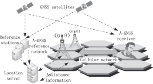
For urban users suffering shading and multipath interfer- ence, assisted GNSS is proposed. The architecture is shown in Fig. 8. A-GNSS receiver gets assistance information by cellular network from reference stations and location server.
According to the difference of assistance approach, it can be defined as MS-assisted or MS-based [16], where MS de- notes mobile station, namely the GNSS receiver, and in for-
Fig. 7 Detection probability with data length of 160 ms.
Fig. 8 Asissted GNSS architecture.
mer case the position is calculated by server while in the latter case it is calculated by the receiver itself.
4.3 Interference Suppressing
To combat against malicious interferences, antenna ar- ray with ADBF (adaptive digital beam forming) or STAP (space-time adaptive processing) has been indicated to be an effective technology. Various algorithms have been pro- posed in the past to demonstrate the effectiveness of such method, while the antenna array is requested to be uni- form and half wavelength spacing, and the algorithms are not available in irregular or large spacing array, which is inconvenient. Novel array processing techniques could be potentially employed to combine the signals incident on the multiple antenna elements, and process them coherently to achieve interference reduction.
When elements spacing is greater than 0.5λ, the prob- lem to find DOA of a signal is to resolve the inherent ambi- guities in the estimation process. Once the DOA is known, location of the emitter can be performed, and modified null- steering beamforming techniques can be used to reduce the amplitude of signals in the interference directions [17].
There is a method based on double frequency to resolve the ambiguity [18]. Assume the phase differences measured between two nodes are Δζ1for L1 frequency and Δζ2 for L2 frequency respectively,Δζ1andΔζ2 belong to range of (−π, π). Then the real phase differences can be written as Δζ1+2n1πandΔζ2+2n2π, in whichn1 andn2 denote the unknown ambiguous period. The distance differences ex- pressed by L1 and L2frequency are the same, therefore
ΔS =Δζ1+2n1π
2π ·λ1= Δζ2+2n2π
2π ·λ2 (14)
Whereλ1andλ2are wavelengths of L1 and L2 frequency re- spectively,n1andn2are integer and have the same symbol.
BecauseΔS is smaller than the distance between nodes, that n1andn2have ambiguous values is an event of small prob- ability. After ambiguity resolved the interference is sup- pressed and position is calculated.
In Fig. 9 and Fig. 10 the simulation results are shown, assuming that there are 7 antennas distributed with a spacing from 30 m to 50 m randomly on a plane. For conventional ADBF, the large spacing introduces grating lobe, and the
Fig. 9 Contour pattern without ambiguity resolved.
Fig. 10 Contour pattern after ambiguity resolved.
beam pattern is orderless. The star points are interference di- rections, while the peaks and nulls cannot be distinguished.
After the ambiguity resolved, it can be seen that the nulls and interference directions are clear, and the nulls mostly lie near to the directions of interference and the interference can be suppressed effectively.
4.4 Seamless Indoor and Outdoor Positioning
For indoor positioning the power of satellite signal is too weak to be acquired by the receiver, thus an alternative system is needed to provide navigation service for indoor users. Concerning about the cost of constructing a new sys- tem, the existing communication network is considered as the solution, such as WLAN and UWB, which are broadly installed at school and shopping mall. Based on these net- work, cell ID, TOA (time of arrival), TDOA (time difference of arrival), DOA, fingerprint and fuzzy logic algorithms are widely investigated for indoor navigation.
Positioning for indoor and outdoor employs different system respectively, thus switches are needed for users when going through between indoor and outdoor, which would make receivers more complex and discontinuity. Therefore, seamless indoor and outdoor positioning methods are inves- tigated and most are focused on handover methodologies. A novel methodology based on finger print algorithm is pro- posed, as shown in Fig. 11. The indoor transmitters employ the same carrier and PRN code series with those of outdoor GNSS, so the indoor receiver could be the same as that of outdoor and little changes needed in software [19]. Com- bining with finger print algorithm, the indoor positioning
Fig. 11 Seamless indoor and outdoor navigation.
accuracy could be better than 2 m. The handover between indoor and outdoor achieves real seamlessness since there is no difference in navigation signal acquisition and tracking.
4.5 Collaborative Navigation
Thanks to GPS fast development, the number of users rises rapidly. As a result, the GPS users are dense in urban area, which can implement collaborative navigation to improve single receiver performance in challenging environments.
Literature [20] presents the collaborative satellite navigation concept and approach for robust GPS positioning in a dy- namic sensor network using a distributed aperture and RF ranging signals among the network nodes.
5. Applications and Market
5.1 BeiDou Applications in Industry and Daily Life
• Fishery command and monitoring system. In 2011, the fishery command center and fishery boats applica- tions project was finished in Hainan Province by BD- Star Navigation Co., Ltd and proved admission. It is the largest civilian promotion project so far for BeiDou system, and is supported by Ministry of Agriculture.
This dispatch system provides services in South China Sea first, and then will be extended to deep-sea fishery boats in East China Sea, Yellow Sea and Bohai Sea, and has more than ten thousand onboard users. It consists of one Operation&Service Center, two Master Monitor Stations and tens of Center Stations, providing services for thousands of fishing boats.
• Disaster prevention and relief. After earthquake hap- pened in Wenchuan of Sichuan Province and Yushu of Qinghai Province, BeiDou terminals sent the disaster and rescue information to command center timely, as the only available communication system at that time.
More than one thousand terminals were equipped with rescuers in Wenchuan, and they provided more than 1.64 million times positioning and 740 thousand times short message service [21]. In addition, the Three Gorges hydrology monitoring system based on BeiDou was employed around Barrier Lake to collect and trans- mit information about flood situation to command cen- ter with 125 automatic terminals, and the prevention work kept the disaster victims downstream safe when flood discharging.
Fig. 12 Projected GNSS sales of China for 2005–2025.
5.2 Market Development
As a result of the development and applications of BeiDou system as well as other GNSS, the navigation market grows rapidly in China [22]. Figure 12 shows the sales projection of GNSS in China, from 2005 to 2025. It can be drawn that applications grows slowly after 2010, while services will de- velop faster and exceed applications.
6. Conclusions
In this paper, the situation of research and development on GNSS in China is introduced, together with applications and technologies status. As the national strategy, BeiDou is be- ing constructed smoothly, and BeiDou-1 has been widely applied in different fields for production and daily life ser- vice, such as fishing boats monitoring system, the largest civilian promotion project of BeiDou.
With the development of GNSS, the market in China has been growing rapidly for years, and mobile users and service sales will grow faster than ever in the future. Though in China the share of BeiDou in GNSS market is less than 1%, due to the bottleneck of chip manufacture, it will ex- plode after breakthroughs in chip fabrication and the intro- duction of BeiDou-2. China is definitely pushing the GNSS industry forward.
References
[1] Office for Outer Space Affairs of the United Nations, Current and Planned Global and Regional Navigation Satellite Systems and Satellite-based Augmentations Systems, June 2010.
[2] China Satellite Navigation Office, Development of BeiDou Naviga- tion Satellite System, Sept. 2011.
[3] G.W. Hein, J.-A. Avila-Rodriguez, S. Wallner, A.R. Pratt, J. Owen, J.-L. Issler, J.W. Betz, C.J. Hegarty, L.S. Lenahan, J.J. Rushanan, A.L. Kraay, and T.A. Stansell, “MBOC: The new optimized spread- ing modulation recommended for GALILEO L1 OS and GPS L1C,”
Proc. IEEE/ION Position, Location, And Navigation Symp, pp.883–
892, 2006.
[4] D. Last, “GNSS: The present imperfection,” Inside GNSS, 2010.
[5] S. Dai, C. Ma, and J. Liao, “Analysis and research of Beidou I nav- igation position system,” Computer & Digital Engineering, vol.3, pp.57–59, 2010.
[6] C. Cao, G. Jing, and M. Luo, “Compass satellite navigation sys- tem development,” ‘PNT Challenges and Opportunities’ Sympo- sium, Standford University, Nov. 2008.
[7] “Report on the development of BeiDou (COMPASS) navigation satellite system,” Tech. Rep., China Satellite Navigation Office, Dec.
no.17, pp.1234–1236, 2010.
[12] R. Liu, Y. Chen, and L. Yu, “Analysis of performance and simulation for compass,” 2nd China Satellite Navigation Conference, Shanghai, China, May 2011.
[13] The ITU Radiocommunication Assembly, A coordination method- ology for RNSS inter-system interference estimation, Rec. ITU-R M.1831 ed., 2007.
[14] W. Liu, C.R. Zhai, X.Q. Zhan, and Y.H. Zhang, “Assessment and analysis of radio frequency compatibility among several global nav- igation satellite systems,” IET Radar, Sonar & Navigation, vol.5, no.2, pp.128–136, 2011.
[15] W. Meng, R. Ma, and S. Han, “Optimum path based differential coherent integration algorithm for GPS C/A code acquisition un- der weak signal environment,” Proc. First Int Pervasive Computing Signal Processing and Applications (PCSPA) Conf., pp.1201–1204, 2010.
[16] F. van Diggelen, A-GPS: Assisted GPS, GNSS, and SBAS, Artech House, 2009.
[17] D. Wilson and S. Ganguly, “Development of an A/J system using available antennas,” Proc. ION GNSS 2007, pp.25–28, Sept. 2007.
[18] W. Meng, E. Liu, and S. Han, “A novel collaborative naviga- tion architecture based on decentralized and distributed Ad-hoc networks,” IEEE International Conference on Communications, Ottawa, Canada, June 2012.
[19] D. Manandhar, K. Okano, M. Ishii, H. Torimoto, S. Kogure, and H. Maeda, “Development of ultimate seamless positioning system based on QZSS IMES,” Proc. ION GNSS 2008, pp.16–19, Sept.
2008.
[20] D.A. Grejner-Brzezinska, C.K. Toth, L. Li, J. Park, X. Wang, H.
Sun, I.J. Gupta, K. Huggins, and Y.F. Zheng, “Positioning in GPS- challenged environments: Dynamic sensor network with distributed GPS aperture and inter-nodal ranging signals,” Proc. GNSS 2009, Savannah International Convention Center, Savannah, GA, pp.111–
123, Sept. 2009.
[21] Y. Zhu and Z. Bai, “The Compass communication system and its applications,” 2nd International Conference on Future Computer and Communication, May 2010.
[22] C. Liu, H. Yang, and C. Hu, “Analyzing the standardization and in- dustrialization of Compass navigation satellite system,” 2nd China Satellite Navigation Conference, Shanghai, China, May 2011.
book and over 150 papers for journals and international conferences. He is the Chair of IEEE Harbin Section Communications Society Chapter, a senior member of the IEEE and IET, the China Institute of Electronics, the China Institute of Communication, and Expert Advisory Group on Harbin E-Government. He has been an editorial board member for Wiley’s WCMC Journal since 2010.
Enxiao Liu received his bachelor of sci- ence from Mathematics Department, and master of engineering in Information and Communica- tion Engineering from School of Electronics and Information Engineering, HIT in 2007 and 2009 respectively and currently is a Ph.D. candidate in School of Electronics and Information Engi- neering, HIT. His main activities are currently in adaptive antenna array, interference suppressing for GNSS.
Shuai Han received his B.S., M.S., and Ph.D. degrees from School of Electronics and Information Engineering, HIT in 2004, 2007, and 2011 respectively. He is currently a lec- turer at the Department of Communications En- gineering, HIT and is a post-doctoral fellow with Engineering and Applied Science Memo- rial University, Canada. His main activities are currently in signal propagation and GNSS re- ceiver development.
Qiyue Yu received her B.S., M.S., and Ph.D. degrees in communications engineering from HIT in 2004, 2006, and 2010 respectively.
Currently she is a lecturer at the Department of Communications Engineering, HIT. During April 2007–March 2008, she studied in Adachi Lab, Tohoku University, and was a research as- sistant of Tohoku University Global COE pro- gram. Her research interests include modulation and coding, multi-access techniques and MIMO for broadband wireless communications.