organization of urban space in Manchuria (Part I)
journal or
publication title
The Social Science(The Social Sciences)
volume 43
number 3
page range 35‑56
year 2013‑11‑30
権利(英) Institute for the Study of Humanities & Social Sciences, Doshisha University
URL http://doi.org/10.14988/pa.2017.0000013354
Imperial Expansion, Human Mobility and the Organization of Urban Space in Manchuria (Part I)
Rosalia AVILA-TAPIES
Since the late XIX century, the former territory of Manchuria became one of the greatest migration grounds of the world and the most important overseas destination for the Japanese. In the context of a renewed scholarly interest in Japanese imperialism, especially from a social and cultural perspective, we will reflect herein on the geopolitical structures and the distribution of power in the Manchurian geographical space, its dynamism and its socio-spatial consequences on a global (Manchuria) and micro (the Japanese settlement at Mukden) scale. We shall consider three important processes working simultaneously: empire-building, human mobility and urban development, which would drastically transform the Manchurian space in the first half of the XX century.
Keywords: imperialism, migration, urbanization, Manchuria, Mukden.
旧満州における帝国の拡大,人口移動および都市空間構造について
(上
)19 世紀後半以来,旧満州は世界最大の人口移動地域の一つとなり,日本人にとって 最も重要な海外移動目的地となった。日本の帝国主義に新たな学術的関心という文脈 の中から,特に社会・文化的視点から,満州内の地政構造と権力の分布,およびグロー バル(全満州)とミクロ(奉天の日本居住地)なスケールで見られるダイナミズムと その社会的空間的な影響を検討する。20 世紀の前半に満州の空間を変換させ,連結し ている 3 つの重要なプロセスである帝国構築,人口移動,都市開発について考察する。
キーワード:帝国の拡大,人口移動,都市化,満州,奉天
1 Introduction
Since the late nineteenth century, Northeast China was the scene of Chinese, Russian and Japanese rivalries for the control of this frontier region, known as the
ʻThree Eastern Provincesʼ (Tung-san-sheng) by the Chinese, and as ʻManchuriaʼ by
Westerners and the Japanese. The unequal power relations between imperial China and the two dominant East Asian powers at the time, Czarist Russia and the Japanese empire, made possible the Russian and Japanese penetration in Manchuria and the acquisition of leaseholds and concessions. This way, after the Russo-Japanese War (1904-1905) and through the terms of the Treaty of Porthmouth (1905), Manchuria fell into two distinct spheres of influence, organized around railway corridors: the Russian in North Manchuria and the Japanese in the South.
This Russian and Japanese economic penetration and political expansion in Manchuria, which historian Peter Duus has called ʻconcession imperialismʼ (Duus, 1995:11)1), entailed important long-lasting demographic and territorial impacts on the territory. This initiated a large-scale immigration ―mainly from the North of China, but also from Korea, Japan and other adjacent areas― into the region, which blossomed after the development of new railway technology. Moreover, it contributed to the urban growth and the foundation of new rural and urban population centres, which became the preferred settlement locations of the colonizers and were originally planned to be the instruments of domination and control of the rest of the territory.
In the context of a renewed scholarly interest in Japanese imperialism, especially from a social and cultural perspective (Asano, 2005), we will reflect herein on the geopolitical structures and the distribution of power in the Manchurian space, its dynamism and its socio-spatial consequences on a global (Manchuria) and a micro (the Japanese settlement at Mukden) scale. Focusing on geographic distribution and spatial differentiation, we shall consider three important processes working simultaneously: empire-building, human mobility and urban development, which would drastically transform the Manchurian space in the first half of the twentieth century.
2 Empire as a spatial construct
As Yang states, empire-building is a project of producing and constructing imperial space. Therefore, it becomes a spatial construct (Yang, 2010:3). Russian and Japanese
empire-building since the late nineteenth century were not an exception to this rule, as demonstrated by their encroachment in Manchuria. Competitively, and to fulfil the dreams of a Far Eastern Empire (Russia) or a greater Empire (Japan), these imperialist Powers pressed China for exclusive economic and political rights in Manchuria such as: concessions of territories, construction rights and extraterritorial privileges in her territory. Thus, through leaseholds and treaty concessions granted by the government of China, first, the Russians and later, the Japanese were able to expand their hegemony in the territory until the founding of Manchukuo (1932), when Japan increased its power over the totality of the territory.
Among these concessions, the railway construction rights, derivable from the Sino- Russian railway contract agreements of 1896 and 1898 for the construction of the Chinese Eastern Railway (Young, 1931:79), became extremely important for the subsequent territorial control and economic exploitation of Manchuria by these two foreign Powers (Chou, 1971). The Russians built the Chinese Eastern Railway (CER) across northern inner Manchuria, and its southern branch ―the Japanese- reorganized South Manchuria Railway (SMR) from Changchun to Port Arthur― and its expansion (the Mukden-Antung line) were operated by two private joint stock railway companies: the Chinese Eastern Railway Company (established in 1898)2) and the South Manchuria Railway Company (established in 1906). Both of them initially possessed identical international legal rights granted by the government of China and were subject to extraterritoriality. They were different from other railway companies financed by foreigners in the rest of China, where no rights were granted to police the line or to establish municipal administration along its right of way (Young, 1931:100). With a controlling influence reserved for the Russian and Japanese governments, respectively, they were, in fact, semi-official institutions that managed to monopolize vital productive sectors through which they were able to control foreign Manchurian trade. With this, the CER and the SMR came to be the centre of all political and economic activities in Manchuria, both domestic and international (Wang, 1933:57). However, the railway system of Manchuria seemed to have been built primarily not for economic consideration but for political and strategic purposes (Grajdanzev, 1945:329; Chou, 1971:81; Matsusaka, 2001). For this reason, it can be said
that these railway companies were not simple business enterprises seeking to maximize their profits but also the instrumental arm of the foreign powers to extend their spheres of influence (Chou, 1971:58).
Over time, and as a result of Russia and Japanʼs application of railway technology in empire-building, the railways were capable not only of contracting distances and unifying and expanding markets, but also of reshaping the political and cultural geography of Manchuria. They practically determined the patterns of migration and settlement, and came to be the instruments of empire-building by directing the vectors of development (Matsusaka, 2001:62,70). The Russian ―and Japanese―
controlled railway systems symbolized the colonial conquest by railway, as they functioned as ʻengines of growthʼ and ʻterritorial powersʼ (Matsusaka, 2001:62), making Manchuria an example of a space manipulated by a (colonial) power in order to serve their interests (Sánchez, 1981).
2.1 The main agency of Japanese expansionism
During the pre-Manchukuo period, the Japanese advance in Manchuria was based on the leasehold concessions and rights inherited from Russia according to the Treaty of Portsmouth (1905), and it was limited to the Kwantung Leased Territory at the southern tip of the Liaotung peninsula; the SMR commercial right of way, and the railway lands (the South Manchuria Railway Zone, actually, a concession territory).
The company operating the railway, the South Manchuria Railway Company (hereafter SMR Company), also popularly known as Mantetsu, then became the main agency of Japanese penetration and colonialism in Manchuria prior to the establishment of Manchukuo.
The SMR Company was established in 1906 and began its operation in 1907. It was modelled to a great extent after the CER, claiming the same jurisdictional rights in Manchuria. However, it had much less Chinese participation than in the CER3). The Japanese government owned one-half of the shares of the capital stock, and the rest were widely distributed in Japan. No shares were ever purchased by the Chinese government (Young, 1931:84-85). Thus, the SMR Company was ʻcreated by, responsible to, and subject to change or abolition by, the Japanese governmentʼ (Young, 1931:83). It
was a Japanese-operated, far more important and efficient commercial enterprise than the CER (Young, 1931:98-99). It became the largest enterprise in Manchuria, ultimately controlling most of Manchuriaʼs rail traffic and its general economic life in the first half of the twentieth century.
The SMR Company was organized under Japanese law, with private commercial and public functions derived from the Japanese government, comprising not only the management of the railways, which constitute its main business, but also the operation of mines, harbours and wharves, water transportation systems, electrical enterprises, warehousing, real estate business in the railway lands, and the sell-on- commission of the principal goods carried by the railways. Moreover, it was given complete charge of the development and administration of public utilities within the railway lands, being responsible for engineering works, education, sanitation and scientific experimentation in agriculture and industry in these municipality areas under its administration (Young, 1931:80-82; SMR Co., 1936:68).
2.2 A territorial power
The SMR Company operated in the leased South Manchuria Railway Zone (hereafter, SMR Zone), transferred from Russia by the terms of the Treaty of Portsmouth and subject to extraterritorial rights4). The SMR Zone was a narrow strip of land on either side of the railway track, enlarged around station areas, which became an axis of Japanese activities and colonization in Manchuria (Matsusaka, 2001:70). With quite an irregular form, its extent was expanded over time, from 184
km² in the year 1908 to 524 km² in 1936 (Minami Manshû Tetsudô, 1939:33), including important municipalities and lands used for coal and iron mining. The SMR Zone was directly administrated by the SMR Company that urbanized it around major stations, raising numerous regulated cities to serve as residential and business activity centres for the new settlers (preferably), under the privilege of extraterritoriality.
This way, as the Russians had done before, SMR Company transformed the main stations of the SMR into new urban hubs under foreign jurisdiction and administered by the company. The cities were planned and built following contemporary Japanese technological and building patterns. These cities were usually built in a flat and
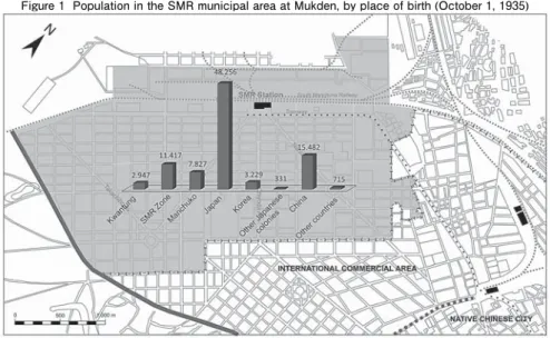
uniform urban vacuum, near a place that was previously occupied. They became a technologically advanced regulated urban space, with schools, ʻand hospitals and parks and playgrounds and waterworks and electric light and power plants, sewage and other sanitary systemsʼ (Adachi, 1925:131). Among these new urban areas, notable for its size and importance, was the Mukden railway town (see figure 1), whose geopolitical structures and socio-spatial patterns we will analyse later.
These railway towns were like a showcase of the Japanese rule in Manchuria, a reflection of the colonizersʼ power and prestige, specifically designed to accentuate the differences with their environment (Avila, 2012). They were outside of the Chinese traditional order, and opposing it to the modern colonial power (as if denying any pre- existent culture). They ʻcame to symbolize Japanʼs colonial modernityʼ (Yang, 2010:50), the instrument of Japanese power in Manchuria and result of an empire-building strategy.
3 Populating the Manchurian space
As already noted, Russian and Japanese expansionism in Manchuria was accompanied by great population movements from North China, Korea, Japan and
Figure 1 Population in the SMR municipal area at Mukden, by place of birth (October 1, 1935)
Source: Kwantung, Kantô-kyoku (1939) Kokusei chôsa kekka-hyô, Shôwa jûʼnen, Kantô-kyoku hen.
Table 13.
other adjacent territories, and, equally important, from rural areas to the cities.
Migration was a ubiquitous phenomenon in Manchuria. Various types of international and domestic migration were taking advantage of Manchuriaʼs agricultural possibilities and the new economic opportunities created mainly by foreign capital investments. These massive international and rural-urban population movements were an essential component of the processes of structural change in Manchuria during this period. However, the opportunities were unequally distributed in space, in part because Russia and Japan had shifted the location of economic activity and trade mainly to their railway lands. Thus, settlement patterns became closely linked to the emerging colonial economy.
3.1 Manchuria as a ʻdemographic frontierʼ
Despite Manchuriaʼs long historical contacts with China proper, it had remained sparsely populated until the late nineteenth century (Ho, 1967:158). It was a frontier region that the Chinese started populating in large numbers at the end of that century, just after the last official restrictions on Chinese immigration were lifted by the Manchu court, and it started to be encouraged for defensive purposes. The new Russians settlements in the territories along the Amur river, and the foreign pressure on China contributed to the reversal of the north-eastern frontier policies. But it was the opening of the railways that ʻgave colonization a dynamic expansive characterʼ (Lattimore, 1934:97,99-100)5) accelerating the northward movement of Han Chinese. As a result, a preliminary official enumeration of the imperial Chinese government in 1907 placed the population of the ʻThree Eastern Provincesʼ (Fengtien, Kirin and
Heilungkiang) at slightly less than 15 million, with more than one half living in the southern province of Fengtien (modern Liaoning province). As this preliminary population count excluded some counties newly created by the new era of civil administration, and there were no figures for the Manchu population in Fengtien province or for part of the Korean immigrants, this total count of 1907 was necessarily incomplete. Most probably, the estimation of 17 million for 1904 made by the British consul at Newchuang, Sir Alexander Hosie, was nearer the truth (Ho, 1967:160-161).
By 1930, the Research Bureau of the SMR Company estimated the total population of
Manchuria at 34.3 million (Ho, 1967:163; Pan and Taeuber, 1952:95-96). In October 1, 1940, the total population had reached 43.2 million, according to the first census of
Manchukuo. Therefore, in forty years, the total population of Manchuria almost tripled, becoming the ninth largest population in the world.
At the end of the colonial period, the most densely populated region in Manchuria- Manchukuo was a wedge in the centre, based on the southernmost areas of the SMR- served South Manchuria, and extending upward through Kirin province to the junction of the North Manchuria and South Manchuria railways in Pinkiang Province. This highly populated region contained 22.6% of the area of Manchukuo and 63.7% of its population (Taeuber, 1945:265).
The aforementioned remarkable population increase during the first half of the twentieth century was due mainly to immigration from China proper, Korea, and the colonial core states, especially Japan, which made Manchuria a ʻgreat migration ground of eastern Asia and central Asiaʼ (Lattimore, 1932:177).
3.2 The Chinese immigration
Economic developments and scarcity of labour in Manchuria soon attracted Chinese labour immigration from south of the Great Wall, especially from the provinces of Shantung and Hopei, affecting first the nearest Jehol province and South Manchuria. But with the building of railways, Chinese penetration became different in character and expansion, involving more people and longer distances. As a result, this Han Chinese migration to Manchuria is considered one of the greatest movements of people in modern times, resulting in the conversion of an ethnically Chinese Manchuria, when the Han Chinese population reached 36.8 million on October 1, 1940, representing 85.2% of the total Manchukuo population.
Chinese migration could be essentially divided into two types: an agriculturalist migration for land settlement (settlers), and a long-term temporary migration (ʻcircular migrationʼ). The latter was composed mainly of young males migrating to the cities of the central plains and districts of new industrialization, attracted by the new opportunities opened in Manchuria by the railways and modern exploitation.
They would have been driven by the situation of cumulative disasters (Lattimore,
1932:185) found in the low plain provinces of North China, in contrast to the
abundance, relative peace, and political stability in Manchuria. Moreover, the railway and steamship companies helped to facilitate the movement by offering cut rate fares or even free passages to these Chinese labourers (Ho, 1967:161).
Our knowledge proceeds from inferential evidence, because the statistics on Chinese immigration into Manchuria are very few prior to 1923, when the Economic Research Department of the SMR Company began the publication of an annual series of estimates on migration to and from Manchuria (including the Kwantung Leased Territory) (Taeuber 1945:261; SMR Co., 1936:121-125,170-171). According to these records6), Han Chinese immigration to Manchuria passed the million mark during 1927, 1928 and 1929. Since 1930, however, it gradually declined and reached a new low
mark of 414,034 in 1932 and a negative migration rate, reflecting the political turmoil in Manchuria and the new Manchukuo state attempts to control and limit Chinese immigrants. However, these official figures on Chinese immigration are believed to be understatements (Taeuber, 1958:193). The effective control of Chinese mass migration to Manchuria was finally achieved in 1935, resulting in a decrease of the number of Chinese labourers entering Manchukuo. However these restrictions were eased in 1937 as a consequence of the inauguration of the ʻFive-year plan of industrial
development of Manchuriaʼ (1937-1941) and the need for Chinese labourers (Ladejinsky, 1941:317-318). The exigencies of wartime economy forced Manchukuo to admit a large number of Chinese workers and as a result, during 1942-1944, annual Chinese immigration into Manchuria exceeded 1 million people. The majority of the Chinese immigrants during 1938-1945 were employed as construction workers, miners or road builders (Grajdanzev, 1946:6). In total, and according to a more recent research on this topic, it is estimated that about 25.4 million immigrants entered Manchuria from North China during the 1891-1942 period, and approximately 34 % of them remained (Gottschang, 1987:180).
3.3 The Korean immigration
The second largest important immigration to Manchuria came from the Korean peninsula that was formally incorporated into the Japanese Empire in 1910.
Immigration from North Korea to the Manchuria-Korea border regions for agricultural settlement (ʻspontaneous frontier migrantsʼ) occurred at an early stage, and in some provinces like Chientao, the Koreans outnumbered the Chinese, having created ʻan ethnically homogeneous Korean area within a Chinese regionʼ (Taeuber, 1950:286). However, the more noticeable waves of migrants, seeking employment
mostly in agriculture, occurred after the establishment of Manchukuo. It was estimated that there were 53,000 Korean residents in Manchuria in 1910, and immigration grew steadily until reaching 662,000 in 1935 (SMR Co. 1936:125-129) and 1.45 million in 1940 (42.5% of them living in Chientao province). In the latter year, 70% of the Korean residents in Manchukuo were foreign born. Hence, Korean
immigration was mostly a recent immigration of Japanese imperial subjects. They moved away from the border regions in an overflow migration pattern into opposite directions: the more industrialized South and the ʻdeepʼ North along the CER lines.
This expansion into overall Manchuria was encouraged by Japan under subsidized farm-settlement plans for Koreans already in Manchuria and for those in the Korean peninsula (Yoda, 1984), mainly because the Koreans were rice growers, a product in high demand by the Japanese colonizers. As reported by Lee, their mobility was high and their standard of living was low because of the difficulties related to the leasing and purchasing of lands (Lee, 1932), as was the case of other foreigners in Manchuria under the Chinese government rule7).
3.4 The Japanese immigration
The third largest immigration movement was that of the Japanese. The Japanese civilians calculated on October 1, 1940, numbered 819,614. However 46.8% of Japanese men over 21 years of age had an army or navy ʻservice relationshipʼ, even though they were not in or attached to the armed forces at the time, and the group of men in the conscript age (21-25) was much smaller than expected, indicating the close relationship between the flows of military personnel and civilians for the Japanese migrations (Taeuber, 1958:194).
According to the statistics of the movement of passengers by sea in the three ports of the Kwantung Leased Territory, 2.8 million Japanese entered Manchuria during
1906-1942. Of these, only 568,238 remained (20.3%), showing a total return ratio of
79.7% for the entire period (Avila, 2002:39)8). It was primarily young male migration from western Japan (particularly from Kyûshû), almost constantly increasing with a significant peak at the end of the second decade of the twentieth century (economic boom in Manchuria) and since the creation of Manchukuo, which reached an annual inflow of more than 200,000 in the years 1939, 1940 and 1941, and began a definitely a sharp decline thereafter, once the Pacific War had begun. The immigration data show that immigration levels were closely related to the growth of economic opportunities in Manchuria. People mainly migrated to the cities and within the orbit of Kwantung and the SMR Zone, enjoying a high economic status.
After creating Manchukuo, the Japanese settled throughout Manchukuo, but they still mostly preferred the urban areas. As reported by the Population Statistics of Residents in the Manchukuo Empire, 71.5% of the Japanese were living in the 15 largest cities in the year 1937, but this proportion had dropped to 63.9% in 1941 due to the organization of Japanese government-sponsored colonization programs. Under these programs, 220,359 Japanese agricultural colonists, and 101,514 Youth Volunteer Corps or apprentice settler corps for the colonization of Manchukuo9) (Manshû Kaitaku Shi Fukkan Iinkai, 1980:465; Araragi, 1994:59) were sent to North Manchuria, in the vast areas opened up for Japanese immigration, with the military and political objectives of increasing Japanese presence in Manchuria, in order to have a loyal population that could maintain peace and order against the Chinese resistance attacks and, simultaneously, defend the northern border with the Soviet Union (Avila, 1998:743).
4 The population growth of Manchurian cities
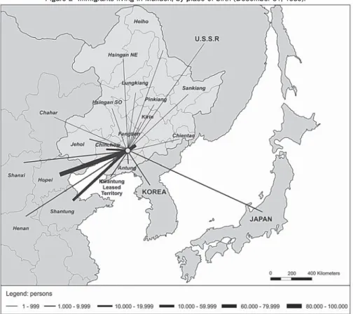
International migration and rural-urban movements increased the population of Manchurian cities more than any other demographic variable (see Figure 2). The population growth of cities all over Manchuria was stimulated by the expansion of transportation facilities and economic transformations in process, and it was particularly important during the period of Manchukuo. Not only did the old cities
grow but new cities sprang up, especially at the railway junctions. American demographer Irene B. Taeuber10) stated ʻthe rapidity of urban growth in the brief history of the puppet state of Manchoukuo has few parallels in the history of either West or Eastʼ (Taeuber 1945:265).
However, the degree of urbanization of Manchukuo was still very low when compared with other countries. As reported by the 1940 census of Manchukuo, there were in Manchukuo 121 population centres with more than 20,000 inhabitants. Among them, were 3 cities with more than half a million inhabitants, 12 cities with 100,000- 500,000 inhabitants, and 14 cities with 50,000-100,000 inhabitants. Compared to coeval
Japan, the number of medium size cities with between 50,000-100,000 inhabitants was remarkably small. On the contrary, the number of towns with around 20,000 and
Figure 2 Immigrants living in Mukden, by place of birth (December 31, 1935).
Source: Manchukuo, Kokumuin, Sômuchô, Tôkeisho (1937) Dai ichiji rinji jinkô chôsa hôkokusho. Toyû hen, dai sankan, Hôten shi, Tôkeisho hen. Table 7.
Note: Immigrants living in the SMR municipal area are not included.
30,000 inhabitants with agricultural functions was larger than expected in
Manchukuo (Numata, 1942:222; Asai, 1941).
Making use of Manchukuoʼs latest official population statistics taken at the end of 1941 (one year after the census of Manchukuo), there were 15 large cities (100,000 or
more inhabitants) in Manchukuo. These cities concentrated 4.6 million persons, only 10% of the total population of the new state, which still remained predominantly
agricultural, although these large cities were representative of the politics, economics and cultural life of the new state (Yamaguchi, 1944:101; Taeuber, 1945:265; Taeuber, 1974). Mukden (Fengtien, or Hōten, present-day Shenyang) was the largest with 1.2
million inhabitants; followed by Harbin and Hsinking (Changchun, or Shinkyō), the capital of Manchukuo (with more than 500,000 inhabitants); Antung, Fushun, Kirin and Anshan (more than 200,000); Mutankiang, Yingkou, Fushin, Penhsihu, Chinhsien, Tsitsihar, Chiamussu, Liaoyang (more than 100,000).
Eleven of the large cities were located in the more developed and populated South Manchuria, extending southward from the special municipality of Hsinking i.e., the former Japanese sphere of influence. Three major cities (Harbin, Mutankiang and Tsitsihar) were connected via the former Russian railways network (CER) in North Manchuria; and one large city (Chiamussu) was situated in the northeast of Manchuria. The proliferation of the large Manchurian cities was spectacular. In four years (1938-1941), the number of large cities rose from 8 to 15, revealing the pace of development in Manchukuo. Its population increased from 2.7 million to 4.6 million, an increase of 70% over this period. That is a much greater rate of increase than the total of Manchurian cities (312 cities) for the same period, which was an increase of the 47.8%. Reflecting on the non-demographic factors that explain this high urbanization level, Taeuber states that ʻthe phenomenal growth of cities in Kwantung and Manchukuo is the most reliable measure available of the economic transformations in process during the decade of agricultural and industrial expansion and military preparedness that preceded Japanʼs war for continental hegemonyʼ (Taeuber, 1945:265). Contemporary human geographer Heishirô Yamaguchi justifies these increases by the functional importance acquired by large cities in wartime
compared to mid-sized cities and rural areas. However, as Yamaguchi has indicated, such statistical growth was also due to the enlargement of the city area in almost all the major cities in Manchuria (Yamaguchi, 1944:101) under the guidelines of the municipal construction bureaus.
4.1 Gender and age imbalance in the cities
Among the most important demographic characteristics of the Manchurian- Manchukuo large cities growth process is the great imbalance in the numerical relationship of the sexes and age groups. These distribution differences were, in fact, common to other colonial cities in the world, and were not so visible in Manchurian rural areas.
These urban imbalances were due to the impact of massive international and domestic immigration and features of geographic location such as the existence of collieries or iron and steel works, and military facilities. More males than females entered Manchuria, especially those labour migrants coming from China proper who showed the highest sex ratios11) in the urban areas. They used to leave their families in North China and move alone to the Manchurian cities (individual migration) for economic reasons. However, despite their higher economic status, also Japanese immigrants frequently immigrate alone due to the ʻdespairing difficulties in finding adequate housingʼ (Numata, 1942:227). Based on her pioneer demographic analysis of the 1940 census of Manchukuo, Taeuber confirms that the range among the fifteen cities of 100.000 or more inhabitants went from 128 in Liaoyang and 138 in Antung, both old cities, to 200 in Mutankiang and 259 in Penshihu, both war-boom cities. The mean ratio was that of 166 for Hsinking (Taeuber, 1945:266).
Similarly, Taeuber finds that the age structure of the large Manchurian cities was distorted due to the rapid inflow of migrants. ʻThe numerical relations of the sexes in childhood were those normal for a sedentary population, but beginning with early adolescence, the male population was increased disproportionally by migration until in the central working ages of 15 to 50ʼ (Taeuber, 1945:267), producing important effects on marriage pattern and family structure.
4.2 Differences in ethnic composition
Considering once more the latest statistics of December 31, 1941, it is possible to observe the ethnic composition of these large cities, which varied as a result of each cityʼs migration history. On the average, the 15 largest cities in Manchukuo were inhabited by 81.5% Han Chinese and Manchus12), 0.2 % Mongols, 14.2% Japanese, 3.3% Koreans and 0.7% with no nationality (Czarist Russians). Unlike other
nationalities, the Japanese were better represented in cities than in the national total, with 14.2% versus 2.4%, due to their political, economic and cultural occupations and their role as ʻleaders of Manchukuoʼ (Yamaguchi, 1944:106). This was also the case of Czarist Russians, who were mainly concentrated in Harbin although their absolute number was small. The Mongols were almost non-existent in large Manchurian cities.
Koreans maintained exactly the same proportion as in the rest of the country, and the Chinese were distributed throughout the state although, due to the strong Japanese presence in the cities, they were 10% less than the national average. We highlight the increase of the proportion of Japanese urban residents compared with other nationalities, especially since 1937 due to immigration from Japan. Thus, we find
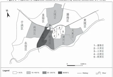
Source: Manchukuo, Hôten shi kôshokanbô chôsa-ka (1943) Hôten tôkei nenpô, Kôtoku jûʼnen, Hôten shi kôsho hen. Table 1.
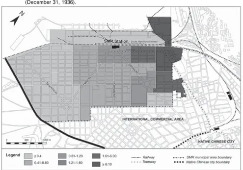
Figure 3 Proportion of Japanese residents in Mukden, by district (December 31, 1942).
large proportions of Japanese in Mutankiang (28%), Hsinking (25%), Anshan (23%), Mukden (16%), and Fushun (15%), as well as ratios of slightly above 10% in Chinhsien, Chiamussu, Tsitsihar and Kirin. Although Japanese presence in large cities was important, they remained very residentially segregated as compared with other ethnic groups, even during the Manchukuo period. Taking the example of Mukden in 1942 (see Figure 3), they still preferred to live in the ex-SMR area and its surroundings than in the walled city.
5 Occupied Mukden: a city on the move
Along with other major Manchurian cities, Mukden growth was closely linked to the general economic development produced under Japanese imperialism in Manchuria. A city steeped in history, Mukden was transformed politically, physically and socially very rapidly from 1906, when the Japanese replaced Czarist Russians and started urbanizing around the SMR railway station of Mukden, in a concession territory granted by imperial China and transferred from Russia after the Russo- Japanese War. Over time, this railway land became an entirely new city. It was situated near the native city of Mukden, to which the Chinese government had just added (1905) an ʻInternational commercial areaʼ (Shang-fu-ti), as a border district between the Chinese city and the Japanese settlement. Thus, until Manchukuo and for three decades, Mukden fell under a condominium of the governments of China and Japan.
Mukden stood as the most populated city of Manchuria-Manchukuo. It was the hub of Manchuriaʼs roadways and rail lines and the largest industrial and commercial centre. It was also the site of the Arsenal, ʻone of the largest, if not actually the largest, in the world. When working full time, it employed over seven thousand workmenʼ (Woodhead, 1932:58) and the future ʻbasis for the development of the machine industry of Manchuriaʼ (Grajdanzev, 1945:335). So, during the Manchukuo period, the Japanese built up the city industrially and enlarged it, attracting many migrants, mostly from Manchurian rural areas, North China and Japan. It became
the major destination of domestic and international migrant flows in Manchuria, including Japanese flows. Among them, the greatest proportion were low-skilled Chinese labourers, so that in 1935, more than half of the Chinese residents between 29 and 49 years of age had been born south of the Great Wall (see Figure 2).
As a result, the population multiplied tenfold between 1910 and 1942, reaching 1,577,176 inhabitants as of December 31, 1942. It was a predominantly a Chinese city,
with 82.4 % Han Chinese-Manchu residents (9:1 ratio). The Japanese made up 13.4%
of the Mukden residents, the Koreans 4.2% and the ʻforeignersʼ (mainly Czarist Russians) just 0.1%. The massive influx of migrants had affected sex and age structures, turning it into a predominantly masculine and young metropolis, presenting a high sex ratio of 172 and a low dependent-productive ratio, as 46.6% of the entire population of Mukden was between the ages of 16 and 35, according to the 1940 census of Manchukuo.
5.1 Uneven ethnic spatial distribution
Diverse population and flows could have led to a space of multicultural coexistence, as was the ideology of ʻracial harmonyʼ ―Minzoku kyowa― of the Manchukuo state (McCormack, 1991). However, like other European-power colonial cities, Mukden was not only a space of urban change, but also a place of barriers and ethnic separation.
Japanese colonialism helped create ethnically heterogeneous societies while separating the different ethnic groups, organizing the space through the practice of zoning and control of the native culture. In Manchuria, however, residential segregation was not only determined by ethnicity (principal segregation factor), but also by social class (Mizuuchi, 1985).
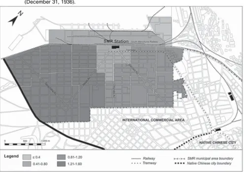
Focusing on the Japanese railway settlement, we present as a corollary to this research maps showing the different residential patterns of the main ethnic groups in Mukden according to their location quotient values (LQ) in the year 1936. As we have already noted (see Figure 3), the Japanese lived mostly in the SMR municipal area of Mukden. These three maps show how they were almost evenly distributed throughout this space, but with an important concentration in certain districts, especially those containing the SMR Co employeesʼ dormitories and houses (see
Figure 4 Representation of LQ values for Japanese residents in the SMR municipal area at Mukden (December 31, 1936).
Figure 5 Representation of LQ values for Chinese residents in the SMR municipal area at Mukden (December 31, 1936).
Source: Kwantung, Kantô-chô (1937) Dai sanjûʼichi tôkei-sho, Kantô-chô hen. Table 9.
Source: Kwantung, Kantô-chô (1937) Dai sanjûʼichi tôkei-sho, Kantô-chô hen. Table 9.
Figure 4). In contrast, other ethnic groups were fewer in number and highly concentrated in certain districts of the Japanese railway settlement (see Figures 5 and 6), but more evenly distributed in the rest of city. These specific ethnic settlement patterns were common in other urban areas along the SMR Zone and remained uneven after the creation of Manchukuo.
Acknowledgements: The author wishes to thank Tanausú Pérez García of The University of Las Palmas de Gran Canaria for his cartographic assistance, and Virginia Navascués Howard for correcting the final English version.
Notes
1) According to P. Duus, ʻconcession imperialismʼ was halfway between the ʻimperialism of free tradeʼ and direct colonial rule (Duus, 1995:11).
2) The CER was renamed North Manchuria Railway after March 23 of 1935, when it was sold to Manchukuo, which entrusted the management of the line and its affiliated enterprises to the SMR Company.
3) The latter was actually ruled by Czarist Russia until 1924, when it came under joint and equal control of the governments of China and Soviet Russia.
Figure 6 Representation of LQ values for Korean residents in the SMR municipal area at Mukden (December 31, 1936).
Source: Kwantung, Kantô-chô (1937) Dai sanjûʼichi tôkei-sho, Kantô-chô hen. Table 9.
4) The formal abolition of extraterritoriality in Manchukuo took place on December 1, 1937.
5) We refer here to the CER (1903), SMR (1907) and the British-financed railway from Peking through Shanhaikuan to Mukden (1907).
6) Quantitative data are practically coterminous with Japanese control, and as such, are biased in collection, processing, presentation and interpretation. Sources of the data are the records of Japan.
7) In 1933, the new State granted the right to own farm land to the Japanese and thus opened up vast areas in Manchuria for Japanese immigration (SMR Co., 1936:129).
8) It should be noted, however, that from 1933, other Korean entry ports were used as an alternative to those of Kwantung (mainly Dairen, or Dalian). Therefore, the figures do not represent all the entries.
9) The Youth Volunteer Corps for the Colonization of Manchukuo was organized in 1938 to promote the colonization of the Asiatic continent. ʻThe immediate objective of this organization was to train Japanese youths between the ages of 16 and 19 in farming, thus moulding their character as leaders of the colonizationʼ (Bureau of Northern Affairs, 1941:397).
10) Demographer Irene B. Taeuber was a pioneer in the study of the population of Eastern Asia during the 1930s and 1940s. She co-edited the journal Population Index, beginning in 1936, and authored the classic The Population of Japan (1958), a demographic survey of Japan that has been mentioned extensively in this investigation.
11) Sex ratio is defined as the number of males per 100 females.
12) ʻMankanzokuʼ. The term refers to Manchus and Han Chinese combined. In this case, it is not possible to know the percentage of each ethnic group but making use of the 1940 census of Manchukuo, we know that Manchus were a very small proportion of the inhabitants of the cities. For instance, in Mukden, the ancestral capital of Manchu, there were only 8.7%, and in Hsinking, the new capital of Manchukuo, 1.5%.
References
Adachi, K. (1925) Manchuria: A Survey, R. M. McBride & Co.
Asano Tamanoi, M. (2005) Crossed Histories. Manchuria in the Age of Empire, Univ. of Hawaii Pr.
Avila Tàpies, R. (1998) “La emigración histórica japonesa a Manchuria: estado de la cuestión y documentación,” Estudios Geográficos, Vol.59-233, pp.739-753.
Avila Tàpies, R. (2012) “Territorialidad y etnicidad en Manchuria: El ejemplo de la ciudad de Mukden (Shenyang) bajo la ocupación japonesa,” Biblio 3W. Revista Bibliográfica de Geografía y Ciencias Sociales, Vol.17-959. URL:[http://www.ub.es/geocrit/b3w-959.htm]
Bureau of Northern Affairs, Department of Overseas Affairs (1941) “Third report on the colonization of the continent,” Tokyo Gazette, April, pp.396-401.
Chou, S.H. (1971) “Railway development and economic growth in Manchuria,” The China Quaterly, Vol.45, pp.57-84.
Duus, P. (1995) The Abacus and the Sword. The Japanese Penetration of Korea, 1895-1910, Univ. California Pr.
Gottschang, T.R. (1987) “Economic change, disasters, and migration: The historical case of Manchuria,” Economic Development and Cultural Change, Vol.35, pp.461-490.
Grajdanzev, A.J. (1945) “Manchuria: an industrial survey,” Pacific Affairs, Vol.19-4, pp.321- 339.
Grajdanzev, A.J. (1946) “Manchuria as a region of colonization,” Pacific Affairs, Vol.19-1, pp.5-19.
Ho, P.T. (1967) Studies on the Population of China, 1368-1953, Harvard Univ. Pr.
Ladejinsky, W.I. (1941) “Manchurian agriculture under Japanese control,” Foreign Agriculture, Vol.5-8, pp.309-340.
Lattimore, O. (1932) “Chinese Colonization in Manchuria,” The Geographical Review, Vol.22- 2, pp.177-195.
Lattimore, O. (1934) The Mongols of Manchuria, John Day Ed.
Lee, H. K. (1932) “Korean Migrants in Manchuria,” The Geographical Review, Vol.22-2, pp.196-204.
Matsusaka, Y.T. (2001) The Making of Japanese Manchuria, 1904-1932, Harvard Univ. Pr.
McCormack, G. (1991) “Manchukuo: constructing the past,” East Asian History, Vol.2, pp.105-124.
Pan,C.L. and Taeuber, I.B. (1952) “The expansion of the Chinese: north and west,”
Population Index, Vol.18-2, pp.85-108.
Sánchez, J.E. (1981) La Geografía y el Espacio Social del Poder, Libros de la Frontera.
S.M.R.Co. (1936) Fifth Report on Progress in Manchuria to 1936, S.M.R.Co.
Taeuber, I.B. (1945) “Manchuria as a demographic frontier,” Population Index, Vol.11-4, pp.260-274.
Taeuber, I.B. (1950) “Korea and the Koreans in the Northeast Asian region,” Population Index, Vol.16-4, pp.278-297.
Taeuber, I.B. (1958) The Population of Japan, Princeton Univ. Pr.(毎日新聞社人口問題調査会
(訳)編 (1964)『日本の人口』毎日新聞社人口問題調査会)
Taeuber, I.B. (1974) “Migrants and cities in Japan, Taiwan, and Northeast China,” in Elvin, M. and Skinner, W.G. eds. The Chinese City between Two Worlds, Stanford Univ. Pr., pp.359-384.
Wang, C.C. (1933) “The Sale of the Chinese Eastern Railway,” Foreign Affairs, Vol.12-1,
pp.57-70.
Woodhead, H.G.W. (1932) A Visit to Manchukuo, The Mercury Pr.
Yang, D. (2010) Technology of Empire. Telecommunications and Japanese Expansion in Asia, Harvard Univ. Pr.
Young, W.C. (1931) Japanese Jurisdiction in the South Manchuria Railway Areas, The Johns Hopkins Pr.
浅井得一(1941)『滿洲國都市人口の増減に就いて―人口配置計畫研究(其の三)』(康徳 8 年 12 月)総務廰企画處綜合立地計畫室。
アビラ・タピエス,ロサリア(2002)「近代における旧満州への日本人の移住およびその定着パ ターンについて」『甲南大学紀要文学編歴史文化特集』129, pp. 34-59。
蘭信三(1994)『「滿洲移民」の歴史社会学』行路社。
沼田征矢雄(1942)「新京及び奉天の人口構成に就いて―國勢調査の結果より見たる―」『人口 問題』4-2, pp.223-227。
満州開拓史復刊委員会編(1980)『満州開拓史』全国拓友協議会。
水内俊雄(1985)「植民地都市大連の都市形成―1899 〜 1945―」『人文地理』37-5, pp.50-67。
南滿洲鐵道株式會社總裁室地方部残務整理委員會編(1977,初版 1939)『滿鐵附属地經營沿革全
史』上巻, 南満州鉄道株式会社。
山口平四郎(1944)「滿洲都市人口動態の地域性」『満鉄調査月報』24-1, pp.73-124。
依田憙家(1984,初版 1976)「満州における朝鮮人移民」満州移民史研究会編『日本帝国主義下 の満州移民』龍渓書舎, pp.491-603。