Southeast As£an Stud£es, Vol. 11, No.3, December 1973
A Subdivision of the Chao Phraya Delta in Thailand
Based on Hydrographical Conditions
Water Conditions in Deltaic Lowland Rice Fields
(I)
byYoshihiro KAIDA
*
Abstract
Based on hydrographical conditions for rice cultivation, the lowland rice area in the deltaic region of the Chao Phraya river basin in Thailand was subdivided into five zones. The zones were comprised of (1) Main Area of the Old Delta, (2) Chains of Depressions, (3) Retarding Basin of the Delta, (4) Poldered Flat Delta, and (5) Knotty River Area of the Coastal Zone (Fig. 8). Hydrographical conditions were described for each zone. Hydrographical elements taken for the subdivision of the region were; method of rice cultivation, eg. transplanted or broadcast, as an indicator of general water condition in the fields (Fig. 1), date of transplanting as an indicator of the water conditions at the early stage of rice growing (Fig. 2), period of inundation (Fig. 3), depth of the maximum inundation (Fig. 4), date of the maximum inundation (Fig. 5), rate of increase of the water table (Fig. 6), and drainability (Fig. 7).
Introduction
This paper aims at examining various phases of water conditions in the cultivation of main season rice in the deltaic region of the Chao Phraya river basin, to understand more dearly the "rice culture" in the region. Tn the previous paper by the writer, he made a statistical analysis on the effects of environmental factors on paddy rice yields in which the effect of water conditions on the yield was made dear.I ) Rut the recognition of the areal extension of each factor was minimal. The present paper will supplement the previous one in regard to the regional extension of environmental factors, especially of water conditions, as related to rice cultivation.
Sources of Data
The original data used in this analysis are in the "crop outlook report" and "daily records of river and canal discharge and water gauge reading" of the Greater Chao Phraya Project for the water year 1968 which was compiled by the Royal Irrigation Department. Detailed description of the methods of processing the original data from the above sources
is presented in the previous paper. Lack of information in these data was partly supplemented by the author's own observations which were taken during April 1969 to January 1970.
Results and Discussions
Results of the analysis on various phases of rice growth and water conditions are demon-strated in the following maps using the same scale throughout Fig. 1 through Fig. 8. Dis-cussion will be focused on the regional distribution of water conditions as related to rice cultivation.
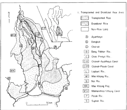
1. Transplanted and Broadcast Rice
Area planted to transplanted rice and broadcast rice are divided rather boldly as shown in Fig. 1. In this map the "transplanted rice area" stands for the area where predominantly transplanted rice is grown, and the "broadcast rice area" is the area where broadcast rice is dominant. Therefore, there might be some patches of appreciable acreage planted to transplanted rice in the broadcast rice area, and vice versa.
The transplanted rice area is restricted to (n marginal zones of the delta mostly com-posed of the Fan-Terrace Complex,2) (2) river levees of the Old Delta2), and (3) a slightly elevated area toward the coastal zone, which is called the Coastal High2). The West Bank Tract northwest of Bangkok is an exceptional area since the early season rice is grown quite extensively to avoid damages from high flood in the later part of the rainy season. The broadcast rice area is in (1) the Trough3
>,
(2) backswamps in the Old Delta, and (3) in the northern half of the Young Delta2).2. Date of Transplanting
The transplanting date is a good indicator of the availability and stableness of water in the early stages of the growing season. Transplanting of the main season rice starts in early July for the commanding area of the Suphan and the Chainat-Pasak canals in the Old Delta. In other parts of the Old Delta they finish transplanting by the end of July. Transplanting commences in August in patches of transplanted rice fields in the "broadcast area". Those patches of fields are usually situated on raised land in lowlying areas, where they have no facilities for obtaining water other than by rainfall until the water table in the whole area is raised substantially. The latest transplanting in the Delta takes place toward the end of August in the lowermost reaches of the Chao Phraya on the right bank, the Bang Yang area. The early season rice in the West Bank Tract is usually planted between May 15 and June 10 and harvested before the period of deep flooding starts.
Note that the transplanting date is largely controlled by the operational irrigation practices of the Royal Irrigation Department, which is based on a rotational supply of water by the main canal system. For example, the Chainat-Pasak canal receives water early in the season since it has to sent water to a very elongated area from Chainat down to the coastal
Y. KAIDA: Subdivision of the Chao Phraya Delta in Thailand Based on Hydrographical Conditions zone on the left bank. Thus, certain zones in the commanding area are the first to start transplanting in the Delta.
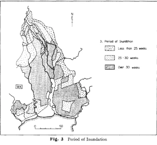
3. Period of Inundation
As shown in Fig. 3, the whole delta is divided into three zones in terms of the period of inundation of rice fields. Ponded water depth over 5 ern is considered as "inundated" in this case. The levees and a large part of the marginal area of the Delta receive ponded water for less than 25 weeks which approximately coincides with the growing season for transplanted rice. Most parts of the broadcast area are inundated for a period of 30 weeks, which is roughly equals the entire growing period for broadcast nce.
4. Depth of Maximum Inundation
As shown in Fig. 4, the region was subdivided into five zones based on the maximum depth of inundation for the season. The shallowest depth, less than 20 em, occuns in the Fan-Terrace Complex, at levees at the upper reaches of such main distributaries as the Suphan and the Noi, and in the lowermost reaches of the Chao Phraya and the Suphan in the West Bank and the Bang Yang area. The latter area, however, is rather exceptional as they usually harvest the early season rice before the beginning of the highest flood. The depressional area in the center of the Delta receives the highest inundation, over 60 em, where only broadcast rice can be grown. The deepest water depth, over 100 em, occurrs for a prolonged period in (1) the Trough, (2) chains of depressional zones between the Suphan and the N oi, (3) northernmost corner of the Young Delta, and (4) the South Pasak Project area in the Young Delta northeast of Bangkok.
These deep water areas can be understood as "dumping places" for water from the surrounding levees and Fan-Terrace Complex, when a map indicating the date of maximum inundation (Fig. 5) or that of the rate of increase of the water table (Fig. 6) is superimposed on Fig. 4. A stable and shallower water depth in the elevated area can only be sustained by excessively high floods in these lowlying areas.
Water depth in the coastal zones on both banks IS rather stable, and the maximum depth does not exceed 50-60 em.
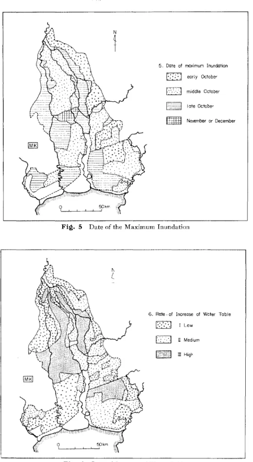
5. Date of Maximum Inundation
The maximum inundation in the Trough and the huge depressional area at the northern-most edge of the Young Delta takes place from late October to November, sometimes even towards December, since these large areas receive water drained from the surrounding Fan-Terrace Complex and the depressional zones in the Old Delta. However, the maximum depth attained by the chains of depressions in the Old Delta occurrs in the middle of October since its topography is on a smaller scale, of narrower width and relatively sharp relief. This relatively early submergence takes place because the backswamps are flushed with water from the levees shortly after the heaviest rainfall from late September to early October.
The flood comes, of course, so slowly toward coastal zones that the Coastal High attains its maximum inundation in late October.
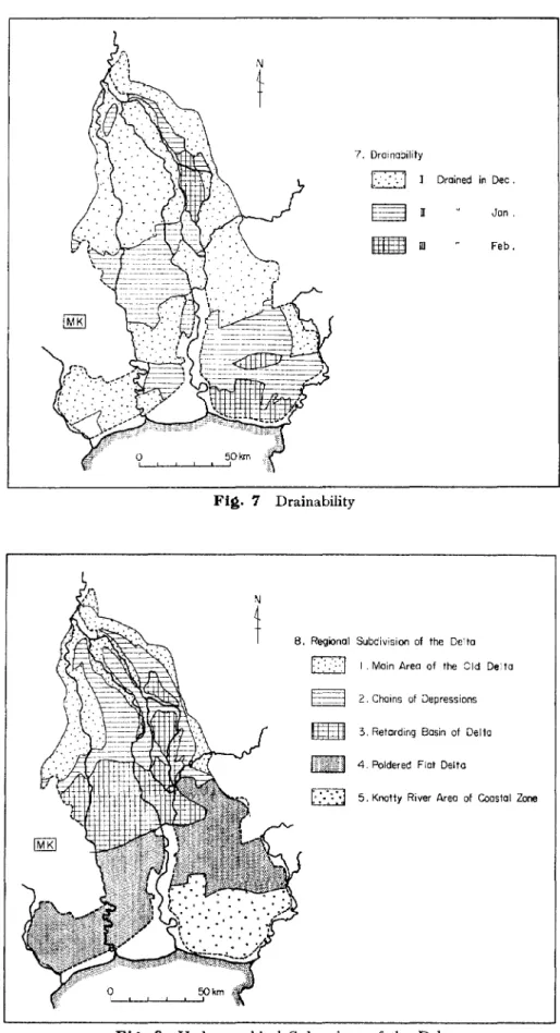
6. Rate of Increase of the Water Table
The region was subdivided into three classes based on the rate of increase of the water table in the paddy fields as shown in Fig. 6. Class I includes (1) most parts of the Fan-Terrace Complex, (2) the northern part of the big levees, and (3) the lower reaches of the Chao Phraya on the right bank, and (4) the lower reaches of the Bang Pakong on the right bank. Class I indicates that the water table comes up very slowly so that they can maintain a shallow water depth with very small fluctuations for at least 20 weeks. This area cor-responds to the best rice area in terms of yield as was made clear in the previous paper. Class III which includes (1)the Trough, (2)chains of depressions in the Old Delta, (3)the northern-most edge of the Young Delta, that is, Phakhai, Phophraya, and the northern part of the West Bank Tract, and (4) the South Pasak project, usually suffers from rapid increases of the water table, and this, in an area where other than broadcast rice of tall varieties can not be grown. The transplanted rice area is restlicted to the nrea defined as Class I or to small parts of Class II.
7. Drainability
The drainability of paddy fields is categorized into three simple classes as mapped out III Fig. 7. Class I can drain ponded water completely by the end of December, Class II by the end of January, and Class III after the end of February. The main part of the Old Delta, including, of course, the Fan-Terrace Complex, has good drainability, and is categorized as Class 1. A general slope of ca. 1/5,000 and the relatively sharp relief characteristic to the Old Delta allow this area's easy drainage. In most parts of the Young Delta, ponded water remains on the fields up until the end of January. Drainability is poor in the extreme coastal zones on the left bank because of the presence of a coastal embankment built to protect against the intrusion of sea water. The Trough is the most difficult to drain completely. In particular areas of this zone standing water remains even up until the middle of March. 8. Regional Subdivision of the Delta based on Hydrographic Conditions
The writer tried to integrate the seven maps, Fig. 1 through Fig. 7, into a single map indicating the regional subdivisions of the Delta based on hydrographic conditions in areas of lowland rice cultivation. A rough idea of the subdivision into five zones is shown in Fig. 8. Borderlines of zones are tentative and, as can easily be guessed, they are not accurate since all of the data used in this analysis was averaged in terms of "zones"!) of the irrigation project.
Zone 1. Main Area of the Old Delta
Zone 1 is composed of the Fan-Terrace Complex, the main area of the Old Delta marked by gentle slopes and a relatIvely flat terrain, and the narrow strips of natural river levees along
Y. KAIDA: Subdivision of the Chao Phraya Delta in Thailand Based on Hydrographical Conditions the major distributaries. The depth of ponded water on the fields can be maintained at a relatively shallow level (not over 35 em) for at least 20 weeks. There is no threat of deep prolonged inundation. This is because irrigation networks of the main-lateral-tertiary canai-ditch system are implemented and operated fairly well. About 80% of the ditches are completely effective thanks to the appropriate topography for gravitational irrigation. Drainage is possible through natural and some man-made drainage canals into adjacent depressional zones.
Zone 1 is solely a "transplanted rice area" in the main season. The yield level is slightly over 3 tons/ha or close to it. The crop diversification program for off season cultivation is scheduled, but this scheme seems unsuccessful partly because the gravitational irrigation system does not work properly in the dry season due to a shortage of water. We must notice that this irrigation system is so designed that it meets the requirements for both supplementary irrigation for the main season rice and for flood dispersion during the flood season. Zone 2. Chains of Depressions
Zone 2 is composed of narrow strips of backswamps sandwitched between levees; rugged terrain of raised land and depressions between major distributaries; and marginal zones of the Trough. In short, Zone 2 is a "dumping place" for water from the surrounding Zone 1. Water conditions are very unstable, with a rapid increase of the water table shortly after heavy rainfall in the Old Delta. The average maximum water depth reaches 80-100 em, with 140-160 cm being the peak. Zone 2 is totally a broadcast area reflecting the unstable water conditions.
Notice that Zone 1 can maintain advantageous water conditions only at the expense of Zone 2. Drainage is rather difficult in the flood season. But the drainability in the late growing season is fairly good as all water can be drained into a huge depression, Zone 3. The drainage scheme now underway will greatly benefit this Zone, transforming some areas in it into a "transplanted area".
Zone 3. Retarding Basin of the Delta
Zone 3 is the whole area composed of the major part of the Trough and the huge depres-sion at the northwest corner of the Young Delta. Zone 3 can be said to be a huge retarding basin for the whole Delta with a reserving capacity of approximately more than 2X 101) m3 .4) The average maximum depth of water in the main season exceeds 100 em, with the peak depth reaching 200 cm. Cultivation of the tall varieties of broadcast rice as floating rice is the only feasible way of adapting to the '.vater condition.
Water conditions will not improve in the near future. A drastic plan incorporating a total flood protection srheme and a drainage project covering the entire Delta would be required if water conditions in Zone 3 are to be improved.
Zone 4. "Poldered" Flat Delta
Bank Tract, and Bang Yang areas. The terrain in this huge zone is characterized by flatness with very little relief. The average ground height is 1-2 m, and the general slope from north to south is ca. 1/20,000 to 1/25,000. The rate of increase of the water table in the high water season is rather low, though the water depth climbs to approximately 60 cm. General water conditions can be regulated to some extent by constructing large scale "polders" and drainage canals. This is proved by the fact that the whole area of Rangsit and the West Bank Tract has been developed by the poldering system with big man-made canals for a two-fold purpose, serving as a means of transportation and as a means of irrigation and drainage at the same time. The drainage and poldering scheme is underway in the Bang Yang area within the framework of the Maeklong Irrigation Project.
History tells us that once the government provides a big main canal and some secondary canals in a sparcely populated area in the Dt'lta, people themselves begin to settle along a canal, and then they gradually expand their territory into the hinterland of the canal by digging tertiary canal networks by their own efforts. They devise low lift pumps for irrigation using the reserved water in canals which is occasionally perennial in certain areas. The growth of early season rice vms initiated in this area, when certain conditions of water avail-ability and pumping facilities were provided. In the Bang Yang area, we see beautiful gardens of vegetables and fruit in poldered lands on a smaller scale, surrounded bv neatly maintained high dikes.
Zone 5. Knotty River Area of the Coastal Zone
Zone 5 roughly corresponds to the Coastal High. The zone is characterized by densely intricated water courses, both natural and artificial. Some canals have been constructed from long time ago (80--150 years) to supply water to the natural water course networks to supplement irrigation for the main season rice. Water in the Zone is late coming and late going, and generally more gentle compared to Zone. 4 The possibility of introducing new high yielding varieties of rice of short stature5) is relatively high even in the main season, thanks to the good "natural" water conditions in the major area of this Zone.
General Discussion
As was clearly observed in each map presented in the previous section, water conditions for rice cultivation is strongly governed by the geomorphological framework. The Greater Chao Phraya Project, which was aimed at supplementing irrigation water for a better and more stable cultivation of main season rice, made a great contribution towards increasing the total production of rice as well as the paddy yield per unit area, jn the following ways: (1) Extended the irrigable area into the marginal areas of the Delta by diverting water from the Chainat headworks.
Y. KAIDA: Subdivision of thc Chao Phraya Delta in Thailand Based on Hydrographical Conditions in Zone 1, Zone 4 and Zone S, thanks to better water supplies in the early growing season. Better cultivation can be practised only in a transplanted rice field. The percentage of transplanted area to total area in the Delta increased gradually year after year since the completion of the project, ego 22% before 1957, 35% in 1964, 37% in 1965, 40% in 1966, 42°!c> in 1967, and 55% in 1970.
(3) Provided certain areas, especially in Zone 1, with the possibility of implementing land consolidation projects in the near future, owing to the better control of floods.
(4) Made possible the cultivation of early season rice in the West Bank Tract in Zone 4 due to a better supply of water in the early seasons of the year.
Nevertheless, we must recognize that certain parts of the Delta are worse off because of this project. One example is the somewhat deteriolated water condition in Zone 2. The canal network is designed so that water comes from a main and a lateral canal on the levee down to the depression. This means the levee areas (Zone 1) benefit in two ways. They can get irrigation water with higher priority when necessary, and they can easily drain excessive water as required, into the depression through irrigation and drainage systems. Zone 2 thus suffers from a water shortage in the early season and from severer floods in the high water season. vVe must also be aware that with the present irrigation and drainage system improvement of water conditions in the main area (Zone 1) can only be accomplished at the expense of Zone 2 and Zone 3.
Drainage of excess water from Zone 2 and Zone 3 is the most important and the most urgent problem that must be solved in the Delta. Further improvement in the irrigation, drainage and flood control schemes of Zone 4 and Zone 5 will have to be considered in con-junction with a master plan for the drainage of Zone 2 and Zone 3.
Acknovvledge~ent
Field survey carried out in 1969/70 was made under the auspieces of the National Research Council of Thailand. The writer is grateful to Mr. Charin Atthayodhin, Phaitoon Palayasoot, and Mr. Chuchawal Sawatdirurk of the Royal Irrigation Department of Thailand for their kind assistance in supplying research facilities and valuahle information.
References
1) Kaida, Y. 1971. "An analysis of the effect of environmental factors on paddy rice yields, a case study of the northern region of the Greater Chao Phraya Project," Sout/teast Asian Studies (Ton an Asia Kenkyu), Vol. 9, No.2, pp. 254-282. Kyoto: SEAS
2) Takaya, Y. 1971. "Physiography of rice land in the Chao Phraya Basin of Thailand," Southeast Asian
Studies (Tonan Asia Kenkyu), Vol. 9, No.3, pp. 375-397. Kyoto: SEAS
3) Takaya, Y. 1969. Topographical analysis of the southern basin of the Central Plain, Thailand.
South-east Asian Studies (Tonan Asia Kenkyu), Vol. 7, No.3, pp. 293-300. Kyoto: SEAS
4) NEDECO/RID 1970. Northern Chao Phraya Study, part IiI Drainage and flood control. p. 136.
The Hague: NEDECO
5) Fukui, H. 1971. "Environmental determinants affecting the potential dissemination of high yielding varieties of rice, a case study of the Chao Phraya River basin," Southeast Asian Studies (Tonan Asia Kenkyu), Vol. 9, No.3, pp. 348-374. Kyoto: SEAS
I. Transplanted and Broadcast Rice Area
0
Transplanted Rice Broadcast Riced
Non-Rice Land @ Ayutthaya @ Bangkok © Chainatrn
Bang Pakhon Riv.W
Chao Phraya Riv.IC-AI Chainat -Ayutthaya CanaI
Ic-pi Chainal-Pasak Canal
[JJ Lopburi Riv.
[1D Moe Khlong Riv.
[]] No; Riv.
~ Mae Khlong Proj.
IMUI Makhamthao-Uthong Canal
[£] Pasak Riv.
IT] Suphan Riv.
Fig. 1 Area for Transplanted and Broadcast Rice
2. Date of Transplanting ~ ~ ~ Li.:.:...:J
[[]]
~mJID
Fig. 2 Date of Transplanting
July 1-15
July 15-31
August 1-15 August
16-May-June (Early season rice)
Y. KAIDA: Subdivision of the Chao Phraya Delta in Thailand Based on Hydrographical Conditions
3. Period of Inundation
4. Maximum Depth of Inundation
Utuu
Over 100em~
~
o
Fil;l. 3 Period of Inundation
D"'.
oC ' , ", ° ' 0
~ ~ [[]]
Less than 25 weeks
25 - 30 weeks Over 30 weeks Less than 20 em 20-40em 40 60 em 60-IOOem
5. Date of maximum Inundation ~ November or December r:-:::'l ~
D
~ early October middle October Iate OctaberFig. 5 Date of the Maximum Inundation
6. Rate - of Increase of Water Table
D·'
0" 0. o· " •D···
.':.".' Low IT Medium mHighY. KAIDA: Suhdivision of the Chao Phraya Delta in Thailand Based on Hydrographical Conditions 'r. Drainability
D ··
::';'.' ~===1 nmf:W
ill Drained in Dec. Jon, Feb. Fig. 7 DrainabilityRegional Subdivision of the Delta
r: ,:
.:,::.-1 'Main Area of the Old Del tot=--l
2, Chains of Depressionsmtm
3, Retording Basin of Delta4, Poldered Flat Delta