Study of Condominium Community: Nimmanhaemin District, Chiang Mai Thailand
著者 Kitika Chiranthanin, Katsuhiko Suzuki journal or
publication title
International Review for Spatial Planning and Sustainable Development
volume 4
number 1
page range 106‑122
year 2016‑01‑15
URL http://hdl.handle.net/2297/45050
doi: 10.14246/irspsd.4.1_106
106
Copyright@SPSD Press from 2010, SPSD Press, Kanazawa
Integrated Neighbourhood Network on A Case Study of Condominium Community: Nimmanhaemin
District, Chiang Mai Thailand
Kitika Chiranthanin
1*and Katsuhiko Suzuki
11 Department of Architecture, Kyoto Intitute of Technology
* Corresponding Author, Email: [email protected] Received 20 May, 2015; Accepted 10 September, 2015 Key words: Neighbourhood, Urban Management, Apartment
Abstract: Chiang Mai is the second biggest city in Thailand. With its own history, this city has been represented as a culture city but many economic growths have been increasing at the same time. Many areas in the city are turning toward economic purposes, especially Nimmanhaemin District, which is currently well known as a business district for dining and entertainment spots where it was originally a planned area for single house real estate and had followed grid system planning following modern thought since 1980s. The strong character of this district is in its street network which is related to the grid system and provides for communities on “Soi” (Thai, meaning alleys that connect to the main street). With rapidly economic development in the last 15 years, area uses on the Nimmanhaemin street network have been turning toward business purposes and have grown without direction or limits. The most invested in are residential and commercial uses. There can be found numbers of new apartments which were built into old residential areas. In addition, researchers have found conflicts and controversies between old residents and new communities which are permanently related to urban management such as traffic circulation, zoning, image of the city and community design. Because previous government strategies were lacking local input, analysis of existing communities’ relations is required. This research hypothesis is to posit sustainable communities which move forward with a
“Community Drive” where cultural and creative activities create a balance between social relations (Existing residents and present business grouping) and business aims. Then, this research aims to integrate “Neighbourhood” into apartments which lack social interaction and public mind as a part of community. This research methodology identifies the relationship between existing residents and present business groups which refer to concerned theories; “The Production of Space” theory by Henri Lefebvre and
“Neighbourhood” by Nicholas Patricios, which defines the “Neighbourhood”
concept as a retrospective of physical design and social interaction. Analysis was conducted based on community participation and questionnaire data. The implications of this research are applications and strategies toward integrating a “Neighbourhood Network” on a condominium floor plan for a case study of a condominium community.
1. BACKGROUND
1.1 City planning
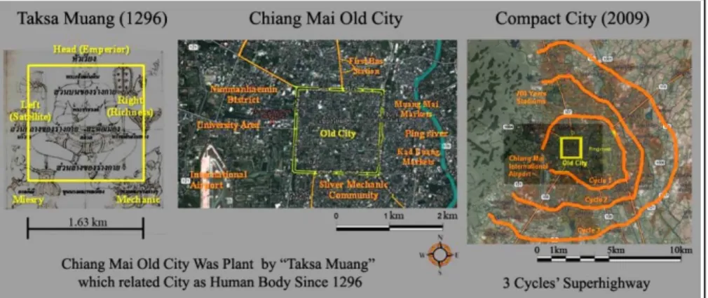
Chiang Mai City was established as Lanna Kingdom and its city planning has existed since 1296. With “Taksa Muang” being the ideal system, city planning was managed by following this ideal. Chiang Mai Old City originally referred to a human body, with the head at the north of the city as a main entrance for the emperor; the foot in the south, intended to be a negative side, for example, for graves and lower-class people; the right hand side is on the east of the city which connects to Ping river and was for living and commercial areas; while the left hand side is the west of the city which connects to Suthep Mountain for religious and educational purposes. The centre of the city is set in the middle as a navel of the human body. In Figure 1, Chiang Mai’s three street cycles or rings connect Chiang Mai to the expanding areas.
Figure 1. Chiang Mai city planning from Tuksa Muang (1296) to Compact City (2009)
Nimmanhaemin District was planned in the early 1980s. Nimmanhaemin District was owned by the Nimmanhaemin family. This land is a part of the first road cycle which connects with the superhighway, it is four lanes wide and 1.327km long. This street connects to other districts and also to the education node of the city. After this land was sold to individuals, Nimmanhaemin was originally planned for real estate and single house villages following modern thought. In Figure 2, those areas and streets can be seen as being physically bound by the grid system.
Figure 2. Nimmanhaemin Street Network (2012)
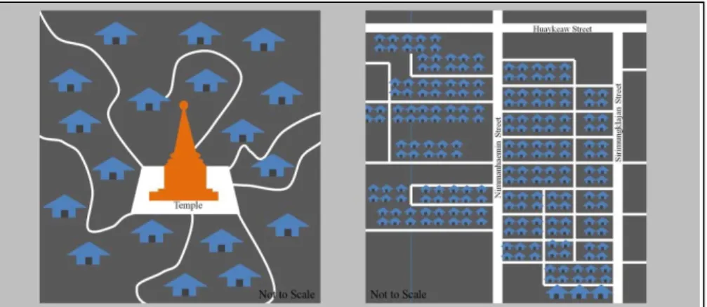
1.2 Community grouping
In Thailand, a community is originally grouped based on nearby areas residents around temples. A temple is reasonably the centre of the community where all residents are bounded with Buddhist activities and traditional events. Following modern development, the city was planned for infrastructure and public transportation which connects other districts with street networks. Until now, the temple is still maintained as the community centre for present activities such as elections, funeral ceremonies and Buddhist events. Nimmanhaemin District alone was planned as single house villages in the 1980s. Before that, there was an agriculture field owned by one family. In the northern part of Nimmanhaemin District, the Nimmanhaemin street network was created following a grid system that was stated by real estate investors. At first, this area was combined with residential villages which were established as early modern single houses, townhouses and shop-houses. As modern conceptual planning came about, those houses were grouped as an individual village by any private investor.
Then, those communities were personally divided and no longer had permanent community centres (Figure 3).
Figure 3. Comparing Community Grouping between Ordinary district in Chiang Mai and Nimmanhaemin District
Most districts in the town are treated from a traditional perspective with districts being developed on old community ideals. For example, Wualai Community, an established silverware village, has Srisuphan Temple as its community centre. Nowadays, this community has changed and has a variety of commercial wares, but still maintains its silverware village for tourism and holds a weekly market. This strategy allows a community to be a creative city which creates a balance between social relations and business aims (Sirorod and Ongsavangchai (2012)). However, Nimmanhaemin District is a new district which was developed by investors. There is therefore no community centre or cultural background; there was just a residential area in the beginning.
1.3 Problem: Zoning & Regulations
Following economic development, investment rapidly increased for
commercial and residential purposes. Those villages and real estate were
opened for individual investment. With its geography as a grid system, this
district became a business network. In the beginning, shops and studios
around Nimmanhaemin grouped themselves and have held annual markets
for showing their products since 1999. Since then, that area has become
known as an art and design district. Not too soon after, rapid economic development occurred in the following 20 years, many residential properties became commercial and Nimmanhaemin has now been well-known as an economic district since 2004. The government has pushed this area as a commercial area without taking care of old residents. The number of investors is increasing rapidly and is not controlled. The investment activities disturb old residents which has led to two main issues.
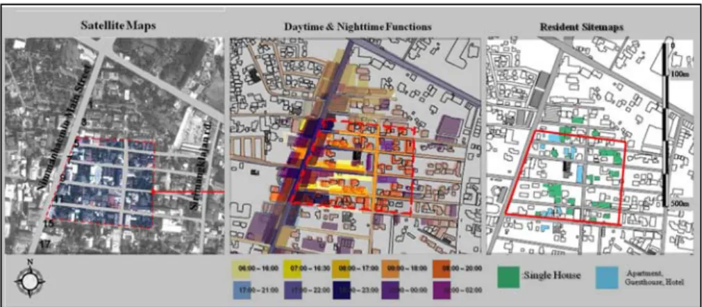
Figure4. Overlapped Daytime functions (orange zone) and Nighttime Functions (blue zone) on Nimmanhaemin sitemap (2012)
The first issue is zoning. According to present businesses which disturb the residential area, this research focuses on the relationship between timing and areas. To specify, area uses are highlighted as having either a day-time function (coloured by orange tones) or a night-time function (coloured by blue tone). Those colour tones represent periods of use on the site with lighter shades showing how early those uses are and darker shades show how late those uses are (Figure 4). After this surveying, overlapping colours on the sitemap determine areas where both day and night functions are, and where they potentially overrun and have already disturbed residents in the surrounding area. Those areas are on the main street and located on Soi 5, 7, 9 and 17 where cafes and night bars are mostly located.
Figure5. Controversies on Regulations in Nimmanhaemin District
The second issue is that there are no regulations for controlling new
investors. Nimmanhaemin District needs to create a balance between old
communities and present investment. Many new investors renovate and
build buildings freely. Without updating regulations, many shops have no
parking of their own and their customers often park their cars blocking
residential access. Many bars and nightclubs ruin residential areas with noise
pollution. In addition, many apartments and condominiums are built not
following regulations which restrict the height of buildings to 12 m. From
these conflicts, Nimmanhaemin needs to develop itself based on sustainable thought from its own community drive.
2. LITURATURE REVIEW & METHODOLOGY
2.1 Defining of “Neighbourhood”
The “Neighbourhood” concept, refers to the research of Nicholas N.
Patricios in 2002 which defines “Neighbourhood” as a retrospective of physical design and social interaction (Patricios (2002)). He claims that a major issue of “Neighbourhood” has arisen in the applications of both forms of the concept since the 1930s. This has been the assumption regarding the nature of the relationship between the way the physical environment is arranged and the linkage with social interactions between neighbourhood residents. Then, integrating “Neighbourhood” design into apartment planning, there is a focus on the following two issues.
First, physical design. Perry (1929) identified principles of the neighbourhood unit plan as a fixed size based on the service area of his research (an elementary school and communities nearby) with a one quarter mile walking distance, boundaries formed by arterial streets, scattered small parks and open spaces which formed ten percent of the total area, various institutional sites including a school at a central neighbourhood or community centre, local shops on the periphery of the neighbourhood, and an internal street system to discourage through traffic. These principles were all of physical perceptions. His summaries claimed that “physical design” is effective in terms of perceptions and also bounded people in the community towards being neighbours. In addition, he referred to perceptions of route and street scenes that potentially combined people and have represented friendliness and unity perceptively as “Neighbourhood” in terms of physical design.
Second, “social interaction”. Patricios referred to Perry’s research of approaching the physical-social continuum as opportunistic. To better understand his viewpoint it is necessary to briefly examine his personal experience (Perry (1921)), in particular, the progressive reforms activities in housing and social welfare that had begun in the late 19th century. The aim of the reformist movements was to improve social interaction so as to redress the urban environments that were seemingly hostile and anomic.
Perry proposed his neighbourhood unit concept with a central community centre where people of the neighbourhood could gather. The centre has to bound people with social participation. Those propositions explained that
“Neighbourhood” is to posit a community’s centre and is a place for the gathering of people with their needs or advantages.
2.2 The production of space
This research analyses data from questionnaires to identify relationships between people’s activities and areas. This method, when applied to studies on western modern cities and planning was edited by a French social scientist named Henri Lefebvre (Lefebreve (1992)) .
Lefebvre posits that “place” is a sort of "located-ness”. It is a geometrical
space and accounts for the fact that two things cannot occupy the same place
at the same time. In modern city planning, there is a managed grid system.
All the areas are controlled by government laws and rules. Governments give single meanings and function to each area. Lefebvre explained “place”
as “the representation of space”, but on the other hand, Lefebvre posits that
“space” is another kind of area and remains as "practiced place." In addition,
“spaces” are determined by historical subjects, by the users of places. Thus the street geometrically defined by urban planning is transformed into that area by walkers. Lefebvre explained that area as a “space” or
“representational space” which is on the other hand directly lived through its associated images and symbols, and hence the space of inhabitants and users. “Space” is flexible to users’ perceptions and historical and present geography. In the analysis section, this paper analyses areas which have potential characters as “space” to be able to restate an area and its design planning for integrating “neighbourhood” conceptual design into those areas.
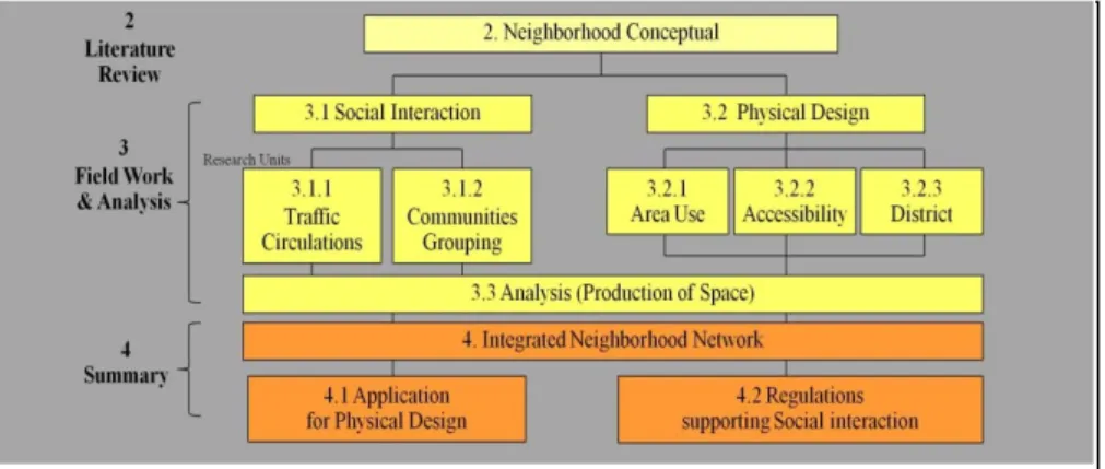
2.3 Methodology
The methodology of this study posits the neighbourhood concept combined with two areas of study; 3.1 Social Interaction and 3.2 Physical Design. In the analysis, the authors collect data from workshops and questionnaires to analyse the production of space in this district. As a minimum, this research aims to integrate the neighbourhood concept with two outcomes; 4.1 Application for Physical Design and 4.2 Regulations for Supporting Social Interaction (Figure 5).
Figure 5. Methodology
3. FIELDWORK & ANALYSIS
Since collecting resident data during 2008-2014, residential trends in Nimmanhaemin District are mostly explained by apartment and condominium investment activities. Caused by economic forces, land prices around Chiang Mai City, including Nimmanhaemin District, have increased rapidly. In 2008, those land prices that had cost around 20,000 baht/Sq.wah (1 Sq.wah = 4 Sq.m) had had their land prices grow to 50,000-70,000 baht/Sq.wah. within just five years (Akom (2012)) . For this reason, investors have to adapt their business strategies to gain an increased profit.
Condominium businesses have been massively invested in around the
Muang District over the last 15 years. In particular, a condominium unit’s
price, where located in the city center, has increased dramatically from
30,000 baht/Sq.m. in 2012 to 50,000 – 60,000 baht/Sq.m. in 2014 (CRUCMU
(2014)). Research lists the condominiums which were planned to be built
and constructed during the period 2009-2014 around the Nimmanhaemin
area. (Figure 6). Regarding urban regeneration, apartments and condominiums are connected to modern lifestyles and there also lacks community participation. This then leads to problems and complexities with old residences (single houses and row-houses).
Figure 6. New Residents on Nimmanhaemin Sitemap Since 2009
3.1 Field work: social interaction
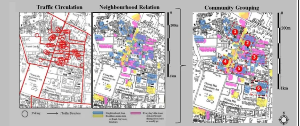
During March 2014, questionnaires were conducted to collect community data with 166 participants, which consisted of 62 residents and 104 workers around the district. According to the questionnaire, community relation and traffic circulation maps were created.
Figure 7. New Community grouping from traffic circulations and neighborhood relations
3.1.1 Traffic circulation
From questionnaires, the worst problem was “Traffic Jam” which could be managed via a government strategy. Regarding traffic circulation, questionnaire results have shown that the densest traffic in this district is on the east side where old residential and new investment buildings are located.
In particular, there is a 5.5 m. wide street which does not accommodate two- way traffic or parking on the side of the street. Moreover, questionnaire results found that primary solutions from residents are “Doing nothing” and
“Talking with Neighbours”. Those are individual tactics and solutions showing no sign of how government and community can solve this problem long-term.
3.1.2 Community grouping
This study collected zoning and area use data with local participation.
Divided areas were painted on a sitemap where they usually relate to
Neighbours (blue), Facilities (yellow) and Everyday uses (pink) (Figure 7).
These questionnaire results show areas which relate to each other as six new grouping communities. They include: Community 1, “Promenada”. This community covers Nimmanhaemin Soi 2 and 4 where there is a residential and daytime shopping area; Community 2, “Soi 1”. This community has had the strongest art and design district characteristics since 2000; Community 3,
“Soi 9”. This community is well-known as a dining spot. There are plenty of coffee shops, cafés and restaurants during the daytime and these convert themselves into bars at nighttime; Community 4, “Kantery Hills”. This community consists of apartments and condominiums where there is new residential zoning; Community 5, “Soi 17”. This area is another dining spot around Nimmanhaemin district. Each also has both daytime and nighttime function; Community 6, “Chiang Mai University’s Government Officials residence”. This area covers government officials’ housing and apartments.
An interesting point is that these communities are not related to the grid system on street network, but are connected by business types, social relations and old relationships.
3.2 Field work: physical design
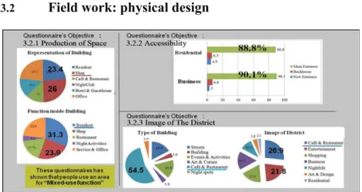
Figure 8. Questionnaire results: area use, accessibilities and image of district (March, 2014)
3.2.1 Production of spaces
From the questionnaires to analyse the area use, that data were combined. The type of buildings where people live and work is in shop- house (30.66%). Next are the apartments or condominiums (26.66%), followed by the new community plazas (25.33%). In addition, on average, 39% of buildings are classified as commercial (comprised of shops (26%),café/restaurants (13%), residential (23.4%) and offices (23.3%)). On the other hand, the functions inside those buildings are averaged for living (31.3%), commercial (23.9%) and office (22.9%). This data has shown that there are a variety functions which have tactics to convert residences into any business purpose flexibly in the same building. So, most of the buildings have “mixed use” functions.
3.2.2 Accessibility
This research divides accessibility into two kinds of functions, first is the residential function and second is for business function. The analyzed data are, first, accessibility for residential functions averaged as: 88.8%
using the main entrance (existing access), 6.3% using the new entrance and
4.9% using back-of-house to access their own residence. Secondly, accessibility for business functions averaged as: 90.1% using the main entrance, 6.8% using the new entrance and 3.0% using a back-of-house entrance. These results show that most buildings use the main street for accessibility which has the highest density of traffic during daily rush hours.
3.2.3 Image of the District
From residents’ questionnaires, the image of this district is a café and restaurant are (26.9%), entertainment area (21.8%) or a shopping district (17.9%). In addition, the most prevalent type of business is café and restaurant business (53.8%), followed by street (16.9%) and events (16.9%).
As a result, this district is primarily viewed as a dining and entertainment area which is for business purposes. The area is no longer seen as a residential area, nor are there many residents, relative to the past.
3.3 Analysis “the production of space”
From the community groupings there appeared to be community groupings which do not relate permanently to a grid system as much as the government strategy dictates. Instead they have occurred due to business fostering and residential purposes. The government strategy is to use guide boards for commercial businesses in front of each Soi. This has shown that the government just sees this district as commercial zoning on a grid system (Figure 9). As a result, research must focus on resident tactics.
Figure 9. Comparison government strategy and present area use on sitemaps
To define “place” referring to the production of space theory,
government strategy has planned Nimmanhaemin district as a business
district which is posited on a street network. From this, there appeared a
fostering of characteristics for each Soi, such as the art and culture district on
Nimmanhaemin Soi 1 and the coffee shops’ district on Nimmanhaemin Soi
9. Also, local government tried to announce each of them as shopping and
dining spots by using guide boards fronted on the main street, though even
through those strategies, it is hard to manage businesses growing following a
government plan. Because of this, each street has not had much support for
Small and Medium Enterprises (SME) and existing businesses. Other streets
have also had plenty of coffee shops, but they have been unable to maintain
their own businesses and profits, as much as for nightclubs and bars. For this
reason it is hard to identify any Soi as having only one main characteristic,
especially as no communities settled there originally.
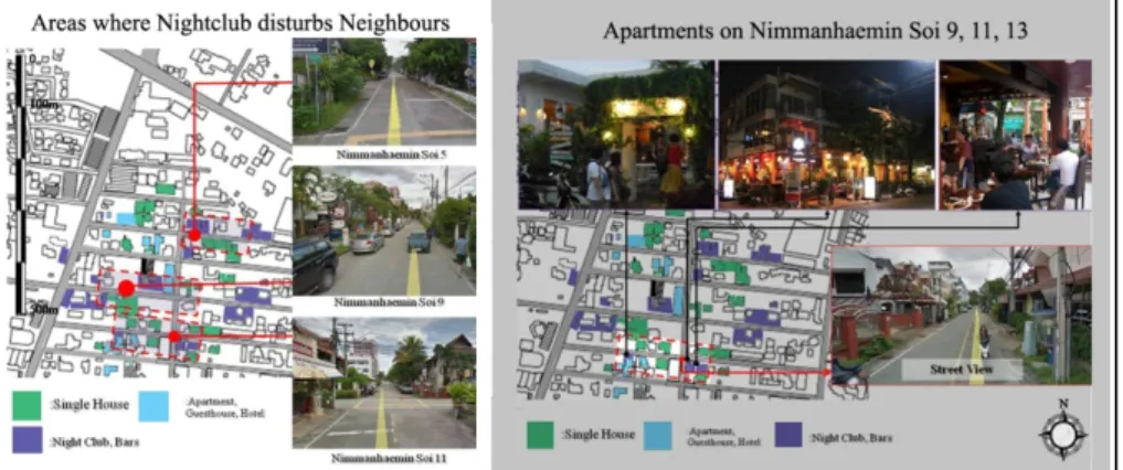
According to areas on Nimmanhaemin Soi 5, 7, 9 and 11, residents have employed their own tactics to maintain their businesses and make their profit increase. On activities analysis, this study identified tactics including:
converting old house, renovating shop-house, creating commercial courts, increasing night bars and new longitude community “condominiums”. These tactics only aim to maintain business purposes, but do not rely on existing residents, therefore those kinds of areas could be redefined for “space”
where it is flexible to meet users’ perceptions and historical and present geography following the production of space theory.
Figure 10. Conflicts between residential & nightclubs on Nimmanhaemin Soi 9, 11, 13
4. SUMMARY: INTEGRATING
“NEIGHBOURHOOD NETWORK”
Based on the analysis, an area surrounding Nimmanhaemin Soi 5, 7, 9 and 11 was chosen for further research as there have been conflicts between existing residents and nightclubs in this area regarding zoning. This area is overrun with and disturbed by noisy pollution, parking and traffic. With reference to related research, the attraction of this district is its great mixture of small-scale shops and activities, and is one of the liveliest hang out spots (Kulsrisombat 2008). For integrating “neighbourhood” concept, this district must first manage its zoning. “Physical Design” is the way to steer this area towards a community focus. This research presents applicable solutions for zoning between residential and other businesses in this area.
These applications will improve thoroughfares and the atmosphere in this district. In particular, current problems such as traffic jams, parking and zoning need to be solved. In addition, “Social Interaction” is required to support settling a community. This research suggests new regulations to control new investments and buildings around this district. These regulations will lead to the creation of an image for this district. Moreover, residents and other users will be a part of the community by participating in annual events and through volunteer activities.
4.1 Application for “physical design”
Referring to related research, Nimmanhaemin residents agree with the
residents of Chiang Mai city communities that there should be no expansion
of roads in the walled town of the old city, not only because road-building
there would add to, rather than solve, traffic problems, but because it would
also destroy their city’s unique characteristics (Sirorod and
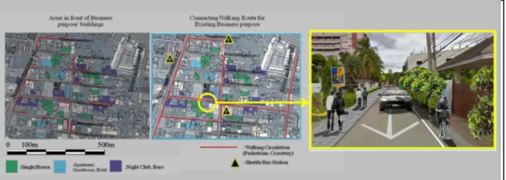
Ongsavangchai,2012). Because of this, this research gives solutions for managing complexities between residential and business purposes. This research posits the creation of a pedestrian route which connects to business communities and also manages zoning for residential areas. From surveying existing business communities in the area disconnected pathways and pedestrian areas which connect to Nimmanhaemin’s main street have been found to be lacking. This reason prevents businesses inside each Soi of Nimmanhaemin District from gaining as much profit as they could and also results in complexity between areas with both residential and business purposes.
4.1.1 Pedestrian route connected business communities
This research presents an idea for managing traffic on the odd numbered Sois by creating permanent walking routes which connect to Nimmanhaemin’s main street, existing business communities and nearby Sirimanklajan Street. This route would be presented on the neighbourhood relations’ sitemap. Accordingly, along the new pedestrian route, along with pavements, there should also be support for one-way traffic for cars, as well as a bicycle lane and also divided users’ routes from resident zones (Figure 11).
Figure 11. Physic design for zoning of areas with residential and business purposes
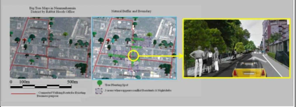
4.1.2 Natural boundary for residential and business purposes Following World Health Organization (WHO) recommendations, there is a recommended standard ratio for green areas in a city of 9 Sq.m./person. On the other hand, the Department of Public Works and Town and Country Planning of Thailand states the recommended ratio of green area at just 2.88 Sq.m./person. From Chiang Mai City Surveying during 2012-2013, Chiang Mai City (Muang District) has an overall green area of 1.28 Sq.km and the ratio of green area in Chiang Mai City has been calculated as 5.77 Sq.m./person (CRUCMU (2014)) . Because of this, an important issue for urban management in sustainable cities is to satisfy the ratio of green area per person as suggested by the WHO’s standard. From site surveying, residents use natural boundaries as a buffer for visual pollution from outside and nightclub noise pollution. For improving the physical design, this research supports that idea and includes natural boundaries to separate resident areas from business areas, especially nightclubs and bars, in its suggested planning solution. Natural boundaries would include planting trees along the street for blocking visual and noise pollution from other businesses. This would be a sustainable way to add to this district’s ‘green’
atmosphere and would divide zones currently lacking physical barriers. In
addition, these natural boundaries would create sunshade for people who walk along the pavement. Adding more green areas makes the image of the district more local and creative, as it used to be in the past (Figure 12).
Figure 12. Natural boundary planning
New pedestrian areas and natural boundaries should direct people who follow those routes to business communities and connect residents’ areas together. This plan for zones would allow areas with business purposes to smoothly blend in with areas with residential purposes. This physical design provides for three residential zones following the suggested planning solution (Figure 13).
Figure 13. New Physical Design for “Neighborhood” Network
4.2 Regulation for supporting social interaction
Three residential zones are to be divided based on building types considering their history and new geography (physical design). Those areas are then controlled depending on business types and should adhere to new regulations posited based on questionnaire results.
Zone A - “Single House”: This area covers single houses around the west side of Nimmanhaemin Soi 3, 5 and 7 where single houses continue to be maintained. Buildings in this area are old single house’s whose images represent original 80
thcentury architecture.
Regulations for Businesses in Zone A: Businesses in Community A represent friendly atmosphere that blends with the old housing context.
Existing businesses in this area are good examples for new businesses to
follow within this context. Businesses are converted single houses such as
coffee shops, restaurants and shops. In addition, these represent single
houses which fit in with the nearby context. Most of them are using tactics to
gain more profit as they are a part of the local representation of the area and
take advantage of their original buildings.
Zone B - “Row-house and Shop-house”: In this area, there is a variety of residential buildings, such as single houses, row-houses, shop-houses and apartments, with most being row-houses and shop-houses. In the original row-houses and shop-houses there is only one façade with shared construction and walls shared with neighbouring units. This community is divided into shop-house groupings and row-house groupings, but the strength of the character around this area is in its division by units which relate to a grid system and street networks.
Regulations for Businesses in Zone B: With modern development, each unit seeks to be outstanding, and also from a business perspective. Lots of businesses in this area have renovated shop-house units for making businesses purposes. Most of them use the tactic to attract people by designing façades and interior design dependent on the activities of the shop and the owner’s ideas.
Figure 14. Zone C “Apartment & Condominium”
Zone C - “Apartment and Condominium”: In these areas, many sections are already either planned for or developed as apartments and condominiums. With the potential of public facilities and business gains, there has been a rapid increase of condominiums.
New Regulations for Businesses in Zone C: Without limits and controls, condominiums are built without a corresponding strategy and are randomly designed just for business gains. The suggested regulations for this zone are:
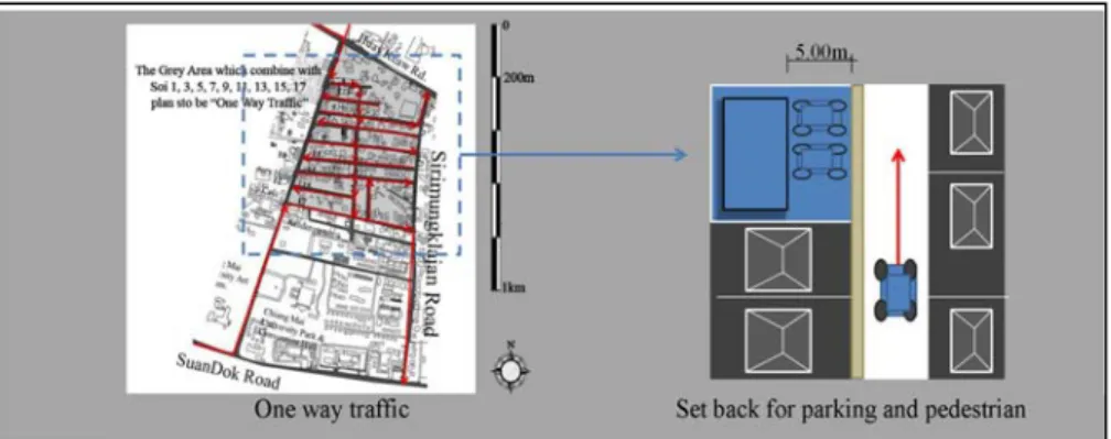
Traffic circulation on Soi 1, 3, 5, 7, 9, 11, 13, 15 and 17 is controlled with one-way traffic management for solving traffic jams and parking problems.
Apartments and condominiums in Zone C have to be setback from the street more than 5m to accommodate their own parking and drop-off areas.
Nightclubs must close before midnight and not disturb neighbours with excessive noise.
New apartments and condominiums in Zone C have legal height limits of up to 12m, following the government strategy for not blocking views of Suthep Mountain and possibility disturbing Air Plane Transportation
Apartments and condominiums in this community grouping should
have legally controlled façades and elevations which are not too diverse or
could possibly lead to a visually unattractive community; the façades and
elevations should be accepted by the community.
Figure 15. Zone C “Apartment & Condominium”
4.2.1 Integrating public circulation
This research assessed that physical design on this case could possibility be designed to make neighbourhood networks by creating nodes which would be able to accommodate activities promoting public thoroughfare connectivity. In order to create nodes for neighborhood networks, this research proposes a center for each community to connect residences. These areas lack public spaces in the community centre, such as a temple or religious statue, playground or park.
A questionnaire with residents collected information about residents’
behaviours regarding the use of community facilities and everyday life (See Figure 16). That data has shown that residents share the same amenities around the main street, like the supermarket, convenient stores and banks.
Those buildings could provide common areas for residents’ daily use. From this hypothesis, the researcher posits that those amenities along the main street should provide a public area for common use, the centre of this community, would then be in the area where convenient stores and shops are located, in front of Nimmanhaemin Street Soi 6-8.
Figure 16. Communities’ facilities (yellow) and everyday’s Life (pink) on Sitemap
(2012) From an apartment unit to a public space, every resident has to exit from the apartment’s first floor, therefore, the first floor of each apartment is an area in between public and private space. Apartments are designed for privacy and are closed, but that leads to residents lacking social interactions.
This research presents an idea for connecting thoroughfares from each apartment as a communal route. This communal route should bind all residents with social interactions and connect them with amenities (at the centre of the community). Therefore, this thoroughfare will connect residents and bind them at nodes, which allows for activities and thoroughfares to be created following the “Neighborhood Network”
hypothesis as well.
4.2.2 Events for supporting Social Interactions
On Soi 1, 4 and 9, the Nimmanhaein district officially holds annual events which represent their own images and communities. Soi 1 has held
“NAP (Nimmanahaemin Art and Design Promenade)” on the first week of every December since 1999, Soi 4 also advantages from that event by holding a flea market during the same time, and Soi 9 has held its annual Songkran Festival since 2013.
Apartment communities on Soi 9, 11 and 13 are primarily residential.
Social interactions for these communities come in two stages. The first important stage is to announce this area as a “Community” and hold a meeting for managing apartment representatives. Secondly, social interactions will eventuate from creating nodes. For supporting the minds and relationships of residents, social interaction should be created with mainly residents in mind. There is the possibility of holding a “Big Cleaning Day” annual event (All residents come and clean the public areas within communities) or an “Open House” flea market event (All residents share and sell their used items).
5. ACADEMIC CONTRIBUTION
Chiang Mai itself continues to grow rapidly without directions and a cutthroat business ethic is all too evident. The authors aim for this research to maintain and drive the Nimmanhaemin community as a creative district.
A summary of the research follows.
5.1 Community grouping on Modernity Planning
Figure 17. Community grouping on modern planning, a case of Nimmanhaemin District
Regarding the latest research in 2014, Chiang Mai City has been invested in for new business projects, including 74 condominiums, 18 mega projects and 28 superstores. This data shows how residential areas are the most invested in areas of the city, where there is support for public facilities and related offices (CRUCMU (2014)) . A community has to posit healthy networks. In the case of Nimmanhaemin district, this district has no cultural history and was originally planned for real estate following a grid system;
however communities presently are not bound by a grid system. In addition,
the number of high-rise residential and mixed-use properties has been
increasing (Figure 17). Surveying the communities, there appeared many
controversies about disturbances and zoning between existing residents and
new investors. Modern planning supports private transportation and real
estate for achieving business aims. Urban re-management is important to
create better situations for existing residents and investigators. An interesting point is that geography cannot be the only factor considered in order to claim those areas as one single community. From questionnaire results and site surveying, area uses and social relations are also identified as important issues for analysing community groupings. This result supports Nicholas N.
and Patricios’s “Neighbourhood” concept, which is a retrospective concept of physical design and social interaction.
5.2 Regulation related to current area uses
Figure 18. Various area uses in Nimmanhaemin District
Regulation is a government tool for controlling area uses. Nowadays, regulations have not been updated to concern existing residential properties.
Research results have shown that area uses are flexible and follow user purposes. This research studied the relationship between present regulations and the current problems communities face in order to suggest updates to community regulations. Regarding Henri Lefebvre’s ‘Production of Space’
theory, he describes that any area is defined by its “Place and Space” and concerns the area’s uses. Place is an area defined by Government from a single perspective, but according to research results, many areas and businesses around this district have evolved and gained various purposes which relate to the “Space” definition. Many buildings in the Nimmanhaemin district try to survive and take advantage of the changing space by altering the context of their businesses, such as converting old houses to shops, renovating shop-houses to suit other kinds of business and multiple businesses connecting together to form plaza areas (Figure 18).
Therefore, no regulations have been designed to last and they are required to adjust to the changing actions of residents and present area uses in each community grouping, on a case by case basis. Government should study and concentrate on current area uses in order to update regulation.
This research’s aim is to integrate “Neighbourhood” into this complexly zoned area by means of practical solutions, positing new community groupings, developing physical design and supporting social interactions.
These solutions were posited from research based on the “Production of
Space” and defining of “Neighbourhood” theories. This research is one of
many studies for settling communities sustainably and promoting urban
regeneration. Especially in developing countries, there are many complex
areas caused by modern thought’s urban planning. Without maintaining
existing communities, urban regeneration cannot be successfully suited with
existing residential stakeholders. A strategy should be formed and developed
based on a community focused approach.
REFERENCES
Akom. (2012). “Chiang Mai turns to condominium-department stores city: Crisis or chance”.Bangkok Business Newspaper Issue: December 20th 2012, Nation Publishing, Bangkok.
Brandon, P.S., Powel, J.A. (1984). Quality and Profit in Building Design, University Press, Cambridge.
Carta, M. (2007). Creative city, dynamic, innovations, actions, List, Barcelona.
Climate Change and Infrastructure Research Unit of Chiang Mai University (CRUCMU).
(2014). “Future of city planning in order of community and street by Chiang Mai people view”.in: Compass Magazine. .12(132)10-22, S.P. Publishing Group, Chiang Mai.
De Certeau, Michel. (1992). "Part III: Spatial Practices" in The Practice of Everyday Life, University of California Press, Berkeley, 117-130.
Dechana S., Ongsavangchai N. (2012). “The future of the Nimmanhaemin Neighbourhood”, Compass magazine , S.P. Publishing Group, Chiang Mai, 115(11).
Fale Nichola., Rudlin David. (1999). Building the 21st Century Home, Aniniprint of Butterworth-Heinemaun, Oxford.
Harrigan, John E. (1987). Human Factors Research: Method and Applications for Architects and Designs, Elsevier Science, New York.
Lefebvre Henri. (1992). The Production of Space, Wiley-Blackwell Publishing, New Jersey, 116-140.
Mitias, Michael H. (1994).Philosophy and Architecture, Atlanta LA., Amsterdam.
Niramon Kulsrisombat. (2008). “A case study of Chiang Mai, Thailand”.in: Sustainable City Regions: Space, Place and Governance, Springer Science + Business Media, Japan, 90- 98.
Patricios, Nicholas N. (2002) “Urban design principle of the original neighbourhood concepts”, Urban Morphology, University of Miami, Miami, 6(1), 21-32.
Perry, C.A. (1921). Ten years of the community centre movement, Russell Sage Foundation, New York.
Perry. C.A. (1929). “The neighbourhood unit”, Committee on Regional Plan of New York and its Environs (ed.) in: Neighbourhood and Community Planning. Commitee on Regional Plan of New York and itsEnviros, New York, (7), 20-141.
Sanoff, H. (1991). Visual Research Methods in Design, Van Nostrand Reinhold, New York.