and Community Preferences for Rural Development
after the Enactment of Village Law 6/2014:
A Case Study of Indragiri Hulu Regency, Riau
Province, Indonesia
Yustinus Ari WIJAYA, Kazuhiko ISHIHARA
Abstract
Village Law 6/2014 is a national policy for rural development that adopts a community-driven development system; it was initiated by the Kecamatan/sub-District Development Program and National Program for Community Empowerment. This paper discusses the evolution of community-driven development (CDD) policies in Indonesia and community preferences for rural development, based on lessons from Indragiri Hulu Regency, Province of Riau. Stakeholder perceptions and assessments at the district and village levels of rural development were analysed in the basis of a field survey conducted in early 2017. The results show that the role of the village officials has become very significant since these officers have been given the authority to manage development resources. The participation of ordinary villagers, which is one of the purposes of this national policy, is unfortunately still relatively limited when compared to the involvement of village officials. Village officials appear to be the most satisfied with the implementation of this Village Law, and they assess the policy as being better than previous CDD programs. Stakeholders in the village claim that village road development is the highest-priority infrastructure in rural areas. Since village development planning focuses on solely infrastructure development to support the rural community’s economy, the negative impacts on changing land use have not yet been considered in rural development.
Keywords: rural development, community-driven development, village law 6/2014, policy
1.Introduction
Development in Riau Province is inseparable from the agriculture sector, especially oil palm plantations, which have made an enormous contribution to the economic growth of Riau, along with several other sectors (mining and industries) (Budidarsono et al. 2013). It was estimated that up to 2016, oil palm plantations in Riau accounted for 2.46 million hectares or 21.09% of the total oil palm plantations in Indonesia, making it the largest site of oil palm plantations in Indonesia (Ministry of Agriculture, 2016).
development in the future. On the other hand, however, it also affects the environment, particularly in land use changes due to deforestation, invasion of peatland, etc. (Budidarsono et al., 2013). Wicke et al. (2011) stated that better regulation and spatial planning are major factors in reducing the problems of land use change, including determination of boundaries for the clear demarcation of forests, peatlands, protected areas and improved supervision of land use. In the National Spatial Planning System, there are several different levels of spatial planning in Indonesia.1 The spatial plan is a reference for central and local government in development planning.
Rural infrastructure supports the development of villages, not only in the agricultural sectors but also in non-agricultural sectors. Gibson and Olivia (2010) revealed that the poor access and quality of infrastructure hinder the development of non-agricultural enterprises in rural Indonesia. For the agricultural sector, rural infrastructure is closely associated with the development of oil palm plantations. Feintrenie et al. (2010) acknowledged that isolated areas and those that lack accessibility are the last areas to benefit from the development of oil palm plantations.
Studies on the relationship between accessibility and land transformation have been extensively conducted. Castella et al (2005), had conducted a research study to a mountainous province of northern Vietnam, indicate that the accessibility, availability and management of a village’s natural resources affect the changing patterns of land use. However, from their results in western Honduras, Nagendra et al. (2003) argue that accessibility enabled by road infrastructure development does not necessarily lead to deforestation and land use change; indeed, in some cases, they found the opposite.
Prior to the enactment of Village Law 6/2014,2 infrastructure at the village level was implemented by the district,
provincial and central governments through CDD programs. After the fall of the New Order regime in 1998,3 there
are two major national CDD programs in Indonesia: the Kecamatan/sub-District Development Program (PPK/ Program Pengembangan Kecamatan) and the National Program for Community Empowerment (PNPM/Program Nasional Pemberdayaan Masyarakat). These programs aim to alleviate poverty in rural areas through community empowerment. Since 2014, CDD programs have been replaced by Village Law 6/2014 (ADB, 2016).
Village Law Number 6 of 2014, which was followed by Government Regulation Number 22 in 2015 on Village Funding, provides significant direct budget disbursement sharing to villages from a combination of central and local government budgets. The policy empowers communities and village governments to manage their own finances and implements village-scale infrastructure development. Many believe that channelling significant funds directly to villages will benefit the rural communities. However, there are also concerns that the implementation of Village Law 6/2014 will not have any more of a positive impact than previous CDD programs (ADB, 2016).
Rural development policy can be broadly defined as any action taken by governments, solely or together with donors, which directly or indirectly may affect the nature of economic and social development in rural areas (Ashley & Maxwell, 2001; Ellis & Biggs, 2001). Many studies show that significant changes in land use, in the form of deforestation, are often the unaccounted effect of national policies on issues unrelated to the management of natural resources (Nagendra et al., 2003). The extent to which rural development policy contributes, through Village Law 6/2014, to agricultural development and how it affects spatial change at the rural level needs to be examined further. On the basis of the research background mentioned above, and to get a better understanding of government policy in rural development, it is important to answer the question, ‘What are the differences between Village Law 6/2014 and the previous rural development programs?’ This question serves as a starting point for a close examination of the relationship between rural development policies, accessibility and agricultural development as well as their impact on spatial planning.
A previous study by Asian Development Bank (ADB) in 2016 on the ongoing transition of CDD programs to national policy in rural development through the implementation of Village Law 6/2014 yielded some important
findings. One of the most important findings is that the community participatory planning processes initiated by CDD programs have been widely spread and integrated into local development system plans. Another interesting finding is the central role played by local government in implementing Village Law 6/2014. The diverse institutional capacities of local governments will be challenging the implementation of Village Law 6/2014, especially in the first few years.
Key findings from the above ADB study are discussed to investigate more deeply about community-based development in rural areas. This paper examines the participation, roles and preferences of rural communities in implementing participatory development planning. Furthermore, spatial planning considerations in rural development planning are also examined. The findings in this paper will provide significant input to all stakeholders involved, for continuous improvement during the implementation of Village Law 6/2014. In addition, this paper can contribute to scientific insight regarding the current conditions in the implementation of Village Law 6/2014 through the case study of Indragiri Hulu Regency.
This paper discusses the implementation of CDD after the enactment of Village Law 6/2014, preferences in development and the stakeholders’ perspectives at the district and village levels. The objectives of this paper are:
1. to identify fundamental differences in Indonesia’s rural development system after the enactment of Village Law 6/2014;
2. to examine the shifting roles and participation of rural communities on the development in practice; 3. to investigate the preferences of rural communities for infrastructure development;
4. and to review the extent to which the development planning of rural infrastructure has been considered in the context of spatial planning.
2.The Study Site
Indragiri Hulu Regency is located in the southern part of Riau Province in Sumatra Island. It has an area of about 8,198.26 km2, consisting of 14 sub-districts divided into 178 villages and 16 kelurahan4 (Figure 1). In 2015, the population
was 409,431 inhabitants, and the population density was 49 people per square kilometre (BPS, 2016).
The agricultural sector comprises 22.59% of the Gross Regional Domestic Product (GRDP) of Indragiri Hulu Regency. Oil palm and rubber tree plantations are the most conventional farms in this Regency. The total area of these plantations reached 1,803.41 km2, or about 22%, of the total area of Indragiri Hulu Regency (BPS, 2016).
Indragiri Hulu was selected as the study area because it is one of the regencies in Riau that has experience first-hand of the benefits and impacts of oil palm plantation development described above. In addition, Indragiri Hulu was the first plantation introduce for palm oil in 1976, with a total area of only 10 km2 (Hidayat, 2006). Yet in 39 years,
the area of oil palm plantations in Indragiri Hulu has expanded rapidly, reaching 1,189.69 km2 in 2015 (BPS, 2016).
Thapa et al. (2013) point out that Indragiri Hulu Regency and other districts in Riau have experienced a massive deforestation process, which could have a significant environmental impact in the future if there are no prudent scenarios to deal with it.
3.Methodology
First, secondary data of national policies, such as legislation, implementation guidelines and other rules related to rural development policies, were collected. Further data collection was conducted at the district level. Other secondary data were also gathered, such as the District Spatial Plan, District Development Plan, road databases, documents and reports from several agencies in Indragiri Hulu Regency (Development Planning Agency, Public Works Agency, Village Empowerment Agency, and Regional Financial and Asset Management Board), and a review of previous studies related to the research topic was undertaken.
Secondly, the primary data were obtained through in-depth interviews with two key informants at the district level (Head Division of the Village Empowerment Agency and Head Division of Village Administration of Indragiri Hulu Regency), who have been involved with the rural development for more than five years.
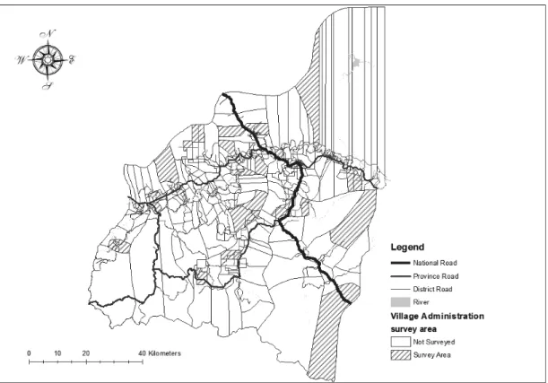
In addition, field observations and surveys were conducted of 140 respondents from 28 villages in 14 different sub-districts, selected using a purposive sampling approach.5 The field study sites were conducted by selecting two
villages per sub-district considered to represent the geographical, demographic and rural infrastructure conditions in the sub-district administration (Figure 2). This method was implemented due to the time constraint and limited resources.
Figure 1. Location of Indragiri Hulu Regency in Riau Province
Source: The map of Riau is retrieved from http://big.go.id/; and the map of Indragiri Hulu is from Indragiri Hulu’s Road Database 2016, Public Works Agency of Indragiri Hulu.
A questionnaires survey was conveyed to 140 respondents, divided into two groups, namely, common villagers6
(90 respondents) and village officials7 (50 respondents). The implementation of the survey was conducted by direct
interview method and assisted by two enumerators. The number of common villager respondents in each village varied between three and four respondents, while the number of village officials varied between one and two respondents in each village.8 Questions were asked about the participation, assessment and expectations of rural
communities with regard to rural development in Indragiri Hulu.
The grouping of respondents based on the level of village accessibility was conducted to determine the linkages between the accessibility and priority of rural infrastructure types. The level of accessibility in this study is defined by distance and travel time to the government office and economic center in Indragiri Hulu Regency. The parameters used are distance to sub-district and district capital, which is the location of the government office as well as the economic center, and proximity to a main road (national, provincial and district), which influenced transportation time.
Primary and secondary data were analysed using a qualitative approach and supported by quantitative data that was used to identify how Village Law 6/2014 differed from previous rural development programs. In addition, the analysis also identified the assessment and preferences of village communities for infrastructure in rural development.
Figure 2. The survey areas
4.Rural Development Policies in Indonesia
4.1.The Concept of Rural Development
There are several formulations of the idea of rural areas, for which the sense and the area covered is different in each country. Amdam (2004) argues that each country has perceptions and definitions of rural areas that depend on the political structure, institutions, administration, landscape conditions, population density, communications and connections between rural and urban areas, which will affect spatial planning in the countryside. The classification of rural areas in Indonesia is defined as a village-level (desa/kelurahan) administrative area that has not met certain statistical requirements such as the population density, a percentage of agricultural households, urban facilities, formal education facilities, public health facilities etc.9
In a rural development strategy, there are five principles for successful rural development:
Recognize the great diversity of rural situations; respond to past and future changes in rural areas; be consistent with wider poverty reduction policy; reflect wider moves to democratic decentralization; make the case for the productive sectors in rural development, both as a strategy to maximize growth and to reduce poverty. (Ashley & Maxwell, 2001, p. 418)
Ellis and Biggs (2001) point out that a change of themes has occurred in the implementation of rural development in developing countries from the 1950s to the 2000s. They argue that the evolution of rural development themes can be grouped thus:
From community development (1950s) to the emphasis on small-farm growth (1960s); continuing small-farm growth within integrated rural development (1970s); from state-led rural development (1970s) to market liberalization (1980s); process, participation, empowerment and actor approaches (1980s and 1990s); emergence of sustainable livelihoods as an integrating framework (1990s); mainstreaming rural development in poverty reduction strategy papers (2000s). (Ellis & Biggs, 2001, p. 444)
The concept of rural development for poverty alleviation through community empowerment programs, better known as CDD programs, has been known in Indonesia since 1998 through the implementation of the Kecamatan/ sub-District Development Program (KDP). This program emerged along with the collapse of the New Order regime (1966–1998), which was too centralised, and replaced by the Reformasi Order.10 The centralised government, uniformity
and top-down development policy of the New Order era were replaced by reliable and responsive local-level institutions through political reforms that began in 1998 (Antlov, 2003). However, the Government of Indonesia only adopted this CDD into a national policy for rural development with the enactment of Village Law Number 6 of 2014 (ADB, 2016).
4.2.The Evolution of Community-driven Development Programs into Village Law 6/2014
The implementation of the KDP in 1998 marked the beginning of a community-driven development (CDD) program in Indonesia. In general, the KDP aims to alleviate poverty through community empowerment, by providing block grants to the poorest sub-districts in Indonesia in order to promote small-scale infrastructure development and for social and economic activities. Block grants are distributed directly to the sub-districts, while villages compete by proposing projects to obtain funds. The funds disbursed by the government to sub-districts through the KDP vary
from Rp500 million to Rp1 billion ($57,000 to $114,000). In the period from 1998 to 2006, the KDP reached 34,103 of the poorest villages in 2,000 sub-districts in Indonesia, recognised as Southeast Asia’s largest CDD program (Gibson & Woolcock, 2008).
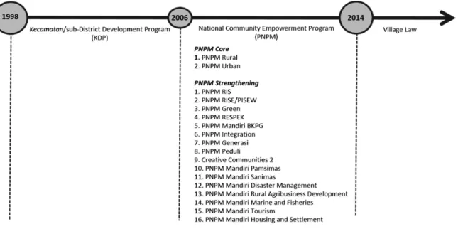
Continuing the successful implementation of the KDP, the government launched the Program Nasional Pemberdayaan Masyarakat (PNPM) or National Program for Community Empowerment. The implementation of the PNPM makes the CDD program a national strategy for the alleviation of poverty. The PNPM consists of two core programs (PNPM Core), namely, PNPM Urban and PNPM Rural, and some strengthening programs (Figure 3). The program has grown rapidly, and by 2013, the PNPM Rural subprogram had covered almost 75,000 villages in all districts in Indonesia and was recognised as the world’s largest CDD program (ADB, 2016). The block grant disbursed to sub-districts varies between Rp750 million and Rp3 billion, a significant increase from the KDP block grant.
In general, there is not much difference between the PNPM Rural and the KDP regarding system and program structure, and there are only minor improvements, based on previous KDP implementation evaluations. The fundamental principles of the KDP are community participation, empowerment of the rural poor, transparency, information sharing, sustainability, simple strategies and methods and healthy competition for funds; these principles are still implemented by the PNPM Rural. The implementation of the PNPM Rural is recognised as having had a positive impact on empowerment and on poverty reduction in rural communities. However, the evaluation by the Tim Nasional Percepatan Penanggulangan Kemiskinan (TNP2K/the National Team for the Acceleration of Poverty Reduction) of the PNPM in 2015 showed that there are still some limitations to the implementation of the PNPM (TNP2K, 2015) (Table 1).
After the PNPM program, the Indonesian government adopted the community empowerment form initiated by the KDP and the PNPM into a national strategy for rural development, with the enactment of Village Law Number 6 of 2014. This law incorporates a formal top-down policy development format with the form of community participation that had been practiced by CDD programs. Continuity in planning and implementation of development
Figure 3. CDD programs in Indonesia.
between Village Law 6/2014 and previous community-based programs can be seen in the involvement of community participation in the preparation of the Rencana Pembangunan Jangka Menengah Desa (RPJM Desa)11 through village
meeting mechanisms. RPJM Desa has been introduced to the village community since the implementation of the PNPM Rural and has been a primary requirement in Village Law 6/2014 to obtain village development funds (ADB, 2016).
The most prominent difference in the implementation of Village Law 6/2014 is the significant increase in the block grant for development funds, known as ‘Dana Desa’ or Village Funds, sourced from the state budget, that is, the direct disbursements to villages across Indonesia12 (Table 2). The formalisation of this CDD strategy into a national
policy led to changes in financial management for rural development. The village government has considerable authority and responsibility as a financial and project administrator, in contrast to CDD programs, which established the local community unit/organisation as the managers of activities. Nevertheless, the community remains involved in the decision-making process through village meetings and the development processes (Table 3).
Table 1. Results of PNPM Rural (2007–2014)
Strengths Limitations
• Poverty alleviation in rural households • Poverty alleviation in marginal areas • High-quality, cost-effective infrastructure • Improved access to some services
• More inclusive participation for rural women and the poor • Improved transparency and accountability at community and
sub-district levels
• Improved transparency and accountability in program oversight
• Maintenance for sustainability
• Low uptake of PNPM governance mechanisms outside the program
• Shortcomings and weakening of governance mechanisms • Lagging monitoring systems and responses to corruption • Facilitators are critical to PNPM objectives and sustainability,
but scarce and overworked
Source: TNP2K, 2015
Table 2. Roadmap of Village Funds in State Budgets (2015–2019)
No. Category 2015 2016 2017 2018 2019
1. Transfer of Funds to District (million $) 49,526 55,630 62,450 79,839 86,031
2. Village Fund (%) 3.23 6.40 10 10 10
3. Village Fund (million $) 1,600 3,560 6,245 7,984 8,603
4. On Average per Village ($) 21,590 47,627 83,540 106,803 115,085
Note: Budget figures were originally provided in Indonesian rupiah and converted to US dollars using the exchange rate IDR13,000 = $1.
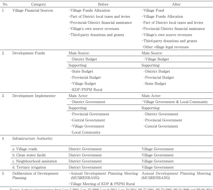
4.3.Significant Changes in Financial Resources and Rural Infrastructure Authority after the Enactment of Village Law 6/2014
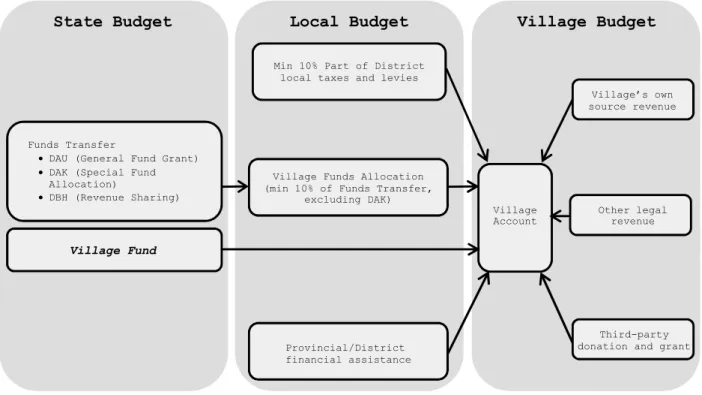
Before the enactment of Village Law 6/2014, the primary source of village finances for development came from Village Funds Allocation and was supported by several other sources, such as provincial/district financial aid, local tax sharing and district levies, the village’s own revenues and third-party assistance. Following the enactment of Village Law 6/2014, the Village Fund, sourced from the state budget, became a primary source of rural development financing (Figure 4). All sources of development funds, whether derived from the state budget, provincial budget, district budget or village revenues, are included in the Village Budget and managed by the village government under RPJM Desa and RKP Desa. The Village Budget and RPJM Desa comprise an effort by the Indonesian government to implement ‘One Plan, One Budget’ in rural development, with the expectation that rural development will be well
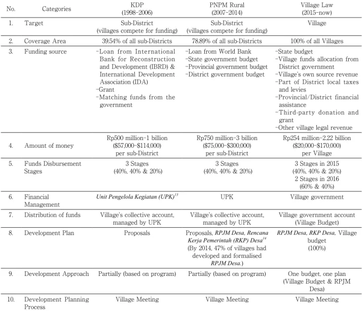
Table 3. Comparison between KDP, PNPM Rural and Village Law
No. Categories (1998-2006)KDP PNPM Rural(2007-2014) Village Law(2015-now)
1. Target Sub-District
(villages compete for funding) (villages compete for funding)Sub-District Village
2. Coverage Area 39.54% of all sub-Districts 78.89% of all sub-Districts 100% of all Villages
3. Funding source -Loan from International
Bank for Reconstruction and Development (IBRD) & International Development Association (IDA)
-Grant
-Matching funds from the government
-Loan from World Bank -State government budget -Provincial government budget -District government budget
-State budget
-Village funds allocation from District government
-Village’s own source revenue -Part of District local taxes
and levies
-Provincial/District financial assistance
-Third-party donation and grant
-Other village legal revenue 4. Amount of money Rp500 million-1 billion($57,000-$114,000)
per sub-District Rp750 million-3 billion ($75,000-$300,000) per sub-District Rp254 million-2.22 billion ($20,000-$170,000) per Village 5. Funds Disbursement
Stages (40%, 40% & 20%)3 Stages (40%, 40% & 20%)3 Stages (40%, 40% & 20%)3 Stages in 2015 2 Stages in 2016
(60% & 40%) 6. Financial
Management Unit Pengelola Kegiatan (UPK)
13 UPK Village government
7. Distribution of funds Village’s collective account,
managed by UPK Village’s collective account, managed by UPK Village government account (Village Budget)
8. Development Plan Proposals Proposals, RPJM Desa, Rencana
Kerja Pemerintah (RKP) Desa14
(By 2014, 47% of villages had developed and formalised
RPJM Desa.)
RPJM Desa, RKP Desa, Village budget
(100%)
9. Development Approach Partially (based on program) Partially (based on program) One budget, one plan
(Village Budget & RPJM Desa)
10. Development Planning
Process Village Meeting Village Meeting Village Meeting
integrated.
In addition to changes in development funding sources, since the enactment of Village Law 6/2014, there have also been shifts in authority for rural-scale infrastructure construction and maintenance. The role of the district government as the implementer of rural development has decreased, whereas the role of the village government has increased significantly. Table 4 describes some changes in rural development after the enactment of Village Law 6/2014.
The ADB study (2016) shows, from the perspective of the district government regarding the implementation of Village Law 6/2014 as a national policy of rural development, that the law had several effects on the district government’s financial programs and budgeting in terms of the adjustment of work programs already allocated by the village; changes in the share of responsibility for development between district and village governments; and the need to monitor and improve the capacity of village governments in governance, financial absorption and development implementation. Meanwhile, from the perspective of the village head, there were concerns about the limitations of their knowledge in managing the relatively large amount of Village Funds, which might have legal consequences. Therefore, they suggested the need for supervision and capacity building from higher authorities, as well as a clear policy and guidelines on implementation, financial governance and other audits and oversight.
Figure 4. Village financial sources.
5.Spatial Planning and the Agricultural Sector in Indragiri Hulu Regency
The purpose of this chapter is to provide a brief overview of the spatial plan and development of the agricultural sector in Indragiri Hulu Regency. The description of the agricultural sector and the spatial plan is needed to better understand the context of community preferences and perspectives in rural development.
5.1. A Brief Overview of Spatial Planning
Healey (1997) reveals that spatial planning initially emerged in response to the environmental conditions during the Industrial Revolution, when land-use zoning protected residential areas from industrial pollution and limited the development of built areas. Many scholars define spatial planning in their own way, but it can be briefly grouped into
Table 4. Rural Development before and after the Enactment of the Village Law
No. Category Before After
1. Village Financial Sources -Village Funds Allocation -Village Fund
-Part of District local taxes and levies -Village Funds Allocation
-Provincial/District financial assistance -Part of District local taxes and levies
-Village’s own source revenues -Provincial/District financial assistance
-Third-party donations and grants -Village’s own source revenues
-Third-party donations and grants -Other village legal revenues
2. Development Funds Main Source: Main Source:
-District Budget -Village Budget
Supporting: Supporting:
-State Budget -District Budget
-Provincial Budget -Provincial Budget
-Village Budget -State Budget
-KDP/PNPM Rural
3. Development Implementer Main Actor: Main Actor:
-District Government -Village Government & Local Community
Supporting: Supporting:
-Provincial Government -District Government
-Central Government -Provincial Government
-Village Government -Central Government
-Local Community 4. Infrastructure Authority:
a. Village roads District Government Village Government
b. Clean water facilit District Government Village Government
c. Neighbourhood sanitation District Government Village Government
d. Tertiary irrigation District Government Village Government
5. Deliberation of Development
Planning -Annual Development Planning Meeting (MUSRENBANG) Annual Development Planning Meeting (MUSRENBANG) -Village Meeting of KDP & PNPM Rural
three activities: the determination of future land-use plans, enhancement of area properties and arrangements for managing new situations (van Lier, 1998).
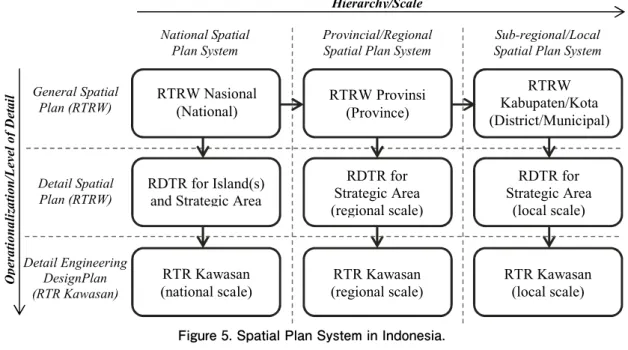
The Indonesian Spatial System is under Law Number 26 of 2007 on Spatial Planning. On the basis of a hierarchy, the spatial system is separated into three categories, namely, the National Spatial Plan System, the Provincial/ Regional Spatial Plan System and the sub-Regional/Local Spatial Plan System (Figure 5). At the level of detail, it is divided into the General Spatial Plan, the Detail Spatial Plan and the Detail Engineering Design (Hudalah & Woltjer, 2007). The District Spatial Plan corresponds to the lowest level in the hierarchy of the national spatial system (the sub-Regional/Local Spatial System Plan). The most detailed spatial plan at the district level is the Spatial Detail Plan (RDTR), which refers to the Regulation of the Minister of Public Works No. 20/PRT/M/2011 in the Guidelines for
the Detailed Spatial Plan and Zoning Regulation.
Up to now, there has been no adequate spatial plan at the village level for rural development. The District Spatial Plan is often too generalised and does not take into account land-use changes, needs and preferences at the village level (Limberg et al., 2006). The conditions and problems in each village vary according to the circumstances and developments. Amdam (2005) warned of the dangers of generalising about situations and challenges in rural areas; rural spatial planning should be able to adapt to specific issues and cases in each region. Sufficient vision, strategies and implementation, supported by residents, organisations and other actors, are urgently needed in rural spatial planning.
5.2.The Agricultural Sector in Indragiri Hulu
Agriculture has contributed significantly to the economic growth of Indragiri Hulu Regency. In 2015, the contribution of the Gross Regional Domestic Product from this sector accounted for 22.59%, the largest proportion of
Figure 5. Spatial Plan System in Indonesia.
all categories (BPS, 2016). Data from 2011 to 2015 show a relatively stable trend of GRDP for this sector. Plantations are the largest sub-sector contributing to GRDP; on average each year, this sub-sector accounts for 67.07% of the agricultural sector (Table 5). Budidarsono et al. (2013) suggest that the future expansion of oil palm plantations will continue to meet the needs of domestic consumption and an increase of international interest in biofuels as an alternative to fossil fuels. Thus, this certainly offers potential for the economic growth of rural communities.
Oil palm plantations in Indragiri Hulu Regency have great potential in terms of area and production. The area of oil palm plantations in Indragiri Hulu in 2015 was 1,189.69 km2 or 14.51% of the total area of the district, and this type of plant is the
primary commodity in Indragiri Hulu. According to the Agriculture Census of 2013, 31,345 households, or 32.93% of the total households in Indragiri Hulu, relied on oil palm plantations to provide work. Production of oil palm plantations in Indragiri Hulu District in 2015 reached 423,636 tons or 5% of the total output of oil palm plantations in Riau Province (BPS 2016).
5.3.Spatial Pattern in Indragiri Hulu’s Spatial Plan
On the basis of the District Spatial Plan of Indragiri Hulu15 2011–2031, the spatial pattern of the district is divided
into two: the spatial pattern of protected area and the spatial pattern of the cultivation area. The grouping of protected and cultivation areas has been regulated under Indonesian laws and regulations.16
The Plantation Area consists of smallholder plantations and large-scale farms; most of the plants in Indragiri Hulu are oil palm crops, followed by rubber. Distribution of smallholder farms and large plantations based on the Spatial Plan of the Regency is as follows:
1. Smallholder farm area, located in all sub-districts in Indragiri Hulu Regency, with a total area of approximately 688.93 km2.
2. Large-scale plantation area, located in all sub-districts in Indragiri Hulu Regency, with a total area of approximately 3,060 km2.
By 2031, the total area of farms planned in Indragiri Hulu Regency Spatial Plan for all plantation types will be 3,748.93 km2. Oil palm plantations will reach 65.30% of the total plantation area, with the result that Indragiri Hulu
Regency will prepare zoning for oil palm plantations up to 2031 of 2,448.29 km2 of land. This means that the Indragiri
Hulu Regency government estimates that there will be a significant increase in oil palm plantations of more than 100% in the next 16 years.
The zoning pattern of Indragiri Hulu Regency is set out in the District Spatial Plan Map, which is part of the
Table 5. Contribution of Agriculture, Forestry and Fishery Categories to GRDP (%) 2011–2015
No. Business Field 2011 2012 2013 2014 2015
1. Agriculture 76.60 77.61 78.33 79.49 78.06
a. Food crops and horticulture 4.00 4.00 4.18 4.12 4.44
b. Plantation crops 66.39 67.27 67.34 68.48 65.93
c. Other agriculture 6.20 6.35 6.81 6.90 7.68
2. Forestry and logging 20.96 19.88 18.92 17.64 19.02
3. Fishery 2.44 2.51 2.75 2.87 2.92
Agriculture, Forestry, and Fishery 100.0 100.0 100.0 100.0 100.0
Spatial Planning of Indragiri Hulu Regency 2011–2031. However, the zoning map is still in macro scale for the district; a more detailed spatial plan is needed that can be used as a reference for the implementation of rural development in order to deal with challenges and changing situations in the future, since rural areas are the most affected by changes in spatial layout due to the development of plantations at the village level. Patsy Healey (1997, p. 72) writes,
As a field of public policy practice, spatial planning has evolved from different origins in different places. It involves two levels of governance, as any policy field, that of systems of law and procedure which set the ground rules for specific practices, and that specific instance, where various parties come together to undertake planning work.
In practice, a planning system is often not implemented because of several factors. Blowers (1993) argues that factors such as professional jealousy, inadequate training and fear that people will lose their jobs if control over the spatial plan is too tight at the local level caused the spatial planning system to be abandoned in practice. This shows the importance of engaging all important stakeholders, businesses and non-governmental organisations in building community-based planning systems (Amdam, 2005). This statement is consistent with the proposal by Healey (1997) that spatial planning be a collaborative process between several parties to solve the problems that occur by combining several new initiatives.
Development of the spatial planning process at the village level is very important because each village has varied circumstances that distinguish it from other regions. Rural development cannot be separated from spatial planning, because the ‘objective of land-use planning is to improve the countryside for the long-term: a sustainable rural system’ (van Lier, 1998, p. 90).
6.Comparison of Preferences between Common Villagers and Officials in Indragiri Hulu
6.1.The Development of Rural Infrastructure in Indragiri Hulu
In Chapter IV, the differences in rural development after the enactment of Village Law 6/2014 were described. This chapter discusses the development of rural infrastructure in Indragiri Hulu Regency built through CDD programs and Village Law 6/2014. The CDD program was first introduced in Indragiri Hulu Regency through the KDP in 1998, where 15 villages in two sub-districts (Kecamatan Pasir Penyu and Kecamatan Seberida) had an opportunity to run the program. In 2014, which was the last year of PNPM Rural implementation, all villages in Indragiri Hulu, totalling 194 villages, participated in the CDD program.
In addition to the KDP and PNPM Rural, there was one CDD program implemented in Indragiri Hulu Regency, namely, PNPM RIS (Rural Infrastructure Support). PNPM RIS is a strengthening program of the PNPM; its focus is the development of rural infrastructure through community empowerment programs. PNPM RIS, which began in 2009 and ended in 2014, was only implemented in four provinces, namely Riau, Jambi, South Sumatra and Lampung. Unlike PNPM Rural, PNPM RIS block grants were directly channelled to the village through the accounts of Local Community Organisations and were used entirely for the development of rural infrastructure. The use of funds for economic or social activities was not allowed under this program.
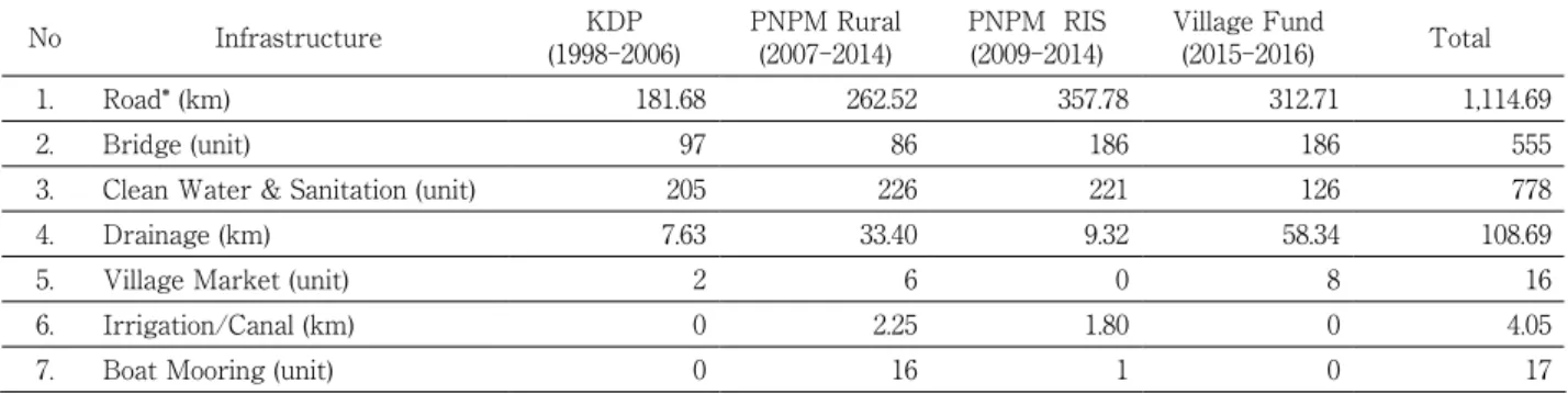
In the period of 1998–2016, many rural infrastructure projects were built in Indragiri Hulu Regency (Table 6). The significant increase in rural infrastructure development that occurred during the two years of the Village Law 6/2014 implementation is understandable, due to the larger amount of Village Funds and the direct disbursement to villages without their having to compete to obtain the funds. Significant improvements in village financial resources
derived from the Village Fund and Village Fund Allocation provide greater opportunities for communities and village governments in infrastructure development (Table 7).
In 2015, about 92% of the total Village Funds in Indragiri Hulu Regency was used for infrastructure development, and in 2016 it even reached 99% of the total. Other sectors, such as village administration, community development and community empowerment, received tiny portions. Based on Village Law 6/2014, there are nine priority uses of Village Funds in terms of infrastructure development, namely, construction and maintenance of rural roads; construction and maintenance of farm roads; construction and maintenance of village ponds; development of new and renewable energy; development and maintenance of neighbourhood sanitation; development and management of village-scale clean water facility; development and maintenance of tertiary irrigation; construction, maintenance and management of channels for aquaculture; and development of production facilities and infrastructure in the village. Since 1998 to 2016, rural road infrastructure has been the most widely built in Indragiri Hulu Regency.
The village road is a local road that is not included as a district road and connects the area or between settlements within the village.17 The village roads in Indragiri Hulu District, which are mostly built through CDD
programs and the Village Law, aim to facilitate community accessibility from settlement areas to the district road, to link one area to another within the village, and to facilitate transportation access to agriculture areas. The village road infrastructure in Indragiri Hulu uses different construction materials, namely, concrete, gravel or dirt. The dimensions vary between 1 and 6 meters, by field conditions, and by the needs of village communities (Figure 6).
Table 6. Infrastructure Built under the CDD Programs and Village Law in Indragiri Hulu Regency (1998–2016)
No Infrastructure (1998-2006)KDP PNPM Rural (2007-2014) PNPM RIS(2009-2014) Village Fund(2015-2016) Total
1. Road* (km) 181.68 262.52 357.78 312.71 1,114.69
2. Bridge (unit) 97 86 186 186 555
3. Clean Water & Sanitation (unit) 205 226 221 126 778
4. Drainage (km) 7.63 33.40 9.32 58.34 108.69
5. Village Market (unit) 2 6 0 8 16
6. Irrigation/Canal (km) 0 2.25 1.80 0 4.05
7. Boat Mooring (unit) 0 16 1 0 17
*Road: including land preparation, new road construction, and quality improvement (dirt, gravel or concrete road).
Source: Author’s combined data from Indragiri Hulu’s PNPM Secretary and Village Empowerment Agency
Table 7. Village Fund Allocation and Village Fund in Indragiri Hulu Regency (2014-2017)
No. Category Budget ($)
2014 2015 2016 2017
1. Village Fund10
(State Budget) 0 3,728,718 8,354,196 10,653,088
On Average per Village 0 19,220 43,063 54,913
2. Village Fund Allocation11
(District Budget) 1,711,538 6,837,633 6,423,778 6,915,392
On Average per Village 8,822 35,246 33,112 35,646
Note: Budget figures were originally provided in Indonesian rupiah and converted to US dollars using the exchange rate IDR13,000 = $1.
6.2.District Government Perspectives towards Rural Development
Overall, from interviews with key informants in Indragiri Hulu Regency, there is an impression that the implementation of Village Law 6/2014 offers a greater opportunity to the community and village government to determine the direction of village development according to their needs. However, some problems need to be solved so that the implementation of the Village Law 6/2014 can proceed smoothly.
The views of district government officials, based on the respondents, can be summarised as follows:
-The most significant difference from the implementation of Village Law 6/2014 is the distribution of block grants from the central government, in relatively large numbers, directly to villages and managed independently by village governments for development.
-The implementation of community-based rural development initiated by CDD programs into a formal structure in rural development following the enactment of Village Law 6/2014 led to adjustments in district government organisations and capacity building of stakeholders.
-The periodic revision of the rules of Village Law 6/2014 enforcement guidelines poses a challenge for all parties concerned in Indragiri Hulu to adapt the implementation of Village Law 6/2014 in line with the new regulations.
-The division of responsibilities in rural infrastructure development after the enactment of Village Law 6/2014 enables the district government to focus more on district-scale infrastructure development.
-In general, villagers are more involved and participate in the implementation of Village Law 6/2014 in the planning, development and supervision processes. However, in some cases, the village head was still found to be too dominant, less transparent and less inclined to involve the community in the development process.
Figure 6. Village roads after development/quality improvement
-The focus of rural development is still limited in physical/infrastructure development, with less attention given to synchronisation between development and spatial planning at the village level.
The view of the district government is in line with the ADB (2016) study, which states regarding these issues: The first years of implementing the Village Law will be challenging. In particular, the policies and guidelines issued to guide its implementation will be tested and, in many cases, will need to be revised and upgraded in light of operational feedback. In the case of the Village Law, the scope for assistance and system strengthening will be broader and more challenging than under the PNPM program, given the massive scale of the former. (ADB, 2016, p. 51)
6.3.Rural Community Participation and Expectations of Development
The average age of respondents in this paper was 40 years old; the youngest respondent was 16 years of age and the oldest was 62 years of age. Of the 140 respondents, 91.4% had resided in the surveyed villages for more than a decade, and the remainder had been settled for less than ten years in the village.
Rural development programs that have been running since 1998 are well known to rural communities. The responses from both common villagers and village officials, when asked whether they knew or had heard about rural development policies and programs, proved that. Of the 90 respondents in the common villager group, 85.6% (77 respondents) answered that they knew about them, and all respondents in the village officials group (50 respondents) responded that they knew about the programs and policies of rural development implemented in their village.
Both groups of respondents were asked which rural development programs/policies were currently being implemented, and allowed to give up to two answers. The results show, most of the respondents from both groups answered Village Law 6/2014 (Table 8). Of the common villager group, 83.1% gave this response. A small percentage of respondents gave other answers, saying that there were also several other programs running in their village. In the village officials group, 68% of respondents answered that the Village Law was the current development policy. Interestingly, 14% of respondents answered with programs other than the Village Law, saying there were PNPM RIS and KDP programs that were currently being implemented. In fact, these programs have not been applied in Indonesia. With regard to the PNPM Rural program, although this program has been officially replaced by Village Law 6/2014, there is still a revolving fund from PNPM Rural that is still running in the countryside to help the community’s economy.
Table 8. Knowledge of current rural development policy
No. Policy/Program Common Villager (%) Village Official (%)
1. Only Village Law 6/2014 83.1 68.0
2. KDP 0 0
3. PNPM Rural 3.9 0
4. PNPM RIS 0 0
5. Others Program 6.5 4.0
6. Village Law 6/2014 & KDP 1.3 8.0
7. Village Law 6/2014 & PNPM Rural 3.9 14.0
8. Village Law 6/2014 & PNPM RIS 1.3 6.0
9. Village Law 6/2014 & other Programs 0 0
Both groups gave information about rural development policies from government officials, facilitators and information boards in the village office. However, the information does not necessarily affect the participation of common villagers in rural development. Of 77 respondents in the common villager group who knew about rural development policies, 27.3% said they did not participate, while all respondents from the village officials group admitted involvement in the development. Table 9 shows the different forms of participation between common villagers and village officials in rural development. Both groups of respondents were asked to describe the kind of participation they had engaged in; each respondent was allowed to provide up to two answers. Involvement in village meetings was the most common form of participation by common villagers (80.2% of respondents) and village officials (63.4% of respondents), but when viewed more closely, there is a striking difference between the two groups. The involvement of common villagers in other activities in the rural development process is relatively small compared to that of the village officials.
Only 28.7% of respondents from the common villager group stated that in addition to engaging in village meetings they had also participated in other activities, and 19.8% of respondents said they did not participate in village meetings but had participated in other activities. As for village officials’ participation, 53.5% of respondents stated that in addition to engaging in village deliberations they had also been involved in other development processes. A total of 36.6% of respondents said they had not participated in village meetings but had participated in other development activities. The majority of the village official group’s involvement other than attending village meetings was involvement in the planning process as the drafting team of the RPJM Desa or in the implementation team, which plays a significant role in village development. This indicates that village officials had the power to determine the direction of development in the village since they are involved in the planning process, supervision and implementation of development.
From the perspective of village officials, the implementation of Village Law 6/2014 is better than the PNPM Rural program. The majority (76%) of respondents from the village officials group responded that the implementation of the Village Law is better, while only 41.5% of respondents from the common villagers group stated that the implementation of the Village Law is better (Figure 7). It should be admitted that it is still too early to undertake an
Table 9. Participation in rural development
No. Type of Participation Common Villager (%) Village Official (%)
1. Only Attended Village Meeting 51.5 9.9
2. Village Meeting & Village Consultative Body 6.1 2.8
3. Village Meeting & RPJM Desa Team 7.6 26.8
4. Village Meeting & Empowerment Cadre 4.5 2.8
5. Village Meeting & Implementation Team 4.5 21.1
6. Village Meeting & Procurement Unit 3.0 0
7. Village Meeting & Empowerment Institute 3.0 0
8. Village Consultative Body 0 2.8
9. RPJM Desa Team 6.1 14.1 10. Empowerment Cadre 1.5 4.2 11. Implementation Team 12.2 8.5 12. Procurement Unit 0 1.4 13. Empowerment Institute 0 5.6 Total 100 (n = 56) 100 (n = 50)
in-depth assessment of the implementation of the new two-year Village Law since there are many decisive factors in the assessment. However, this preliminary assessment is needed to explore potential problems occurring at the village level as material for further policy improvements.
Infrastructure development is still the most preferred sector in rural Indragiri Hulu. Most respondents from both groups would rather see infrastructure built than improve other categories, such as health, education or rural economic development. The preference may be due to the lack of existing infrastructure in the countryside of Indragiri Hulu Regency at present, or because infrastructure is considered a critical factor in supporting the agricultural sector, which is the main livelihood of rural communities. The development of the agricultural sector is expected to improve their economies and ultimately improve health and education.
6.4.Rural Roads and Community Preferences
In the previous section, it was pointed out that rural roads are the most widely built type of infrastructure through community-based programs in the countryside of Indragiri Hulu Regency. This section examines the relationship of accessibility levels in rural areas to infrastructure development preference.
The villages surveyed in this study were grouped by accessibility level. Olsson (2009, p. 478) defined accessibility as ‘the ease with which goods can reach other places, measured in terms of time, cost, seasonality, and transport services provided.’ In this paper, the level of accessibility is measured by village distance to government office, economic centres and proximity to the main roads. The results of the measurements based on the parameters above obtained the following groupings of the studied area: 8 villages with easy access, 8 villages with medium access and 12 villages with difficult access (Figure 8).
Figure 7. Assessment of rural development policies
Both groups of respondents, the village officials and the common villagers, from the three different accessibility groups, showed a relatively similar trend of preference (Figure 9). In the easy access villages, the majority of respondents from both groups selected rural roads as the top priority infrastructure to be built, followed by clean water and sanitation facilities and bridges infrastructure as the next most preferred option.
Rural road development was also the top priority for both groups of respondents in moderate and difficult access villages. However, there is a difference of composition in the second and third choices. In the easy access group, clean water and sanitation facilities were the second choices, but in moderate and difficult access villages, the construction of bridges was the second option, while water and sanitation facilities occupied the third position.
Road development, both new constructions and quality improvements, still seem to be the trend in rural development in Indragiri Hulu Regency for the next few years. The preference is likely due to the lack of road infrastructure or poor road quality at present. However, it can also occur because of the expansion of built-up areas for settlements or agricultural sectors that are growing rapidly, thus requiring road infrastructure to facilitate public access.
Figure 8. Grouping based on accessibility level
7.Findings and Discussion
7.1.Village Law 6/2014, a Community-driven Development Formalisation into the Village-level Bureaucracy
The fundamental difference after the enactment of Village Law 6/2014, aside from channelling the Village Fund, is a shift in the rural development system in Indonesia. Distribution of significant block grants to villages through the Village Fund is expected to provide flexibility to villages to build in line with the needs and problems of each village. Before the implementation of the Village Law, responsibilities and authorities in rural development were held by the district government. After the enactment of Village Law 6/2014, the village government has enormous authority in rural development. Whereas power over rural infrastructure development, the process of planning, implementation and financial accountability became the authority of the village government.
The implementation of the Village Law does not fully adopt the previous CDD programs system. The government incorporates a CDD approach that has been initiated by the KDP and PNPM Rural with a formal bureaucratic development system that places the official government in charge of development through its authority.
Figure 9. Rural infrastructure based on priority needs
7.2.Roles and Community Participation in Rural Development
Village Law 6/2014 maintains the community participation in village meetings initiated by the CDD programs. Although the critical role in the implementation of the Village Law is held by the village head and village officials, the participation of the community is urgently needed as a social control in the implementation of development. Active community involvement is expected to balance the vast power possessed by village heads and village officials to become more transparent and accountable in carrying out development.
7.3.Rural Communities’ Preferences for Infrastructure Development
The village road has been a top priority infrastructure in the rural development of Indragiri Hulu Regency from the beginning of the CDD program to the implementation of Village Law 6/2014. The trend for rural road construction is increasing with the growth of rural development funds managed by villages. From the survey results, village officials and common villagers have similar preferences for priority infrastructure, namely, village roads.
The stakeholders in the village seem to be competing to build village roads in their respective administrative areas. Consideration of the integration of development with neighbouring villages and district government development plans have not seemed to be a top priority for stakeholders in planning infrastructure development.
7.4.Village Law 6/2014, Infrastructure Development and Rural Spatial Planning
Village development plans are formulated in RPJM Desa and RKP Desa, which are jointly developed between communities and village governments. In the planning process of the village development plan, consideration of the spatial plan is often overlooked, although Village Law 6/2014 has mandated that village development planning should be in accordance with the District Spatial Plan. Unfortunately, the District Spatial Plan itself is too general to be used as a reference in spatial planning at the village level, while the Village Spatial Plan has not been regulated in the Indonesian spatial plan system.
The high preference of stakeholders towards the construction of village roads since the enactment of Village Law 6/2014 will be a challenge for rural spatial planning. The linkages between village roads construction and rural livelihoods cannot be separated. The accessibility and quality of road infrastructure will have impacts on the development of rural livelihoods. The development of the agricultural sector (especially oil palm plantations) has been discussed by many previous studies as a major factor in land-use change in Indonesia.
Further research is needed to assess the impact of village road development on land-use change. The bottom-up and top-down development approaches at the village and district level will be discussed and become a theoretical framework for future research. This research is needed to examine the possible connections of Village Law 6/2014, as a national policy in rural development to poverty alleviation, with land-use transformation in rural areas.
Notes
1 Hierarchy of spatial plan in Indonesia: National Spatial Plan, Island Spatial Plan, Provincial Spatial Plan, and District/Municipal
Spatial Plan. At a more detailed scale, there are also the sub-District Detailed Spatial Plan and Architectural and Environmental Design (Sagala et al., 2015).
2 Before Village Law 6/2014, there have been several laws relating to the village, namely: Law 5/1979 on Village Government, Law
22/1999 on Regional Governance and Law 32/2004 on Local Government (Antlov, 2003; Antlov & Eko, 2012).
3 KDP began in 1998 when the New Order regime was facing an economic crisis and political upheaval that led to the downfall
of President Suharto who had been in power for 32 years. KDP is a key component of the National Program for Community Empowerment or PNPM (Voss, 2008).
4 The kelurahan and the village are both ‘fifth-level’ government organisations. The village has autonomous status, with directly
elected leaders, while the kelurahan is the administrative area under the supervision of the sub-district and is administered by civil servants (Antlov & Eko, 2012).
5 Purposive sampling: This means selecting specific units (e.g. events, people, groups, settings, artefacts), or types of units, based on
a specific purpose rather than randomly (Kemper, et al., 2003).
6 Common villager: residents other than village officials.
7 Village official: Anyone involved in village government affairs (not the official bureaucratic apparatus). The village official
comprises the Sekretaris Desa (village secretary), Kepala Dusun (hamlet head), Kepala RT (neighborhood association) and Kepala RW (community units).
8 The composition does not accurately reflect the demographic proportions in the village, where the common villagers are
proportionally greater in number than the village officials. Responses from both groups of respondents are important to see the participation and role of each group in rural development.
9 The classification of rural and urban areas in Indonesia based on the Regulation of Head of Central Statistics Agency Number
37/2010 (Peraturan Kepala Badan Pusat Statistik Nomor 37 Tahun 2010).
10 The new government after the collapse of the New Order regime in 1998. Kimura (2013) provides a complete discussion on
political and territorial change in Indonesia.
11RPJM Desa (Village Mid-term Development Plan) is a six-year development plan of the village government.
12 Based on the Village Law, the amount of the Village Fund is 10% of the total funds transferred by the Central Government to the
District.
13Unit Pengelola Kegiatan (UPK): sub-District Activity Management Unit, operational administrators of activities at the sub-District
level. Their members come from the communities elected through village meeting mechanisms.
14RKP Desa (The Village Government Work Plan) is an annual work plan of the village government.
15 The District Spatial Plan of Indragiri Hulu has not been ratified as a Local Regulation since there are delineation issues between
forest and cultivation areas.
16 The main groups of protected areas under the Regulation of the Minister of Public Works No. 16/PRT/M/2009 are 1. Protection
Forest Area; 2. Areas Providing Protection of Subordinate Regions; 3. Local Protected Area; 4. Natural Conservation Area, Nature Conservation, and Cultural Heritage; 5. Natural Disaster–Prone Area; 6. Geological Protected Area; and 7. Other Protected Areas. The main groups of the cultivation area according to Articles 63 to 71 of Government Regulation No. 26/2008 on National
Spatial Planning are 1. Permanent Production Forest Area; 2. Private/People’s Forest Area; 3. Adat Forest Area ; 4. Food Crop Agriculture Area; 5. Horticultural Crops Area; 6. Plantation Area; 7. Fishery Area; 8. Industrial Estate; 9. Settlement Area; 10. Tourism Area; and 11. Mining Area.
References
Amdam, J. (2005). Spatial planning in rural areas. In Collection of Papers-AESOP 2005 Congress, Vienna University of Technology, Austria, available on: www. hivolda. no/neted/upload/attachment/site/group (Vol. 1).
Antlöv, H. (2003). Village government and rural development in Indonesia: The new democratic framework. Bulletin of Indonesian Economic Studies, 39 (2), 193-214.
Antlov, H., & Eko, S. (2012, March). Village and sub-district functions in decentralized Indonesia. In Decentralization Support Facility Closing Workshop, Jakarta, Indonesia, March (Vol. 15).
Ashley, C., & Maxwell, S. (2001). Rethinking rural development. Development policy review, 19 (4), 395-425.
Asian Development Bank (ADB). (2016). Towards Mainstreaming and Sustaining Community-Driven Development in Indonesia. Understanding Local Initiatives and The Transition from The National Rural Community Empowerment Program to The Village Law. Mandaluyong City, Philippines: Asian Development Bank.
Blowers, A. (2013). Planning for a sustainable environment. Routledge.
BPS. (2010). Jumlah Rumah Tangga Usaha Perkebunan Tanaman Tahunan Menurut Provinsi dan Jenis Tanaman (in Indonesian language)
https://st2013.bps.go.id/dev2/index.php/site/tabel?tid=40&wid=1400000000 Accessed 01.06.17
BPS. (2016). Indragiri Hulu Regency in Figures 2016. Indragiri Hulu: Statistical Bureau of Indragiri Hulu Regency.
BPS. (2016). Produk Domestik Regional Broto Kabupaten Indragiri Hulu Menurut Lapangan Usaha 2011-2015. Indragiri Hulu: Statistical Bureau of Indragiri Hulu Regency.
BPS. (2016). Riau Province in Figures 2016. Riau: Statistical Bureau of Riau Province.
BPS. (2017, October 7). Peraturan Kepala Badan Pusat Statistik Nomor 37 Tahun 2010 tentang Klasifikasi Perkotaan Dan Perdesaan di Indonesia (in Indonesian language) Retrieved from
https://sirusa.bps.go.id/webadmin/doc/MFD_2010_Buku_1.pdf
Budidarsono, S., Susanti, A., & Zoomers, E. B (2013). Oil Palm Plantations in Indonesia: The Implications for Migration, Settlement/ Resettlement and Local Economic Development, Biofuels - Economy, Environment and Sustainability, Prof. Zhen Fang (Ed.), InTech, DOI: 10.5772/53586. Available from: https://www.intechopen.com/books/biofuels-economy-environment-and-sustainability/oil-palm-plantations-in-indonesia-the-implications-for-migration-settlement-resettlement-and-local-e.
Castella, J. C., Manh, P. H., Kam, S. P., Villano, L., &Tronche, N. R. (2005). Analysis of village accessibility and its impact on land use dynamics in a mountainous province of northern Vietnam. Applied Geography, 25 (4), 308-326.
Ellis, Frank, and Stephen Biggs. “Evolving themes in rural development 1950s-2000s.” Development policy review 19.4 (2001): 437-448. Feintrenie, L., Chong, W. K., & Levang, P. (2010). Why do farmers prefer oil palm? Lessons learnt from Bungo district, Indonesia.
Small-scale forestry, 9 (3), 379-396.
Gibson, C., & Woolcock, M. (2008). Empowerment, deliberative development, and local-level politics in Indonesia: Participatory projects as a source of countervailing power. Studies in comparative international development, 43 (2), 151.
Gibson, J., & Olivia, S. (2010). The effect of infrastructure access and quality on non-farm enterprises in rural Indonesia. World Development, 38 (5), 717-726.
Healey, P. (1997). Collaborative planning: Shaping places in fragmented societies. UBc Press.
Hidayat, D. (2006). Analisis peranan perkebunan kelapa sawit di Provinsi Riau dalam Era Otonomi Daerah. Bogor: Institut Pertanian Bogor Hudalah, D., & Woltjer, J. (2007). Spatial planning system in transitional Indonesia. International Planning Studies, 12 (3), 291-303. Kemper, E. A., Stringfield, S., & Teddlie, C. (2003). Mixed methods sampling strategies in social science research. Handbook of mixed
methods in social and behavioral research, 273-296.
Kimura, E. (2013). Political change and territoriality in Indonesia: Provincial proliferation (Vol. 46). Routledge.
Limberg, G., Iwan, R., Wollenberg, E., & Moeliono, M. (2006). Bagaimana masyarakat dapat dilibatkan dalam perencanaan tata ruang kabupaten? (No. CIFOR Governance Brief no. 16, p. 8p). CIFOR, Bogor, Indonesia.
Ministry of Agriculture (2016, November 28), Tree Crop Estates Statistic of Indonesia 2014-2016. Retrieved from http://ditjenbun. pertanian.go.id/tinymcpuk/gambar/file/statistik/2016/SAWIT%202014-2016.pdf
Ministry of Finance (2016, November 30), KEBIJAKAN UMUM DANA DESA (Berdasarkan UU Nomor 6 Tahun 2014 dan PP Nomor 60 Tahun 2014), Sosialisasi Kebijakan Dana Desa, Jakarta, 28 April 2015. Retrieved from https://www.kemenkopmk. go.id/sites/default/files/field/file_pendukung/Sessi%20I%20-%20KemenKeu%20-%20Bahan%20Sosialiasi%20Dana%20Desa%20 28%20April%202015.pdf
Nagendra, H., Southworth, J., & Tucker, C. (2003). Accessibility as a determinant of landscape transformation in western Honduras: linking pattern and process. Landscape Ecology, 18(2), 141-158.
Olsson, J. (2009). Improved road accessibility and indirect development effects: evidence from rural Philippines. Journal of Transport Geography, 17 (6), 476-483.
Republik Indonesia (2004), Republik Indonesia Act No. 38 Year 2004 on Road
Republik Indonesia (2006), Republik Indonesia Act No. 26 Year 2007 on Spatial Planning. Republik Indonesia (2014), Republik Indonesia Act No. 6 Year 2014 on Village.
Sagala, S.; Anwar, H.; Wahyu, L.; Yamin, D. (2015). Strengthening Community Resilience from Spatial Plan Perspective. Resilient Development Initiative Working Paper Series No. 9
Thapa, R. B., Shimada, M., Watanabe, M., Motohka, T., & Shiraishi, T. (2013). The tropical forest in south east Asia: Monitoring and scenario modeling using synthetic aperture radar data. Applied Geography, 41, 168-178.
Tim Nasional Percepatan Penanggulangan Kemiskinan (2015) Integrating Community-Driven Development Principles into Policy: From PNPM Mandiri to The Village Law.
http://www.tnp2k.go.id/en/download/integrating-communitydriven-development-principles-into-policy-from-pnpm-mandiri-to-the-village-law/
Accessed 01.10.16
van Lier, H. N. (1998). The role of land use planning in sustainable rural systems. Landscape and Urban Planning, 41 (2), 83-91. Voss, J. (2008). Impact evaluation of the second phase of the Kecamatan Development Program in Indonesia. The World Bank.
Wicke, B., Sikkema, R., Dornburg, V., & Faaij, A. (2011). Exploring land use changes and the role of palm oil production in Indonesia and Malaysia. Land Use Policy, 28 (1), 193-206.