Review and Conclusion of the Global Mapping Project: 1992-2017
Akira SASAGAWA, Yasushi AKUI, Akiko MUNEKANE, Maya UEDA
and Toru NAGAYAMA*
(Published online: 24 March 2017) Abstract
The Geospatial Information Authority of Japan (GSI) played a central role in the Global Mapping Project as the secretariat of the International Steering Committee for Global Mapping (ISCGM) since its establishment in 1996. At the 23rd meeting of the ISCGM in 2016, the resolution for the termination of ISCGM in March 2017 was adopted. As a result, in March 2017, the GSI’s commitment to the Global Mapping Project was completed.
The authors describe various activities and milestone events that occurred during the two decades of the Project and summarize the results of the Project.
1. Introduction
The Global Mapping Project was an international collaborative initiative that was designed to develop geographic datasets according to global standards through voluntary participation of the NGIA (National Geospatial Information Authority) of each participating country. The Geospatial Information Authority of Japan (GSI) was working as the secretariat of the International Steering Committee for Global Mapping (ISCGM) from its establishment in 1996 until its termination in 2017.
This paper looks back at the various activities related to the Global Mapping Project and reviews its achievements that were attained over two decades. 2. Establishment of the ISCGM (1992-1996)
In June 1992, the United Nations Conference on Environment and Development (UNCED) in Rio de Janeiro, Brazil adopted Agenda 21 as a program for addressing global environmental challenges and setting out measures to be implemented. Agenda 21 states that the availability of many types of information is important for the decision-making needed to appropriately deal with environmental problems (Agenda 21.40.9).
In line with the vision stated in Agenda 21, the
concept of the Global Mapping Project (hereinafter referred to as “the Project”) was first advocated by the then Ministry of Construction (MC) (now the Ministry of Land, Infrastructure, Transport and Tourism: MLIT) as a contribution from the mapping and surveying sector, in response to growing concerns about global environment.
GSI, together with MC, moved forward with the feasibility study for implementing the Project. As a result, the following basic plan was formulated.
a) Global Map data would be prepared in collaboration with each NGIA.
b) In order to promote and implement the Project, an international steering committee would be set up.
After this study, MC carried out various activities to gain international understanding of the Project around the world. For example, NGIAs of many different countries were given a questionnaire to get their sense of the Project. At the same time, the concepts of the Project were presented at several international conferences. As a result of these efforts, supportive resolutions related to the Project were adopted at the 13th Asian Conference on Remote Sensing in October 1992, the Fifth United Nations Regional Cartographic Conference for the Americas in January 1993 and the 13th United Nations Regional Cartographic Conference for Asia and the Pacific in 1994. Thus, support for the concept of Global Mapping was gradually provided by many countries. Through these
processes, the ISCGM was eventually established at the Second Workshop on Global Mapping in February 1996.
The Project was launched with Dr. John E. Estes as the 1st ISCGM chair on the next day of the workshop
(Photo 1). Dr. Estes was a professor at the University of California, Santa Barbara and an authority on Remote Sensing and GIS research.
3. Activities until the first Global Map Data Release (1996-2000)
At the beginning of the Project, the main focus of ISCGM was the development of specifications for Global Map data. Through the efforts of ISCGM members, a draft of the Global Mapping Action Program for completing the first version of the Global Map by the year 2000 was adopted at the third meeting of ISCGM in 1997.
The outreach to developing countries was the key to the implementation of the Project since digital mapping technology was not widely used in developing countries then. To enable many developing countries to be involved in the Project, group training courses on Global Map for developing countries were carried out by the Japan International Cooperation Agency (JICA) from 1994 to 2012 (Photo 2). A total of 112 participants from 60 countries participated in the courses.
In 1997, the activities on Global Mapping were reported at the 19th Special Session of the United Nations General Assembly (UNGASS). Also, the necessity of global mapping was referred to in the “Programme for the further implementation of Agenda 21”, which was the official report of the 19th UNGASS.
In response, the United Nations sent an official
letter of recommendation to NGIAs of Member Nations and encouraged them to participate in the Project in 1998. The UN recommendation led to a dramatic increase in the number of participating countries and regions of the Project, which grew from 12 in 1998 to 59 countries and regions in 1999, just a year later.
At the 5th meeting of ISCGM held in November 1998, the first version of Global Map Specifications was adopted and after that the development of the Global Map was carried out based on those specifications. In November 2000, the first release of Global Map data of five countries, Japan, Laos, Nepal, Sri Lanka and Thailand, was announced at the Global Map Forum held in Hiroshima, Japan.
4. Promotion of Data Development (2001-2010) In March 2001, just after the first Global Map data release, came the sad news that Professor John E. Estes, who had been leading the project as ISCGM chair, had passed away. However, his determination was adopted by every member country, and ISCGM elected Dr. D. R. Fraser Taylor, then professor at Carleton University in Ottawa, Ontario, Canada, as the second chairperson of ISCGM in 2002. Thanks to his strong leadership, the Project was further accelerated. In August 2002, the “Implementation Plan” adopted at the World Summit on Sustainable Development (Johannesburg Summit) held in Johannesburg, South Africa addressed the importance of global mapping. As a result, ISCGM was in an excellent position to promote future activities in the Global Mapping Project.
Photo 2 Training Course for Global Map, 1995
In the same month, that is August 2002, the First Global Mapping Seminar was held in Nairobi, Kenya under the joint auspices of ISCGM, MLIT and the Regional Center for Mapping of Resources for Development (RCMRD). After that, a total of six Global Mapping Seminars were held in Kenya and Senegal between 2002 and 2008 (Photo 3). The seminars helped to increase the number of countries participating in the project and contributed to the release of Global Map data in the African Region. Between 2002 and 2008, 26 countries and regions joined the project and 18 countries and regions released their Global Map data.
The mid-2000s witnessed technological innovations which dramatically changed the types and the number of users of digital geospatial information. In response to these trends, discussions on the revision of Global Map Specifications were started to provide more user-friendly Global Map data. From February 2007 to July 2009, various surveys were carried out by communicating with NGIAs, liaison organizations of ISCGM, and Global Map data users. Also, the “International Workshop on the Revision of Specifications for Global Map Version 2” was held in September 2009 to adopt the final draft of the specifications. The final draft was submitted at the 16th meeting of ISCGM and finally adopted there as Global Map Specifications Version 2. With the release of Global Map Japan Version 2 in May 2011, Global Map data were developed and released based on the new specifications.
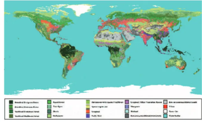
In 2008, the Global Map Global Version was released by the Working Group 4 of ISCGM as the main contributor (Fig. 1). These data were produced with remote sensing technology using satellite imagery and utilized for global environmental simulations and other purposes. Thereafter, Version 2 and Version 3 were produced in 2013 and 2016, respectively.
5. Utilization of Geospatial Information (2011-2015) The United Nations Committee of Experts on Global Geospatial Information Management (UN-GGIM) was established under the United Nations Economic and Social Council in July 2011. ISCGM had actively participated in the discussions from the time of its preparatory meetings and proposed a Global Map for Sustainable Development (GM4SD) based on its experiences in developing Global Maps in collaboration with NGIAs of participating countries. Also, the importance of global mapping was mentioned in the report of the United Nations Conference on Sustainable Development (Rio+20) held in June 2012.
In July 2013, Professor D. R. Fraser Taylor, who had served as the chair for more than ten years, stepped down and Dr. Paul Cheung, Professor at the National University of Singapore and ex-Director of the UN Statistics Division, assumed the chairpersonship. Under the leadership of Professor Cheung, ISCGM provided a forum for people from a wide range of fields to have frank and open discussions on the importance and usefulness of geospatial information, including the Global Map.
At the Third United Nations World Conference on Disaster Risk Reduction (WCDRR) held in Sendai, Japan
Photo 3 3rd Global Map Seminar in Dakar, 2008
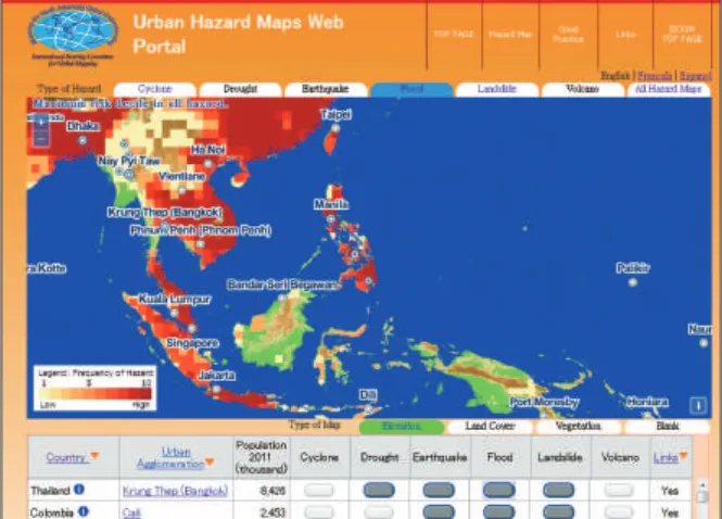
in March 2015, ISCGM explained at a session and a side-event symposium that effective utilization of geospatial information is crucial for enhancing the resilience of nations against natural disasters and shared its knowledge with the audiences. As a result, the “Sendai Framework for Disaster Risk Reduction 2015-2030” adopted at the plenary session emphasized the importance of utilizing geospatial information. Since WCDRR, ISCGM has further enhanced the existing Hazard Maps Web Portal (Fig. 2) by releasing hazard map information of many countries and good practices for hazard maps.
Also, ISCGM had been contributing to the field of disaster risk prevention by posting Global Maps of disaster areas (Fig. 3) to ReliefWeb (http://reliefweb. int/), which is operated by the United Nations Office for the Coordination of Humanitarian Affairs (UNOCHA) for enabling rapid decision-making and humanitarian response.
6. Toward Conclusion (2016-2017)
During the 20- year active period of ISCGM, the geospatial environment as well as the Project were changing little by little, as described in the following. a) At the time ISCGM was established in the
mid-1990s, digital cartography was not being widely used around the world. However, since then it has become commonplace.
b) With the growth of the Internet, various kinds of open geospatial information are now freely available and many people can use them easily.
c) In 2011, UNCE-GGIM was established under the United Nations Economic and Social Council to play a leading role in setting the agenda for the development of global geospatial information and to promote its use to address key global challenges. As a result, each NGIA was provided with another venue, other than ISCGM, to discuss various topics related to geospatial information.
d) As of February 2017, the number of participating countries and regions in the Project was 184. Also, the number of Global Map data-releasing countries and regions was 122 (representing about 2/3 of the earth’s land area).
e) ISCGM and relevant organizations carried out many capacity building programs and provided various tools for developing Global Map data for participating countries and regions. As a result of these activities, many developing countries were able to develop and release Global Map data.
In 2016, all members of ISCGM as well as the Project’s participating countries and regions could share their observations of environmental changes in geospatial information, recognizing that the objectives of the Project had been mostly achieved. Therefore, as the conclusion of the Project, the chair of ISCGM, Professor Cheung, proposed the termination of ISCGM and the transfer of Global Map data to the United Nations to make further contributions to the UN’s work.
Finally, the 23rd meeting of ISCGM was held in
August 2016. The resolution calling for the termination of ISCGM in March of the next year (2017) and the transfer of Global Map data to the United Nations was adopted.
Fig. 2 Hazard Maps Web Portal
Fig. 3 Global Map of a disaster area (April 2015 Nepal
Also, a signing ceremony for transferring Global Map data from ISCGM to the UN was held.
7. Results of the Global Mapping Project
Through various activities implemented by relevant organizations, Global Map data have been utilized in a wide variety of areas. The following are some typical examples.
a) IPCC (Intergovernmental Panel on Climate Change) In “IPCC Guidelines for National Greenhouse Gas Inventories” and “IPCC Good Practice Guidance for Land Use, Land-Use Change and Forestry”, Global Map data (GLCMNO) were introduced for international standard land-use data sets for calculating emissions and removal of greenhouse gases.
b) UNOCHA (the United Nations Office for the Coordination of Humanitarian Affairs)
Whenever a large-scale disaster happened anywhere in the world, the secretariat of ISCGM provided Global Maps of the disaster area to UNOCHA, as seen in Fig. 3. These Global Maps were released from ReliefWeb (http://reliefweb.int/) by UNOCHA to undertake on-site activities more effectively.
c) Textbooks
Global Map data global version has been used in several textbooks and supplemental teaching materials for geography curricula in secondary education in Japan. d) Data Downloads
Through the ISCGM website, Global Map data were provided to many users from Nov. 2000. A total of 53,329 users were registered and 275,412 downloads of Global Map data were recorded.
8. Summary
For over twenty years, ISCGM made a lot of progress in the Project and many results were achieved. For example, ISCGM and relevant organizations provided various seminars, workshops and training courses for capacity building. Through these and other activities, ISCGM worked to ensure that no one was left behind in the Project. As a result, a number of developing countries acquired knowledge of digital cartography and released
Global Map data.
The Project will be concluded and ISCGM will be terminated after the Global Map data transfer to the United Nations in March 2017. However, at the request of the United Nations, all of the Global Map data that were in existence as of December 2016 have already been released from the “Global Map data archives” (https:// globalmaps.github.io/) to maintain accessibility for general users.
The authors hope that the transferred Global Map data will be utilized in various projects of the United Nations. Also the authors would like to express their sincere thanks and appreciation to participating countries, participating regions and everyone involved with the Project for their sustained efforts and contributions to the Project.
References
ISCGM (2016): Global Mapping NewsLetter special Issue, July 2016, https://github.com/globalmaps/ news letters/blob/master/newsletter_special2016.pdf (accessed 7 Feb. 2017).
Hiromichi MARUYAMA (1998): History of Activities for Getting International Agreement on the Development of the Global Map, http://www.gsi. go.jp/ENGLISH/ page_e30131.html (accessed 7 Feb. 2017).
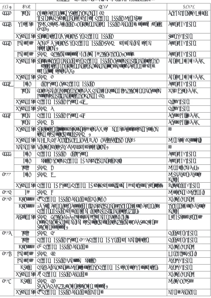
Year Month Event Venue 1992 June Earth Summit/Adoption of Agenda 21
Japanese Government advocated Global Mapping Concept. Rio de Janeiro, Brazil 1994 October JICA Group Training “Environmental Mapping Seminar” started (until
2012). Tsukuba, Japan
November International Workshop on Global Mapping Izumo, Japan
1996 February The 2nd Workshop on Global Mapping/ISCGM was decided to be
established. Tsukuba, Japan
February ISCGM1/Project started, chaired by Prof. John E. Estes Tsukuba, Japan November Inter–regional Seminar on Global Mapping for the Implementation of
Multinational Environmental Agreements/Executive Summary was submitted to the UN.
Santa Barbara, USA
November ISCGM2 Santa Barbara, USA
1997 March Mini Forum for Global Mapping Tsukuba, Japan
June 19th Special Session of the UN General Assembly/”Programme for the
Further Implementation of Agenda 21” New York, USA
November Global Mapping Forum ‘97 Gifu, Japan
November ISCGM3 Gifu, Japan
1998 June Global Mapping Forum ‘98 Sioux Falls, USA
June ISCGM4 Sioux Falls, USA
November Invitation letters were sent by the UN to Member States to encourage
them to participate in ISCGM. −
November ISCGM5/Adoption of Global Map Specifications (ver.1) Canberra, Australia
December Liaison with ISO/TC211was established. −
1999 March Global Mapping Mini-Forum Tsukuba, Japan
March Meeting of the Global Map Development in Asia Tsukuba, Japan
July ISCGM6 Cambridge, U.K.
2000 March ISCGM7 Cape Town, South
Africa
November Global Map Forum/Global Map ver.1 was released by various countries. Hiroshima, Japan
2001 May ISCGM8 Cartagena, Colombia
2002 August 1st Global Mapping Seminar in Nairobi Nairobi, Kenya
August “World Summit on Sustainable Development (Johannesburg Summit)”
Global mapping was included in the Implementation Plan. Johannesburg, South Africa September ISCGM9/Prof. D. R. Fraser Taylor became the chair.
EuroGeographics decided to participate in the Project. ESRI’s Grant programs started.
Budapest, Hungary
2003 July ISCGM10 Ginowan, Japan
July Global Mapping Forum 2003/Global Map Okinawa Declaration Ginowan, Japan
August 2nd Global Mapping Seminar Nairobi, Kenya
2004 February ISCGM11 Bangalore, India
February Global Mapping Lecture Meeting Tokyo, Japan
April Geo4 Side Event/ “Contribution of Global Map to Earth Observation” Tokyo, Japan
November 3rd Global Mapping Seminar Nairobi, Kenya
2005 April ISCGM12
INTERGRAPH’s grant program started. Cairo, Egypt
November 1st Global Mapping Seminar in Dakar Dakar, Senegal
Year Month Event Venue
2006 September Global Mapping Workshop Bangkok, Thailand
November ISCGM13 Santiago, Chile
December 2nd Global Mapping Seminar in Dakar Dakar, Senegal
2007 July ISCGM14 Cambridge, U.K.
2008 January 3rd Global Mapping Seminar in Dakar Dakar, Senegal
February Global Map Roundtable Conference
(ISCGM informal meeting) Port of Spain, Trinidad and Tobago
March Global Map Symposium Tokyo, Japan
March ISCGM15 Tokyo, Japan
June Global Mapping Forum 2008/Global Map Tokyo Declaration Tokyo, Japan June “Global Map Global Version ver.1” was released. −
2009 March Workshop on the application of Global Map Tokyo, Japan
June GSDI11/ ISCGM Informal Meeting Rotterdam, Holland
September International Workshop on the Revision of Specifications for Global Map
ver.2 Tsukuba, Japan
October ISCGM16/Global Map Specifications (ver.2) was adopted. Bangkok, Thailand
2010 October ISCGM17 Singapore
2011 May Global Map ver.2 was released by various countries. −
June ISCGM18 Winchester, U.K.
October 1st session of UNCE-GGIM and High Level Forum Seoul, Republic of
Korea 2012 June UN Conference on Sustainable Development (Rio+20)/importance of
global mapping was inserted in the official report. Rio+20 Side Event/Global Mapping Seminar
Rio de Janeiro, Brazil
August ISCGM19 New York, USA
August 2nd session of UNCE-GGIM/GM4SD WG was established. New York, USA
2013 February 2nd GGIM High Level Forum/Doha Declaration
GM4SD WG’s effort was presented. Doha, Dakar
July “Global Map Global Version ver.2” was released. − July ISCGM20/Professor Taylor stepped down as Chair and Professor Paul
Cheung became the new Chair. Cambridge, U.K.
July 3rd session of UNCE-GGIM Cambridge, U.K.
November Geospatial Information International Seminar Tokyo, Japan 2014 January 10th plenary session of GEO/Global Map continued to be registered as a
GEO task. Geneva, Switzerland
August ISCGM21 New York, USA
August Start of Hazard Maps Portal site and Catalogue Service. −
August 4th session of UNCE-GGIM New York, USA
2015 March WCDRR/”Sendai Framework for Disaster Risk Reduction 2015−2030” Sendai, Japan March Symposium on “Application of Geospatial Information Technology in
Urban Disaster Management” Sendai, Japan
August ISCGM22 New York, USA
August 5th session of UNCE-GGIM New York, USA
2016 August ISCGM23 (final meeting)/ceremony for Global Map data transfer New York, USA
August 6th session of UNCE-GGIM New York, USA