Struggle for the Kalahari and Its Resources
著者(英) Robert K. Hitchcock journal or
publication title
Senri Ethnological Studies
volume 70
page range 229‑256
year 2006‑12‑28
URL http://doi.org/10.15021/00002632
229
Edited by R. K. Hitchcock, K. Ikeya, M. Biesele and R. B. Lee
‘We Are the Owners of the Land’:
The San Struggle for the Kalahari and Its Resources
Robert K. Hitchcock
Michigan State University, USA
INTRODUCTION
The rights to land and natural resources for indigenous peoples are contentious issues in many areas of the world today. This is particularly true in those places where governments, multinational corporations, and individuals are expanding their operations and are competing with local peoples for access to land, wildlife, economically important plants, and minerals (Hitchcock 1997; Maybury-Lewis 1997). The process of globalization has seen the dispossession of substantial numbers of indigenous people, ranging from the tropical forests of Latin America to the savannas of Africa and from the tundra zones of the Arctic to the islands of the Pacific (Bodley 1999; Maybury-Lewis 2002; Nettheim, Meyers, and Craig 2002).
Today, another global process, the development of international laws recognizing indigenous rights, has the potential of redressing past injustices and ameliorating present circumstances (Anaya 1996; Niezen 2003). At the grassroots level, however, indigenous peoples continue to suffer losses of land and resources in spite of the efforts to promote their rights and well-being.
From the perspective of indigenous peoples today, colonization is an on-going process involving the imposition of external concepts of land tenure, law, governance, and sovereignty. One impact, perhaps the crucial one, was the drastic reduction of indigenous peoples land bases and their restriction to progressively smaller areas. In the United States, for example, Native Americans had surrendered 2 billion acres through treaties by 1887, leaving a residual 140 million acres.
Another 90 million acres was lost through the allotment policy which operated to
privatize Native American lands until 1934. As a result, today Native Americans
retain barely 5 percent of the United States (Sutton 1985; Wishart 1994). Similarly,
in New Zealand, through sales to the Crown and, after 1860, directly to settlers,
Maori retained only one third of the North Island and small, scattered reserves on
the South Island by 1892. A further 3 million acres passed out of Maori hands by
World War I, and this erosion of the land base continued through the 1960s. Maori
now retain only 5 percent of New Zealand (Durie and Orr 1993; Wishart 2001). At
least in the United States and New Zealand, the formal process of land sales was
observed. In Australia, no aboriginal title was recognized; instead, land was defined as
terra nullius (‘empty land’) and assumed to be without the impediment ofindigenous rights (Young 1995).
When their lands were lost, indigenous peoples also lost livelihoods, graves and other sacred sites, history — for history was written on the landscape — and much of their religions. Europeans and their colonial offshoots offered in return their form of civilization, based on Christianity, individualism, and private property ownership.
In virtually every area of the world where colonization took place, indigenous peoples were subjected to intensive pressures to assimilate which in many cases led, in effect, to their becoming invisible (Bodley 1999). In this way the Indian problem (as it was called in the United States) would be solved without a more overt stain of genocide. Indigenous peoples did not disappear, however, but rather have endured and in some cases prospered. Their identities, however, all too often were fractured by the pressure of assimilation efforts.
These identities have been fortified in recent years as indigenous peoples have re-asserted their rights to traditional homelands and challenged the assumptions and mechanisms that resulted in their dispossession (Niezen 2003). In doing so, they have extracted concessions from the still-colonizing powers that govern them. In Canada, for example, the
1982 Constitution Act formally recognized for the firsttime the inherent aboriginal rights of First Nations, paving the way for Supreme Court decisions which confirmed their original title to the land. And in Australia, since the June 3, 1992 High Court decision in Eddie Mabo and Others v. The State
of Queensland, which affirmed aboriginal title, Aborigines have the opportunity toprove their rights to ancestral lands and to be compensated for their losses (Mercer 1993; Hill 1995). With such legal breakthroughs came the opportunity to re- examine the historical record, but this time through the perspectives of the dispossessed. Such re-examination can result in regained identities and, sometimes, restored lands and resource rights.
The claims process has generally operated at the national level. Two forums in
particular stand out: (1) the Indian Claims Commission (ICC), which heard Native
American claims against the United States from 1946 to 1978, and (2) the Waitangi
Tribunal, which has received Maori claims since 1975. The Indian Claims Commis-
sion eventually made 274 awards, amounting to more than $818 million, but it
cannot be said that it redressed past injustices. The Indian Claims Commission was
created for a political purpose — to expedite termination, the policy to eliminate
Native Americans as separate factors in American society. Its composition (only one
Native American ever sat on the Commission), methods, and results prioritized
expediency rather than justice. The virtual absence of Native American participation,
the refusal to hold sessions on reservations, the rigid adversarial procedures, and the
prohibition of returning land all add up to a model that other nations investigating
indigenous claims should seek to avoid, unless all they want to do is to salve their
consciences (Sutton 1985; Wishart 1994). What is needed is a claims process that
combines international, national, regional, and local efforts and inputs and that
serves as a model that can be applied unambiguously to give indigenous peoples an opportunity to regain lost lands and resources, to safeguard their environments, to restore their identities, and to provide them the means to compete, on their own terms, in the modern world.
Latin American Indians have sought to register land and gain title over it (Maybury-Lewis 2002; Wali and Davis 1992). In order to do this, Indian communities and states go through adjudication, the process by which decisions are made about claims to land, that is, determining prior claims. This is similar to a kind of title search in contemporary real estate law. A problem is that the process of turning common property rights into federally recognized legal rights is often quite difficult.
The length of time it takes to survey the land, demarcate it, and to gain government recognition of indigenous rights over the land all present major problems to indigenous peoples. Even when the demarcation and titling is done, it can be overturned by a state or federal court, as was the case in Brazil, where land rights of Indians were called into question in 1996 with a decree signed by the President of Brazil (Presidential Decree 1775). This decree allowed farmers and ranchers to contest demarcations of indigenous peoples ancestral lands (Committee for Human Rights 1996). Fortunately for the Indians, the challenges were thrown out of court.
As it has turned out, however, the demarcations of Indian lands have had relatively limited impact because the Brazilian government has, by and large, not prevented land invasions.
In most cases, the governments of African and Asian nation-states do not have guarantees in their national constitutions for recognition of indigenous peoples’
lands (Bengwayan 2003; Hitchcock 2003; Hitchcock and Vinding 2004). One Asian country that does recognize indigenous land rights is the Philippines, whose 7.5 million ‘indigenous cultural communities’ (ICC) and ‘indigenous peoples’ (IP) have been granted rights to ‘ancestral domains’ (Fitschen 1998; Bengwayan 2003: 8). The
Indigenous Peoples’ Rights Act of 1997 of the Philippines (Section 33: Rights to Religious, Cultural Sites and Ceremonies) stipulates that indigenous peoples shallhave ‘the right to maintain, protect, and have access to their religious and cultural sites.” The problem in the Philippines, as in other Asian countries, is the degree to which the government enforces its own legislation.
Indigenous organizations, local leaders, and advocacy groups all maintain that it is necessary to gain not just de facto control over land and resources, but also de jure legal control. One way to do this is to negotiate binding agreements with states. A second strategy is to seek recognition of land and resource rights through the courts.
A third strategy is for indigenous peoples to obtain the funds necessary to purchase private land. In some cases, it is possible for indigenous peoples to rely on local- level rules about land and water allocation and to obtain rights through decentralized institutions such as district councils or provincial administrations. Finally, local level grassroots movements have sought rights over land and resources, and in a number of instances they have been successful, if at some cost.
In this paper, I address the various strategies that have been employed by the
San (Bushmen, Basarwa) of southern Africa in their efforts to obtain land and resource rights. I focus primarily on San in Botswana and, to a lesser extent, Namibia and South Africa. After a brief discussion of San patterns of dispossession, I address ways in which Kalahari San have sought to regain their land and resource rights.
SAN LAND AND RESOURCE RIGHTS ISSUES IN BOTSWANA
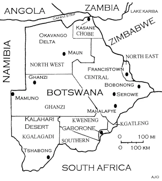
The Republic of Botswana is considered to be a model of successful economic development, democratic governance, and human rights (Stedman 1993) (Figure 1).
Figure 1 The study area
Botswana is Africa’s oldest parliamentary democracy, having had half a dozen successful elections since its independence in September, 1966. The government of Botswana does not recognize the San (who they term Basarwa) as indigenous people, arguing instead that all Batswana are citizens of the country (www.gov.bw/
basarwa/background.html). The San, on the other hand, do consider themselves to be indigenous peoples (Hitchcock 1996, 2002; Saugestad 2001). As one San put it,
“We are the first peoples. We are the owners of the land.” Another San pointed out, We have lived here in the Kalahari since time immemorial. We belong here, and the land is our mother.”
San peoples are found in virtually all of Botswana. Numbering between 48,000 and 50,000 (the Botswana government’s estimate is 60,000), San groups are found in all 10 of Botswana’s districts. Not all San are in rural areas; many of San live in the towns and cities of Botswana. San populations are heterogeneous. Many San live below the poverty line, some of them eking out an existence in remote parts of the country where resources that they depended upon heavily in the past are either not available in bulk, or they are not allowed to exploit them because they are on private land or in conservation zones. A major concern of San over the period of time since Botswana’s independence, therefore, has been to get their land and resource rights ensured (Hitchcock and Holm 1993; Hitchcock 2002).
In 1974, Botswana began what originally was termed a ‘Bushmen Development Program,’ later called the Remote Area Development Program, the aim of which was to promote development and provide education, health facilities, and training programs to enhance the well-being of people who lived mainly in rural areas. It must be noted, however, that San are also found in urban areas, including all of the district capitals and in the towns and cities of the country. The Remote Area Development Program currently operates in 7 districts in Botswana (Central, Chobe, Ghanzi, Kgalagadi, Kgatleng, Kweneng, and North West (Ngamiland).
Over time, substantial numbers of San in Botswana were dispossessed through (1) the establishment of freehold farms, covering some 5% of the country, (2) the declaration of national parks, game reserves, and other state lands, which together make up 17% of the country, and (3) the usurpation of land and water points by other groups in the communal (tribal) areas, which together make up 71% of the country. Some San resided on cattle posts and agricultural lands belonging to other groups. This was the case, for example, in the western Central District, where San were found on nearly all of the cattle posts and ranches (Hitchcock 1978, 1980;
Campbell and Main 1991). In Ghanzi District, a large district that at one time was part of what was called Crown Land, much of the land was set aside as freehold farms. San lived on the farms essentially as squatters as they did not have rights to remain there except at the behest of the farm owner.
In the 1970s, the Remote Area Development Program initiated an effort to
establish four ‘land and water schemes’ in areas outside of the Ghanzi Farms on
communal land in the district (Wily 1979). Three of these schemes eventually were
developed: West Hanahai, East Hanahai, and Groot Laagte; the fourth, at Rooibrak
in the northern part of the district, never got off the ground because of the failure to find water. The problem for the San who moved to these places, however, was that they did not have exclusive rights there. Other people came in, some of them with the livestock. In some cases, there were serious land use conflicts, but the San had no option but to accept the situation.
There were literally thousands of people already living on the cattle posts in the grazing areas, many of them San (Hitchcock 1978, 1980; Wily 1979). In order to try and ensure that large numbers of people were not dispossessed, efforts were made to carry out a land adjudication effort in which customary rights to land were supposed to be recognized. There were also efforts to get the Attorney General’s Chambers to recognize hunting and gathering rights of San and other peoples. A serious challenge to land rights came from the litigation consultant to the Attorney General’s Chambers, who noted,
As far as I have been able to ascertain, the Masarwa have always been true nomads, owing no allegiance to any Chief or tribe, but have ranged far and wide for a very long time over large areas of the Kalahari in which they have always had unlimited hunting rights, which they even today enjoy in spite of the Fauna Conservation Act. The right of Masarwa to hunt is, of course, very important and valuable as hunting is their main source of sustenance. . . Without much clearer information, it is impossible to give a confirmed opinion about the Masarwa. Tentatively, however, it appears to me that (a) the true nomad Masarwa can have no rights of any kind except rights to hunting (“Opinion in Re: Common Leases of Tribal Land,” Ministry of Local Government and Lands file 2/1/2, 1978).
In other words, the government’s main legal body had decided that the San could be denied land rights but allowed hunting rights simply on the basis of ethnic affiliation. Some of the San who heard about this ruling said that they were deeply disturbed by the fact that Botswana, a state that prided itself on being democratic and multiracial, had taken a position that was reminiscent of the apartheid (separate development) policies of neighboring South Africa.
The Botswana government was quick to disavow the position of the Litigation
Consultant. A number of government officials stressed that Botswana was a country
which by law did not discriminate against anyone. The Minister of what was then
the Ministry of Local Government and Lands went so far as to state that “Any land
board using the ethnicity of San as a reason to accept or reject an application would
be dealt with severely” (Wily 1979: 125). The problem, however, was that the
central government ministry generally refused to overturn district-level land board
decisions. In most cases, land boards did not grant blocks of land to San
communities, preferring instead to allocate only arable plots of a few hundred square
meters at most to individuals.
THE TRIBAL GRAZING LAND POLICY AND SAN
The shift from communal to individualized systems of land tenure is a process that has occurred throughout the developing world. During the 20th century there were at least 25 major attempts to reform the basis of land tenure in various countries, some of them relatively successful, others markedly unsuccessful. The underlying reasons for launching a land reform effort in Botswana were spelled out in detail in a Government of Botswana White Paper published in 1975 (Republic of Botswana 1975). According to this document, the aims of the land policy were threefold: (1) to stop overgrazing and degradation of the range; (2) to promote greater equality of incomes in rural areas, and (3) to allow growth and commercialization of the livestock industry on a sustained basis. The best way to achieve these aims, it was argued, was through the granting of exclusive rights to individuals and groups who would then have an incentive to manage their grazing in appropriate ways.
In order to achieve the objectives of aims of conservation, production, and equity, it was suggested that the grazing land in Botswana be divided into three zones: commercial, communal, and reserved. In the commercial areas leasehold rights would be granted over blocks of rangeland; in the communal areas the basis of land tenure would remain the same as it was before; and land would be set aside as reserved “for the future” (Republic of Botswana (1975: 6‑7). Large-scale cattle owners would be encouraged to move to the commercial areas, where they could establish fenced ranches in exchange for a rental payment to the district Land Board.
Grazing pressure in the communal areas would be relived, thus enhancing herd productivity and at the same time providing a more equitable distribution of land for rural people.
Special attention was paid in the White Paper to protecting “the interests of those who own only a few cattle or none at all” (Republic of Botswana 1975: 6).
The TGLP White Paper also states that “Planning will aim to ensure that land development helps the poor and does not make them worse off” (Republic of Botswana 1975: 2). In addition, the policy underscores the basic principle of the traditional land tenure system in Botswana, which is “the right of every tribesman to have as much land as he needs to sustain him and his family” (Republic of Botswana 1975: 4). The preservation of land rights, therefore, was considered a key aspect of the policy.
The implementation of the Tribal Grazing Land Policy since 1975 saw a
number of shifts from the original policy as outlined in the White Paper. As the
program evolved, it was found that there was not as much “empty” land into which
large cattle owners could move as was envisioned originally. Decisions by Cabinet
and Attorney General’s Chambers changed some of the basic tenets of the policy,
such as the amount of rent to be charged to leaseholders (it was set at a sub-
economic rate of 4 thebe per hectare). The idea of stock limitations on commercial
ranches was dropped, and there were no requirements for leaseholders other than
constructing firebreaks around their property and managing the range “in accordance with the principles of good husbandry” (TGLP lease document).
In the period between 1975 and 1979, a series of zoning and land use surveys in rural Botswana resulted in the formulation of a series of land use plans in which the various zones were designated. These surveys revealed the presence of large numbers of residents in potential commercial areas, many of whom did not have water rights there but who used the land for foraging, grazing, arable, and residential purposes. These surveys also found that there were a fairly large number of wells and boreholes in the areas, meaning that some people had de facto rights to some of the grazing land already.
When it was found by district development officers and researchers that many of the sandveld areas had existing water points and people in them, land use planners responded by zoning the land either commercial or communal. No land was zoned as reserved because it was felt that there was insufficient land for communal use already. Thus, in spite of the fact that the “reserved areas” were the only “safeguards for the poorer members of the population” (Republic of Botswana 1975: 7), it was decided to forego zoning land in this way. Instead, some of the land was left unzoned pending further investigation.
In 1975, when the government of Botswana launched the Tribal Grazing Land Policy, it was maintained that that main purposes of the program were to promote the interests of small-scale livestock producers and to conserve grazing. As the program evolved, however, commercial ranches for large-scale producers became the major focus. The idea behind the TGLP was that people with livestock in the overgrazed communal areas would be allowed to move into the undeveloped areas with their animals where they would be able to obtain leasehold rights over blocks of land. These blocks of land, which averaged 6,400 hectares (8 by 8 km or 5 by 5 miles), were supposed to be developed through a combination of water provision (borehole drilling), fencing, and other kinds of infrastructure such as trek routes.
From the mid to late 1970s on, the Remote Area Development Program, district officials, researchers, and non-government organizations sought to get the land and resource rights of San recognized. One way this was done was to plan for what were termed ‘hunting and gathering areas,’ large blocks of land where people would be able to continue their foraging activities. This concept, however, was thrown out by the Land Development Committee which oversaw the land use planning process associated with the Tribal Grazing Land Policy.
The Remote Area Development Program attempted to ensure that people in areas zoned commercial were not deprived of access to land when ranches were established. Several strategies were employed to see to it that the needs of remote area populations were met. These strategies can be divided into several categories:
( l ) the carrying out of careful population surveys and consultation efforts, (2) the
implementation of adjudication procedures, (3) the setting aside of land for people
within commercial areas, (4) dezoning areas where there were land use conflicts, (5)
adding appendices to the TGLP lease, and (6) promoting diversified development
activities in communal and Wildlife Management Areas.
In some cases, district Land Boards drew up appendices to the lease to be given to ranchers. This was done by the Ngwato (Central District) Land Board, for example. In this case, the appendices spelled out in detail the rights of ranch residents. These activities included the rights of people to continue to (a) hunt, (b) gather, (c) graze livestock, (d) cultivate fields, and (e) send their children to school.
Unfortunately, the Attorney General struck down these appendices as “illegal” and ordered the Land Boards to drop the idea. What this decision meant, in essence, was that the ranch lessees were to be given full rights to the land, and anyone caught trespassing would be liable to removal and criminal prosecution.
At the time the Tribal Grazing Land Policy was declared, it was felt that the granting of exclusive rights would necessarily lead to greater efforts at conservation.
What actually happened, however, was that in a sizable number of cases, ranches were stocked heavily, and the grazing was reduced significantly. This problem was exacerbated by the erection of border fences. In the past, people whose land was too heavily stocked or whose grazing was destroyed by bush fires were able to move their herds to new areas. With population increase and new fenced ranches having been established, this was no longer as possible as it was previously. The consequence has been that some of the ranches have become badly overgrazed. In several cases, the situation became so severe that people removed their herds and abandoned the ranches completely, taking their animals back to the communal areas.
As the zoning process evolved, it was noted that some of the land had substantial numbers of wildlife, especially antelope. In 1978‑79 the Countrywide Wildlife and Range Assessment Project (CWARAP) conducted aerial and ground surveys that indicated that there were sizable herds of wildlife in some rural areas.
Since only a portion of those areas where wildlife was found was protected as national parks and game reserves, it was recommended that a new land zoning category be created: Wildlife Management Areas, places where people could take part in hunting (provided that they had licenses) and other natural resource related activities such as tourism. Eventually, 21% of the country was zoned as Wildlife Management Areas. It is important to note that virtually no land whatsoever was set aside as reserved; thus, the “safeguards for the poor” were dispensed with completely.
The question of social equity is still a contentious issue. Over 20,000 people reside in the commercial ranching areas. Some of these people were required to leave the ranches, and compensation, when it was given, was in the form of cash.
The argument that compensation be provided in the form of land was accepted only to a limited degree. When there were conflicting rights over commercial ranches, the Land Boards opted for dezoning (declaring the area communal). The alternative strategy was to set aside blocks of land either within or adjacent to commercial ranching areas where people who are required to leave leased land could gain access to social services and some land for production purposes.
The strategy proposed by the Remote Area Development Program and
researchers working with it was that blocks of land be set aside within the commercial zones as communal service centers (CSCs). The way it worked out, only small areas of land were set aside for this purpose by district administrations.
In the case of the Hainaveld in North West District, for example, a small portion of a single ranch was established as a service center. This center was much too small to provide for the land needs of the hundreds of people who were told to leave the commercial ranches.
By the mid-1980s only 1,058 square kilometers of land had been set aside in the TGLP commercial areas for use by local people. Populations in some of these service centers were often quite high. As a result, the resources in these areas were utilized intensively, bringing about localized environmental degradation and greater expenditures of effort to obtain crucial resources such as firewood, thatching grass, and edible wild plant foods. The service centers became, in effect, residual relocation places for people who formerly had lived in small communities scattered throughout the grazing areas of Botswana.
From the time of its inception in the mid-1970s, the Remote Area Development Program focused much of its attention on the establishment of settlements for San and other people living in remote areas. These settlements consisted of water points, schools, health posts, and, in some cases, kgotlas (community meeting places where public policy issues were discussed). By the mid-1990s, there were some 63 settlements that had been established either through the Remote Area Development Program or through District Council efforts, many of them in the Kalahari (Chr.
Michelsen Institute 1996). The infrastructure for these settlements was paid for either by the District Councils or out of a central government budget for remote area development (LG 32).
In the late 1980s, the Norwegian Agency for Development Cooperation (NORAD) began providing funding and technical assistance for what was called the Accelerated Remote Area Development Program (ARADP) (see Chr. Michelsen Institute 1996; Saugestad, this volume). The ARADP, which lasted from 1988‑1996, had a number of impacts, not least of which was the provision of physical and social infrastructure in remote areas, with water points, schools, health posts, and teachers’
quarters being built.
In the early 1990s, it was proposed that there should be 3 so-called Remote
Area Dwellers (RAD) ranches established in Ghanzi District, one near Groot Laagte,
a second near West Hanahai, and a third at Chobokowane. Because some well-
placed individuals in the government had sought rights over those ranches, the
government decided to withdraw them, much to the chagrin not only of San and
other people living in those communities but also the non-government organizations
supporting them. It was this event, combined with the concern over the potential
removals of people from the Central Kalahari Game Reserve, which had first been
proposed formally by the Botswana Government in 1985‑86, that the San and other
minority groups in Botswana began to intensify their efforts to seek land and
resource rights (Chr. Michelson Institute 1996; Saugestad 2001; Hitchcock 2002).
By the end of the millennium, San had relatively little land left in Botswana.
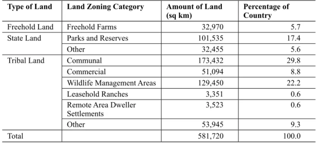
The only areas set aside for San were the Remote Area Dweller settlements, which, by the end of the millennium, covered a total of 3,523 sq km, or 0.6% of the country (see Table 1).
The only other area where San had been granted rights, at least theoretically, was in the Central Kalahari Game Reserve, the largest game reserve in Botswana and the second largest reserve in Africa. When the reserve was created in 1961, it was aimed at meeting the needs of San hunter-gatherers and conserving wildlife and habitats (George Silberbauer, personal communication, 1978). In the 1980s, it was decided by the Botswana government that the people of the Central Kalahari should be relocated to settlements where they could receive, as one government minister put it, ‘the benefits of development.’ The rest of the land in the country was freehold land (5.7%), state land (23%), or tribal land (70.7%, not including the remote area settlements). None of the areas, including the RAD settlements and the Central Kalahari Game Reserve, were occupied exclusively by San, nor did San have the rights to prevent other people from entering these places.
SAN EFFORTS TO SEEK LAND AND RESOURCE RIGHTS
The primary way that San and other people got access to land and water in the past in rural Botswana was through self-allocation, that is, through moving into an area, establishing occupancy, and, in so doing, gaining use rights. Over time, these rights became, in effect, customary rights. San also attempted to ensure their occupancy rights in some cases by approaching traditional authorities (e.g. Tswana chiefs, headmen, and headwomen) to ask them for the right to live in specific areas.
Table 1 Land zoning categories in Botswana’
Type of Land Land Zoning Category Amount of Land
(sq km) Percentage of
Country
Freehold Land Freehold Farms 32,970 5.7
State Land Parks and Reserves 101,535 17.4
Other 32,455 5.6
Tribal Land Communal 173,432 29.8
Commercial 51,094 8.8
Wildlife Management Areas 129,450 22.2
Leasehold Ranches 3,351 0.6
Remote Area Dweller
Settlements 3,523 0.6
Other 53,945 9.3
Total 581,720 100.0
Note: Data obtained from the Ministry of Local Government and the Ministry of Lands and Housing, Government of Botswana
In many cases, the traditional authorities granted these requests, at least verbally, if for no other reason than the fact that they felt that the presence of local people in remote areas would have some benefits. As one Tswana traditional authority put it to me in August, 1976, “We could always go out hunting and ask the Basarwa to help us. They were excellent trackers and were very useful when it came to butchering the animals we killed and making biltong (dried meat).” Tswana and Kalanga living in the Nata River region on the border of Zimbabwe felt that the presence of San would help dissuade people from coming across the border from neighboring Zimbabwe and engaging in hunting, grazing domestic animals, or engaging in other kinds of activities such as collecting salt at the base of the Nata River in Sua Pan.
After the passage of the Tribal Land Act in Botswana, which went into effect in 1970, local people had to apply to the district land board for water and grazing rights. If there was a sub-land board in the area, it was that body to which they had to apply for arable rights (plots of agricultural land), residential rights (for their homes), and business plots (places where individuals could run an enterprise). It should be noted that San had enormous difficulty in getting land boards to agree to granting them water rights and grazing rights. Under Tswana customary law, individuals could establish a water right if they invested labor and capital in the digging of a well or the drilling of a borehole (Schapera 1943). Very few, if any, San had the capital to expend in the digging of a well or especially the drilling of a borehole, which, in some cases, cost upwards of P100,000 or more.
Even in those cases where well-digging was carried out for San communities by well-meaning individuals and organizations, as occurred in the mid-1970s in Ngamiland, the Tawana Land Board refused to grant water rights to the local communities. There were even cases, as at Shaikarawe in northern Ngamiland, where the Tawana Land Board opted to give water rights to an individual who came in to the area after a well had already been established by San. Fortunately, in this case, the land board decision was eventually overturned, thanks to the intervention of a San support organization, Kuru Development Trust (now, part of the Kuru Family of Organizations, KFO) and Ditshwanelo, the Botswana Center for Human Rights. The Bugakwe San were able to return to the water point that they had dug originally and to reside in the area, graze their animals, and carry out agricultural and foraging activities.
In the 1970s, 1980s, and 1990s, San communities applied to land boards for blocks of land where they could carry out diversified economic activities. However, there were no cases where San communities were granted land rights or grazing rights. San in Ngamiland began digging wells in the hopes of getting a water right under Tswana customary law. As it worked out, even when water points were established with local labor, the land boards refused to grant water rights to San communities and individuals
San began to seek alternative means to obtain land and resource rights. In some
cases, they entered into informal partnerships with non-San individuals who then
would apply for land and water rights. Such a strategy was employed by a group of Tyua San, for example, in northern Central District. In other cases, San communities sought outside assistance, as occurred in western Ngamiland, where San communities requested funds for water prospecting and borehole drilling. What they hoped would happen was that the Land Board eventually would see the utility of granting water rights and, by extension, land rights.
In some areas, as in the case of the Dobe area (NG 3) and the Ncwaagom (NG 10 and 11) areas in Ngamiland, community mapping efforts were undertaken with the assistance of a consultant and local people. These mapping activities, which involved the use of Geographic Positioning Systems (GPS) equipment, enabled local groups to participate extensively in the identification and demarcation of their traditional areas. Among the Ju’hoansi of western Ngamiland, for example, ancestral territories are known as
n!oresi (sing. n!ore). Among the Ju’hoansi, an!ore is a named place containing various natural resources to which people have rights. Members of other Ju’hoansi groups can seek permission to enter another group’s n!ore and utilize the resources there; in order to do so, they must approach the n!ore kxau, a kind of land and resource manager who has lived for a long time in an area. In the case of
XaiXai, there are three n!oresi centering on the waterpoint. There is also a n!ore at Gwihaba which is now a national monument. In the Dobe area, to the north of XaiXai, there are 8 n!oresi ranging in size from 40 sq km (!≠Arinao) to 244 sq km (Ghii≠ahn) (Arthur Albertson, personal communica- tion, 1998). Ju’hoansi at Dobe have requested water rights from the North West District Council and the Tawana Land Board. With assistance from the Trust for Okavango Development Initiatives and some funding from the Kalahari Peoples Fund, several boreholes were drilled in the Dobe area. A number of Ju’hoansi were in the process of moving away from Dobe and re-establishing themselves in their traditional n!oresi in 2004‑2005.
The mapping and land use documentation work in western Ngamiland has
shown that the traditional land use system still influences contemporary land use
patterns.
N!ore kxausi are still recognized, although the degree of their authoritymay have lessened somewhat over time as land allocation rules were formalized and
placed in the hands of land boards. Ju’hoansi and other San have been very astute
in their dealings with local authorities and with land boards, making sure that they
keep everyone informed of their desires for land and resources and coming up with
land use and management plans when asked to do so. The San have sought the
assistance of non-government organizations in an effort to enhance their capacity to
manage land and resources and to help generate income and employment opportuni-
ties. Local level training on land and resource rights were undertaken by NGOs
including WIMSA, Kuru, TOCaDI, and Ditshwanelo (the Botswana Center for
Human Rights). Materials have been produced that local people can refer to as they
seek to promote their land rights (see, for example, Ditshwanelo 1998). In addition,
representatives of a number of San communities attended district-level and national
meetings on land, development, human rights, and community based natural
resource management where they attempted to raise awareness of the needs of San for more secure rights to land and resources.
In Ghanzi District, Botswana, Nharo San from the community of D’Kar worked out an agreement with Kuru Development Trust and SNV, the Netherlands Development Organization, to purchase a freehold farm at Dqae Qare, 11 km north of Ghanzi Township. This farm today is run by the D’Kar Community Trust and generates income for the employees of the farm and for the community. It should be stressed, however, that Dqae Qare is unusual in Botswana since it is the only freehold land currently owned by a San community. Other San groups in Botswana discussed the idea of seeking access to freehold land or to leasehold ranches, but it was decided that the process was too difficult or costly.
COMMUNITY BASED NATURAL RESOURCE MANAGEMENT AS A RESOURCE ACQUISITION STRATEGY
The San of Botswana realized that if they were to gain greater control over their areas, they were going to have to employ some new strategies. A suggestion made by a number of San and groups working with them was that they use the community-based natural resource management program of Botswana as a means of gaining greater control over land and wildlife resources.
Botswana’s community based natural resource management (CBNRM) program was endorsed officially with the approval of the
Wildlife Conservation Policy of 1986, but it was implicit in the Tribal Grazing Land Policy of 1975. Theright to decentralize wildlife management was legislated in 1992 with the passage of the
Wildlife Conservation and National Parks Act of 1992. The challenge facingBotswana over the next two decades was to come up with workable methods for implementing the Wildlife Conservation Policy and the National Parks Act and the regulations associated with it.
The current wildlife policy of Botswana empowers the Department of Wildlife and National Parks in the Ministry of Environment, Wildlife, and Tourism (MEWT) to work out arrangements with local communities and district authorities on how the wildlife resources within their areas will be handled. Under Botswana legislation, local communities can not only apply for a wildlife quota, they can also lease out some or all of the animals on the quota to private safari operators. Alternatively, they can keep the quota for themselves and use it for subsistence purposes or not use it at all, making the choice instead to conserve it for the future.
In 1989, a regional Natural Resources Management Program was proposed by
the U.S. Agency for International Development. In 1990, the Botswana Natural
Resources Management Program began, with the government of Botswana
collaborating with USAID. The Department of Wildlife and National Parks hosted a
team of development workers who assisted the DWNP and District Councils to carry
out community-based natural resource management activities. One of the first places
where CBNRM activities were initiated was in the Chobe Enclave of Chobe District
in northern Botswana. Smaller-scale CBNRM activities took place in other areas, including Sankuyo in the Okavango Delta region.
In the early 1990s, SNV, the Netherlands Development Organization began working on CBNRM in two areas of Botswana,
XaiXai (Cgae Cgae) inNgamiland and Ukhwi in Kgalagadi District. In these two communities, efforts were made to establish community trusts, local-level organizations that had formal structures, a constitution, an executive body, and a management plan. One of the first formal community trusts established in Botswana was at
XaiXai (CgaeCgae).
XaiXai is a multiethnic community of some 400 people consisting ofJu’hoansi San and Mbanderu (Herero). The Trust has entered into a lease agreement with a safari operator, and in exchange they get royalty payments, employment opportunities, and medical supplies. The XaiXai community elected to set aside a portion of the quota for subsistence hunting purposes. Some funds were generated by local people, the majority of them Ju’hoansi San, through the manufacture and sale of handicrafts.
A second trust in which San represent the majority of the members is the Nqwaa Khobee Xeya Trust, which was established on June 10, 1998 in western Kgalagadi District. This trust includes members from three communities: Ukhwi, Ncaang, and Ngwatle. The trust is located in one of the Wildlife Management Areas of Kgalagadi District, KD 1, which is 12,255 sq km in size. The population, which is approximately 800 people, consists of !Xo San, Bakgalagadi, and Balala. Some of the activities in the area include ecotourism, safari hunting, craft production and sale. The Nqwaa Khobee Xeya Trust has a lease agreement with a safari operator and, as in the case of
XaiXai, the members of the trust engage in subsistencehunting if they so choose. In 2001, the safari operator paid P100.000 in rental and P50,000 in quota fees. In addition, P30,000 were placed in the social development fund, and an estimated P5,000 were earned from craft sales.
The trusts have different operating procedures, and this led to some uncertainty on occasion for the memberships of those trusts. One problem was that the community members do not always agree about the ways to handle issues. In the case of the Nqwaa Khobee Xeya Trust, for example, the distribution of benefits is done by household groups, which is advantageous when compared to
XaiXai,which sometimes has seen marked disagreements between Ju’hoansi and Mbanderu over benefit distribution. There were also questions that arose over the handling of funds by some of the community trusts.
In 2000, a formal decision was made by the Ministry of Local Government that
the community trusts involved in CBNRM would no longer have the right to make
their own decisions on natural resources or to retain their own funds generated from
those resources, the benefits of the resources instead being, as one government
official put it, a national resource, like diamonds. The decision affected the 60 or so
community-based natural resource management projects that existed at that time in
the Wildlife Management Areas and communal areas in Botswana. This decision,
which has yet to be rescinded formally by the government of Botswana, had effects
on the viability of community trusts throughout the country.
Several reasons were given for this decision. One was that central government and the district councils saw the sizable economic returns going to communities and wanted to capture some of those returns for themselves. Another reason, suggested by a high government official, was that San, who represented the majority of the trust members in some areas (e.g.
XaiXai, Mababe, Khwaai, the OkavangoPanhandle, and Ukhwi), ‘did not know how to manage their own organizations and funds’ and therefore, he argued, the government had to step in. A third reason given was that the CBNRM program could potentially result in user rights being transformed into ownership rights, something that government officials were concerned about.
The San and other groups saw the utility of the CBNRM program as a means of gaining greater control over land and resources. While it was understood that the CBNRM-related legislation was limited to wildlife resources, there was a sense that the establishment of community trusts could help secure greater access to land and economically valuable plant resources as well. In spite of the constraints posed by the uncertainty relating to the Botswana Governments decisions on community trusts and their operation, the numbers of local communities in Botswana that were interested in becoming involved in community-based natural resource management and utilization is on the up-swing. As of 2005, there were over a hundred communities that were engaged in organizing themselves as representative and accountable management groups and were attempting to get themselves registered officially with the government of Botswana as legal entities.
DIRECT ACTION IN AN EFFORT TO PROMOTE LAND AND RESOURCE RIGHTS
By and large, San in Botswana have not resorted to direct action — demonstrations and strikes — in an effort to bring attention to the need for land and resource rights. In Namibia, on the other hand, there have been some demonstrations, some of which have resulted in confrontations between San and the state. Such a demonstration occurred in October, 1997, for example, when a group of Haiom San blocked an entrance into the Etosha National Park. Seventy three Haiom were arrested and detained, but the charges of unlawful assembly and trespassing eventually were dropped. The demonstration and events surrounding it served to bring worldwide attention to the Haiom claims for recognition of their land and resource rights.
The history of Namibia differs from that of Botswana in that the dispossession
of San came about in part through deliberate government policy. A larger portion of
the country was set aside as freehold land, for use by white commercial farmers, by
the South West African Administration and, before that, by the Germans. As Werner
(1991: 45) points out, ‘Land alienation by Europeans began in 1883 when a German
trader, Adolf Luderitz, obtained the first tracts of land from chief Joseph Fredericks
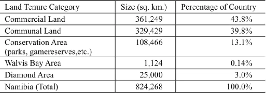
in the south of the territory.’ Colonial officials in Namibia obtained access to land in similar ways as did Euroamericans in North America: by signing treaties with local group leaders. The privatization of land that occurred in Namibia saw the establishment of rigid land boundaries and fences. People who lived on the land were required either to become laborers on the farms of other groups, or they had to move to the towns or the crowded communal areas (for a summary of land use categories in Namibia, see Table 2). There were relocations of people out of areas that were deemed suitable for white farming, many of them into more crowded communal (‘native reserve’) areas.
Forced removals of people of people from commercial areas occurred throughout the period of South African occupation, from 1919 until the late 1980s.
In 1962, the government of South Africa appointed a Commission of Enquiry into South West African Affairs, sometimes referred to as the Odendaal Commission.
The ‘native reserves’ in Namibia were consolidated into ethnic homelands, one of which was ‘Bushmanland’ in the northeastern part of the country. It should be noted, however, that the establishment of the ‘Bushman Reserve’ actually predated the Odendaal Commission, going back to a ‘Commission for the Preservation of the Bushmen’ appointed in 1949 on which P.J. Schoeman, an Afrikaans writer, sat. A final report of this commission, submitted to the government in 1953, had only one reserve for San, that of Bushmanland (LeRoux and White 2004: 110‑116). Whereas San had lived throughout Namibia on their own land, the late 19
thand 20
thcentury period saw widespread dispossession. By the 1970s, the only San group in Namibia that remained on a portion of its own land was the Ju’hoansi of the Nyae Nyae region.
Some San in Namibia resisted the efforts to remove them from their ancestral territories and deny them basic rights. They did so in a number of ways — from taking up arms against the government in some cases to engaging in sit-down strikes on freehold farms. In the 1980s Ju’hoan leaders had confrontations with government officials, for example, over the drilling of boreholes in Nyae Nyae by the then Ministry of Wildlife Conservation and Tourism (now, the Ministry of Envi- ronment and Tourism, MET). Ju’hoan leaders took part in the post-independence National Conference on Land Reform and the Land Question in June-July, 1991,
Table 2 Land tenure situation in Namibia
Land Tenure Category Size (sq. km.) Percentage of Country
Commercial Land 361,249 43.8%
Communal Land 329,429 39.8%
Conservation Area
(parks, gamereserves,etc.) 108,466 13.1%
Walvis Bay Area 1,124 0.14%
Diamond Area 25,000 3.0%
Namibia (Total) 824,268 100.0%
where they presented to a rapt audience a map of their traditional territories in the Nyae Nyae region. Subsequently, the Ju’hoansi approached government ministers and the President of the new nation of Namibia, Sam Nujoma, when Herero pastoralists brought their herds into the Nyae Nyae region uninvited. The president of Namibia intervened, and the Herero were escorted peacefully out of Nyae Nyae.
In the period from 1992‑2002, the Ju’hoansi of Nyae Nyae worked hard to consolidate their control over the Nyae Nyae region. Not only did they continue to take part in national discussions on land and development, they also took part in programs with donor agencies and the government of Namibia aimed at promoting community based natural resource management. The Ju’hoansi were able to benefit from a project funded by the U.S. Agency for International Development (USAID) called the Living in a Finite Environment (LIFE) program.
In 1996, the Government of Namibia passed legislation that modified the
Nature Conservation Ordinance of 1996,allowing for the establishing of conservancies in communal areas of the country. In Namibia, conservancies are locally planned and managed multipurpose areas that can be granted wildlife resource rights. One of the earliest conservancies in Namibia was that of Nyae Nyae, which was established in July, 1998. The Nyae Nyae Conservancy (NNC) had a council which oversaw resource management and development activities.
Some of the revenues for the conservancy came from a joint venture with a safari operator who paid royalties to the NNC. Other funds were generated through local- level tourism activities and craft production. By the early part of 2005, the Nyae Nyae Conservancy was made of up 36 communities spread across an area of 9,003 sq. km.
In 2002, the Nyae Nyae Conservancy generated N$956,500. Of this amount N$477,672 was distributed as benefits to the 770 adult members of the conservancy, N$620 per person (U.S. $1 = N$7.5). The safari operator that had the concession in the Nyae Nyae Conservancy, African Hunting, employed 26 men and 2 women. A side benefit of the safari hunting in the Nyae Nyae area was the meat that came from the animals killed by the safari operators’ clients. Some Ju’hoansi noted that the meat represented an important contribution that helped fill some of the protein needs of their households. Approximately 16% of the income earned by residents of the Nyae Nyae area in 2002‑2003 came from craft sales (Polly Wiessner, personal communication, 2003). In 2004‑2005, the Nyae Nyae Conservancy was considering going into a joint venture agreement with a tourism company to establish a lodge in the area, something that the NNC executive committee felt would help generate income and employment for Ju’hoansi.
In July, 2003, the San in the neighboring area of what used to be called West
Bushmanland, now called Tsumkwe District West, were able to establish another
conservancy, Na Jaqna, which was nearly identical in size as the Nyae Nyae
Conservancy, covering an area of 9,120 sq km. Prior to the time the Na Jaqna
Conservancy was established, the !Kung and other San in the area faced the prospect
of some of their land being taken over by the government or Namibia for purposes
of establishing a large refugee camp. As it turned out, the end of the war in Angola in 2002 precluded the need for such a refugee camp, and the people of Tsumkwe West were able to get their conservancy gazetted.
Both the Nyae Nyae Conservancy and the Na Jaqna Conservancy councils were facing some challenges in 2005. Pressures were building to expand incomes for conservancy members. There was the ever-present threat of outsiders wanting to bring livestock into the conservancies to take advantage of the availability of water and grazing. There were some internal disagreements over how best to handle issues such as tourism and wildlife management. In Nyae Nyae, Ju’hoansi were worried about the impacts of elephants on their water points and were endeavoring to protect their water sources through the construction of water protection facilities consisting of walls of rocks and cement. As one Ju’hoansi put it, ‘We have our land and waters, but now we have to protect them from both people and animals.’
The situation for the San in Namibia is complex, given that a sizable proportion of the San population is residing in commercial farming areas (e.g. on the Gobabis and Grootfontein Farms) or in insecure tenure situations in communal areas. The gazettement of national parks and game reserves in areas that used to belong to San (e.g. West Caprivi, now part of Bwabwata National Park and Etosha National Park) has meant that San groups such as the Khwe and the Haiom land and resource rights have been compromised. As a result, some San have resorted to direct action, as was the case with the Haiom at Etosha in 1997, while others have pursued alternative strategies such as seeking help from NGOs to establish conservancies or, in some cases, to assist in the purchase of freehold land (for a list of some of the conservancies and community trusts that have significant percentages of San in their areas, see Table 3). Although conservancies and community trusts do not ensure legal rights to land, there is no question that the San feel that establishing these kinds of institutions will help bring about greater control of resources and will serve to reinforce both internal and external perceptions concerning resource management.
LEGAL STRATEGIES FOR GAINING LAND AND RESOURCE ACCESS
One of the ways that Kalahari San have attempted to gain access to land and resources has been to resort to the courts. The ≠Khomani San in South Africa filed a land claim under the new constitution in South Africa in 1994. In 1999, the first phase of the claim was resolved and the ≠Khomani were granted land (some 38,000 hectares) in their ancestral area. Subsequently, the ≠Khomani got co-management rights over land within the Kgalagadi Transfontier Park (KTP, formerly, the Kalahari Gemsbok National Park) from which they had been evicted in 1931 (Chennels 2002, Chennells and du Toit 2004). Efforts are being made to promote community- based natural resource management and to enhance development capacity among the
≠Khomani and other southern Kalahari San (see chapter 7 in this volume).
Another important indigenous land claim in South Africa was that of the Nama
in the Richtersveld National Park. In October, 2003, the Constitutional Court of
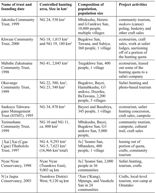
Table 3 Community based organizations in Botswana’s Northwest District (Ngamiland) and Namibia’s Tsumkwe District that are involved in integrated conservation and development activities
Name of trust and
founding date Controlled hunting
area, Size in km2 Composition of population, population size
Project activities Jakotsha Community
Trust, 1999 NG 24, 530 km2 Mbukushu, Herero and Ganikwe San, 10,000 people, multiple villages
community tourism, makoro (canoe) poling, basketry and other craft sales Khwaai Community
Trust, 2000 NG 18, 1,815 km2
and NG 19, 180 km2 Bugakwe San, Tawana, and Subiya, 360 people, 1 village
ecotourism, craft sales, work at safari lodges, auctioning off of a portion of the hunting quota Mababe Zukutsama
Community Trust, 1998
NG 41, 2,045 km2 Tsegakhwe San, 400
people, 1 village ecotourism, leased out some of the hunting quota to a safari company Okavango
Community Trust, 1999
NG 22, 580, km2,
NG 23, 540 km2 Bugakwe, Bayei, Hamubkushu, G
anikwe, Dxeriku, BaTawana, 2,200 people, 5 villages
Safari hunting and photo-based tourism
Sankuyo Tshwara- gano Management Trust (STMT), 1995
NG 34, 870 km2 Bayeei and Basubiya,
345 people, 1 village ecotourism, safari hunting concession, craft sales, campsite Teemashane
Community Trust, 1999
NG 10 and NG 11,
ca. 800 km2 Mbukushu, Bayei, Bugakwe San, G
anikwe San, 5,000 people,
community tourism, campsite, cultural trail, craft sales
XaiXai (Cgae Cgae) Tlhabololo Trust, 1997
NG 4, 9,293 km2 NG 5, 7,623 km2 (16,966 km2 total)
Ju’hoansi San, Mbanderu, 400 people, 1 village
leasing out of portion of quota, crafts, community tourism
Nyae Nyae
Conservancy, 1998 Nyae Nyae (Tsumkwe East), 9,003 sq km
Ju’hoansi San, 2,000 people in 36
communities
Safari hunting, tourism, crafts Na Jaqna
Conservancy, 2003 Tsumkwe District
West, 9,120 sq km !Xun (!Kung), Mpungu, and Vasekele San in 24
communities
Crafts, local-level tourism, rest camp at Omatako
South Africa ruled that the Nama of the Richtersveld, who had filed a claim in 2000 but had seen it dismissed by the Land Claims Court, had rights to land as well as to mineral resources in the Richtersveld (Alexor v. Richtersveld Community). This successful legal decision allowed the Richtersveld community ‘the right to exclusive beneficial occupation and use, akin to that held under common law ownership’ of the subject land’ (Chan 2004: 120). The Supreme Court of Appeal of South Africa cited aboriginal title articles and cases as precedents in this decision but left open the question of whether or not the land was being granted under aboriginal title.
In Namibia, the Khwe of West Caprivi sought legal help from the Legal Assistance Center in the late 1990s when the government of Namibia announced a decision to establish a prison farm on land where the Khwe had a community campsite along the Okavango River. Eventually, the government backed down and located the prison farm a short distance away, so no case was heard in court. But the threat of legal action obviously had some impact on the decision by the Namibia government as to where to put the prison farm.
In Botswana, the people of the Central Kalahari Game Reserve filed a claim for the restoration of services in the Central Kalahari Game Reserve of Botswana after the government had decided to remove San and Bakgalagadi residents of the reserve in 1997 and in 2002 (Hitchcock 2002; Ikeya 2001). This case, which was on-going at the time of writing, was being argued before the High Court of Botswana by a team of lawyers working on behalf of a group of San and Bakgalagadi who had been told to leave the reserve and had been resettled with government of Botswana assistance in three settlements on the peripheries of the reserve. As Roy Sesana, the head of First People of the Kalahari, a San advocacy organization, told a group of San delegates from northern Botswana in 1998: ‘Our human rights are our land’
(Taylor 2004: 155). The Central Kalahari Game Reserve case, which has received worldwide attention in the past two years, pits a group of San and Bakgalagadi against the government of Botswana, which has considerable resources at its disposal to defend its position legally and to engage in wide-ranging public relations efforts.
While it is uncertain whether the San and Bakgalagadi will prevail in their efforts to have their land and resource rights in the Central Kalahari restored, there is no question that San land and resource claims are getting national, regional, and global attention. A number of San have said that they would be satisfied to enter in to negotiations with the government of Botswana over the Central Kalahari Game Reserve in the hopes of coming to a settlement that would allow at least some former residents of the reserve to return to their ancestral territories in the Central Kalahari.
The question remains whether or not those people who in the past relied on
hunting and gathering as part of their economic system will be able to continue to
obtain wild animals and plants or whether they will have to turn instead to other
ways of earning their subsistence and income. In Botswana, the Special Game
License, a subsistence hunter’s license that allowed San and other people to obtain
wild animals for consumption purposes, was done away with by the Botswana government in 2002, although it should be noted that some people living in settlements near the Central Kalahari Game Reserve continued to receive Special Game Licenses up until recently. The Ju’hoansi of the Nyae Nyae Conservancy in Namibia have the right to hunt as long as they use traditional weapons and methods, but this is not true for their neighbors in Tsumkwe District West. San in other parts of Namibia do not have subsistence hunting rights.
STEPS TOWARD GREATER LAND AND RESOURCE RIGHTS FOR KALAHARI SAN
There has been extensive debate in southern Africa over the rights of San peoples to land, natural resources, development, and cultural identity (Saugestad 2001; Cassidy, Good, Mazonde, and Rivers 2001; Suzman 2001a, b; Hitchcock 2002). On the one hand, organizations and individuals, including many San, have sought to protect and promote San rights. On the other hand, southern African governments, both past and present, have attempted to assist San through the provision of development programs that were based on the assumption that San would agree to integrate into the nation-states of the countries in which they resided.
As has been shown, some San resisted the assimilation efforts of southern African governments. This resistance took a number of forms, including taking part in non-violent demonstrations against government policies, going to court to obtain recognition of land and resource rights, and engaging in public relations campaigns to bring pressure to bear on governments and local authorities to ensure human rights for San.
One of the strategies of the San in their efforts to promote their rights has been to engage legal advisors. San have sought help from lawyers in Botswana, Namibia, and South Africa. In some cases, the legal advisors have provided advice, usually
pro bono, to San communities and individuals. In other cases, they have defendedSan in court, as has occurred in Botswana and Namibia in cases involving alleged poaching. In still other cases, lawyers have initiated legal proceedings against the governments of southern African states on behalf of San and other clients.
In Botswana, there were cases where San who were dispossessed of their land
and water rights sought to appeal the decisions by district councils and land boards
to Central government ministries. This was done by San in Kgatleng District, for
example, who requested the Minister of Local Government and Lands to intervene
in a decision of the Kgatleng Land Board to shut down remote area settlements in
the northwestern part of the district. In all three countries where San exist in sizable
numbers in southern Africa (see Table 4), San have engaged in legal actions and
have sought the help of non-government organizations such as the Legal Assistance
Center of Namibia, Ditshwanelo, the Botswana Center for Human Rights, and the
Legal Resources Center in Grahamstown, South Africa. In some cases, San have
voted with their feet, moving back into areas from which they had been removed in
order to re-assert their occupancy rights. Such a strategy was employed, for example, by Gui and Gana San and Bakgalagadi from the Central Kalahari Game Reserve in the period after they were removed from the reserve in 2002.
A number of San groups have written letters to government officials, including the presidents of the respective countries in southern Africa, in an effort to secure greater recognition of their rights. There have also been efforts by San organizations, including First People of the Kalahari, to utilize the worldwide web to make their case for the formal recognition of land and resource rights for San. Some San organizations have also held press conferences where they have answered questions from the media on issues that they are facing.
When San spokespersons describe the human rights situations they are experiencing, they often point to (1) poverty, (2) lack of secure land and resource rights, (3) lack of cultural rights (for example, the right to teach and learn mother tongue San languages), (4) lack of civil and political rights (for example, the right to choose their own leaders), and (5) lack of intellectual property rights (for example, the right to control and benefit from traditionally important wild plants) (Suzman 2001a, b; Saugestad 2001; Hitchcock 2002; Hitchcock and Vinding 2004). It should come as no surprise, therefore, that San are seeking actively to gain greater recognition of their rights at the local, regional, national, and international levels.
CONCLUSIONS
Several lessons can be drawn from the experiences of San who have worked hard to obtain legal land and resource rights. First, the notion that San have land and resource rights as citizens of the countries in which they reside may be true in principle, but in practice these rights are often not observed by governments and local authorities. While all three southern African governments have claimed that the San are full citizens of their countries, San have experienced difficulties in getting legal control over land and resources.
One of the more successful strategies employed by San is to take part in
Table 4 Data on southern African countries’ overall population size, area, and numbers ofSan
Country Population Size (November, 2005 estimate)
Size of Country
(square kilometers) Population Size of San
Botswana 1,640,115 581,730 48,000
Namibia 2,030,692 825,418 38,000
South Africa 44,344,136 1,219,916 7,500
TOTALS 48,314,943 people 2,627,064 sq km 93,500
Note: Data obtained from the Southern African Development Community (SADC), The World Factbook (2005), and the Working Group of Indigenous Minorities in Southern Africa.