Agricultural Environment of the Back Land of
Nagura Bay, Okinawa Prefecture
著者
KATAYAMA Tadao C., SHINAGAWA Akio, HIGASHI
Teruo
journal or
publication title
南海研紀要
volume
6
number
1
page range
37-55
URL
http://hdl.handle.net/10232/15660
Mem. Kagoshima Univ. Res. Center S. Pac. Vol.6, No. 1, 1985 37
Agricultural Environment of the Back Land of
Nagura Bay, Okinawa Prefecture*
Tadao C. Katayama**, Akio Shinagawa*** and Teruo Higashi***
Abstract
The agricultural environment of the back land of Nagura Bay, Ishigaki Island,
Okinawa Prefecture, /'. e., upland factors and cropping systems were discussed on the
basis of references and observation in the area. There is a rapid consumption and a
high turnover rate for organic matter, nutrients, minerals. To improve soil preserva
tion, it is recommended utilization of natural topographical features and plants is more
suitable than building artificial structures. Plants with a tap root and deep-rooted trees
are good examples of natural stabilization structures. In comparison to the agricultural
practices dominated by hand labor and small machines, procedures utilizing large
machines are disadvantageous, because they increase the amount of times the landremains bare and they reduce the necessary elasticity in farm practices. It is recom
mended to increase the agricultural development cautiously to preserve the environ
ment and to keep the local population consensus.
Introduction
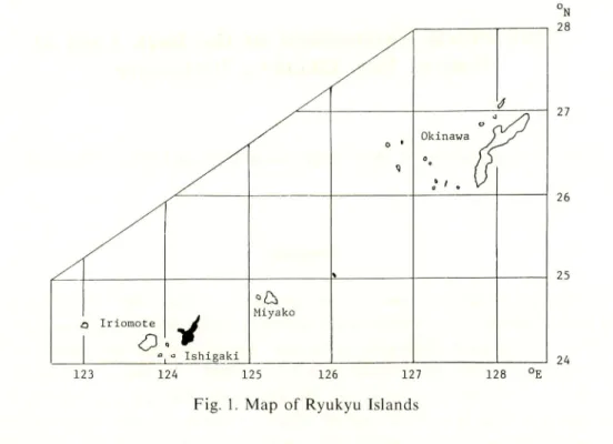
Ishigaki Island lies between 124°04'E and 124°20'E longitude and 24°19'N and 24° 36'N latitude (Fig. 1). In general, Ishigaki Island is said to be characteristic of a
sub-tropical region. Because of its sub-tropical nature, it has higher temperatures and
more abundant solar energy in comparison with Japan proper. Due to the favorable
environmental conditions, development of agriculture should be emphasized in the
future. Unfortunately, this environment is also favorable for insects and other pests
and makes storage of food more difficult (Okinawa Development Agency, 1979).
Technical and productive aspects of agriculture on this island are unstable due to
typhoons and long droughts. When planning agricultural development, it is always
* this study was a contribution to "The Water-Land Interactive Systems Project", United NationsUniversity (July, 1980).
Experimented Farm, Faculty of Agriculture, Kagoshima University, Kagoshima 890, Japan. * * *i&jii8B*, m mm.
38 KATAYAMA et al. : Agricultural Environment of Back Land of Nagura Bay j o • Okinawa j
rP
/ \ i3 Iriomote<9
° Ishigaki Miyako 123 124 125 126 127Fig. 1. Map of Ryukyu Islands
128 °E N 28 27 26 25 2k
necessary to understand and balance the favorable natural conditions and the unfavor
able natural disasters.
In this report, the agricultural environment of the back land of Nagura Bay, /. <?.,
upland factors and cropping systems are discussed on the basis of references and
observations in the area.
Climate
Although meteorological data are gathered at 6 points on Ishigaki Island, the
informations obtained from the Ishigaki Meteorological Observatory are seen to be
replete, and will be used in this roport (Government of Ryukyu, 1968).
The yearly average temperature is recorded as 23.7°C. Monthly average tempera
tures vary from 29.0°C in July to 17.8°C in January. The highest monthly average temperature recorded is 32.TC in July (the extreme value; 35.4°C on September 15,
1899), and the lowest is 15.4°C in January (the extreme value ; 5.9°C on February 19,
1918). No frost is said to occur here.
There are 238.4 days a year with the maximum daily temperature over 25.0°C and 104.6 days a year with the maximum daily temperature over 30.0°C. August has 31.0 days and 26.1 days with the maximum daily temperatures over 25.0°C and 30.0°C, respectively. There are 156.4 days a year with the average daily temperature over 25.0°C and 7.6 days a year with the average daily temperature over 30°C. August has 31.0 days and 5.5 days with the average daily temperture over 25.0°C and 30.0°C, respectively.
Mem. Kagoshima Univ. Res. Center S. Pac, Vol. 6. No. 1. 1985 39
There are 114 days that can be classified as "mid-summer day" and 94 days that can be classified as "tropical night". This data supports the conclusion that Ishigaki Island
belongs in the sub-tropical classification.
Soil temperatures at 0.5 m depth are recorded as 25.0°C for the yearly average.
30.2°C as the highest average occurs in July (the extreme value ; 32.7°C, in July, 1956). Rainfall is recorded as 2,097.4 mm for the average yearly total. 219.9 mm is
maximum monthly average occurring in September. The maximum rainfall in one day
is recorded as 378.9 mm on July 22, 1935. The maximum rainfall in one hour is
recorded as 111.8mm on November 1, 1944. The maximum rainfall in 10 minutes is recorded as 38.2 mm on March 30, 1937.
It is characteristic of this island that rainfall data varies considerably from year to
year. For example, over a 70 year period, the maximum and the minimum monthly
rainfall for May are found to be 732.5 mm in 1898 and 0.6 mm in 1963. These
variations occur in rainfall patterns every month. The maximum and the minimum yearly rainfall for the same 70 year period are found to be 3.371.2 mm in 1966 and 1,271.6 mm in 1963. These variations are mainly due to typhoons and variable rainy
s e a s o n s .
There are 208.6 days through the year with over 0.1 mm of rainfall daily (20.1 days in December, the maximum for one month), 146.5 days through the year with over 1.0 mm of rainfall daily (14.2 days in December, the maximum for one month), 54.1 days with over 10.0 mm of rainfall daily (5.6 in May, the maximum for one month), 18.9
days with over 30.0 mm rainfall daily (2.2. days in May, the maximum for one month),
8.9 days with over 50.0 mm of rainfall daily (1.2 days in May, the maximum for one month), and 2.4 days with over 100.0 mm of rainfall daily. Because rainfall in the mountainous areas is generally 1.5 times more abundant than the plains, rainfall data
for Mt. Omoto located in the back land of Nagura Bay, is probably higher than the average rainfall data mentioned above.
Continuous non-rainfall days are worthy of attention, because they fundamentally affect agricultural practices, and are recorded as frequently occurring in these areas. In
1963, there was no rainfall during the 38 days from April 26 to June 2. In 1971, there was no significant rainfall for 191 days from February to September, with only a minimal rainfall occurring on the 39 th day of the drought. Every year, without exception, a 20 day period with no rainfall is recorded.
Much evaporation occurs during July and August. Total annual evaporation is
recorded as 1,662.8 mm Evaporation of 198.4 mm in July is the maximum monthly
average throughout the year. Extreme values are recorded as 1,837.3 mm in 1964 and 267.5 mm for extreme monthly evaporation in July of 1956.
Relative humidity is remarkably influenced by the typhoon and rainy seasons.
Relative humidity is recorded as 80 %for the yearly average and as 85 % in June as the maximum monthly average. The extreme value is recorded as 28 %for the lowest level
on May 18, 1948.
40 KATAYAMA et al. : Agricultural Environment of Back Land of Nagura Bay
November as the maximum monthly average. The winds blow from NNE and NE for 15.0 %and 14.3 % of the time, respectively. The maximum wind speed was recorded as
50.3 m/s on September 17, 1933 (so-called Ishigaki-jima Typhoon, 946.9 mb). The maximum instantaneous wind speed is recorded as 57.2 m ESE on July 5, 1948 (6th
Typhoon, 967.7 mb).
There are 40.0 days, 5.8 days and 0.7 days throughout the year with winds blowing 10.0-14.9 m/s, 15.0-28.9 m/s and over 29.0 m/s, respectively.
Sunshine hours are recorded as being 2,047.6 hours as the yearly average and 274.7 hours in July as the maximum monthly average for the year. These extreme values are recorded as 2,448.9 hours as the yearly average in 1963 and 358.4 hours as the monthly
average in July 1957.
Clear days (cloud amout 0.0-2.4) are recorded as 25.1 days as the yearly average and 3.7 days in September as the maximum monthly average. These extreme values are
recorded as 57 days for the yearly average (1967) and 15 days for the maximum monthly
average in August, 1926. Cloudy days (cloud amount 7.5-10.0) are recorded as 193.9
days for the yearly average and 20.6 days in January as the maximum monthly average.
These extreme values are recorded as 226 days for the yearly average in 1953 and 31
days for the maximum monthly average in January, 1944. Non-sunshine days are
recorded as 41.8 days for the yearly average and 6.2 days in December for the maximum monthly average. These extreme values are recorded as 78 days for the yearly average in 1899 and 15 days for the maximum monthly average in December, 1961.
Thunder and lightning, and fog days are recorded as 21.7 days and 4.7 days for the yearly average, respectively.
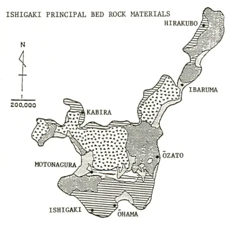
Principal Bed Rocks
Chinzei et al. (1967) reported the bed rock geology of Ishigaki Island as follows
(refer to Fig. 2).
The bed rocks are gouped into the following 5 categories.
Paleozoic rocks consist mainly of green schist, in which chlorite, actinolite and
epidote are the dominant minerals. Calcite occurs in veins, disseminated phyrite occurs
as small specks and milky quartz appears thin layers. It is located in the northern half
of Hirakubo Peninsula and Sakieda Peninsula. There also coexists blue schist and
dark gray schist with different mineral compositions from the green schist. In the central northeastern part of the island, metamorphic Paleozoic rocks intersect moun tains of granite and andesite. The metamorphic rocks consist mainly of a thick series
of schists with some interbedded chert, quartzite, sandstone, conglomerate, phyllite,
and hornfels. In the southwestern part of Ishigaki Island, the rocks are chert schist, phyllite, conglomerate, metamorphosed sandstone, shale hornfels, marble and andesite. The first three are the most abundant in the southwestern part.
Mem. Kagoshima Univ. Res. Center S. Pac, Vol. 6, No. 1, 1985
ISHIGAKI PRINCIPAL BED ROCK MATERIALS rvr
HIRAKUBoJPt^
IBARUMA OZATO ISHIGAKI OHAMA 41Fig. 2.
Principal bed rock materials of Ishigaki Island (Chinzei et at., 1967)
Because of geological complexity, the island of Ishigaki has the most varied
bed rock materials among the three islands (Okinawa, Miyako and Ishigaki).
The
bed rock materials are shown here in five categories, of which the most dominant ones are (1) Paleozoic rocks, igneous rocks and old alluvium (siliceous) and (2) Ryukyu limestone (calcareous). The soils underlaid by these bed rock materialsreceive a great influence from the bed rock materials in their characteristics; and
consequently pineapple on siliceous soils and sugarcane on calcareous soils have become the most important crops on this island.
HH
Paleozoic rocks : Green (epidote, chlorite and actinolite) schist, blue (glaucophane
and crossite) schist, dark-gray schist (carbonaceous) schist, phyllite and chert.
LV'j Igneous rocks : Biotite granite, andesite, volcanic breccia and tuff.
Ryukyu limestone: Sandy foraminiferal limestone and detrital coralliferous
limestone.
t=l
Old alluvium : Unconsolidated gravel in a reddish to yellowish-red soil-like
matrix with lenses and bed of clay, sand, cobbles and boulders.
[K&il
Alluvium and beach deposit: Unconsolidated deposits of clay, silt, and gravel
unconsolidated deposits of beach sand and gravel on present beaches and of
42 Katayama et al. : Agricultural Environment of Back Land of Nagura Bay
southern half of the helve (Hirakubo Peninsula) at the northern side of the island. On the Sakieda Peninsula and on the base of the Hirakubo Peninsula, the primary rocks are a series of andesitic lavas, breccias, and tuffs. The rocks intrude older rocks and
in places overlaid by the Ryukyu limestone and old alluvium. In the central northern
part of the island, the highest mountain (525 m) in the Ryukyu Island is composed of
granite that is mostly biotite granite with variations of granodiorite at the southern
base and of granophyres at the western base of the mountain.Ryukyu limestone is very extensive in the southern part of the island except on the
highest mountains.
It occurs extensively over Paleozoic and igneous rocks.
Two
principal types of Ryukyu limestone are recognized in Ishigaki Island.
One is a
stratified sandy foraminiferal limestone and other is a detrital coralliferous limestone.
At the places where both are present, the sandy limestone underlies the coralliferous
limestone.Old alluvium occurs as terraces at the base of the granitic mountains in the central area of the island. This alluvium consists of a heterogeneous mixture of clay, sand,
gravel and larger fragments of rocks. The alluvium underlies or overlies limestone in
places so that deposition seems to have continued for a long period of time, beginning
in the post-Miocene period.
Recent alluvium unconsolidated river deposits are found along streams and at the
mouth of the rivers.
Coarser deposits are found up-stream and finer deposits exist
downstream. Alluvium extends most widely on the western side of the island. Sandy
beach deposits exist at all edges of the seashore but the largest deposits are in the
southwestern part of the island.
Soils
Yamada et al. (1973) surveyed the soils of Ishigaki and other islands of Okinawa
Prefecture in 1964 and 1966. They made a soil map (Fig. 3) according to the Japanese
soil classification system, and described the soils of Ishigaki Island as follows.
Soils of arable land in Ishigaki Island were classified into 6 general groups, i. e.,
red yellow soils, reddish brown soils, brown lowland soils, gray lowland soils, gley
soils and muck soils. Twenty nine soil series were established.
Red yellow soils are widely distributed on rolling to gently sloped higher terraces
around the central mountain area and on the hilly area of eastern part of Ishigaki Island. About 50 % of the total arable land is composed of red yellow soils.Most of the red yellow soils on this island were derived from various kinds of
metamorphic rocks, such as green (epidote, chlorite, and actinolite) schist, blue
(glaucophane and crossite) schist, dark-gray (carbonaceous) schist, phyllite and chert.
Soils derived from igneous rocks such as andesite, granite, granodiorite, and the
diluvial gravel layer (so-called Nagura gravel layer which corresponds to the Kunigami
Mem. Kagoshima Univ. Res. Center S. Pac. Vol.6, No. 1, 1985
Fig. 3. Soil map of Ishigaki Island (Yamada et aL, 1973)
j] Red and yellow .soils H£ dray lowland soils
Reddish brown soils [>;v:V:| Gley soils
Brown lowland soils 1^\\\\] Muck soils
43
Red yellow soils are characterized by the occurrence of a B horizon of red to
yellow color whose chroma is higher than 6 in the Munsell color notation. The texture
is generally fine to very fine in A horizons, and very fine in B horizons. The clay
contents of B horizon are generally higher than 30 %, except for soils derived from diluvial sand. Illimerization (eluviation and accumulation of a clay substance without the destruction of the clay component), high acidity, and absence of a humus horizon in the profile are also main characteristics of this large group. pH (H20) is lower than
5.0 and pH (KC1) is lower than 4.0. The base saturation degree is less than 35 96.
Clay mineral composition of red yellow soils is somewhat different depending on
the parent material. In the Omoto series derived from granodiorite, for example, the dominant clay minerals are illite and kaolin mineral (probably metahalloysite) with a small amout of vermiculite and a mixed mineral layer of vermiculite and illite. Soil derived from siliceous metamorphic rocks are predominantly vermiculite, mixed
44 KATAYAMA et al. : Agricultural Environment of Back Land of Nagura Bay
mineral layer and kaolin minerals. The clay mineral composition of the Nosoko series whose parent material is andesite seems to be a combination of the above two. Chlorite
is found in the A and/or B: horizon of Omoto and Nosoko soil. Gibbsite, goethite and quartz are found in all the red yellow soils of Ishigaki Island as accessary minerals. A
strong endothermic peak was found at about 300°C in the differential thermal analysis
curve of all soils tested.
Most of the red yellow soils are used for producing pineapples. They are partially used in upland fields for sweet potato, tobacco and grazing lands.
Seventeen soil series were established from the red yellow soils according to their texture, thickness of solum, color of control section of the profile and the kind of parent material.
Reddish brown soils are the soils derived from unconsolidated sediments on raised
coral limestone, and are widely distributed on the coastal terraces throughout Ryukyu Island. On Ishigaki Island, these soils are distributed on the medium to low flat terraces with altitudes less than approximately 100 m along the seashore. About 30% of total arable land is covered by reddish brown soils, and it is mostly used as upland
fields for sugarcane production.
The Ap horizon is dark grayish brown in color and has fine to very fine texture.
The humus content is 2 % or less. The B horizon is reddish brown in color and has a
very fine texture. The angular blocky structure is moderately developed. The degree
of illimerization is not as high as in the case of the red yellow soils, but the clay skins
are generally found on the face of the structure and/or pores. The reaction is slightly
acid to slightly alkaline in all horizons. The soils having deep solum are slightly acid, generally. Exchangeable cations, especially calcium, are very high in content. The base saturation degree is 60 % or greater.
The dominant clay minerals of reddish brown soils are illite and kaolin minerals.
o
Occasionally, there is a small amount of 14 A mineral which is probably vermiculite.
Four soil series were established from the reddish brown soils according to their
depth of solum and the color of the B horizon.
Brown lowland soils are the soils formed under well drained conditions, and are
characterized by the occurrence of a brown colored B horizon. These soils are mostly
distributed on the natural levee in the lowland area, and particularly on terrances.
They are generally coarser textured and excessively drained. Brown lowland soils in Ishigaki Island are subdivided into 5 soil series by the texture of profile, appearance of a gravel layer, the humus content of the A horizon and the occurrence of a calcareous
sand layer.
Gray lowland soils are characterized by their thick gray to grayish brown horizon.
Most of the gray and grayish brown horizons are formed during the soil forming
processes under the influence of ground water or artificially irrigated water. Some of
them have inherited the color of the parent material, as in the case of marine or
lacustrine deposits. These soils are formed generally under well drained conditions,
Mem. Kagoshima Univ. Res. Center S. Pac, Vol. 6, No. 1, 1985 45
Gley soils are formed in the ill-drained areas, and are characterized by the
existence of a gley horizon, which is bluish gray in color and has a high content of
active ferrous iron. Tubular mottlinges are sometimes found in gley horizons.
On Ishigaki Island, the distribution of gley soils was found to be on the narrow valley plains along the Rivers Miyara, Todoroki, etc. Only one series, the Miwa Series was established. Most of the gley soils are used as paddy fields.
Muck soils are formed under ill-drained conditions such as in the margin of Peat
or Peaty soils. The main morphological characteristic is the existence of a black
colored muck horizon which also consists of some peat. A muck horizon is
commonly-underlaid by peat or a peaty horizon. This group seems to be an intergrade between
peat soil and gley soil. Organic carbon content of the muck horizon is usually higher
than 10%.
Forest
Forest land is recorded to be 8,306 ha on Ishigaki Island and occupies 36.62 % of
the total land mass (22,679 ha) (Department of Agriculture, Forestry, and Fisheries,
Okinawa, 1979). The forest of which 7,863 ha is stocked area, is divided into 2
categories, i. e., made forest (1,011 ha) and natural forest (6,852 ha). The
man-made forset has 662 ha of needle-leaved trees and 349 ha of broad-leaved trees. The natural forest has 33 ha of needle-leaved trees and 6,819 ha of broad-leaved trees.
Needle-leaved trees in the natural forest are mainly Luchu pine and Podocarpus
macrophylla. Broad- leaved trees in the natural forest mainly consist of Castanopsis
cuspidata, Distylium racemosum, Quercus miyagii and Peroea tunbergii. Trees in the
man-made forest are Luchu pine, Calophyllum inophyllum, Casuarina stricta, Podocar
pus macrophylla and Carcinia subelliptica. Luchu pine makes up 80% of the planted
trees. The government encourages afforestation of the numerous indigenous tree
species, including Cryptomeria (Okinawa Prefectural Office, 1978-1979).
The reckless deforestation in some areas disturbs the fundamental functions of the forest. These functions include headwater conservation, wind break, salty wind
protection and sand prevention.
Agriculture Development
On Ishigaki Island, agricultural land has an area of 3,993 ha, which is roughly divided into 2 groups. They are 468 ha of paddy fields, and 3,525 ha of upland fields. The percentage of upland field to the entire agricultural land is 88 %. The crops produced are sugarcane, pineapple, a first cropping of rice, a second cropping of rice,
open-field vegetables under structure and fruit trees. These have areas of 1,279 ha, 1,359 ha, 346 ha, 74 ha, 409 ha, and 9,600 m2, respectively. Livestock consists of beef
46 KATAYAMA el al. : Agricultural Environment of Back Land of Nagura Bay
cattle, dairy cows, pigs, chickens and buffalos. Their numbers are 8,109, 127, 8,455,
39,253 and 180, respectively. Large agricultural equipment consists of 285 riding
tractors, 77 walking tractors, 77 combines, 5 sugarcane harvesters and 345 machines for pesticide application. Buildings for the rice center (684 m2) and for the storage of rice
(1,000 m2) are thoroughly furnished.
Because there are few irrigation systems, crop cultivation is dependent on natural rainfall (so-called rainfed style). Several crops are frequently devastated due to drought
conditions.
Due to the growing flexibility in economic and social practices, the trends in
agricultural practices such as crop selection, strain selection and optimum location are
being studied more closely every year. Recently, the properties of the red and yellow soils of Okinawa Prefecture for agricultural practices were published (Extention Office, Department of Agriculture, Forestry and Fisheries, Okinawa, 1977) (Table 1).
The main crops and agricultural practices of Ishigaki Island are discussed in the
following, based on information (Yaeyama Extension Office for Agriculture, 1980),
and observation in the area.
Sugarcane is a major crop on Ishigaki Island and throughout Okinawa Prefecture.
The cropping systems consists of 3 patterns, /. e., summer planting, spring planting and
ratooning methods. Retooning methods are recommended to be limited to 3 times, however, it is usually done more than 3 times now. Certain strains of sugarcane have been weakened yearly due to poorly managed cultivation. By assigning to much importance to chemical fertilizers and applying continuous cropping by the ratooning
method for extended periods of time, soil fertility decreases, especially becoming
deficient in organic components. In some cases, the phenomenon of bud-sprouting is an important problem.
Industrial factories for sugarcane on Ishigaki Island have a capacity for 52,000 tons of material per year, but they can not operate at full capacity due to a shortage of crude
materials. Remnants and theriac are put to practical use for bagasse and roughage, respectively, and bagasse and ramnant arising from the factories are mixed together and applied as organic fertilizers (Department of Agriculture, Forestry and Fisheries,
Okinawa, 1980).
Deep cultivation practices make it possible for crops to withstand droughts. However, sugarcane still wilts when there are up to 40 consecutive days with no precipitation. From March to April, no cultivation occurs, the ground is left in bare
status and there is often severe soil erosion. There is limited rainfall during the spring
and summer planting seasons and unfortunately drought like conditions may damage sprouting. To prevent this phenomena, green gram is sown into the fields as green manure in April and then plowed-in to the soil after it reaches a mature stage. This
practice is especially important for hillside farmland. Insects, smut, leaf scorch and
Anomala xanthopleura, all pests to the sugarcane crops, are abundant in the area. The
government has issued grants for a cooperative control program. Herbicides are not frequently used (Department of Agriculture, Forestry and Fisheries, Okinawa, 1979).
Table
I.
Recommended
properties
of
red
and
yellow
soils
in
Okinawa
(Extension
Office,
Department
of
Agriculture,
Forestry,
and Fisheries, Okinawa, 1977) Sugar Pine Paddy* Citrus Tea Upland Grazing Vinyl** cane apple rice fruit field land house pH (H20) CEC (me/100 g) 5.5-6.5 12< 4.5-5.5 I2< 5.5-6.5 12< 5.0-6.0 12< 4.5-5.5 12< 5.5-6.5 12< 5.5-6.5 12< 5.5-6.5 12< Exchangeable Ca base (ne/100 g) Mg K 6< 2< 0.5< >1> 0.5< 0.5< 6< 2< 0.5< 6< 2< 0.3-0.5 >5> >1> 0.3-0.5 6< 2< 0.5-1.0 6< 2< 0.5 6< 2-3 0.5-1.0 Base saturation degree per cent 70 < 60 > 70 < 60 < 60 > 70 < 70< 70-80 Available P205 (mg/IOOg) I0< 5< 10< 10< I0< 10< I0< I0< Plow layer (cm) 40 < 25 < 20 < — — 20 < — 20 < Available soil depth (cm) 60 < 35 < 50< 60 < 60 < 30 < 50 < 50< Available water (FC-pF 3) mm 60 < 35< — 60 60 < 30 < 50< 50 < Gaseous phase (pF 1.5) per cent 20 < 25< — 25< 25 < 25 < 25< 20 < Hardness of available soil (Yamanaka's hardness tester) 24 < 20 > 24 > 20 < 20> 24 > 24 > 24 > Coefficient of permiability cm/sec. 10-4< 10~3-I0 4 I0-5-10-6 I0"4< io-3-io-'< io-j< io-*< 10-4 * Water percolation : 20-30 mm/day; available Si02: 25 mg/IOOg * * Electric conductivity 1.0 mQ (1 : 5) n z o48 KATAYAMA et al. : Agricultural Environment of Back Land of Nagura Bay
After the establishment of Nagura Dam, production of sugarcane is expected to increase from 6 ton/ha to 10 ton/ha. NCo 310 is the main variety of sugarcane in this area at the present time, but varieties such as F146, F160, will probably be important
in the future. They require more water than other varieties to complete their life cycles.
Pineapples are as important crop as sugarcane on Ishigaki Island. Pineapple cultivation has been recorded as occurring since befor World War II. During the war, cultivation took place scattered throughout the mountainous areas. After the war, the cultivated areas were established and recently new varieties have been introduced from
Thailand and Hawaii.
The following environmental conditions are recommended for pineapple cultiva tion ; sunshine, hillside within 15° incline, flat area, and an area easily accessible for marketing. At present, pineapple cultivation is located in so-called unfavorable areas, which have few of the above mentioned characteristics. Pineapple is a most conspicu
ous crop in view of the soil erosion. The following techniques are recommended to prevent soil erosion ; drainage canals in a large scale and grass cultivation. These techniques are not enough to ensure against erosion occurring during concentrated
heavy storms.
It is assumed, in general, that land having angles less than 3°, between 3° to 8° and
greater than 8° inclinations represent flat, slack hill and hill farms, respectively. To
improve pineapple cultivation, it is recommended to restyle the landscape, to regulate the inclination within 8°, to enlarge the individual divisions, and to adjust the management practices. Rental land systems are one of the obstacles against applying
these recommendations.
Pineapples usually are harvested 5 times a year. They are utilized as fresh fruit or
for canned products. However, canning factories can not operate at full capacity due
to a shortage of crude materials.
Generally older plants are replaced by seedlings after several years. It takes a year to the first harvest after planting a seedling. Fields are left as bare ground between harvesting and follow up plantings. Soil erosion is extensive during this period, and cultivation for the production of green manure has been recommended. At the present
time however, this recommendation has not been acted upon.
Planting is almost totally mechanized, and the germination is said to be better than
that of hand planted. The harvesting is almost all done by hand. The techniques of
plowing-in the leaves and stems are recommended to return nutrients to the soil by the government. If these techniques are adopted, however, some diseases such as core-rot become a serious porblem, especially in the case of August planting. It is sometimes difficult to utilize machinery owing to the strong rain type.
Remnants of the pineapple plant, such as hard fibrous material often flow down to the Nagura Bay and accumulate at the bottom of the reef for long periods of time
without rotting.
Rice has a long history of cultivation on Ishigaki Island. Its cultivation has a strong connection with other islands. There are the several famous regions of rice
Mem. Kagoshima Univ. Res. Center S. Pac. Vol.6, No. I, 1985 49
cultivation from old times. Rice cultivation had an area of 1,100 ha in the past, but only approximately 400 ha are used at the present. All cultivation is of non-glutinous
varieties.
Rice fields located more than 1,000 m from the seashore, currently have no serious drainage problem. However, damage from ill-drainage may become an important problem in the future, because some of these fields do lie in valleys or swampy areas. Drainage canals are found only near Motonagura and Okita Bridges on a small
scale. Generally, there in a lack of drainage ditches. In these areas, cultivation is
determined by whether or not a buffalo can plow the field. Rice cultivation is not done in an area that a buffalo can not efficiently plow. Historically, ill-drained conditions and low soil fertility were key problems in a second cropping of rice. Seeds grown after harvesting of the first cropping of rice are used generally for seed production and not for sale. Whether a plant will sprout or not after harvesting the first crop, is an indication of soil fertility. It is concluded that ill-drained conditions and soil fertility are related to one another. High temperature of irrigation water is also a problem
pertaining to the second crops.
Rice cultivation in the Nagura region in mostly done by the people of 3 villages
of the Ishigaki region. Their fields and houses are located some distance from each
other. When 8 ha are cultivated by only 1 farmer, the time required is great. These facts contribute to poor grain quality and a lack of cooperative preventive works. Five ha per farmer is the optimum farm size to obtain high quality and quantity crops for rice. The first cropping for rice is usually from February 8 to July 13, a total of 120 days. The second cropping of rice is usually from July 31 to November 28, 105 day duration. Average yields are 270 kg/10 a for the two croppings. Four hundred fifty kg/10 a and 280 kg/10 a are recorded as the maximum for the first and the second cropping periods, respectively. Toyonisiki, Taichung No. 65 and Nagoyutaka are the
most popular varieties of rice used. It is assumed that these three varieties are used both in the first and the second cropping periods.
Most of the cultivation is done by hand, though 10 combines, 5 drainers, 30 powered rice-transplanters, 2 powered huskers and 20 powered threshers are registered in the region. Straw is usually restored to the rice fields.
There are several diseases such as blast, sheath blight and brown spot, that affect the crops but no cooperative prevention program has been established. An increase of rice production is expected after the establishment of the irrigation-drainage-systems, which are expected to be completed with the Nagura Dam.
Vegetables cultivated on Ishigaki Island are tomatos, pumpkin, okura, taro, a kind of Chinese cabbage, green peppers, watermelon, balsam pear and water convolvulus. The convolvulus is not being cultivated at the present time, because it requires
abundant water during its life cycle. Some vegetables are cultivated on the "home
garden system" on a small scale. Fruits such as bananas and papayas are co-cultivated
in this system.
house-50 Katayama et al.: Agricultural Environment of Back Land of Nagura Bay
culture is adopted extensively. The products are consumed on Ishigaki Island and also marketed in Japan proper from January to April. They have a difficult time with the selection of vegetables, e. g., the vegetables must be adaptable to the mid-summer
conditions.
Underground water is supplied for vegetable cultivation by pump from 8 m depth
in some regions, though this practice is not extensively adopted here owing to the high
electric charges.
Soil erosion is a greater problem with vegetables cultivation than with sugarcane and pineapple cultivation. This is mainly due to the extensive period of time that the fields are left uncultivated and the irregular cultivation periods.
There are 3 main fruit crops, /. e., banana, papaya and lime. Historically, banana cultivation was introduced to Ishigaki Island from Ogasawara Island. Papaya trees are found in farmlands as escape types. The trees sometimes produce 600 g fruit. They are used frequently as vegetables rather than fruits. The origin and introduction-route of limes is not clear. It is also found as an escape type. It is one of the most important fruit crops on Ishigaki Island, because it can be harvested even during the mid-summer
period.
Although Ishigaki Island is a sub-tropical region, there are few tropical and sub-tropical fruit crops. Experimental work for introducing them has been done on a "trial and error" basis. The largest obstacle in establishing fruit crops is the extensive damage caused by typhoons. Typhoons rarely occur in the true tropical regions. The fruit trees show favorable growth but unfavorable bearing. The fruits crops, both cultivated varieties and escape types, however, are expected to have roles as anchor holds in soil preservation, which are not expected from annual crops. Further studies
should be done on fruit cultivation in the future.
Cultivation areas of sweet potatos have decreased from year to year. Presently, only 80 ha on the island are used for sweet potato cultivation. It met with fair success in the past, but sweet potatos are imported from other islands at the present time. Sweet potatos are an important cover crop to aid in soil preservation. Dangerous snakes are a problem that appears with the over-luxuriant growth of sweet potatos.
Yams can be grown very successfully on Ishigaki Island. It is usually collected from the natural habitat, because farmers dislike yam cultivation.
There are many kinds of pulses such as peanuts and kidney beans. Presently however, few pulse cultivations are promoted due to serious disease problems.
Cultivation of mulberry trees is increaning gradually. One advantage is that production on Ishigaki Island in early spring is before that of Japan proper. Twenty ha are recorded as mulberry tree nurseries.
Ramie is cultivated in the home garden. It is used as material for thread for
running crosswise.
Stevia is being cultivated on a trial basis. Cultivation is similar to that on
Formosa, because the climate is the same as Ishigaki Island.
Mem. Kagoshima Univ. Res. Center S. Pac, Vol.6, No. I, 1985 51
as minor crops.
Many minor crops are used as relay crops of sugarcane and pineapple cultivation.
This is because the cultivation period is very brief.
Livestock production has been increasing annually in beef cattle, pigs and
chickens. Buffalos are occasionally used as draft animals, but they are not regarded as
livestock in legal terms.
Beef cattle are fundamentally subject to the whole year grazing conditions, and
forwarded to other islands in the "living body status". Pigs and chickens are kept for
consumption on Ishigaki Island, and slaughterhouses have been build on the island at the farmer's request.
Four hundred ha was established by the Livestock Cooperation of Nagura from
reclaimed, reconstructed virgin land and use land for livestock on Ishigaki Island. The
aims of the cooperation are as follows : To return animal excrement to the land, to
establish and nurture effective livestock farms for beef cattle and pigs, to improve the
level of management of livestock production, to develop the local industry, and to
stabilize livestock production. No environmental disruptions have occurred due to increased livestock production, at the present time. Ground water resources are not
being used, and an efficient watering system will be established when the Nagura Dam
is complete.Grasslands are found mainly on slack hillsides, which are hillsides with an incline
of 25° or more. Generally, seeds of rhodesgrass are sown after clearing away the needle
grass, which is the dominant natural weed in these areas. When the seeds of rhodesgrass and Italian ryegrass are sown together at the same time, it is assumed that
rhodesgrass is more economically advantageous and biologically adaptive here than the
ryegrass. When the seeds of rhodesgrass are sown alone, harvests are done 8 times a
year, every month during the summer and every 2 months during the winter. Total production is recorded as 150 ton/ha/year. Grasslands of rhodesgrass can be continu ously cultivated for 5 years without weed-penetration under the favorable conditions.
When grassland becomes damaged due to drought, additional seedings of clover,
elephant grass and various other grasses are done. It is considered that one ha can
sustain 3 beef cattle at the present and 10 beef cattle with improved pasturage.
Treatment of excrement is as follows; to gather the excrement from the cowhouse
at 40 minute intervals, deposit it in as underground tank, pump it into an aboveground tank, agitate it without dilution, subject it to aerobic fermentation, and spray it by
sprinkler on the pasturages. There is no environmental disruption caused by this
excrement treatment and culture system.
In spite of an abundant rainfall on Ishigaki Island, the water can not be fully utilized for agricultural practices because of the following ; the short length of the
respective rivers, little inclination of the rivers, and poor irrigation systems.
The
agricultural practices often must be adaptable to both heavy rain and drought condi
tions.
Because water conditions are the limiting factors in improving agricultural
consid-52 Katayama et al. : Agricultural Environment of Back Land of Nagura Bay
eration.
Water availability is largely dependent on soil characteristics, degree of inclination of the land, and length of inclination of the land. The building of the Nagura Dam
and plans for the surrounding suburbs will help solve the water problem. The plans
are as follows.
It is a ten year program starting in 1982. Its focus is on the maintenance of water
for agricultural practices. The dam is being built at the cost of nine thousand million
Yen. The planning pays much attention to the construction. The maximum height of
the dam is to be 32 m from the base due to the bed rocks, which are weak for theconstruction. The dam area proved to be seashore one hundred million years ago. It is planned to catch approximately 4 million tons of water a year and to supply
710 ha of farmland with this water. This land consists of the following kinds ; 200 ha
of rice fields, 450 ha of upland fields (mainly for sugarcane, pineapple, vegetables and
rotation systems of them), 60 ha of grassland, 60 ha of irrigation canals, 3.1 km in total
lengths. The water flow in the system will be slack due to it having a fall of only 1 m
for 1,600 m of irrigation canal. Rather than increase the flow of water to Nagura Bay,
the system will actually decrease it due to the control provided by the dam. The main
object of this plan is not to enlarge farmland by reclamation, but rather to increase
production capacity by making constant the supply of irrigation water to all the
farmland in the Nagura region. By stabilizing the water supply and preventing damage
to crops from drought, it is hoped that farmers will migrate to the area and increase
agricultural activities.
Soil erosion during construction depends largely on the method of construction.
Large machinery, it is agreed, tends to increase the erosion. It has been requested to
devise a method of construction such as a terraced method in order to prevent erosion.
Sedimentation tanks will prevent large scale loss of soil but each one is only good for
3 years. Grass seedings, i. <?., rhodesgrass, should be performed on the hillsides. Land
will only be in bare status for up to 2 months.
After completion of the dam, regional differences of water supply and damage
caused by continuous non-rainfall are expected to disappear.
The construction is,
however, extended over a long time. For the present, it is recommended to make small
ponds in several places for collecting water for agricultural practices. This method has
been frequently found successful in south and southeast Asian countries.
Rice cultivation has partially collapsed due to a lack of fixed principle of the
Japanese government. On a long range basis, the people of the Nagura region feel that
sugarcane is the most adaptive biologically and economically promising crop. The
kinds of crop for cultivation in this region are freely selected, determined and changed
by the farmers themselves. Farmers can easily change their habitual crops to sugarcane
which is currently supported by government subsidies. Cultivation of sugarcane and
pineapple is free from over-production and the farmers are assured to have enough
money to live on. Consequently, available farmlands are not always fully utilized for
Mem. Kagoshima Univ. Res. Center S. Pac, Vol. 6. No. 1, 1985 53
Obtainable labor is an important factor when discussing profit. A lack of labor has the same negative effect as a decrease of compost depot and green manure. Labor
has been reduced by half during the past 10 years.
There has been a larger decrease of farmers houses than farmlands. Accordingly, farmland per farmer has increased to 1.8 ha/farmer. This is the largest ratio of land to farmer in the Okinawa Prefecture (Okinawa Prefectural Office, 1978).
Migration to and reclamation of land in Ishigaki Island has frequently been conducted from other islands in the past. At the irrigation-project of the Miyara River, farmers are allowed to cultivate freely by the government. Thus, they have made the area totally self-supporting. However, the immigrants can not fully display their
techniques, which were aquired in their homelands, in the new area. These facts are
clearly in the consciousness of the people (Kuba, 1979). Approximately 62% of the local peoples and 32 % of the immigrants, answered that they want to live here permanently. Moreover, it was ascertained that 83 % of local people and 70 % of the immigrants felt that Ishigaki Island is a comfortable island. The data of the personal feelings will probably influence any plan for developing these areas in the future.
Summary
It is a generally accepted principle that there is a rapid consumption and a high turnover rate for organic matter, nutrients, minerals, etc., in the tropical and sub
tropical regions. To improve soil preservation, it is recommended that utilization of
natural topographical features and plants is more suitable than building artificial structures. For example, shelter belts, forests and plant gardens should be used in their natural cycles. Plants with a tap root and deep-rooted trees are good examples of natural stabilizing structures. In combination, many natural systems can be arranged
to protect soil from erosion.
In the Nagura region, plant temperatures and plant metabolisms are maintained at
optimum levels for growth, because there are both high aerial and soil temperatures. It leaves some room consideration that plant productivities in the tropical and sub tropical regions are smaller in one-crop-period but larger in the whole-year-period than
those of temperate regions (International Rice Research Institute, 1974).
Despite serious damage to agricultural practices, typhoons should be considered
beneficial because they exterminate insects and diseases, and purify the bay, which is polluted by soil erosion from the upland fields via rivers. Owing to socio-economic factors, large machines are gradually being introduced and extended to the island. In comparison to the agricultural practices dominated by hand labor and small machines,
procedured utilizing large machines are disadvantageous, because they increase the amonut of times that land remains bare and they reduce the necessary elasticity in farm practices. Currently, there is a minimal pollution of the bay by agricultural chemicals
54 K.ATAYAMA et al.: Agricultural Environment of Back Land of Nagura Bay
not guaranteed for the future.
According to a recent survey, 47.1 % and 6.1 % of the people of Ishigaki Island
desire the development-enterprises of agriculture and fisheries, respectively. It is
recommended to increase the agricultural development cautiously to preserve the environment and to keep the local population consensus.
Acknowledgement
The authors wish to express their sincere gratitudes to Mr. H. Ichiki, Chief of the soil laboratory, Tropical Agricultural Research Center (present address; Tohoku
Agricultural Experiment Station, Morioka), who greatly assisted us in accomplishing this report. The authors also are grateful to the Government Officials of Okinawa Prefecture and the Ministry of Agriculture, Forestry and Fisheries concerned, for their
guidances.
References
Chinzei, T., Oya, J., Koja, J., Donahue, R. L. and Shickluna, J. C, 1967 Soil and land
used in the Ryukyu Islands. Hoshi Pringing Co., Naha, Okinawa, pp. 187.
Department of Agriculture, Forestry, Fisheries, Okinawa Prefectural Office, 1979
Forestry of Okinawa, pp. 50 (in Japanese).
, 1979 Sugarcane in Okinawa Prefecture, pp. 78 (in Japanese).
, 1980 Agriculture, forestry and fisheries in Okinawa, pp. 52 (in Japanese).
Extension Office, Department of Agriculture, Forestry and Fisheries, Okinawa Prefec
tural Office, 1977 Manual of extension on soil science, pp. 9 (in Japanese).
Government of Ryukyu, 1968 Meteorological data of Ishigaki Island; 70th Anniver
sary of Meteorological Observatory, pp. 378 (in Japanese).
International Rice Research Institute, 1974 Annual Report for 1973; p. 264.
Kuba, M., 1979 Discussion on measures for the promotion of islands. A view of development and self-government, Okinawa. Edited by Miyamoto, K., Tsukuma
Publ. Co., Tokyo ; 195-222 (in Japanese).
Okinawa Development Agency, 1979 Outline of agriculture in Prefecture, pp.26 (in
Japanese).
Okinawa Prefectural Office, 1978 Development plan in agriculture of Okinawa Prefec ture, pp. 627 (in Japanese).
, 1978-1979 Foresety planning in Miyako and Yaeyama regions, pp.48 (in
Japanese).
Yaeyama Extension Office for Agriculture, 1980 Manual of agricultural extension, pp.
47 (in Japanese).
Mem. Kagoshima Univ. Res. Center S. Pac, Vol.6, No. 1, 1985 55
Miyako and Yonaguni Islands. Bull. Nat. Inst. Agr. Sci., Japan, Series B 24 ; 266-355 (in Japanese with English Summary).
![Fig. 3. Soil map of Ishigaki Island (Yamada et aL, 1973) j] Red and yellow .soils H£ dray lowland soils](https://thumb-ap.123doks.com/thumbv2/123deta/6403026.1107054/8.763.146.627.115.746/soil-ishigaki-island-yamada-yellow-soils-lowland-soils.webp)
