*Coresponding author: e-mail morooka@cc.kochi-u.ac.jp
Maritime Policies for the Protection of the Coastal Environment
in the Philippines
-with reference to Seaweed-based Ecosystem in the Marine
Protected
Area-Yoshinori Morooka
1*, Raul G. Bradecina
2, Teruyuki Shinbo
1,
Yoshiaki Iiguni
1and Cheryll C. Launio
11 Graduate School of Kuroshio Science, Kochi University (Monobe, Nankoku, Kochi 783-8502, Japan)
2 Research and Development Office, Partido State University Goa Campus (Goa, Camarines Sur, Philippines)
Abstract
In the Philippines, Taiwan and Japan located along the flow of the Kuroshio current, recent popula-tion growth, rapid development of industries and changes in lifestyle are causing the deteriorapopula-tion of the marine environment. In addition, due to global warming, the sea surface temperature is increasing and seaweed beds and coral reef in the temperate zone are gradually being replaced by various kinds of seaweed and fishes from the tropical and sub-tropical areas. To provide academic insight into marine resource management through sustainable use of fishery resources, we are conducting a joint investigation of the present situation surrounding seaweed-based ecosystem in those countries. This paper shows a part of a case study in the Philippines from the following standpoints: 1) the enactment of the Fisheries Code and related regulations on marine resource use; and 2) the present situation of coastal resource management in the selected Marine Protected Areas.
Introduction
The U.N. Environmental Summit in 1992 has aroused growing public interest in the protection of the marine environment. This development coupled with the recent activities of the Partnerships in Environmental Management for the Seas of East Asia (PEMSEA), has underscored the importance of cooperative efforts among neighboring countires to conserve marine resources and to positively protect the marine environment. Japan is under the strong influence of the Kuroshio Current, and its marine environment is inseparably connected to that of Taiwan and the Philippines. In order to mutually pro-tect the coastal environment and marine resources across these countries that are interlinked by the Kurushio Current in the Pacific Ocean there is a need for Japan, Taiwan and the Philippines to work together and take the needed concrete steps
In the context of these developments, a study team organized in the Graduate School of Kuroshio Science (GSKS) of Kochi University has been conducting
investi-gations on the environment of coastal areas in these three countries within the Kuroshio Current zone. While the policies for dealing with problems differ from country to country, the case of the Philippines, which is situated at the point where the Kuroshio Current bifurcates from the North Equatorial Current and proceeds on a northward flow towards Taiwan and Japan, is taken as an example here. Focusing attention on the Marine Protected Area (MPA) with coastal communities as its core, this paper reviews the marine policies in the Philippines, and dis-cusses initial findings on the characteristics and present situation of coastal resource management in the selected study sites, and varied perceptions of villagers.
1. Problems and Methods of the Investigation
1) Problems and methods
Since its foundation in April 2004, the GSKS has been conducting yearly investigation of selected coastal areas in the Philippines by a joint team composed of Japanese and Philippine researchers both from social and natural science fields. The investigation aimed to
gen-erate baseline information and scientific insights that will greatly contribute to the conservation and sustainable use of marine resources within the Kuroshio Current envi-ronment.
Based on the outcomes of various research con-ducted for many years in the coastal areas of Kochi Prefecture, the investigation has two main subjects of study. First, is to document the year-to-year changes of the state of ecosystems, mainly seaweed beds, of the coastal areas along the Kuroshio in the Philippines and Taiwan, and to examine the patterns of these changes. Laying emphasis on the investigation of the ecology of algae and fishes and coral communities, analyses will be specially conducted on the factors causing the changes in the condition of the marine ecosystem and the deteriora-tion of the environment.
Second, is to assess the present use of the coastal resources including fishing methods, market conditions, socioeconomic situation and problems of the protected areas as they shape marine-related policies. In addition, mainly by conducting periodical investigation in farming and fishing districts about the year-to-year changes in existing resources, the present situation of land use and the living environment of inhabitants as well as the inter-relation between occupations, related industries and the use of resources in the coastal area will be examined, and the problems of sustainable development of the area will be identified. The sections below report a part of the ini-tial results of our joint investigation that was carried out in the Philippines.
2) Selection of the study sites
From our reconnaissance surveys conducted together with our counterpart researchers from the University of the Philippines (UP), Bicol University (BU) and Bureau of Fisheries and Aquatic Resources (BFAR) under the Department of Agriculture in the Philippines, four places in two regions were set up as our joint study sites (See Fig. 1-2).
These regions are Bicol Region in Southern Luzon and the Cagayan Region in Northern Luzon. In Bicol Region, the villages of Sagurong at San Miguel Island in Tabaco Albay and Atulayan Island in Sagnay, Camarines Sur were chosen as study sites. While in Cagayan Region, the villages of Rapuli at Santa Ana and Taggat Norte at Claveria were selected as study sites.
Regional features in each site are described in the latter part of this paper.
2. Fisheries and Marine-related Policies in the Philippines
1) Brief history of the legal system
The policies for fisheries and the use of coastal resources in the Philippines in recent years have their basis in the Fisheries Act of 1975 (Presidential Order No. 704). Being a so-called comprehensive act covering fish-eries development including the use and management of marine resources during the time of President F. Marcos government, this law remained valid until the first half of the succeeding government of President C. Aquino. However, in an effort to promote empowerment of the people and in accordance with the paradigm shift from the conventional top-down to a bottom-up approach in governance, the Aquino administration initiated drastic reforms in fisheries governance when she enacted the Local Government Code of 1992 (Republic Act 7160). This law provided for the transfer of authority from the central government to local government units (municipal-ities and villages) to allow the latter to manage fisheries and marine resources. It further provided for municipali-ties to draft and implement fisheries and coastal resource management projects in a way suited to their respective situations (Bradecina et al. 2006).
With this law, municipalities in the provinces were able to make their own by-laws according to their needs. These by-laws are called municipal or barangay ordi-nances. They are enacted by the Municipal Council or Village (barangay) Council who were elected by the residents in nationally synchronized elections. In the Philippines, the sea up to 1 km from the coast is gener-ally called coastal area. It became a general practice for municipal government units to define the sea up to 15 km from the coastline as the area under their management jurisdiction, appropriately called municipal waters and distinguishing it from the offshore sea area beyond it as commercial waters where commercial fishing boat by 3 gross tons can operate. The law also includes the clauses that strongly recommend the formation of fishermen’s organizations.
The Fisheries Code (Republic Act No. 8550) enacted on February 25, 1998 is a noticeable law that replaced the Presidential Order No. 704 mentioned earlier. A big difference between the two laws is that while the old law mainly aimed at an integrated devel-opment of the fisheries sector through extractive and exploitative activities on the marine resources , the new law emphasizes the sustainable use of resources with clear provisions to their management, conservation and protection. The new law encourages the inhabitants of villages, towns and cities involved in the use of the sea area, mainly fishermen and resource users, to voluntarily create a resources management committee in support of
the objectives of the law for stakeholders’ participation in resource governance. The documents distributed from the BFAR and other organizations after the enactment of the new law warn that: (Fig. 1)
‘Fish stocks in the Philippines are only 10% of what they were 50 years ago. For so long now, fish are caught much faster than the ability of fish stocks to replenish themselves. Current data on Philippine fisheries show that all major bays and fish stocks in the Philippines are already overfished . Fisheries must be carefully, man-aged at both commercial and municipal levels to ensure continued food supply from the sea’.
In the Philippines, based on this sense of crisis, the government calls fishermen’s attention to shy away from using all forms of illegal fishing methods, ranging from beach seine to trawling. (Fig. 2)
The new law was reinforced by Republic Act No. 8435, known as the Agriculture and Fisheries Modernization Act (AFMA) enacted in the same year. The AFMA intended to raise profitability by providing appropriate technology-based support to fisheries devel-opment to make the industry competitive in the age of economic globalization. It also called for the strength-ening of research and extension institutions and creation of employment opportunities in the countryside. Thus, as new law systems were established one after another, two investigation projects were carried out in 1994 and in 2004 (Silvestre, et.al, 1995; Soliman, et.al, 2005). The first project entitled Socioeconomic and Investment
Opportunity Study (SEIOS) and Resource, Habitat and Ecological Assessment of Lagonoy Gulf (RHEA) were carried out to generate baseline data on the socioeco-nomic status of fishers, perceptions on resource gover-nance and livelihood opportunities. The second project entitled Resource and Socioeconomic Assessment aimed to evaluate the effectiveness of the decentralization of power on the management of coastal areas. It especially included the analysis and evaluation of the impact of resource management in municipal sea areas and the extent by which poverty was alleviated in the fishing vil-lages.
Taking part in these projects, as an example, BU documented the progress and development of conser-vation initiatives in the Lagonoy Gulf as well as their impact on critical habitats, fish production and socio-economic condition of fishers in 1994 and in 2004. The results of their investigation are contained in the” Resource and Socioeconomic Assessment of Lagonoy Gulf (Soliman et al, 2005). Part of this investigation by BU is described in the next section.
2) Marine Protected Area (MPA) and Integrated Coastal Management (ICM)
According to a series of papers written by A.T. White, expert on the protection of the coastal environ-ment in the Philippines, the history of activities for the MPA can roughly be divided into three periods (White
et al. 2005). In the first period (1932-1975), the central Fig. 1 A poster stressing the importance of sustainable use of marine resources (Source:
government played a major role in the management of open-access coastal areas and supported the development of fisheries. However, no specific steps were taken to protect the coastal environment. In the second period (1976-1990), although the coastal area was still under the control of the central government, laws for the coastal environment began to be enacted. In the second half of this period, Community-based MPAs, which were based on the inhabitants of villages and towns, were established mainly in Lingayen Gulf in the west coast of Central Luzon and showed signs of gradual spread to other districts. The third period (1991-present) refers to the term when strengthening the benchmark system for the protection of the coast became a policy target and the ICM, mainly in coastal MPAs, was taken up for political discussion. The document prepared and distributed in 1993 had illustrations showing a variety of factors that could cause deterioration of the coastal environment and appealed to the public to make concerted community-based efforts to protect the environment.
According to a report of the DENR (Department of Environment and Natural Resources), a little over 100 of about 800 municipalities in the coastal area of the country, which have met the prescribed conditions, are now covered by the ICM. The same report states that the municipality, the entity having the jurisdiction, has to satisfy the following five conditions in order to be approved for the ICM:
(1) the evaluation of coastal resources has been completed using a Geographic Information System (GIS);
(2) a plan to manage the coastal environment for two or more years has been drawn up;
(3) the management of coastal resources has been systematized;
(4) the budget measures to manage the coastal resources have been taken; and
(5) at least two of the several proper “detailed con-ditions” have been fulfilled.
Examples of the “detailed conditions” include: that the border of municipal waters or the zoning of the coastal areas has been fixed or is in a similar situation; that steps to manage specific marine resources have been taken; that mangroves in the brackish water zone are managed well; and that waste is disposed of in a reliable way.
However, our investigation of the coastal areas in the Philippines has revealed that the the concepts of MPAs and ICM are mixed and is very fluid. The words are oftenly used and understood interchangeably with one concept being almost synonymous in meaning with another. It is interesting to note that people in these areas are more interested in the MPAs than in the ICM. Although MPA in the Philipines is only an entry point to a larger ICM concept of resource management, the probable reason for the mixed concept between MPA and ICM is that the approval process of the MPAs and the ICM closely resemble each other. The biased interest on MPA over the ICM concept could be explained by the authority given to municipal government units to manage their own coastal waters under their jurisdiction as pro-vided for by the Local Government Code of 1992 (RA
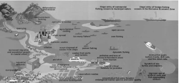
Fig. 2 A chart indicating the relationships of various human-related factors with the marine/coastal environment
7160). But in such cases as when an MPA extends over two or more municipalities, the lack of integrated man-agement usually poses difficulty in the face of the claim for jurisdictional control between two autonomous local government units but having contiguous coastal areas and resources.. Complicating this situation further is the fact that there are some coastal municipal government units sharing a large and contiguous marine resources i.e. bays, gulfs that are linked to the ICM in the area with no approved MPA
A case in point are the two sites of our joint study in the coastal areas of Bicol Region in Southern Luzon which has six officially approved MPAs,; and the three towns in the coastal areas of the Cagayan Valley Region in Northern Luzon which have planned and approved, but not yet implemented MPAs. The delay in the imple-mentation of the approved MPA in the later case of the Cagayan Valley Region may be attributable to the absence of the desire of the constituents for urgent pro-tection of the resources as well as the absence of surveys assessing the degree of deterioration of the coastal envi-ronment. For the purpose of this discussion, we will call the MPAs in preparatory stage in Cagayan “Quasi-MPAs” to distinguish them against the officially approved “MPAs” in Bicol.
Therefore, the differences on the size and estab-lishment process of the MPA, the policies for coastal resource restriction and regulations at the level of aware-ness of the inhabitants to the conservation efforts and mechanisms of MPA management largely influenced by, and depended on the municipality having jurisdic-tion over them But the Philippines’ policies for the community-based coastal resource management, or MPA-oriented resource management which are based on the initiatives of local fisherfolks in the community is a pioneering initiative in ICM in Southeast Asia.
3. Protection of the coastal environment in Southern Luzon
1) MPA of the Bicol Region (A)
Southern Luzon was greatly influenced by Spanish colonial policies, and the effects of the policies can still be strongly felt in the local language (Bicolano) and his-torical relics in this area. In this region, San Miguel Bay and Lagonoy Gulf stretch from north to south, and the Kuroshio Current stems off from Catanduanes Province in the eastern part. From there, the Kuroshio Current flows northward and reaches Kochi Prefecture, Japan. But because the North Equatorial Current joins the Kuroshio Current here, it is almost impossible to clearly
distinguish between the two currents. Because the region is in the tropics, the Kuroshio Current is not widely rec-ognized as a warm current so much as it is in Japan.
In the Bicol Region, fishing intensity is increasing due mainly to the introduction of more efficient fishing gears leading to a decrease in fishery resources and a deterioration of the marine environmental and critical habitats like coral reefs. In response to these, Bicol University played a significant part in terms of doing researches on fisheries and coastal resource management in Lagonoy Gulf since the early 1990s. The university and other government agencies in the region have been conducting continuous investigations and monitoring to determine the changes in the natural and environmental resources and the socioeconomic condition over the years. In addition, the Partido State University, in part-nership with a people’s organization in the region estab-lished an MPA off Atulayan Island in the gulf in order to restore the ecosystem. At the same time, it operated a small-scale resort for tourists in the island to provide alternative source of income to fisherfolks affected by the establishment of the no-take zone in the MPA and lessen the pressure on the coral reef fishery.
In this region, baseline information and studies on the utilization of marine resources and the extent of their conservation are available. By working together with the local research institutes and the NGO, it is thus highly viable and convenient to conduct case studies on the conservation and utilization of natural and environmental resources in this region, which is a typical one of the Kuroshio Current zone.
2) MPA in San Miguel Island
As noted earlier, BU and other organizations con-ducted comparative studies of the coastal environment of Lagonoy Gulf in the past decade (1994-2004). The year-to-year data obtained in these studies are summarized in the report entitled, “Lagonoy Gulf Resource and Socio-Economic Assessment”. The report documented the good condition of the coral reefs adopting a four-point scale (excellent, very good, good and poor) and the man-groves which were also found to be maintained in a rela-tively good condition (Soliman, 1999). The report also noted that while the seaweed and seagrass cover declined a little, there was a slight increase in the population of fishes inhabiting seaweed beds. However, the increase is characterized by juveniles, small and low market value fish species. The increase of juvenile fishes characteristi-cally thriving low on the food chain explains the slight decrease in the seaweed bed biomass. (Fig. 3)
urbaniza-tion of some coastal areas in Lagonoy Gulf provided the incentive and the drive among its residents to innovate more efficient fishing gears. This resulted to the wid-ening economic gaps between small-scale fishermen and large-scale ones who own motorized fishing boats and gears. These developments which fuel fears on the decreasing fish population and productivity in the gulf aroused interest of various sectors in the conservation of the coastal environment. In order to compliment these growing concerns towards sustainable use of marine resources in the gulf, current development initiatives are mainly focused on dynamics of the MPAs established in the gulf area.
An MPA with an area of 225 ha was established in Barangay Sagurong off San Miguel Island, which is located about half an hour from Tabaco by outboard motorboat. In Sagurong, various meetings by villagers were held for about 2 months in 1997 to discuss the problem as to whether an MPA should be established or not. It seems that consensus-building among villagers was difficult because most of them made a living by fishing in the nearby sea. However, an agreement was finally reached that the coral reefs and related resources should be kept in a good condition for future genera-tions. In accordance with the agreement, the city council of Tabaco which has jurisdiction over San Miguel Island waters, held two public hearings and enacted an ordi-nance declaring the site as an MPA to protect the coral reef and the sea grass beds around it. The core part of the MPA occupying 100 hectares was designated as a sanctuary. In this area, the ordinance prohibits any form of fishing activity. Outside this core area is the reserve which serves as a buffer zone to the core part of the
MPA and allows only passive fishing gears or traditional (customary) fishing activities. The decrease of fishing pressure in the MPA has considerably increased the population of fishes to the extent that the incidence of poaching by fishermen from out of the island increased. In response to this illegal form of fishing, civilian law enforcement volunteer groups (BantayDagat) and vil-lage-based peace and order groups (Barangay Tanod) were organized to protect the MPA. A system was created involving the cooperation between these law enforcement groups, village level coastal resource man-agement body and the resource manman-agement committee formed at the city council.
Key informants attested to the fact that the estab-lishment of MPA in the fishing village promoted coop-eration among fishers. However, there were also some observations that the establishment of an MPA increased the incidence of poaching. It has also been observed that since the establishment of the MPA, illegal fishers become more innovative by using finer mesh of nets to catch juvenile fishes. The continued investigation by BU suggests that the establishment of MPA increased fish biomass by about three times and with a little improve-ment on seaweed bed cover.
3) Some social problems arising from MPA
The establishment of an MPA can certainly be rated as a good method for protecting the coastal environment and its ecosystems. But what about the livelihood of fishing-dependent fishers who become displaced from their usual fishing grounds now designated as MPA? Whenever we visited the villages to conduct an investi-gation, we were confronted with the disparity between the theory and practice of MPA-oriented coastal resource management as a developmental intervention as seen on the actual situation of villagers. In Sagulong, San Miguel Island in Bicol region for example, there are about a total of 200 fishing boats in the village with an estimated 600 households. Of this, only about 100 households own fishing boats, while the rest of the households are employed by boat owners to make a living. The average daily household income was about 200 pesos (equivalent to approximately 600yen), and employment from fishing was very unstable because of heavy dependence of fishing operations on weather condition. One of the boat owners in the village had two 16-horse power fishing boats and four hired workers per boat. The employment agreement was mostly verbal and had neither term nor insurance. The economic gap between the boat owner and the employee was evident at a glance. (Fig. 4)
The boat owner mentioned above had served as a
Fig. 3 Changes in habitat, fish and fisher status in Lagonoy Gulf, Albay, from 1994 to 2004
(Source: Seminar materials by V. S. Soliman, 2006)
3-time representative of the MPA’s management com-mittee (term of office: three years) created in the village and is now in the position for the fourth time. Compared with the mid-1990s when the MPA was just established, the majority of the committee’s eight members were now less active. The committee faced confronted with several problems among them are the poor economic incentives for its members as they are mostly on volunteer work with no remuneration; the frequent need to settle vil-lagers resource-use conflict over the MPA; and the slow management action to settle MPA-related disputes as time is needed for the problem to be referred to the city officials.
In response to the displacement of fishers from their usual fishing ground due to the MPA, a fish aggregated device or FADs (Payao) has been installed offshore as a livelihood project. The device acts as a reservoir of fishes established out of the MPA made up of a bamboo float having a rope equipped with an anchor-shaped sinker to which palm branches and leaves are attached. The device uses simple technology out of locally available materials to gather fish and catch them with their fishing gears. It costs 5,000-7,000 pesos a set. The number of fishermen supported by the device is limited, and effec-tive monitoring of the device is difficult because it is established offshore. The device is often lost during typhoon season. To cope with this weakness, some fish-ermen in this village had installed large-scale payaos or FADs patterned after the designs in the Visayas Region near the coastline. While this new development offers an innovation to minimize monitoring costs and damage from typhoons, it has made the protection of marine resources in the inland sea a new policy theme.
Such manifestations and incidences of resource use conflict among stakeholders over the sustainable use of marine resources are widely observed in Japan, too. Although the background of the problems in Japan dif-fers from that of the Philippines, we plan to continue the comparative case study which is currently in progress in Kashiwajima, Kochi in Japan, and in the Philippines. Specifically, we would like to examine how resource-use conflicts are reconciled and what possible conservation outcomes could be achieved in the long run from the establishment of MPA.
4. Protection of the coastal environment in Northern Luzon
1) River Basin and Marine Environment in the Cagayan Valley Region (B)
The Cagayan River (length – 520 km basin area - 27,300 km2), which is bigger than the Shimanto River
(196km, 2,270km2) in Kochi, is found in this region. The
coastal areas in Northern Luzon where the Cagayan river flows into the sea have the Kuroshio Current running in nearby coastal areas and have similar geographical characteristics to Kochi. Recently, the Cagayan Region has quickly been deforested, and due to the resulting soil erosion, masses of soil and sand are flowing into the sea via the river. The northeastern part of Cagayan situated away from the mouth of the river seems to have not been affected by the inflows of soil and sand, and the natural state of the ocean can be observed there. According to the observation by the ecological survey team, the flora of algae in this area partly resembles that in Ishigaki Island,
Japan, and subtropical characteristics can be observed in the area. Cagayan is one region in the Philippines where economic development has been delayed. The BFAR has been working a lot to develop the fisheries and protect rthe marine resources to this province. As far as fisheries are concerned, the province has a good potential both for seaweed farming and inland aquaculture..
In this region, the potential research areas include: comparative study of the Cagayan and Shimanto river basins as they relate to the problems affecting regional development; the possibility of integrating the moun-tains, rivers and the sea as a river basin system; and the relationship between land and coastal areas.
2) “Quasi-MPAs” in the Cagayan Valley Region (B)
In Cagayan Province, three Quasi-MPAs are now established in three towns, namely: Santa Ana, Claveria and Gonzaga. We decided to set up our survey sites in the first two towns. In general, open-access sea areas tend to be devastated by strong impacts of anthropogenic origin, but if left alone and left unattended, these sea areas will be subjected to soil erosion and damage from natural disasters. It seems that activities for the estab-lishment of MPAs in Cagayan placed greater emphasis on coping with the latter problem. The background of the establishment of an MPA in the case of Taggat Norte in Claveria is outlined below.
Presently, 280 households and 1,300 people live in this village and 80% of them live by fishing. In the village, activities for the establishment of an MPA were started in 1994, and preparations for getting an approval were made under the BFAR’s guidance. According to the organizers, the move was regarded as a promising step to promote this remote village, to take advantage of its natural beauty and environment and to invite resort industries to the area. The inhabitants wanted to make the area an MPA in order to realize both the develop-ment of the area for tourism and the protection of its environment. To get official approval, the Provincial Government and the local government of Claveria, together with the two other selected locations: Sta. Ana and Gonzaga, made preparations jointly. The town office of Claveria conducted a simple survey to assess existing resources in cooperation with village officers of Taggat Norte and asked the Department of Agriculture for a judgment through the town office. However, it was determined that the area was not eligible for an MPA mainly because (1) no protected sea area was identi-fied using GIS, etc., (2) the pressure on the marine eco-system in the area was not so heavy as to necessitate the establishment of an MPA, and (3) there is no sufficient
grounds to require the protection of the area.
Although the result was disappointing one, a con-sensus among villagers about the need for an MPA was built in the subsequent meetings, and the village started its own protective measures under the guidance of the BFAR . Patrol groups and law enforcement groups, and committees have been organized, but because the MPA is not an official one, these groups and committees can only warn those committing illegal acts to leave the pro-tected sea area except in the case where unlawful fishing methods are used. The designation of the village as one site for the “Habitat Enhancement & Rehabilitation Program,” which was a separate program, came roughly at the same time and seems to have overlapped with the move to set up an MPA. Because substantial steps have been taken to protect the coastal environment, including among others, the organization of fishermen and the allotment of budget simple FAD or payao was installed instead. Although previously allocated for only 25 house-holds an additional 65 househouse-holds are now included in the waiting list for FAD budget allocation. The develop-ments in Taggat Norte outlined above have spread to the two neighboring villages, where activities are now being carried out for the organization of fishermen and coop-eration with Taggat Norte.
Conclusion
In Japan, people in the Edo period (1603-1867) used to call the Kuroshio Current, which runs northward off Kochi, the “Kurose River.” If we compare this cur-rent to a river, the Philippines is situated in the upstream, Taiwan, in the midstream and Japan, in the downstream. What occurs in the upper stream will directly spread downstream sooner or later. According to the annual investigation on the offshore areas of Kochi, the temper-ature of seawater on the surface has risen by nearly 2°C in the past three decades, as a result of which the sea off Kochi is changing into an environment where subtropical and tropical algae and fishes can winter and survive even in winter. In fact, the area occupied by tropical and sub-tropical algae is rapidly increasing in this part of the sea instead of temperate ones. The view that isoyake (seaweed withering), an indicator of the retreat of seaweed beds, is caused mainly by the eating of algae by foreign fishes is becoming an established theory.
In order to address these problems, which are taking place across national borders, we are conducting on-going investigations. Based on these investigations, and using case studies in the Philippines as example, this paper reports on recent policies for the ocean
envi-ronment, and inhabitants’ activities for conserving the coastal environment. (Fig. 5) The initial results of these investigations suggest the following facts:
First, in the Philippines, as a result of the rapid and localized urbanization triggered by the country’s eco-nomic growth, the environmental pressures on rivers and coastal areas has been increasing. Moreover, the fishing intensity is great due to alleged excessive fishing. Aware of these problems, the government has been working hard to conserve the marine resources and to protect the coastal environment. MPAs are established in the coastal areas and have gradually increased equivalent to one-sixth of the country’s coasts. At present, various legal systems and promotional measures are being pre-pared to encourage the integrated coastal management of politically autonomous LGUs in a physically contiguous and interconnected marine.
The second issue is the harmonization of social concerns and policies vis-à-vis the noble objectives of environmental protection. The coastal environment is an open-access resource which can be used by everyone as much as they like, and is thus prone to destruction by excessive use. In addition, if left unattended for too long, it can easily deteriorate from soil erosion and land-slides caused by flood, water run off and calamities. It may be considered that the former is the situation seen in southern Luzon and the latter, in northern Luzon. To utilize these resources in a sustainable manner, there is a need for a social system that constantly monitors the state of the resources and capacitated to implement pro-grams that will prevent their devastation. The MPA in the Philippines can be regarded as a concrete example of such a system. However, considering the economic situation of inhabitants, there are big challenges that lie
ahead particularly on the establishment and management of MPAs. How will these problems in the coastal areas be solved in the municipal level in the future? This is considered to be a fundamental question that will have direct effect on the future developments of MPAs.
Finally, there is the concept of “commons,” the idea attracting attention recently, as a possible mechanism for managing those natural resources, as represented by marine resources, which, if left alone, would deteriorate and be devastated due to intensified utilization. Known as the “tragedy of commons” advocated by G. Hardin, this concept is now refuted by many people (Hardin 1968). The counterarguments are based on the theory that the joint use of resources is not equivalent to open access; they argue that because these resources have a community that act as the owner of the resources, the community will control their use and thus, the sustain-able use of the resources is often possible, cases of which can be found all over the world. Studies on the conser-vation and sustainable use of various natural resources that builds up from the idea of the commons to develop a mechanism for community-based resource management are recently increasing. Given the experiences of MPAs being promoted in the Philippines as one of the entry points and mechanisms to deal with the commons and thus promote sustainable resource use on a co-manage-ment context, it is our plan to continue our observation of the social, cultural and biophysical dynamics of selected MPAs in the coming years. .
The many potentials of MPAs towards addressing global-scale environmental issues and promoting rational use of marine resources have their own limits as its mea-sures only apply on a regional level. There is however the possibility that these potentials of the MPA regime may hold the key towards addressing the common prob-lems facing Japan, Taiwan and the Philippine coastal waters. An oceanographer said, “When the number of
fishes decreases, a strange situation arises: those who don’t know the past come to think that the present situ-ation is a normal one [even if it is actually abnormal].”
What is certain is that periodic comparison between adjacent regions and adjacent countries will become more and more important in the future in order to know the problems about the sea arising across national bound-aries.
References
Bradecina, R. G. Morooka, Y. and Shimob, T. 2006. Assessing behavioral aspects of coastal and fishery resource use in Taggat Norte, Claveria,
Fig. 5 Drying of seaweed (Euchema) harvested at Rapu-rapu Island in Lagonoy Gulf, Albay (2007)
Cagayan, Philippines. A Joint Survey Report (unpublished), GSKS, Kochi university. Pp.1-13. Hardin, G. 1968. The Tragedy of the Commons, Science,
162, pp.1243-1248.
Silvestre, G, C. Luna, V. Soliman and L. Garces (eds). 1995. Resource and Ecological Assessment of Lagonoy Gulf. ICLARM Technical Report. Soliman, V. S., 1999, San Miguel Marine Fishery
Reserve Project in Tabaco, Albay: Lessons Learned. R. and D. Journal XII. Pp.98-102. Soliman, V.S., R.R. Dioneda, Sr., and N.R. Pelea (eds).
2005. Lagonoy Gulf Post-Resource and
Socio-economic Assessment. Final Report Submitted to the Fishery Resource Management Project, Department of Agriculture-Bureau of Fisheries and Aquatic Resources, Quezon Avenue, Quezon City. Bicol Small Business Institute Foundation, Inc., Bicol University Main Campus, Legazpi City. 306 pp.
White, A. T., Eisma-Osorio, R. L., and Green, S. J. 2005. Integrated Coastal Management and Marine Protected Areas: Complementarity in the Philippines Ocean and Coastal Management. 48. pp.948-971.