1
Component Part No. 5-1 of the “Sites of Japan’s Meiji Industrial Revolution”
Conservation, Restoration, Presentation and Public Utilization Plan
for Mietsu Naval Dock
(Area 5 Saga)(Abstract)
Saga City drew up a Conservation, Restoration, Presentation and Public Utilization Plan for Mietsu Naval Dock (hereinafter referred to as “Plan”) in FY 2016 and 2017, which became a source of “Conservation Work Programme” pursuant to Recommendation b) in Decision: 39 COM 8B. 14 as adopted by the World Heritage Committee at its 39th session in 2015, The Plan comprises detailed measures for the conservation, restoration, presentation and public utilization of the component part of the “Sites of Japan’s Meiji Industrial Revolution: Iron and Steel, Shipbuilding and Coal Mining” (hereinafter referred to as “Sites of Japan’s Meiji Industrial Revolution”). This document provides an abstract of the Plan.
1. Vision
By making the “unseen Mietsu” visible, the idea is to show the world how the Saga Clan in the last years of Edo Period modernized through trial and error. To this end, the city is carrying out projects to conserve, restore, present and make public the component part, maintaining its value and conveying that value clearly to visitors, while paying attention to the nature of buried archaeological remains.
Mietsu Naval Dock of Area 5 Saga is a set of archeological remains providing evidence of efforts by the Saga Clan to obtain technology related to Western-style ships, through trial and error, technology improvement and diffusion, and human resource development, from the last years of Edo Period to the early Meiji Era. It qualifies as a component part contributing to the Outstanding Universal Value of the Sites of Japan’s Meiji Industrial Revolution in that it demonstrates how, in the process of Japan’s modernization, Western technology was aggressively introduced and transferred, and was merged with Japan’s existing technology.
Crucial to an accurate understanding of the value and role of Mietsu Naval Dock is an adequate grasp of the long history and traces of activities, focusing on the period while the naval dock was active, but extending the interest from the time before the dock was established all the way to the present day. This history includes the period of the Saga Maritime Academy from the late Meiji to early Showa Era, after the naval dock was closed. In conservation, restoration, presentation and public utilization of Mietsu Naval Dock, the process of historical changes and developments of the component part will therefore be kept in mind at all times.
(1) The advantages and disadvantages of being “unseen” There are many constituent elements clearly showing the nature of the component part, including the underground archaeological remains of the dry dock and of metal works section at Mietsu Naval Dock. At the same time, however, they
Conservation, Restoration, Presentation and Public Utilization Plan for Mietsu Naval Dock (Abstract)
2 are covered by protective layers.
For preservation of the archaeological remains, being buried in the ground is the optimal environment. Keeping this “unseen” state, in other words, is considered as of the utmost necessity for the long-term preservation of the archaeological remains.
From the standpoint of efforts to convey the value of these remains, however, maintaining this optimal environment for preservation has the disadvantage of making it difficult to show them directly to visitors. (2) Conveying what is “unseen”
Efforts to overcome the disadvantages for public showing while retaining the advantages of the preservation environment can be thought of as equivalent to the process of solving the issues stemming from the nature of the Mietsu Naval Dock archaeological remains. It is necessary to recognize once again the many different causes of being “unseen,” such as not physically existing, being buried underground so not visible, being visible but not noticed, or not being noticeable without obtaining information. Moreover, it is important to give careful explanations, including these various causes and reasons, and to provide the basic information for properly understanding the underground archaeological remains. It will be essential also to devise effective means of “visualizing” the remains so they stick in the mind of visitors, from the standpoints of both the landscape at the time as seen from the underground remains and the way the land has been used passed on to today, such as rivers, fishing ports, and nearby villages.
To these ends, the city, rather than relying solely on above-ground displays of the underground archaeological remains, will make use of value-conveying means incorporating a wide range of technologies and methods, from the latest digital technologies including virtual reality and augmented reality to such analog approaches as having human guides directly talk to visitors. Additionally, even if the underground remains cannot be seen directly, visitors will be presented with an image of the facilities and their operations at the time the naval dock was in use, by skillfully combining exhibits on the remains with exhibits in the facilities for public utilization and promotion.
(3) Communicating the significance will make people get involved
Sustainable measures adopting diverse methods are needed for ensuring the component part is passed on to the next generation. The city will therefore create an environment, using various means, enabling people to obtain an accurate understanding of the heritage value and themselves take part in actions for protecting and conveying that value. The city will also go ahead with measures for conservation, restoration, presentation and public utilization of the component part so that the attachment to the heritage resulting from these efforts may help foster pride amongst the local residents.
2. Policy
The policy for conservation, restoration, presentation and public utilization of Mietsu Naval Dock is set based on the six items below.
(1) Conducting investigative studies
The city will continue carrying out excavation surveys and historical document surveys to accumulate basic information for the presentation, public utilization and promotion measures aimed at protecting and conveying the value of the heritage and making it a core of the local community. The city will also conduct investigative studies in such areas as visitor behavior analysis, enhancement of monitoring, and methods of exhibiting and presenting the component part to the public.
(2) Enhancing preservation of constituent elements
3
and will carry out restoration work if damage is found in the superstructures or terrain. If new excavation surveys are conducted, adequate
measures will be taken to preserve the underground remains when reburying them.
Trees or other plantings that may damage the underground remains will as a rule be removed.
In case of a disaster, after promptly confirming the situation and taking necessary emergency measures, restoration measures will be taken for preservation of the component part.
As one measure, the existing parking facilities in the component part will be transferred off site to enhance protection of the underground remains.
(3) Presenting and explaining systems for shipbuilding and ship-repair
The city plans to avoid exposing the underground remains for viewing, instead choosing to provide information that treats the exhibits immediately on the
underground remains and the exhibits in public utilization and promotion facilities as an inseparable, integrated exhibit. Even though the buried remains cannot be seen directly, new methods such as digital technology, and guides who can meet visitor needs effectively, will be employed to enable visitors to visualize the facilities and operations during the period when the naval dock was in use. At the same time, the historical background and flow, and other aspects of the total picture, will be exhibited and explained in readily understood ways.
(4) Arranging and improving landscape from the standpoint of scenic view
The city, while performing appropriate maintenance, will endeavor to maintain the present state of the superstructures, and the topography of the inlet, etc., which have kept most of their shape since the period when the Mietsu Naval Dock was in operation. As for objects that did not exist when the Mietsu Naval Dock was in operation and that obstruct the landscape, these will be removed, moved, or have their appearance improved. In the case, however, of trees, grass and other plantings, so long as they are not likely to damage the underground remains, their current state will be maintained to keep their relaxing function for visitors. Trash and other objects that drift onto the site will be properly removed, endeavoring to maintain the good appearance of the component part and the surroundings.
(5) Utilizing the Naval Dock as cultural resource and for information dissemination in the Area Making use of diverse effective information dissemination, the city will create opportunities for visiting, and convey the value and significance of the component part by various means to deepen their understanding. The city will further provide venues enabling those who come to understand the value of the component part to voluntarily become involved in preservation and promotion initiatives. As noted earlier, Mietsu Naval Dock cannot be shown directly, since the archaeological remains should buried underground and there are restrictions on how much the terrain can be modified. People from various fields, under official direction, will cooperate in efforts to overcome these disadvantages for conserving and promoting the site.
(6) Implementing projects
The Mietsu World Heritage Division of Saga City will carry out the projects prescribed in this Plan according to a schedule divided into Short Term, Medium Term and Long Term periods, working closely with other related city divisions including the Cultural Promotion Division, the Government of
4
Japan, Saga and Fukuoka Prefectural Governments and other authorities and with local residents. The Short Term period will be five years starting in FY 2017. The Medium Term period will be the next five years, followed by the Long Term period.
3. Methods
(1) Conducting investigative studies
(a) Excavation surveys and historical document surveys
The city will conduct excavation surveys to determine the structural features of the shipbuilding and ship-repair facilities and how the spaces were used. The surveys will be limited to the minimum extent needed for gathering information to be used in on-site presentation, public utilization and promotion, with all due care taken not to damage the underground archaeological remains in the excavation process. Historical document surveys will be conducted to gather information about the process of building Mietsu Naval Dock, transformation of the Saga
Clan navy, steamship repair and building, the role of the naval dock in the last years of Edo Period. Japan, technology exchanges with Nagasaki, the people involved in building the naval dock, and the human resources it produced. The historical document surveys will go along with progress in the excavation surveys.
(b) Survey and analysis of visitor behavior
The city will conduct surveys of visitor behavior and awareness, and analyze the results. The surveys will cover such matters as where the visitors came from, their age group, motivation for coming and means of travel, and their satisfaction with the exhibits and staff. The survey results will be used to improve the project.
(c) Enhancement of monitoring
The city will study highly durable materials for on-site presentation of the underground archaeological remains on the surface of the ground, methods for protecting the underground remains from soil pressure, and methods necessary for enhancing protection of the remains. The results of these studies will be reflected in methods of on-site presentation, public utilization and promotion inside the component part. Monitoring charts will be created for comprehensively and systematically bringing together information on constituent elements. These will be used for periodic monitoring of the state of and changes to the component part and the buffer zone through observations over time. Regular monitoring of the underground water levels and quality (dissolved oxygen, etc.), necessary for determining the preservation state of underground wooden structures will be carried out as needed at the future stage of site conservation, restoration, presentation and public utilization, based on sufficient studies of effective and efficient methods.
(d) Investigative studies on exhibiting, on-site presentation and public utilization methods
The city will conduct a broad range of studies, not limited to conventional approaches, on effective means for information provision using digital technology, both in outdoor exhibits in the component part and in indoor exhibits in the facilities for public utilization and promotion.
(2) Enhancing preservation of constituent elements
5
(a) Maintenance, conservation and restoration of constituent elements
The underground archaeological remains need to be preserved in their buried state and continually maintained in good condition. The city will periodically observe the remains looking for changes in the shape of the soil surface such as unevenness or subsidence, and will assess the state of protective layer covering the remains. In case adverse impact on the underground remains is foreseen, an excavation survey will be considered for checking the situation. Fragile objects of wood or metal unearthed in the excavation process will be properly preserved as the situation warrants.
The city will continue endeavoring to maintain in stable condition terrain left over from when Mietsu Naval Dock was in operation, and will make use of monitoring charts to visually keep track of changes in the shape of the soil surface. If extensive damage is confirmed as in a disaster, the city will restore the part in question using the same materials as before the damage, in consultation with the Chikugo River Office in the Kyushu Regional Development Bureau of the Ministry of Land, Infrastructure, Transport and Tourism (MLIT) in charge of river management, the Saga City Southern Area Construction Office responsible for parks management, the Saga City Fisheries Promotion Division managing fishing ports, and other organizations.
(b) Moving of parking facilities
For the sake of stably maintaining the underground archaeological remains, the city will move the present parking lot to a location outside the component part, to reduce compacting of the soil by vehicles and to make the scenery more suitable to the historical heritage site.
(3) Presenting and explaining the systems for shipbuilding and ship-repair
The component part will be divided into three Zones based on how the naval dock was used: the Shipyard Zone, Training Institute Zone, and Ship-Repair Dock Zone. The Buffer Zone will be divided into an Agricultural Land Zone, River Zone, and Village Zone for the purpose of maintaining the landscape and land use. In addition to these Zones, a Guidance Zone will be established in the northern part of the Buffer Zone, as an area of the facilities for public utilization and promotion of the Component Part and for providing facilities for the convenience of visitors.
The city will implement each of the following based on the above zoning plan.
Figure 5: Zoning plan for Mietsu Naval Dock
6 (a) Setting visitors flow lines
To provide clear explanations of the value of Mietsu Naval Dock and the shipbuilding and ship-repair systems, and to enable handling large numbers of visitors, visitors flow lines will be set from the Guidance Zone parking lot to the indoor exhibits in the public utilization and promotion facilities, and from there to each of the outdoor exhibits in the Shipyard Zone, Training Institute Zone, and Ship-Repair Dock Zone inside the component part.
(b) Modifying Terrain
The existing topography of the riverbed will be retained, without land filling or other terrain modification.
(c) Presenting above-ground displays indicating buried remains
Two-dimensional and three-dimensional displays above the ground’s surface will indicate the locations and scale of the remains of metalworking remains, earthen embankments, wooden piles, and other underground archaeological remains. Concerning the display of the dry dock remains, detailed examination will be performed, based on the idea of having two-dimentional and three-dimentional displays. For aspects that are difficult to show, such as the actual three-dimensional appearance of the remains and the roles of each of the remains in the shipbuilding and ship-repair systems, digital technologies such as augmented reality and virtual reality will be used to present images on tablets or other information devices.
(d) Arranging and improving landscape and planting vegetation
Arranging and improving landscape and planting vegetation inside and around the component part will be carried out so as not to obstruct the image of the operating naval dock, with its flat work spaces. Plantings that are the cause of such obstruction will therefore be removed or trimmed. While no new planting is planned, trees not likely to adversely damage the underground remains or obstruct the image of the operating naval dock will be retained as much as possible, to provide shade and resting places to visitors.
(e) Installing guidance and explanatory boards
The contents of the guidance and explanatory boards will be readily understandable by anyone at any time. The boards newly installed in and around the component part will have a simple, uniform shape and design in harmony with the landscape. Digital technology will also be used, conveying information smoothly to a varied audience by means of caption and voice, and in multiple languages. (f) Installing administrative and utility facilities
The parking lot inside the component part will be removed, to be replaced with a parking area in the new Guidance Zone with an appropriate number of parking spaces. Protective fences will be installed on the riverbanks near the component part to prevent falling, and nets or the like will be used to keep out drifting objects during high tides. If toilets need to be upgraded or moved, the location will be considered consulting with concerned parties, including the option of moving them outside the component part. Additionally, utility facilities in the park will as a rule be upgraded selecting suitable locations. Simple shapes and designs will be used, in harmony with the landscape inside the component part. They should not be wrongly identified as the “outdoor exhibits” of the underground archaeological remains displayed on the surface of the earth layer covering underground archaeological remains.
(g) Installing facilities for public utilization and promotion
7
understanding of the overall picture of the World Heritage “Sites of Japan’s Meiji Industrial Revolution,” the positioning of the Mietsu Naval Dock among the 23 component parts, and its role among the industrialization projects by the Saga Clan in the last years of Edo Period.
(4) Arranging and improving landscape from the standpoint of scenic view (a) Arranging and improving landscape inside the component part
The city will move, remove, or upgrade the facilities deemed not suitable for location inside the component part, such as the parking lot and the above-ground display facilities based on drawings from the Taisho Era (1912-1926). The habitat of the reed beds along the river, reminiscent of the waterside landscape when Mietsu Naval Dock was in operation, will be maintained while keeping down overgrowth. Trees will be removed if they threaten the underground remains, while those trees that function as scenic beauty and shade along the riverbank will be kept, and grass will be planted in open areas. Trash and other objects that drift onto the site will be properly removed, to maintain the good appearance of the component part and surroundings.
(b) Arranging and improving landscape of the buffer zone
The terrain and land usage of the Agricultural Land Zone, River Zone, and Village Zone in the buffer zone have been largely retained from the time Mietsu Naval Dock was in operation, and will continue to be maintained by Saga City and Okawa City (Fukuoka Prefecture) in accordance with the applicable laws, including the Act Concerning Establishment of Agricultural Promotion Areas and the Landscape Act. A viewing point will be established on the third-story terrace of the Tsunetami Sano Memorial Museum that exists in the Guidance Zone, with an overall view, enabling visitors to imagine the environment around the naval dock when it was in operation.
(5) Utilizing the Mietsu Naval Dock as cultural resource and for information dissemination in the Area
The city will use various methods to continue disseminating accurate and specific information, while conducting visitor behavior surveys, studies for providing new academic information, and research on effective information dissemination methods. Visitors will vary in age and place of origin, from children to adults, and from local residents to people from other areas. All due care will be taken to combine various methods of information dissemination, holding events and lectures to attract visitors, and providing tourism programs tied in with local resources of the surrounding areas. By means of integrated indoor and outdoor exhibits using mainly digital technology and exhibition of real objects and replicas for sensory experience, along with enhanced guide functions, visitors will be provided with explanations of the Outstanding Universal Value of the World Heritage property as a whole and positioning of Mietsu Naval Dock in that. Moreover, by making local residents aware of the significance of Mietsu Naval Dock as something they themselves can be proud of, protect, and tell others about, the city will endeavor to create venues for them to participate voluntarily as guides or in beautification and other activities, and will support them in such activities.
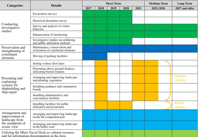
4. Projects implementation
(1) Order of priorities
The city has set projects implementation periods starting from 2017, consisting of a Short Term period of five years, a Medium Term period lasting the next five years, and a Long Term period following thereafter.
8
exhibits, including displays of the underground remains within the component part.
In the Medium Term period, the progress of projects in the Short Term will be checked, and the work on outdoor exhibits in the component part started in the Short Term period will be completed.
In the Long Term period, visitor surveys and monitoring will be continued along with maintenance and conservation of the constituent elements, and arranging and improving landscape inside and outside the component part. Activities tied to related modern-era remains will also be carried out.
The following items will be carried out with high priority.
Academic information will be collected, and excavation and historical document surveys will be continued to further the value.
The parking lot inside the component part will be removed, and replaced with a new parking area in the Guidance Zone.
The public utilization and promotion facilities will be established, and after completion of excavation surveys in the component part, outdoor exhibits, including displays of the underground remains on the surface of the earth layer, will be finished.
(2) Review of implementation schedule
Around 2026, the final year of the Medium Term period, a thorough review will be made of the projects conducted in the Short Term and Medium Term periods, and if issues needing remediation are found, the schedule will be revised.
(3) Other
The city has carried out conservation and restoration work, etc. for the Mietsu Naval Dock by securing necessary funds* making use of various subsidy programs available in FY2016 and FY2017, the first two years following inscription of the property on the World Heritage List. To ensure the smooth implementation of the project, it plans to continue such efforts to secure necessary funds in partnership with relevant institutions.
9
Categories Details Short Term Medium Term Long Term
2017 2018 2019 2020 2021 2022-2026 2027 and after
Conducting investigative studies
Excavation surveys
Historical document survey
Survey and analysis of visitor behavior
Enhancement of monitoring
Investigative studies on exhibiting and public utilization methods
Preservation and strengthening of constituent elements
Maintenance, conservation and restoration of constituent elements
Moving of parking facilities
Presenting and explaining systems for shipbuilding and ship-repair
Setting visitors flow lines
Presenting above-ground displays indicating buried remains
Arranging and improving landscape and planting vegetation
Outdoor exhibits
Installing guidance and explanatory boards
Installing administrative and convenience facilities
Installing facilities for public utilization and promotion
Indoor exhibits
Arrangement and improvement of landscape from the standpoint of scenic view
Arranging and improving landscape inside the component part
Arranging and improving landscape in the buffer zone
Utilizing the Miets Naval Dock as cultural resource and for information dissemination in the Area
10