HOLTON, Gary, 2017. ‘A unified system of spatial orientation in the Austronesian and
non-Austronesian languages of Halmahera’. In Antoinette SCHAPPER, ed., Contact and GaryHOLTON
University of Hawai‘i at Mānoa
The Austronesian and non-Austronesian languages of Halmahera Island and vicinity share a system of absolute spatial orientation in which the up-down axis is oriented horizontally along the coast. The systems in the individual languages have converged so that it is possible to speak of a single Halmaheran system of orientation whose spatial semantics are independent of language. However, the factors determining the orientation of the upcoast-downcoast axis—which way is up and which is down—have remained elusive. Drawing on a comprehensive survey of the orientation of the upcoast-downcoast axis in Halmahera, we propose an account of orientation in Halmahera which unites both coastal and riverine uses of the up-down axis. We suggest that the orientation of the upcoast direction toward the interior of bays derives from its origin as an upstream directional. An originally non-Austronesian system of riverine orientation has diffused into the non-Austronesian languages and been adapted to form a pan-Halmaheran directional system.
1. Spatial orientation in Halmahera1
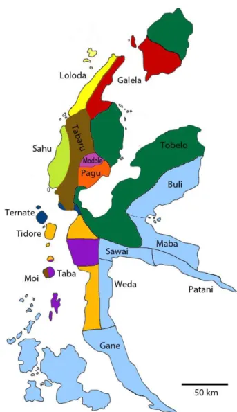
The island of Halmahera, in North Maluku province, Indonesia, is home to two distinct language families, North Halmaheran (NH) and South Halmaheran (SH). The former is a closely related group of Papuan (non-Austronesian) languages which may in turn be related to several West New Guinea languages spoken on the Bird’s Head of New Guinea (Holton & Klamer 2017, Voorhoeve 1988). The latter group is part of the South Halmahera-West New Guinea group of Austronesian languages, which are classified as a group coordinate with the Oceanic branch of the Austronesian family (Blust 1978). The influence of the Papuan NH languages on the Austronesian SH languages is described in Voorhoeve (1994), and the influence in the reverse direction is evidenced by numerous Papuan loans, such as Weda (SH) bifi ‘ant’ < Ternate (NH) and Taba (SH) fati ‘cover’ < Tidore (NH). However, the most striking feature which is shared across all of the languages, both Papuan and Austronesian, is a system of orientation which contrasts a seaward-landward axis with an orthogonal upcoast-downcoast axis. In this paper I use the uppercase abbreviations SEA, LAND, UP, DOWN to denote the grammaticized directionals corresponding to seaward, landward, upcoast, downcoast, respectively. The UP and DOWN terms are generally polysemous, each having both a horizontal and vertical interpretation. However, in the languages of Halmahera the default meaning of UP and DOWN is horizontal along the coast.
1 I am grateful to the many dozens of people in Halmahera who have assisted with this research by freely
Figure 1: Approximate language boundaries within Halmahera and environs. Blue shading represents Austronesian languages; other colors represent
non-Austronesian languages.
Knowing the local orientation of directionals is a constant challenge for Halmahera residents, but it is one which is met easily without any apparent difficulty or conscious effort. This paper focuses on the use of directionals at what I call the geographic scale, equivalent to what Teljeur (1987:348) calls the village scale and Bowden (1997:256) calls the intermediate scale. However, the system is used constantly at smaller interactional scales as well, to indicate locations of objects on a table or positions in a vehicle, for example. Halmahera residents routinely make use of absolute directionals in contexts in which speakers of other languages would use relative terms ‘left’ and ‘right’. The absolute frame of spatial reference is preferred over intrinsic or relative frames in almost all contexts.2
2 An intrinsic frame of reference relies on intrinsic properties of the reference object, e.g., ‘at the front of
1.1. Consistency across languages
One of the most striking features of spatial orientation in Halmahera is the consistency of directional usage across languages, from the North Halmaheran (non-Austronesian) family to the South Halmaheran (Austronesian) family to the local Malay vernacular, North Moluccan Malay (NMM). So salient is this orientation system that the Halmahera usage even finds its way into what might otherwise be considered standard Indonesian. One simply cannot function in Halmahera without understanding the directional system. This observation is not new. Taylor characterizes the “distinctive treatment of spatial deixis in North Moluccan Malay [as] one of the most initially striking features of the dialect” (1983:17). Bowden observes that the directional system was “one of the most puzzling aspects” of the Taba language for a learner (1997:251). Indonesian visitors from outside Maluku report similar problems. The classic example is that of a visitor to Ternate who upon arriving at the airport is told that the town of Ternate lies ka bawa, literally ‘downward’ and then assumes that the speaker must be referring to a direction down the slope toward the water. In fact, in NMM as in the indigenous languages of Halmahera, UP and DOWN refer to directions parallel to the coast. On the island of Ternate DOWN corresponds with clockwise, which in Ternate town on the southeast side of the island is roughly south and certainly not toward the water. Discussions of cross-cultural communication involving the failure of outsiders to understand NMM directionals provide an endless source of entertainment for Halmahera residents.
Perhaps the most striking aspect of the directional system in Halmahera, next to its pervasiveness, is that the usage of the system is almost entirely consistent across languages. At any given location the UP, DOWN, LAND, and SEA directions remain the same regardless of what language is being used. Though some conventionalized uses of directionals may differ across languages, the orientation at a given point on the landscape is independent of which language is being used. This is perhaps not surprising for the seaward and landward directions, which generally have clear topographic motivations, but it is remarkable for the upcoast and downcoast directions, where there appear to be no geographic cues as to which direction along the coast is UP. This is significant given the multilingual nature of the region. For example, in the village of Jailolo on the west coast of Halmahera at least three languages are widely spoken: Ternate, Sahu, and Malay. In this region the UP direction is oriented to the left along the coast when facing the water, and UP can be expressed as Ternate daku, Sahu da’u, or Malay atas. Halmahera directionals belong to the landscape, not to the language or the people.
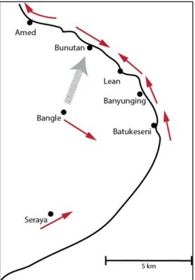
Figure 2. Small arrows indicate orientation of the kangin direction on the east coast of Bali (after Wassmann & Dasen 1998:698). Large dashed arrow indicates
migration from Bangle to Bunutan village.
On the south coast of the island kangin is to the left along the coast when facing the water, while on the north coast kangin is to the right. Along the east coast there is a mismatch. In most of the villages kangin points to the left when facing the coast, i.e., anticlockwise, but in Bunutan kangin points to the right (see Figure 2).
The mismatch between Bunutan and the other coastal villages can be readily explained through recent migration history. Most of the villages on the east coast were settled from Seraya and thus use an orientation system in which kangin points to the left when facing the coast, as found on the south coast of the island. But the village of Bunutan was settled from the mountain village of Bangle and has imported the Bangle system via a direct geometric translation so that kangin remains ‘East’ and hence to the right when facing the coast in Bunutan. The residents of Bunutan apparently retain their original directional associations as used in Bangle—perhaps associating kangin with the direction of sunrise—while ignoring local usage along the coast by their immediate neighbours. Such a mismatch would be unthinkable in Halmahera, where migrants strive to understand local usage rather than impose a system based on a different location. The power of these local associations of directional orientation is so strong that even migrants from outside Halmahera adopt the local horizontal uses of ‘up’ and ‘down’ into their own languages.
paper when I speak of the orientation of particular direction, i.e., which way is UP, it should be assumed that this orientation is independent of language choice.
1.2. Frames of reference
1.3. Structural properties of directionals in Halmahera
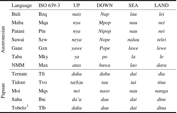
The morphology and syntax of orientation systems in Halmahera has been reviewed in detail in a survey by Yoshida (1980), so I will only provide a brief overview here. The precise form of the directional morpheme varies by word class, but the directionals can be illustrated by the forms in Table 1 below.
Table 1. Directional roots in the languages of Halmahera
Language ISO 639-3 UP DOWN SEA LAND
A
us
tr
one
si
an
Buli Bzq nais Nap lau lei
Maba Mqa nya Mpop nau nei
Patani Ptn nya Nipop nau nei
Sawai Szw neya Nope nalau telei
Gane Gzn yawe Pope lawe lewe
Taba Mky ya po la le
NMM Max atas bawa lao dara
P
ap
u
an
Ternate Tft daku dahu dai dia
Tidore Tvo ta(h)u tau tai tina
Moi Mqs nei naso nau nanga
Sahu Ibu da’u dau dai dine
Tobelo3 Tlb daku dau dai dina
The forms of the directionals are clearly cognate across the Austronesian languages, as well as across all of the Papuan languages with the exception of Moi. The latter appears to have borrowed from an Austronesian language, though curiously, probably not from its neighbor Taba on Makian Island.
The full directional system in the Papuan languages is actually more complex than indicated in Table 1. Although the current paper focuses on the orthogonal UP-DOWN and SEA-LAND axes, in the NH languages these four directional terms are embedded in a larger demonstrative system. For example, in addition to the four directional terms the Tobelo system also includes a proximal demonstrative and two distal demonstratives. The punctual terms nena ‘this’ and gena ‘that’ function as general demonstratives. The second proximal term dokena differs in that it makes explicit reference to the directional system; however, rather than indicating one of the directions UP, DOWN, SEA, LAND dokena indicates that the referent is “not in the upward-downward or landward-seaward axis, thus either in an unknown direction, or in a direction falling in between those other generally perpendicular axes, or across some obstacle such as a river or mountain” (Taylor 1984:112).
3 Tobelo is here taken to be representative of the language complex denoted Northeast Halmaheran by
Moreover, in the NH languages the directional system permeates several areas of the grammar. The land-sea and up-down oppositions can be found reflected in nominal and verbs affixes, adverbs, demonstratives, and motion verbs. The basic directional system in NH languages thus forms what Burenhult and Levinson (2008) characterize as a
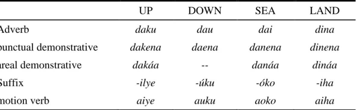
SEMPLATE, a conceptual framework which is realized across several domains of grammar. Moreover, the land-sea and up-down dimensions are generally just one subset of a larger system of directional terms which may include distal, proximal, allative, and ablative terms as well. These complexities can be illustrated by Tobelo, which in addition to directional adverbs also has a punctual and areal demonstrative pronouns, as well as directional suffixes and directional motion verbs derived with those suffixes. Table 2. Tobelo directional terms across a range of syntactic domains (Holton 2003)
UP DOWN SEA LAND
Adverb daku dau dai dina
punctual demonstrative dakena daena danena dinena
areal demonstrative dakáa -- danáa dináa
Suffix -ilye -úku -óko -iha
motion verb aiye auku aoko aiha
There may be distributional restrictions across the various directional domains. For example, directional demonstratives, but not directional adverbs, may serve as the head of an attributive construction in Tobelo. Directional usage is exemplified below.
(1) Tobelo, NH (Holton 2003:51) danena ma-paitua
PUNCT.SEA RNM-older.man
‘that older man in a seaward location’
These various paradigms can be combined to create morphologically complex directional expressions. In Tobelo two directional morphemes can be linked via a verbalizing morpheme to indicate movement from a location specified by the first term to a direction specified by the second term. Thus in the following example the complex form dau-k-iha denotes movement from a location DOWN the coast from the deictic center in a LAND direction.
(2) Tobelo, NH (Holton 2003:51)
Dau-k-iha yo-wohama-iha ya-tuhuku.
DOWN-V-LAND 3PL-enter-LAND 3PL.3-shoot
‘They landed at a location down the coast, going inland, shooting.’
Directional demonstratives occurring as free morphemes may be used in combination with directional suffixes, as in the following example.
(3) Tobelo, NH (Holton 2003:51)
I-mi-tururu dakena ma-dobiki-ilye. 3-1EXC-move UP.PUNCT RNM-little.bit-UP
Directional suffixes may affix to both nouns and verbs, even on both nouns and verbs in the same clause.
(4) Galela, NH (Sheldon 1991:156)
To-majobo-ku dahu o-lapangan-ku. 1SG-depart-DOWN DOWN NM-field-DOWN ‘I left down to the air strip.’
Many of the SH languages have motion verbs corresponding to the sea-land and up-down directions (see example (8) below). These verbs collapse the oppositions along each axis and instead focus on the distinction between the two axes.
Combinations of directional terms can be used to express complex deictic relations. For example, in Tidore directional roots can be used recursively, so that the first of two directionals expresses the relationship between the ground and some intermediate referent and the second directional expresses the relationship between the figure object and that intermediate referent. Thus, isa-tai expresses a location which is first to the landward side of the speaker and then slightly toward the opposite seaward direction. This is then interpreted to mean the opposite side of a wall.
(5) Tidore, NH (van Staden 2000:111) Gure ena isa-tai.
put 3S.NHUM LAND-SEA
‘Put (hang) it on other the side of the wall.’
The Austronesian languages also include proximal and distal demonstratives as part of the directional system, but their structure is less elaborated than that found in the non-Austronesian languages. Taba distinguishes locative, allative, and venitive forms of each of the directionals. Prefixes on directional forms indicate motion toward or away from a given direction.
(6) Taba, SH (Bowden 2005a:149) Galas lewe meja li. glass LAND.LOC table LOC
‘The glass is in a landward direction on the table.’ (7) Taba, SH (Bowden 1997:251)
L-han appo Gitan. 3PL.go DOWN.ALL G.
‘They went down to Gitan.’
The SH languages Buli, Maba, and Patani also make use of directional verbs which indicate motion along the UP-DOWN or SEA-LAND axes without respect to orientation along those axes.
(8) Patani, SH (Holton, field notes)
Yama to.
go.UP.DOWN already
‘Go already (in a direction parallel to the coast).’
2002), and North Moluccan Malay (Bowden 2005a). For the purposes of this paper the semantics and geography of the orientation systems are more relevant than morphology and syntax, as we seek to understand the orientation of the UP-DOWN axis rather than the grammatical instantiation of the UP and DOWN terms.
1.4. Conventional uses of directionals
As noted above, this paper focuses on the geographic usage of directionals, that is, the usage determined by local geography. As in any absolute system of orientation, Halmahera directionals also have conventional uses which may be determined by non-geographic factors. Many of these conventional uses occur in specialized local domains, such as within a house or in a boat. In contrast to the geographic uses, many of the conventional uses of directionals vary across languages.
Within a house most languages make use of the same geographic system found outside the house; however, in Tobelo the directional system is applied within the house as if the house were oriented with the door facing the water. In Tobelo one canonically enters a house in the LAND direction, regardless of which direction the house faces, and the side of the house opposite the door is always LAND, even if the house faces away from the water (Holton 2003:53, Taylor 1984).
Certain prominent locations may acquire conventional directions based on their prototypical orientation. For example, in Ternate the sultan’s palace is located UP the coast, i.e., north from Ternate town. Yoshida (1980:49) reports that people living immediately to the north of the palace sometimes also use UP to refer to the direction toward the palace, even though it is located to the south (see also Litamahuputty 2012). These same speakers continue to use DOWN to refer to Ternate town, located further to the south. In this case speakers are not employing an alternate orientation system in the vicinity of the sultan’s palace; rather, they have conventionally associated one particular location—the palace—with a particular fixed directional term. These conventional associations can linger even after the prominent feature disappears. In Tidore speakers still use UP to refer to the direction toward the former location of the sultan’s palace in Tidore, even though the palace itself no longer exists (van Staden 2000:332).
The association of conventional directions with prominent locations is not limited to palaces and places of higher social status. Since traditionally one relieved oneself in the water on the beach, going to the bathroom maintains a conventional association with the SEA direction (cf. Allen & Hayami-Allen 2002:26). Van Staden (2000:333) points out that the conventional association of directions with prominent locations can be shared by larger or smaller groups of people. Almost all people in Soasio in Tidore view the market as SEA, but this association would not necessarily be shared by people outside Soasio. The location of someone’s house in the upper part of the village can lead to a convention by which saying that person is UP means that they are at home, regardless of whether the home is currently in the UP direction. Such a convention might be shared by only a single family.
A full discussion of conventionalized uses of directionals is beyond the scope of the current paper. For details see the individual descriptions referenced below.
1.5. Structure of this paper
although the languages of Halmahera are relatively well-documented, the orientation of the UP-DOWN axis has been previously documented for only a few locations. Linguistic descriptions focus on single languages and typically describe the UP-DOWN orientation in just one or a few locations, usually the location where the linguistic study was based. However, the orientation of the UP-DOWN axis is locally-determined based on geography rather than on language, so the mapping of spatial orientation in Halmahera must be geographically based rather than linguistically based.
Note that there are also a number of specialized domains in which directional use has become conventional. While many of these conventions are shared across languages, more cross-linguistic variation is found in the conventionalized uses of directionals. Typically, it is the SEA-LAND axis rather than the UP-DOWN axis which plays the prominent role in these conventional uses, be it within a house, in a boat, describing an elongated object, or referring to a prominent location. Conventional use of the UP-DOWN axis is found only in the directions to prominent locations and in the cardinal system used by mariners when far from land. The conventionalized uses of directionals are not discussed in this paper.
In section 3 I describe the riverine usage of directionals; then in section 4 I provide a unified account of the coastal and riverine uses. Section 5 discusses the implications for linguistic prehistory, while section 6 provides an overall summary
2. Coastal orientation of the UP-DOWN axis
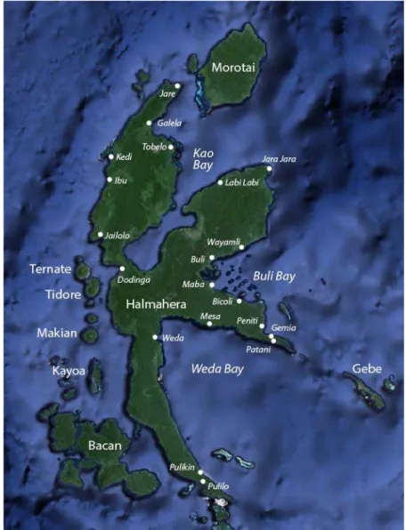
Figure 3: Location of islands, bays, and villages referred to in the text.
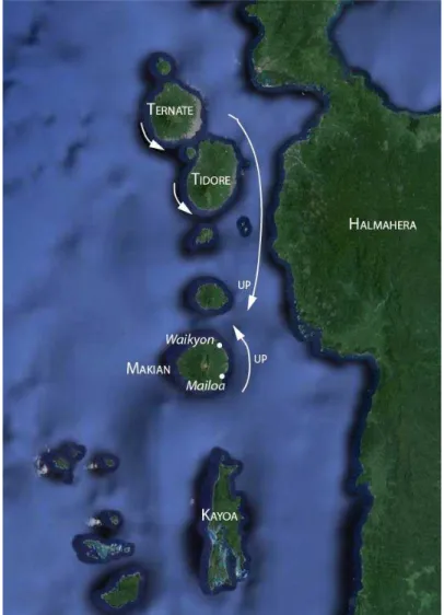
2.1. Ternate, Tidore and Makian Islands
Figure 4. UP direction in the offshore islands of Ternate, Tidore, and Makian
On all of these islands UP is anticlockwise, i.e., to the left along the coast when facing the sea.4 This convention has the advantage of consistency, in that in any particular location the directions of UP and DOWN are clearly determined. It also recalls similar small island systems such as that described for the Oceanic language Manam (ISO 639-3 mva). Manam contrasts a SEA-LAND axis with a left-right along the coast; regardless of where one is on the island awa is to the left facing the water, and ata is to the right (Lichtenberk 1983). However, in Halmahera this island system presents challenges in describing locations further afield on the island, since a location on the opposite of the island could in theory be accessed by going either clockwise or anticlockwise around the island. In practice there is some indeterminacy in the use of directionals to describe locations on the opposite side of the island. Bowden (1997:261) refers to these indeterminate areas as “transitional zones” between the intermediate and worldwide scales of orientation. When viewed from the main town Waikyon on the northeast coast of Makian, the entire southwest coast of Makian is either UP or simply ‘there’. This indeterminacy may be reinforced by the fact that the southwest coast is occupied by
4 Van Staden (2010) reports that UP can be used to indicate the direction clockwise along the east coast of
speakers of a different language (Moi); but the same phenomenon of transition zones occurs on Ternate, where the entire island is occupied by speakers of a single language. At first glance the system of orientation used on Ternate, Tidore, Makian and the neighboring islands seem to be at odds with that used on the west coast of Halmahera. On east coasts of the islands, where the major population centers are located, UP is to the left along the coast; immediately across the strait on the west coast of Halmahera UP is also to the left. Allen and Hayami-Allen (2002:30) describe this as “an apparent reversal of UP and DOWN,” presumably because UP is north on the islands and south along the coast of Halmahera. However, viewed without reference to an etic cardinal system the directions are consistent on both sides of the strait.
Between the offshore islands the UP and DOWN directions are used only for islands which are not immediate neighbors. In this case UP is to the right, mirroring the situation on the west coast of Halmahera, where UP is to the left along the coast. Thus, Makian is UP from Ternate. For neighboring islands which differ in size the LAND and SEA directionals are used. In this case, the larger island of the pair is always LAND from the smaller. Thus, Ternate Island is LAND from Ternate, and Makian is LAND from Kayoa. Halmahera is a special case of this convention, which by merit of its size is always LAND from any of the offshore islands. Neighboring islands of approximately the same size make use of demonstratives ‘here’ and ‘there’.
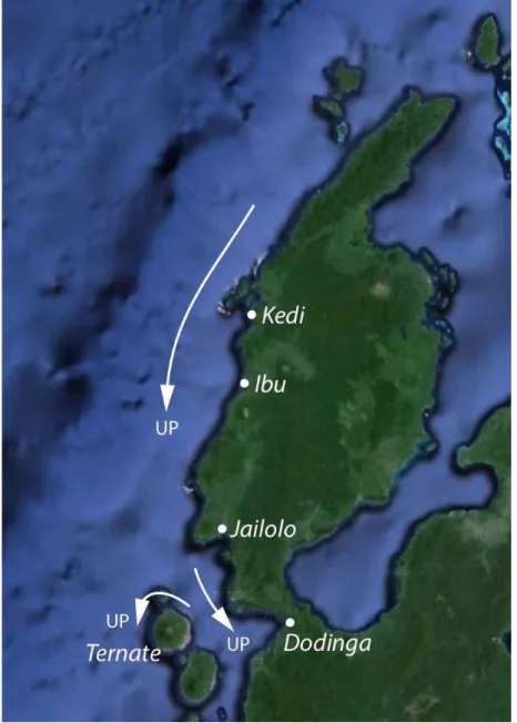
2.2. Northwest Coast of Halmahera
Figure 5. UP direction along the northwest coast of Halmahera
congruence likely reflects the social interaction between the island and mainland groups.5
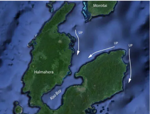
2.3. Kao Bay
The northern and northeastern peninsulas of Halmahera are separated by Kao Bay. The inner bay is some 60 km deep but only 7 km wide at the mouth. The outer bay opens quickly to both the north and east to the Halmahera Sea. The entire region is inhabited almost exclusively by speakers of Northeast Halmaheran, primarily the Tobelo and Galela dialects. Through this region UP is in the direction of the head of Kao Bay. Thus, on the west side of the bay UP is to the right facing the water, while on the east side of the bay UP is to the left facing the water. The consistency of the system across the region leads many speakers to equate UP with south and DOWN with north. Sailing across the bay from Tobelo town on the west side to Labi Labi village on the east side, UP remains to the right throughout the journey.
Figure 6. UP direction within Kao Bay and along the northeastern peninsula of Halmahera
However, there is a lack of congruence with respect to direction along the coast when facing the water. On the west side of the bay in Tobelo town UP is to the right facing the coast, while on the east side of the bay UP is to the left facing this coast. As a result the system must encounter a conflict somewhere at the head of the bay. That is, as one moves along the coast around the head of Kao Bay UP must change to DOWN, and vice versa. I was not able to determine precisely where this shift happens.
5 Curiously, Allen and Hayami-Allen (2002) report a different system along the northwest coast of
A similar shift from DOWN to UP occurs as one moves along the coast away from the mouth of the bay. On the west side the DOWN direction continues to be left facing the water as far as Jare on the northern tip of the northern peninsula of Halmahera. Beyond this point DOWN is to right facing the water, as it is along the entire west coast of Halmahera. On the east side the DOWN direction is to the right facing the water as far as Jara Jara village on the end of the northeastern peninsula. From Jara Jara on the tip of the northeastern peninsula the DOWN direction is not used. Both left and right along the coast is UP.
2.4. Morotai Island
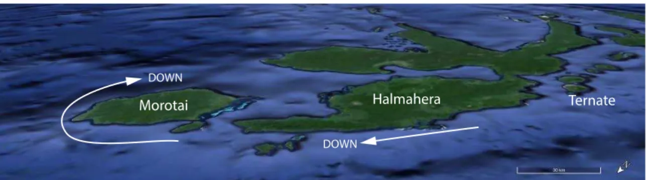
The large island of Morotai, located off the northern tip of Halmahera is occupied primarily by Galela speakers, with a group of Tobelo speakers residing on the east coast. As on Ternate, Tidore and Makian islands off the west coast of Halmahera, on Morotai the DOWN direction is clockwise around the island. This is really just an extension of the system which is in place along the entire west coast of Halmahera, as the following diagram makes clear.
Figure 7. Oblique view of Halmahera and Morotai Islands, looking SE, with the downward direction indicated
From the point of view of a mariner traveling the coast of Halmahera, Morotai does not appear so clearly as a separate island but rather as a continuation of the Halmaheran coast with an intervening bay. A mere 13 km separate the islands, and the island of Morotai wraps around to the south, making the intervening strait appear more as a bay. Thus it would be natural to extend the downward direction north along the west coast of Morotai, resulting in an equation of DOWN with clockwise (right facing the water), and UP with counterclockwise (left facing the water).
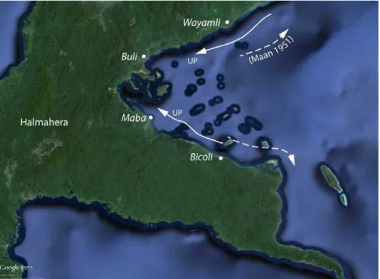
2.5. Buli Bay
Figure 8. UP direction along the coast of Buli Bay
This situation is clearest along the north side of the bay. Here UP is to right facing the water. Traveling from Ulol (Wayamli) to Buli toward the head of the bay one goes UP, pea nais Buli. This is consistent with the description in Maan’s grammar of Buli, which states “van Boeli naar het zuiden of westen gaande, zegt men: nais” (1940:70). Yoshida (1980:56) also cites this source in his study of Maluku directionals as UP being clockwise around Halmahera. However, in Maan’s later grammar of Buli this is apparently reversed. There Maan translates nais as “gaat naar boven (d.i. van Buli naar het Noorden)” (1951:93). This may well be an editorial mistake in Maan’s latter work, but it lends an additional sense of confusion to the system as realized in inner Buli Bay. In a more recent study Bubandt reports that “the village of Waiflí [Wayamli] is itself the endpoint for upward movement along the coast” (1997:145). The inner bay is bisected by a peninsula several kilometers in length, as well as several large islands which may confound interpretation of the UP-DOWN axis.
Between the two extremes of Maba and Bicoli there is quite a lot of variability, with some speakers agreeing with the Maba pattern and other agreeing with Bicoli. One point of consistency in this region is a general reluctance to use directionals UP and DOWN for anything beyond the local scale. A speaker in Gotowasi used UP to describe the direction from Waci to Bicoli (fan nya na Woso), but refused to use UP to describe the direction further along the coast at Gemia, offering instead the non-specific mto ‘there’, fan mto na Gemia.
2.6. Southeastern Peninsula
The eastern peninsula of Halmahera is occupied by speakers of Patani, a language nearly mutually-intelligible with Maba. The principal villages are Patani, on the south coast of the peninsula, and Peteleo and Gemia, on the north coast. The peninsula here is narrow and long, extending about 30 km but not exceeding 4 km in width. A steep mountain ridge approximately 300 m high runs along the spine of the peninsula but does not impede communication. The usual route of travel between the north and south coasts of the peninsula is by land over the mountain pass rather than by water around the eastern cape. Nevertheless, although the waters around the cape can be rough during a southerly breeze, the area is regularly used by fisherman and travelers.
Along the north coast in Peniti and Gemia UP is to the left facing the sea, consistent with directions in Bicoli to the west. One thus goes nipop DOWN toward the cape and nya UP toward Bicoli and Maba. On the south coast in the village of Patani UP is also to the left, as on the north coast. The systems on the two sides of the peninsula are thus consistent in two ways. First, on both the north and south coasts UP is to the left as one faces the water. Second, as one travels between the north and south coast areas by sea the directions remain the same. Traveling from the south coast to the north around the cape is consistently UP, while traveling in the opposite direction is DOWN. That is, one does not shift directional orientation as one rounds the cape.
Figure 9. UP direction along the coast of the southeastern peninsula of Halmahera
coast speakers are reluctant to use the UP-DOWN directions to refer to anything beyond the local bay. One speaker with whom I spoke would use them only for the immediate area of the beach which extends for about 1 km in front of the village. From Patani village the coastline stretches in a straight line east-northeast for nearly 100 km into Weda Bay. Villages along this coast would thus logically be DOWN, since they lie along the coast to the right as one faces the water. Yet, speakers avoid using either UP or DOWN to refer to those directions; instead they use fan nan ‘going seaward’.
In other words the UP-DOWN axis along the south coast at Patani has only a local interpretation. UP and DOWN can be used within the village but not for locations beyond the village. It may be that the use of UP and DOWN in this vicinity has been innovated by speakers migrating from the north coast to the south. It would be natural for these speakers to carry with them the association of the UP with left. Yet they are keenly aware that this usage differs from that of their neighbors to the west, for whom UP is to the right along the coast.6 So in this one small area of Patani village, speakers have a reversed system for local usage.
2.7. Weda Bay
The southeastern and southern arms of Halmahera together define the expansive Weda Bay. With the exception of some Tidore and Tobelo speaking immigrant communities along the east coast of the southern peninsula, the bay is populated by speakers of SH languages. The inner bight of the bay is home to speakers of Sawai, and directional usage is consistent throughout this region; the UP direction points into the bay. Thus, along the west side of the bay UP is to the left facing the water, while along the north side of the bay UP is to the right facing the water. The UP direction actually extends somewhat around the bight of the bay to the east. As in Tobelo there is folk wisdom which associates the UP-DOWN axis with cardinal directions, however, in Weda the south cardinal direction is conventionally associated with DOWN rather than UP.
6 Further evidence for the innovative status of the local south coast system can be found in the name for
Figure 10. UP direction along the coast of Weda Bay
Because UP points into the bay, the direction of UP along the coast when facing the water must shift from left to right at some point between Weda village and Mesa. However, as in Kao Bay it is difficult to locate this point precisely. In practice speakers in Weda avoid the use of UP when referencing nearby locations, though they continue to freely use DOWN in reference to locations to the south. Instead speakers use the SEA directional or simply omit the directional altogether. Thus, from Weda one says fan nalau po Mesa ‘going seaward to Mesa’ or simply fan po Mesa ‘going to Mesa’. For directions further away beyond the north coast of the bay the UP direction is used. Thus, the large island of Gebe, located 40 km beyond the southeastern tip of Halmahera is UP from Weda, as are the Raja Ampat Islands and Papua. Ternate is also UP from Weda.
2.8. Southern Peninsula
Figure 11. UP direction in the Gane region along the southern peninsula of Halmahera
Teljeur 1987:355, fig. 3). As soon as one walks the 200 m around the bend of the mouth of the bay the normal equation of left with UP pertains again.
On the opposite side of the peninsula the directions mirror those on the west coast. From the village of Pulikin on the east coast the UP direction remains toward the southern cape, just as on the west side. Likewise, the DOWN direction extends north (left) along the coast, but according to Teljeur (1987:350) only as far as Cape Foya. Beyond this Teljeur report speakers use noge ‘there, yonder’. Teljeur points out a geographic boundary where the otherwise straight coastline juts out to the east about 5 km. Though not remarked by Teljeur, this is also a linguistic boundary, as speakers of the Papuan languages Tobelo and Ternate can be found in this region intervening between Gane speakers to the south and Weda speakers to the north. During our field work I found speakers reluctant to even extend the DOWN direction this far, switching to noge even for locations still south of Cape Foya. In any case, just as in Patani on the south coast of the eastern peninsula, there is a recognition among speakers in Pulikin that the orientation system there is at odds with the system in Weda Bay to the north. Thus, while speakers on the west coast freely extend DOWN along the entire coast of Halmahera, on the east coast of the peninsula speakers are much more circumspect, preferring to use UP and DOWN only locally.
2.9. Summary of coastal orientation
Figure 12. Summary of UP direction along the coast of Halmahera
Before attempting to account for the orientation along the coast in Figure 12, I will first describe the orientation system used away from the coast in the interior of the island. 3. Riverine orientation
So far our discussion of orientation in Halmahera has focused on the coastal region, ignoring the use of directionals inland. To some extent this is a natural consequence of geography. Halmahera is a large island comprised of four long peninsulas, and the ratio of coastline length to land area is relatively high. All modern settlements of any significance are at or near the coast, with the one exception of Duma, a large village located on an inland lake approximately 5 km from the coast at Galela. Nevertheless, vast inland areas of the island—particularly on the northeast and southeast peninsulas— continue to be occupied by semi-nomadic tribes known as Forest People (Tobelo: o hongana ma nyawa).7 The majority of these people speaks a variety of Tobelo or
Modole (Northeast Halmaheran), though some on the southeast peninsula speak a variety of the Austronesian language Weda.
The orientation system used by the Forest People employs the same UP-DOWN and SEA-LAND axes as used by the coastal dwelling population, but these are applied with reference to the river rather than the coast. In this context the UP-DOWN axis is parallel to the river, and the SEA-LAND axis is orthogonal. The LAND direction is away from the river, and the SEA direction is toward the river. While on the coast it can be difficult to discern the motivation for the choice of UP and DOWN direction, in the riverine usage the motivation is clear. The UP direction is up against the flow of the current, and the DOWN direction is down with the flow of the current.
Figure 13: Riverine directional usage
As is other riverine systems, the choice of reference river is pragmatically determined (cf. Brucks 2015). Thus a speaker located on a side stream has a choice as to whether to make reference to that smaller stream or to the larger main valley. For example, a speaker located at point S in Figure 14 could use the UP directional to refer to location a, with reference to the tributary stream, and could use the same UP directional to refer to location b, with reference to the main stream.
Figure 14: Choice of reference river between tributary stream and main stream. Both can be considered UP from the speaker (S), depending on which stream is
used for reference
Taylor (1984:102), near the mouths of rivers the riverine and coastal senses are in conflict, since the downstream direction could be considered both DOWN and SEA. Stated another way, when used in a coastal location the UP direction is ambiguous between its upcoast and upriver senses. For example, from the village of Labi Labi, located near the mouth of the Gogaili River, UP can refer to the direction along the coast toward the (coastal) village of Iga or to the direction upstream along the Gogaili River (Figure 15).
Figure 15. UP orientation along the coast and along the Gogaili River in the vicinity of Labi Labi, Northeast Halmahera. View looking northeast
Again, such ambiguity is an inherent feature of riverine orientation systems, and is also found in the choice between reference to main and tributary streams. In the transitional zone near the coast, two bodies of water are available with which to orient the system: the river and the sea. Speakers thus have choices, and some variation is expected. However, beyond this transitional zone there is no ambiguity: UP is upstream. In other words, the Forest Tobelo system is riverine.
4. Uniting the coastal and riverine usages
While a riverine explanation clearly accounts for the orientation of UP on rivers, it is not immediately obvious how such an explanation can be applied in the coastal context. However, the overall patterning of the UP direction around Halmahera (Figure 12) suggests a solution. In each of the three large bays defined by the arms of Halmahera— Kao, Buli, and Weda—the UP direction points into the bay. It is as if the bay were an extension of the river, with upstream pointing up toward the head of the bay, and downstream pointing down toward the mouth of the bay. Just as the river flows down into the bay, the bay “flows” down toward the ocean.
narrows from 50 km at its widest point down to a mere 3 km at its narrowest. It is nearly blocked by the Kusu Islands, giving the appearance of a large bay. The alignment of the UP direction with the direction into the Patinti Strait is thus consistent with the riverine explanation.
As second area of residue not explained by the equation of UP with “into the bay” is found in the offshore islands, on all of which the UP direction is to the left along the coast (i.e., anticlockwise). On these islands there are no large bays to motivate equating UP as into the bay. Yet the consistency of the UP direction on these islands is remarkable and unlikely to be accidental. One possible explanation can be found by considering the geography in the region of the island of Morotai, located just off the northern tip of Halmahera. At 65 km in length, Morotai is the largest of the offshore islands. As already discussed in section 2.4 above, the southern end of Morotai extends south of the coast of the Halmahera by nearly 30 km, the entrance to the strait between the islands is not obvious. To an observer transiting between Halmahera and Morotai the strait appears as a small bight, and the coastline appears continuous (see Figure 7). So it is natural that the UP direction along the coast of Halmahera would be extended to the coast of Morotai as well. This conception of UP as to the left along the coast could plausibly serve as a template which was then copied by analogy to other small islands, including Ternate, Tidore, and Makian. Alternatively, the islands may have copied the equation of left as UP directly from the usage along the west coast of mainland Halmahera.
Two remaining areas of discrepancy are found at the tips of Weda Bay, namely the Gane region at the tip of the southern peninsula of Halmahera and the Patani region at the tip of the eastern peninsula of Halmahera (see Figure 10). Here the local and regional scales appear to be in conflict. Both of these situations have been discussed above and present some similarities with each other. Both peninsulas are extremely narrow and readily traversed on foot. On both peninsulas the speakers on either side are closely related and speak the same language. And at both ends of Weda Bay speakers are reluctant to use the DOWN orientation very far into Weda Bay. In Pulikin on the southern peninsula speakers extend DOWN a bit further (toward Cape Foya) but still seem aware of the conflict between their local usage and that near the head of Weda Bay. In Patani on the southeastern peninsula this reluctance begins anywhere beyond the immediate vicinity of the village. The riverine explanation accounts for the direction from Patani to Weda, since Weda is located UP into the bay. But the riverine explanation fails to account for the local usage in Patani, where UP is to the left along the coast. Two possible competing motivations may account for this apparent discrepancy. First, the equation of UP as the left along the coast allows for consistency between Patani and neighboring Gemia, located a mere 5 km over the mountains on the north coast of the peninsula. Second, the equation of UP as left along the coast allows consistency with the larger navigational scale in which Gebe, Raja Ampat, and the New Guinea mainland are all considered UP from Patani. As noted in section 2.7, this competing navigational scale usage of UP is also found in Weda.
also readily explains the use of the system by the Forest People of the interior of Halmahera.
5. Implications for linguistic prehistory and language convergence
Given that the orientation system in Halmahera has both a coastal and a riverine use, we can speculate as to which came first. That is, was the riverine usage adapted from the coastal use, or was the coastal use derived from the riverine usage? Several lines of evidence support the latter interpretation. First, the riverine usage in Halmahera is very atypical for Austronesian languages. Blust asserts that “the most general principle of macro-orientation in Austronesian languages is the land-sea axis, associated with the PAN [Proto-Austronesian] terms *daya ‘toward the interior’ and *lahud ‘toward the sea’” (2009:311). Further, Blust later reconstructs *daya as ‘upstream, toward the interior’ and *lahud as ‘downstream, toward the sea’ (Blust & Trussel 2010), reflecting a unified view of the inland and upstream concepts. This equation of inland and upstream is well-motivated, given that rivers do eventually flow to the sea. However, in Halmahera these concepts are kept distinct. In the Austronesian languages of Halmahera the reflex of *daya is used for ‘away from the river’, not ‘upstream’. This situation is reported very rarely for Austronesian languages; I know of only two confirmed cases, from the Central Sarawak languages Dalat and Kanowit Melanau. Dalat (ISO 639-3 del) has dayeh ‘away from river’ and alud ‘toward the river’ < *lahud (Clayre 1973), while Kanowit (ISO 639-3 kxn) has naya < *daya but has innovated win ‘toward the river’ (Alex Smith, pers. comm.).
The much more typical Austronesian pattern is to repurpose the SEA-LAND axis as a downriver-upriver axis. This pattern is so prevalent that Adelaar even goes so far as to propose an implicational universal regarding the use of orientation terms in riverine contexts in Borneo. Namely, “[i]f a language has reflexes of the original terms *lahud and *daya, these have the meaning, respectively, of ‘downstream area’ and ‘upstream area’, rather than ‘towards the sea’ and ‘towards the interior’” (Adelaar 1997:69).
Other non-geographic explanations for the UP-DOWN orientation based on ocean currents and migration history are equally tenuous. There are no prevailing currents in Halmahera, as suggested by Bowden (2005a:145–6); rather, the currents are driven by the wind, which reverses direction from the Northwest to Southeast monsoon (National Geospatial-Intelligence Agency 2009, Ross 1995). And rather than “retaining their ancestors usages” (Bowden 2001:285), migrants in Halmahera assimilate to the orientation used in their new location instead of retaining the orientation as used in their home location. This process of assimilation continues today as new migrants arrive from outside Halmahera.
A third reason to favor an original riverine usage can be found in the antiquity of the interior settlement of Halmahera. The significance of the interior population has been obscured in the modern academic literature, which focuses almost exclusively on coastal populations. Until recently, contact between the Forest People and the coastal dwellers was extremely limited. During several months of field work in 1992 and 1995 in coastal villages on the east side of Kao Bay the author encountered only three forest-dwelling Tobelo speakers. Most shun western clothing and have only limited informal trade with coastal residents. Missionary efforts over the past two decades have resulted in coastal resettlement of many Forest People at Tanjung Lili on the north side of Bull Bay (Duncan 1998), but relations between the still nomadic Forest People and the coastal people remain tense (Aman Maluku Utara 2015, Nurgianto 2015). Since the reconciliation following the ethnic violence of 1999 the Forest People have gained increasing political recognition, and the once mysterious ways of the forest dwellers are becoming more well-known (Duncan 2013).
Though largely overlooked until recently, the Forest People have a long history in Halmahera. It is important to understand that the Forest People of Halmahera are not a racially or linguistically distinct group but rather a remnant of a broader hunter-gatherer society which existed on Halmahera prior to the Austronesian migration to the region. Whether or not the Forest People also predate the arrival of the ancestors of the current NH speakers is not known, though if so they have subsequently adopted the languages of those later arrivals. Furthermore, while the NH languages are not sufficiently differentiated from each other to support a deep time depth, it is clear is that the Papuan speakers arrived in Halmahera prior to the Austronesians (Bellwood 2007). Halmahera itself has been continuously occupied by humans for at least 30,000 years, though only in the last 15,000 years do we begin to find evidence of a broader economy with anthropogenic transport of plants and animals. An increase in palm pollen 6,000 years ago may be evidence of an early intensification of sago cultivation (Bellwood 2007:234) and subsequent population expansion.
journeys taken in 1863 following rivers on foot upstream and descending downstream via raft. The journey from Buli on Buli Bay to Wasile on Kao Bay covers 60 miles in three days, approximately three quarters of the journey following three large rivers. Another journey described by Cambier begins on the west coast of Halmahera and proceeds 36 miles east through the forest to the Sengaji River, then descending in rafts to the north coast of the southeastern peninsula near Maba. These are not journeys of exploration; rather, Cambier describes these routes as being among the “main roads” of Halmahera (1872:249).
There are conflicting local accounts as to the origin of the Forest People. Many coastal dwelling Tobelo today believe that the Forest People of northeast Halmahera are former coastal dwellers who have fled to the interior. This perception may date to the time of the Japanese occupation in the mid-20th century, during which many Halmaherans took refuge in the interior. However, oral history accounts from earlier times provide evidence for a past migration from the interior to the coast and subsequent cultural adaptations to a maritime environment (Hueting 1921). So regardless of whether the Forest People represent a remnant interior population or a back-migration following coastal settlement, it is clear that the interior society of the Forest People predates the modern coastal society. We can thus reasonably assume that the riverine usage of directional by these interior dwelling people also predates the coastal usage.
6. Conclusion
The spatial orientation system in Halmahera has been the subject of intensive study over the past several decades—with good reason. Spatial orientation plays a major role in the languages of Halmahera, crossing language boundaries and uniting the region within a single conceptual system. Bowden (2005b:789) estimates that at least 30% of narrative clauses in Taba (SH) include directional terms. In spite of the clear importance of the system, the basic principles underlying the orientation of the UP-DOWN axis have remained elusive, the subject of much speculation and mystery. This paper has attempted to shed some light on the issue by presenting the most comprehensive mapping of orientation in Halmahera to date. While many gaps in our knowledge still remain, the general picture that emerges is one in which UP points into large bays, left along the coast of small islands, and upstream along rivers. It has been suggested that the original orientation system in Halmahera was riverine, and that this system has diffused across both the Austronesian and non-Austronesian languages of the region. From a typological perspective three key features characterize the Halmahera system:
1. Two orthogonal axes, contrasting an upcoast-downcoast (or upstream-downstream) axis and a toward vs. away from water axis.
2. Both axes are geocentric, determined by local geography. Neither is fixed or cardinal (in the sense of François 2004).
3. The terms ‘up’ and ‘down’ have both horizontal and vertical senses, but the horizontal sense is the default, primary sense.
Modern views of Halmahera and East Nusantara more generally tend to impose a maritime view of a coastal people connected to the sea. Yet the reports of early visitors suggest that the coast of Halmahera was sparsely populated as compared to the inland populations living along rivers. Nevertheless, an Austronesian coastal characterization has tended to color our understanding of spatial orientation in Halmahera, leading to unsubstantiated claims that “folk orientation does not seem to be well-suited to a tropical forest environment” (Yoshida 1980:38). This coastal view overlooks the very natural riverine interpretation, which is perfectly suited to navigation through the interior forests of Halmahera, and indeed still used by the Forest People of Halmahera. While the NH and SH languages have a relatively shallow time depth, the Forest People may well be descendants of an ancestral Halmahera settlement, predating the arrival of modern NH and SH speakers. Thus, the riverine system could represent the original basis for the Halmaheran system of spatial orientation. This possibility is consistent with Palmer’s suggestion that the current Halmahera system results from “borrowing the system present in pre-existing non-Austronesian languages” (2002:149). Additional evidence for the primacy of the riverine system can be found in the identity between the upstream-downstream and upcoast-downcoast axes. If the coastal use of the UP-DOWN axis predates the riverine use, then it is difficult to explain why it is that this axis was aligned with the river, rather than the SEA-LAND axis as is common in so many Austronesian languages. A more economical—and at least equally plausible— explanation is that the riverine use of the UP-DOWN axis predates the coastal use. Ultimately the explanation for the orientation of the UP-DOWN axis is likely to be more complex, involving a number of factors beyond just the riverine usage. Teasing out these factors will require further research, and crucially, more documentation. Within Halmahera there remain significant gaps in our knowledge of directional use, especially on Bacan Island. Beyond Halmahera spatial orientation systems are only sporadically mentioned. Even when we know that a language has terms for ‘upcoast’ and ‘downcoast’, the usage of these terms at different locations tends not to be thoroughly mapped. We must be careful lest knowledge of spatial orientation in Halmahera (and beyond) slips through the disciplinary cracks between linguistics, geography, and anthropology.
Abbreviations
1 first person NMM North Moluccan Malay
2 second person PL plural
3 third person PUNCT punctual
ALL allative RNM relational noun marker
DOWN downcoast, downriver SEA seaward, toward river
EXC exclusive SG singular
LAND landward, away from river SH South Halmaheran
LOC locative UP upcoast, upriver
NH North Halmaheran V verbalizer
NHUM non-human VEN venitive
References
Adelaar, K. Alexander. 1997. An exploration of directional systems in West Indonesia and Madagascar. In Gunter Senft (ed.) Referring to Space: Studies in Austronesian and Papuan Languages (Oxford Studies in Anthropological Linguistics 11). Oxford: Oxford University Press. 53–82.
Allen, R.B., Jr. & Rika Hayami-Allen. 2002. Orientation in the Spice Islands. In M. Macken (ed.) Papers from the Tenth Annual Meeting of the Southeast Asian Linguistics Society. Phoenix: Arizona State University, Program for Southeast Asian Studies. 21–38.
Aman Maluku Utara. 2015. Torang Tara Bunuh Dorang. http://amanmalut.or.id/torang-tara-bunuh-dorang/
Bellwood, Peter Stafford. 2007. The Prehistory of the Indo-Malaysian Archipelago, 3rd edn. Canberra: Australian National University.
Blust, Robert Andrew. 1978. Eastern Malayo-Polynesian: A subgrouping argument. In S. A. Wurm & L. Carrington (eds.), Proceedings of the Second International Conference on Austronesian Linguistics (Pacific Linguistics C-61). Canberra: Australian National University. 181–234.
Blust, Robert Andrew. 2009. The Austronesian Languages. Canberra: Asia-Pacific Linguistics.
Blust, Robert Andrew & Stephen Trussel. 2010. Austronesian Comparative Dictionary, web edition. http://www.trussel2.com/acd/
Bowden, John. 1997. The meanings of directionals in Taba. In Gunter Senft (ed.) Referring to Space: Studies in Austronesian and Papuan Languages (Oxford Studies in Anthropological Linguistics 11). Oxford: Clarendon. 251–68.
Bowden, John. 2001. Taba: Description of a South Halmahera Austronesian language, (Pacific Linguistics 521). Canberra: Pacific Linguistics.
Bowden, John. 2005a. Language contact and metatypic restructuring in the directional system of North Maluku Malay. Concentric: Studies in Linguistics 31 (2). 133–58. Bowden, John. 2005b. Taba. In Alexander Adelaar & Nikolaus Himmelmann (eds.),
The Austronesian Languages of Asia and Madagascar. London: Routledge. 769– 792.
Brucks, Caleb. 2015. The creation of narrative space: The directional system of Upper Tanana. M.A. thesis, University of Regina.
Bubandt, Nils. 1997. Speaking of places: Spatial poesis and localized identity in Buli. In James J. Fox (ed.) The Poetic Power of Place. Canberra: Research School of Pacific and Asian Studies. 131–62.
Burenhult, Niclas & Stephen C. Levinson. 2008. Language and landscape: A cross-linguistic perspective. Language Sciences 30 (1). 135–50.
Clayre, Iain. 1973. Notes on Spatial Deixis in Melanau. Anthropological Linguistics 15 (2). 71–86.
Duncan, Christopher. 1997. Social change and the reformulation of identity among the Forest Tobelo of Halmahera Tengah. Cakalele 8. 79–90.
Duncan, Christopher. 1998. Ethnic identity, Christian conversion and resettlement among the Forest Tobelo of northeastern Halmahera, Indonesia. Ph.D. dissertation, Yale University.
Duncan, Christopher. 2013. Violence and Vengeance: Religious conflict and its aftermath in eastern Indonesia. Ithaca: Cornell University Press.
François, Alexandre. 2015. The ins and outs of up and down: Disentangling the nine geocentric space systems of Torres and Banks languages. In Alexandre François, Sébatien Lacrampe, Franijeh M. & Stefan Schnell (eds.), The Languages of Vanuatu: Unity and Diversity (Studies in the Languages of Island Melanesia, 5). Canberra: Asia Pacific Linguistics Open Access. 137–95.
Haugen, Eina. 1957. The semantics of Icelandic orientation. Word 13. 447–60.
Hayami-Allen, Rika. 2001. A descriptive study of the language of Ternate, the northern Moluccas, Indonesia. Ph.D. Dissertation, University of Pittsburg.
Holton, Gary. 2003. Tobelo (Languages of the World/Materials 328). Munich: LINCOM Europa.
Holton, Gary. 2015. A geographic explanation for the usage of spatial orientation terms in Halmahera. Paper presented at International Conference on Austronesian Linguistics, Taipei, July 18–22.
Holton, Gary & Marian Klamer. 2017. The Papuan languages of East Nusantara and the Bird's Head. In Bill Palmer (ed.) The Languages and Linguistics of the New Guinea: A Comprehensive Guide (The World of Linguistics, vol. 4). Berlin: Mouton.
Hueting, Anton. 1921. De Tobeloreezen in hun denken en doen [part 1]. Bijdragen tot de Taal, Land en Volkenkunde 77 (1). 217–357.
Leer, Jeff. 1989. Directional systems in Athapaskan and Na-Dene. In Eung-Do Cook & Keren D. Rice (eds.), Athapaskan Linguistics: Current Perspectives on a Language Family. Berlin: Mouton de Gruyter. 575–622.
Levinson, Stephen C. 2003. Space in Language and Cognition. Cambridge: Cambridge University Press.
Lichtenberk, František. 1983. A Grammar of Manam, (Oceanic Linguistics Special Publication no. 18). Honolulu: University of Hawai’i Press.
Litamahuputty, Betty. 2012. Ternate Malay: Grammar and Texts. Ph.D. dissertation, Leiden University.
Maan, G. 1940. Boelisch-Nederlandsche woordenlijst met Nederlandsch-Boelisch register (Verhandelingen van het Koninklijk Bataviaasch Genootschap van Kunsten en Wetenschappen 74). Bandoeng: AC Nix & Co.
National Geospatial-Intelligence Agency. 2009. Sailing Directions (enroute): New Guinea, 11th edn, (Publication 164). Bethesda, Maryland: National Geospatial-Intelligence Agency.
Nurgianto, Budhy. 2015. Polda Maluku Utara Tolak Penangguhan Warga Togutil. Tempo, March 9.Online: https://nasional.tempo.co/read/648457/polda-maluku-utara-tolak-penangguhan-warga-togutil
Palmer, Bill. 2002. Absolute spatial reference and the grammaticalisation of perceptually salient phenomena. In Giovanni Bennardo (ed.) Representing Space in Oceania: Culture in language and mind. Canberra: Australian National University. 107–57.
Palmer, Bill. 2015. Topography in language: Absolute frame of reference and the topographic correspondence hypothesis. In Rik De Busser & Randy J. Lapolla (eds.), Language Structure and Environment: Social, cultural, and natural factors. Amsterdam: John Benjamins. 179–226.
Ross, Malcolm. 1995. Proto-Oceanic terms for meteorological phenomena. Oceanic Linguistics 34 (2). 261–304.
Sheldon, Deidre. 1991. Setting a course in Galela: An orientation system of North Halmahera. In Tom Dutton (ed.), Papers in Papuan Linguistics no. 1 (Pacific Linguistics A-73). Canberra: Australian National University. 147–60.
van Staden, Miriam. 2000. Tidore: A Linguistic Description of a Language of the North Moluccas. Ph.D. thesis, Leiden University.
van Staden, Miriam. 2010. A Grammar of Tidore. Berlin: Mouton.
Taylor, Paul Michael. 1983. North Moluccan Malay: notes on a "substandard" dialect of Indonesian. In J. T. Collins (ed.), Studies in Malay Dialects, part II. Jakarta: Universitas Atma Jaya.
Taylor, Paul Michael. 1984. Tobelorese deixis. Anthropological Linguistics 26. 102–22. Teljeur, Dirk. 1987. Spatial orientation among the Giman of South Halmahera. In
E.K.M. Masinambow (ed.), Halmahera dan Raja Ampat Sebagai Kesatuan Yang Majemuk. Jarkarta: Lembaga Ekonomi dan Kemasyarakatan Nasional. 347–66.
Voorhoeve, C. L. 1988. The languages of the northern Halmaheran stock. Papers in New Guinea Linguistics, no. 26 (Pacific Linguistics A-76 Pacific Linguistics A-76). Canberra: Australian National University. 181–209.
Voorhoeve, C. L. 1994. Contact-induced language change in the non-Austronesian languages in the north Moluccas, Indonesia. In T. Dutton & D. T. Tryon (eds.), Language Contact and Change in the Austronesian World. Berlin: Mouton de Gruyter. 649–74.
Wassmann, Jürg & Pierre R. Dasen. 1998. Balinese spatial orientation: some empirical evidence of moderate linguistic relativity. Journal of the Royal Anthropological Institute 4. 689–711.